(date: 2024-01-19 15:57:50)
date: 2024-01-19, from: NOAA tornado/severe thunderstorm watches, mesoscale discussions, convective outlooks, fire weather outlooks
No watches are valid as of Fri Jan 19 17:50:02 UTC 2024.
https://www.spc.noaa.gov/products/watch/ Save to Pocket
date: 2024-01-19, from: NOAA tornado/severe thunderstorm watches, mesoscale discussions, convective outlooks, fire weather outlooks
No Mesoscale Discussions are in effect as of Fri Jan 19 17:50:02 UTC 2024.
https://www.spc.noaa.gov/products/md/ Save to Pocket
date: 2024-01-19, from: NOAA tornado/severe thunderstorm watches, mesoscale discussions, convective outlooks, fire weather outlooks

Day 2 Convective Outlook
NWS Storm Prediction Center Norman OK
1100 AM CST Fri Jan 19 2024

Valid 201200Z - 211200Z

...NO THUNDERSTORM AREAS FORECAST...

...SUMMARY...
Thunderstorms are not expected across the continental U.S. Saturday
or Saturday night.

...Synopsis...
Water-vapor imagery midday Friday shows a potent mid- to upper-level
low/trough over the eastern Pacific west of the CA coast.  This
feature is forecast to weaken as it moves northeast into the Pacific
Northwest during daylight hours on Saturday while a weaker
perturbation moves through the larger-scale trough's base and into
southern CA late Saturday night.  Farther east, a mid-level ridge
will shift into the Great Plains concurrent with a trough's
influence abating along the East Coast.  In the low levels, cool
and/or stable conditions over much of the Lower 48 states will
preclude thunderstorm development.

..Smith.. 01/19/2024
https://www.spc.noaa.gov/products/outlook/day2otlk_1730.html Save to Pocket
date: 2024-01-19, from: NOAA Weather Forecasts

Day 1 Fire Weather Outlook
NWS Storm Prediction Center Norman OK
1048 AM CST Fri Jan 19 2024

Valid 191700Z - 201200Z

...NO CRITICAL AREAS...

No changes. See previous discussion below.

..Bentley.. 01/19/2024

.PREV DISCUSSION... /ISSUED 1241 AM CST Fri Jan 19 2024/

...Synopsis...
High pressure will build today across the northern Rockies as an
upper-level low brings rain and snow chances across the Pacific
Northwest. Across the central/eastern US, a cool post-frontal air
mass will be in place under building surface high pressure. Given
the cool and moist conditions, fire weather concerns will remain low
across the CONUS today.

...Please see www.spc.noaa.gov/fire for graphic product...
https://www.spc.noaa.gov/products/fire_wx/fwdy1.html Save to Pocket
date: 2024-01-19, from: NOAA tornado/severe thunderstorm watches, mesoscale discussions, convective outlooks, fire weather outlooks

Day 1 Convective Outlook
NWS Storm Prediction Center Norman OK
1030 AM CST Fri Jan 19 2024

Valid 191630Z - 201200Z

...NO SEVERE THUNDERSTORM AREAS FORECAST...

...SUMMARY...
Severe thunderstorms are not expected, but a few thunderstorms may
occur across parts of south Florida and along the central California
Coast.

...Discussion...
An amplified but progressive large-scale pattern will exist over the
CONUS, including a prominent upper trough over the Eastern CONUS. A
semi-moist environment, albeit with weak lapse rates, may support a
few thunderstorms today across or near south Florida prior to a cold
front moving through the region.

In the West, a few lightning flashes will be possible particularly
into tonight, as convection moves inland ahead of the advancing
Pacific trough and an associated surface cold front. Weak
instability and the anticipated weak/elevated nature of this
convection is suggestive of a negligible severe risk.

..Guyer/Lyons.. 01/19/2024
https://www.spc.noaa.gov/products/outlook/day1otlk_1630.html Save to Pocket
date: 2024-01-19, from: NOAA tornado/severe thunderstorm watches, mesoscale discussions, convective outlooks, fire weather outlooks

Day 1 Convective Outlook
NWS Storm Prediction Center Norman OK
0645 AM CST Fri Jan 19 2024

Valid 191300Z - 201200Z

...NO SEVERE THUNDERSTORM AREAS FORECAST...

...SUMMARY...
A few thunderstorms may be noted across parts of south Florida and
along the central California Coast.

...Synopsis...
The upper flow field across the U.S. will be characterized by fast
cyclonic flow over the eastern 2/3 of the country today and tonight,
while ridging prevails over the West.  Ridging will be gradually
shunted eastward however, as a low-trough over the eastern Pacific
approaches -- and eventually reaches -- the West Coast.

At the surface, a cold front will move southward across Florida and
the Gulf of Mexico, as high pressure gradually expands southward to
encompass a large portion of the U.S. east of the Rockies.  While
cold stable air associated with this high will preclude thunder
potential in most areas, showers and a few thunderstorms will be
possible across parts of southern Florida ahead of the front, today
and into this evening.  However, weak lapse rates -- and resulting
weak CAPE -- will preclude any appreciable severe potential.

In the West, a few lightning flashes will be possible later in the
period, as convection moves inland ahead of the advancing Pacific
trough and an associated surface cold front.  However, weak
instability and the anticipated/elevated nature of this convection
suggests minimal, if any, severe risk.

..Goss.. 01/19/2024
https://www.spc.noaa.gov/products/outlook/day1otlk_1300.html Save to Pocket
date: 2024-01-19, from: NOAA Weather Forecasts

Day 2 Fire Weather Outlook
NWS Storm Prediction Center Norman OK
1251 AM CST Fri Jan 19 2024

Valid 201200Z - 211200Z

...NO CRITICAL AREAS...

...Synopsis...
An upper-level ridge will build in across the CONUS by Saturday.
Under this regime, primarily light winds will remain keeping fire
weather concerns low.

..Thornton.. 01/19/2024

...Please see www.spc.noaa.gov/fire for graphic product...
https://www.spc.noaa.gov/products/fire_wx/fwdy2.html Save to Pocket
date: 2024-01-18, from: NOAA tornado/severe thunderstorm watches, mesoscale discussions, convective outlooks, fire weather outlooks

Day 1 Convective Outlook
NWS Storm Prediction Center Norman OK
0619 PM CST Wed Jan 17 2024

Valid 180100Z - 181200Z

...NO THUNDERSTORM AREAS FORECAST...

...SUMMARY...
Thunderstorms remain unlikely tonight.

...01z Update...

Stable conditions exist across the CONUS this evening with offshore
flow now dominant across the FL Peninsula. Any meaningful buoyancy
has been shunted south of the FL Straits, thus the prospect for
lightning is very low tonight.

..Darrow.. 01/18/2024
https://www.spc.noaa.gov/products/outlook/day1otlk_0100.html Save to Pocket
date: 2024-01-17, from: NOAA tornado/severe thunderstorm watches, mesoscale discussions, convective outlooks, fire weather outlooks

Mesoscale Discussion 0078
NWS Storm Prediction Center Norman OK
0149 PM CST Wed Jan 17 2024

Areas affected...Washington...northeast Oregon...northern
Idaho...and western Montana

Concerning...Heavy snow

Valid 171949Z - 172345Z

SUMMARY...Heavy snowfall rates between 1-2 inches per hour are
probable - especially at higher elevations - through the afternoon
and early evening.

DISCUSSION...Surface observations over the past hour have reported
an uptick in snowfall intensity across portions of OR and northern
ID. This comes as a swath of precipitation becomes more widespread
ahead of a compact, progressive upper disturbance moving into the
Pacific Northwest. Lift will likely be focused/maximized along a
mid-level baroclinic zone between 850-700 mb, which should overlap
to some degree with a DGZ between 700-600 mb (based on recent
forecast soundings). The combination of more focused ascent within a
portion of the DGZ should support moderate to heavy snowfall rates
up to 1 inch/hour. More localized orographic ascent will likely
enhance snowfall rates within the higher elevations, and could
support snowfall rates up to (and possibly exceeding) 2 inches/hour.
A minimum in snowfall rates is anticipated across central WA where
orographic ascent contribution will be considerably smaller.

..Moore.. 01/17/2024

...Please see www.spc.noaa.gov for graphic product...

ATTN...WFO...TFX...PIH...MSO...BOI...OTX...PDT...SEW...PQR...

LAT...LON   43741612 44651774 44931811 45281833 45861883 46051943
            46172017 46232081 46132148 46802166 47772154 48162145
            48712115 48912075 48981908 48941667 48921651 48961360
            48821298 47921283 44061289 43751324 43471384 43451480
            43481542 43741612
https://www.spc.noaa.gov/products/md/md0078.html Save to Pocket
date: 2024-01-17, from: NOAA tornado/severe thunderstorm watches, mesoscale discussions, convective outlooks, fire weather outlooks

Day 3-8 Fire Weather Outlook
NWS Storm Prediction Center Norman OK
0335 PM CST Wed Jan 17 2024

Valid 191200Z - 251200Z

Upper ridging will build into the central CONUS through the weekend,
with a stationary upper trough moving in and settling over the
southern Plains through the middle of next week. Initially, surface
high pressure and colder air beneath the upper ridge will remain in
place across the central and eastern United Stated into early next
week. Thereafter, the anticipated persistent mid-level troughing in
the southern Plains will encourage low-level moisture return for
multiple days across the south-central into the southeastern U.S.
Through the extended forecast period, the combination of cool or
moist surface conditions and poorly receptive fuels will limit
wildfire-spread potential.

..Squitieri.. 01/17/2024

...Please see www.spc.noaa.gov/fire for graphic product...
https://www.spc.noaa.gov/products/exper/fire_wx/ Save to Pocket
date: 2024-01-17, from: NOAA tornado/severe thunderstorm watches, mesoscale discussions, convective outlooks, fire weather outlooks

Day 1 Convective Outlook
NWS Storm Prediction Center Norman OK
0141 PM CST Wed Jan 17 2024

Valid 172000Z - 181200Z

...NO THUNDERSTORM AREAS FORECAST...

...SUMMARY...
Thunderstorms are not expected in the conterminous U.S. through
tonight.

Thunderstorms remain unlikely across the CONUS today, with cool
and/or stable air over land. Sporadic weak convection may produce a
few lightning flashes from the FL Straits into the Bahamas, aided by
warm water temperature beneath a midlevel moist plume.

..Jewell.. 01/17/2024

.PREV DISCUSSION... /ISSUED 0951 AM CST Wed Jan 17 2024/

...Synopsis...
The majority of the CONUS is dominated by a continental polar air
mass, with the associated front now into the Bahamas/Cuba/northern
Yucatan.  Substantial low-level moisture and buoyancy are likely to
remain to the south of FL, and little to no buoyancy is expected
with the shortwave trough over the Great Basin/central Rockies.
Thus, thunderstorms are not expected through Thursday morning.
https://www.spc.noaa.gov/products/outlook/day1otlk_2000.html Save to Pocket
date: 2024-01-16, from: NOAA tornado/severe thunderstorm watches, mesoscale discussions, convective outlooks, fire weather outlooks

Mesoscale Discussion 0073
NWS Storm Prediction Center Norman OK
0749 AM CST Tue Jan 16 2024

Areas affected...Parts of the Mid Atlantic into southern New England

Concerning...Winter mixed precipitation

Valid 161349Z - 161745Z

SUMMARY...Locally moderate winter precipitation rates will spread
northeastward this morning, with some modest ice accretion possible
where freezing rain persists.

DISCUSSION...A surface low currently off of the Mid Atlantic coast
is forecast to gradually deepen as it moves northeast toward coastal
southern New England this morning. Multiple waves of light to
locally moderate precipitation are ongoing and will continue to
spread northeastward in conjunction with the surface low. While
interior portions of the Northeast will likely continue to see snow
(with generally light to moderate rates) this morning, low-level
warm advection will support a transition from snow to sleet across
parts of southern New England, with freezing rain persisting over
portions of the Mid Atlantic region.

As the low deepens offshore, a modest uptick in precipitation
intensity will be possible through the morning. While rates will
likely remain light to locally moderate, antecedent cold conditions
(with temperatures initially in the 20s F) may result in relatively
efficient ice accretion in areas that transition to freezing rain.
Pockets of moderate sleet/snow will also be possible into parts of
southern New England. Low-level warm advection will support a
gradual transition to rain along the Mid Atlantic and southern New
England coasts, but subfreezing temperatures may persist inland
through the morning.

..Dean.. 01/16/2024

...Please see www.spc.noaa.gov for graphic product...

ATTN...WFO...GYX...BOX...OKX...ALY...PHI...LWX...

LAT...LON   39497504 38747620 38747652 39137660 39727603 41187450
            42147322 42607220 42787134 42627089 42347101 41377217
            40937321 40307434 39497504
https://www.spc.noaa.gov/products/md/md0073.html Save to Pocket
date: 2024-01-16, from: NOAA tornado/severe thunderstorm watches, mesoscale discussions, convective outlooks, fire weather outlooks

Mesoscale Discussion 0074
NWS Storm Prediction Center Norman OK
1017 AM CST Tue Jan 16 2024

Areas affected...Central Florida

Concerning...Severe potential...Watch unlikely

Valid 161617Z - 161815Z

Probability of Watch Issuance...5 percent

SUMMARY...A line of storms moving onto the Florida west coast within
the next hour may pose a risk of damaging winds. Watch issuance is
not anticipated.

DISCUSSION...A band of convection focused along a cold front is
slowly approaching the FL west coast per recent radar/satellite
imagery. GOES IR and lightning trends show a few intensifying
updrafts within the line, denoted by concentrated lightning clusters
and cooling cloud top temperatures. This trend should continue as
the line moves onshore where temperatures are warming into the
low/mid 70s and MLCAPE values are slowly increasing to 1000-1500
J/kg. VWP observations from KTBW show 0-6 km BWD values around 50-60
knots, but deep-layer shear vectors are largely oriented along the
boundary with weak line-normal deep-layer shear. This may limit the
overall organization/intensity of the line, but may support stronger
embedded segments capable of damaging winds. This kinematic regime
is not overly favorable for line-embedded tornadoes, but a brief
tornado appears possible if a portion of the line can become more
oriented from southeast to northwest. Confidence in this scenario is
low at this time given recent storm trends, and a damaging wind risk
appears more probable. Regardless, the overall severe threat appears
too limited to warrant watch issuance.

..Moore/Thompson.. 01/16/2024

...Please see www.spc.noaa.gov for graphic product...

ATTN...WFO...MLB...TBW...JAX...

LAT...LON   28268276 28578263 28918271 29598115 29228100 28878081
            28458073 28238066 28158070 27668245 27638262 27658273
            27868287 28028286 28268276
https://www.spc.noaa.gov/products/md/md0074.html Save to Pocket
date: 2024-01-15, from: NOAA tornado/severe thunderstorm watches, mesoscale discussions, convective outlooks, fire weather outlooks

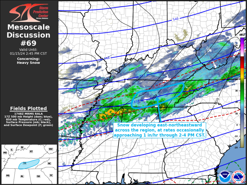
Mesoscale Discussion 0069
NWS Storm Prediction Center Norman OK
1150 AM CST Mon Jan 15 2024

Areas affected...parts of middle and eastern Tennessee

Concerning...Heavy snow

Valid 151750Z - 152045Z

SUMMARY...An area of heavier snow rates, occasionally approaching 1
inch per hour, may be maintained east-northeastward across portions
of middle and eastern Tennessee through 2-4 PM CST, before gradually
diminishing through early evening.

DISCUSSION...A mid-level speed maximum propagating across northern
Mississippi is forecast to reach the Cumberland Plateau by early
evening.  This  still appears associated with an area of enhanced
mid/upper forcing for ascent, which might be maintained through the
20-22Z time frame while overspreading portions of middle through
eastern Tennessee.  Thereafter, frontogenetic forcing is forecast to
generally weaken across the Tennessee Valley through southern
Appalachians vicinity, yielding diminishing precipitation rates.
Until then, it appears that the area of enhanced lift will include
upward vertical motion maximized within the favorably cold mid-level
layer (centered around or above 600 mb) for large dendritic ice
crystal growth.  It appears this may remain strong enough to support
continuing potential for occasional heavy snow rates up to around 1
inch per hour, where lower/mid tropospheric profiles are maintained
at or below freezing (roughly north of the 0 C isotherm at 859 mb).

..Kerr.. 01/15/2024

...Please see www.spc.noaa.gov for graphic product...

ATTN...WFO...MRX...OHX...HUN...

LAT...LON   34978743 35118584 35718402 36408364 36298463 36048579
            35848708 34978743
https://www.spc.noaa.gov/products/md/md0069.html Save to Pocket
date: 2024-01-15, from: NOAA tornado/severe thunderstorm watches, mesoscale discussions, convective outlooks, fire weather outlooks

Mesoscale Discussion 0068
NWS Storm Prediction Center Norman OK
1117 AM CST Mon Jan 15 2024

Areas affected...Louisiana into Mississippi and northern Alabama

Concerning...Winter mixed precipitation

Valid 151717Z - 152115Z

SUMMARY...A wintry mix of snow, sleet, and freezing rain is expected
to spread east from southeast Arkansas and northern Louisiana into
Mississippi and northern Alabama through early afternoon.

DISCUSSION...Surface observations, LSRs, and MPING reports over the
past 1-2 hours continue to show a mix of snow, sleet, and freezing
rain from the ArkLaTex region into northern MS/AL within a broad
precipitation swath. Isentropic ascent over a 925-850 mb frontal
zone is forecast to persist through early afternoon as a
low-amplitude wave, currently over the southern Plains, migrates
east. Recent sleet LSRs and forecast soundings suggest that a mix of
snow and sleet will be more likely where surface temperatures are in
the low 20s or lower. Areas where temperatures are in the mid-20s or
higher should have too shallow/warm of a sub-freezing layer to
support much re-freezing of hydrometeors, making a sleet/freezing
rain mix more probable. Forecast guidance suggests that
precipitation intensity may gradually wane heading into the
mid-afternoon hours, but a zone of impactful wintry precipitation
appears probable prior to this occurring.

..Moore.. 01/15/2024

...Please see www.spc.noaa.gov for graphic product...

ATTN...WFO...BMX...HUN...MEG...JAN...LZK...SHV...

LAT...LON   32389370 32969267 34238987 34948780 34978610 34718575
            34368570 33158810 32298989 31939125 31739213 31609304
            31669354 31849381 32109389 32389370
https://www.spc.noaa.gov/products/md/md0068.html Save to Pocket
date: 2024-01-14, from: NOAA tornado/severe thunderstorm watches, mesoscale discussions, convective outlooks, fire weather outlooks

Mesoscale Discussion 0063
NWS Storm Prediction Center Norman OK
1049 AM CST Sun Jan 14 2024

Areas affected...Southeast New York into the New England region

Concerning...Snow Squall

Valid 141649Z - 142045Z

SUMMARY...Thermodynamic conditions will remain favorable for snow
squalls as a cold front pushes east into the New England region.

DISCUSSION...Recent regional radar depicts broken bands of shallow
convection along an eastward moving cold front from upstate NY into
eastern PA. Visibility reductions between 1/4 to 1 mile have been
observed with the passage of these bands and are primarily being
driven by bursts of moderate to heavy snow with 25-35 mph wind
gusts. The 12 UTC PIT sounding likely sampled the convective
environment most accurately with nearly dry adiabatic lapse rates
from the surface to ~750 mb, which appears to be represented well by
recent 0-3 km lapse rate analyses. The plume of 8+ C/km low-level
lapse rates is forecast to spread to the northeast into the New
England region through the day in tandem with the cooler mid-level
temperatures associated with the primary trough axis. Low-level
instability should be bolstered by modest diurnal heating between
cloud breaks through the afternoon, and a weak influx of moisture
may support occasional lightning flashes, though sustained,
lightning-producing convection is not necessarily anticipated.
Nonetheless, the combination of improving low-level thermodynamics,
focused ascent along the front, and 30-40 mph winds within the
boundary layer should maintain the snow squall potential well into
the afternoon.

..Moore.. 01/14/2024

...Please see www.spc.noaa.gov for graphic product...

ATTN...WFO...GYX...BOX...BTV...OKX...ALY...PHI...BGM...

LAT...LON   40817558 41267567 42257496 44237351 44587283 44747124
            44797089 44607048 44146998 43776984 43257045 42577077
            41467167 41237225 41187286 40497484 40817558
https://www.spc.noaa.gov/products/md/md0063.html Save to Pocket