(date: 2024-04-05 08:54:36)
date: 2024-04-05, from: NOAA tornado/severe thunderstorm watches, mesoscale discussions, convective outlooks, fire weather outlooks
No watches are valid as of Fri Apr 5 14:02:01 UTC 2024.
https://www.spc.noaa.gov/products/watch/
date: 2024-04-05, from: NOAA tornado/severe thunderstorm watches, mesoscale discussions, convective outlooks, fire weather outlooks
No Mesoscale Discussions are in effect as of Fri Apr 5 14:02:01 UTC 2024.
https://www.spc.noaa.gov/products/md/
date: 2024-04-05, from: NOAA tornado/severe thunderstorm watches, mesoscale discussions, convective outlooks, fire weather outlooks

Day 1 Convective Outlook
NWS Storm Prediction Center Norman OK
0710 AM CDT Fri Apr 05 2024

Valid 051300Z - 061200Z

...NO SEVERE THUNDERSTORM AREAS FORECAST...

...SUMMARY...
Severe thunderstorms are not expected today or tonight.

...Synopsis...
Water-vapor imagery early this morning shows a mid to upper-level
low over northern CA and an associated large-scale trough over the
West Coast.  A mid-level ridge is downstream over the Great Plains
to the west of a large-scale trough/mid-level low near the East
Coast.  The western U.S. trough/low will gradually pivot east
through Saturday morning across the Desert Southwest and Great
Basin.  Isolated thunderstorms are possible across CA/NV/AZ in
conjunction with increasing large-scale ascent and sporadic pockets
of weak buoyancy.  Isolated thunderstorms are also possible across
the central and northern Rockies and adjacent plains.  Strong gusts
cannot be ruled out with a few thunderstorms, but limited buoyancy
will likely preclude the development of severe thunderstorms through
tonight.

..Smith/Wendt.. 04/05/2024
https://www.spc.noaa.gov/products/outlook/day1otlk_1300.html
date: 2024-04-05, from: NOAA Weather Forecasts
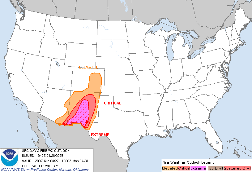
Day 2 Fire Weather Outlook
NWS Storm Prediction Center Norman OK
0203 AM CDT Fri Apr 05 2024

Valid 061200Z - 071200Z

...CRITICAL FIRE WEATHER AREA FOR THE SOUTHERN HIGH PLAINS...

...Synopsis...
The second of a two-day fire weather event is anticipated on
Saturday across southern NM/far west TX to southeast CO and
southwest KS. Robust lee cyclogenesis is anticipated across the
central High Plains by 18 UTC Saturday as a progressive upper-level
wave (currently moving onto the CA coast) overspreads the region.
The surface low is forecast to shift east into the Plains through
the afternoon with a trailing surface trough/Pacific front pushing
east across the southern High Plains by late morning. As this
occurs, west/northwesterly post-frontal winds will advect a dry air
mass off the central/southern Rockies into the High Plains.
Downslope warming/drying of this air mass will promote widespread RH
reductions into the 10-20% range across NM, western TX, and portions
of OK/CO/KS. Latest high-res ensemble guidance shows reasonably high
confidence in sub-15% RH within the critical risk area, and the
typically drier/windier solutions hint that single-digit RH minimums
are possible.

Winds are expected to increase to 20-25 mph (gusting to 40-50 mph)
by early afternoon amid a strengthening surface pressure gradient
and deepening boundary-layer mixing. Sustained winds between 30-35
mph winds possible under the mid-level jet maximum, which should be
located broadly across the northern TX and OK Panhandles. This
region will see the highest potential for extremely critical fire
weather conditions. Consideration was given to introducing an
Extremely Critical risk area, but somewhat low ensemble consensus
for sustained 30+ mph winds (only 10-30% probability) precluded
higher risk headlines. These low probabilities may be associated
with spread regarding the placement and magnitude of the surface low
(up to a 4 mb difference between some solutions). These details
should become better resolved heading into the Day-1 time frame.
Regardless, fuels across the region should be very receptive after
warm, dry, and windy conditions on Friday, which should support the
high-end Critical fire weather risk on Saturday.

..Moore.. 04/05/2024

...Please see www.spc.noaa.gov/fire for graphic product...
https://www.spc.noaa.gov/products/fire_wx/fwdy2.html
date: 2024-04-04, from: NOAA tornado/severe thunderstorm watches, mesoscale discussions, convective outlooks, fire weather outlooks

Day 1 Fire Weather Outlook
NWS Storm Prediction Center Norman OK
1131 AM CDT Thu Apr 04 2024

Valid 041700Z - 051200Z

...NO CRITICAL AREAS...

The previous forecast (see below) remains on track. Additionally,
locally elevated fire-weather conditions are possible this afternoon
across portions of the Southeast, that have missed out on
appreciable rainfall over the last 1-2 weeks. This includes parts of
far southern MS, southern AL, and the far western FL Panhandle.
Here, diurnal heating will contribute to 20-30 percent afternoon RH,
coincident with breezy/gusty post-frontal winds (sustained around 15
mph). While these conditions would ordinarily warrant Elevated
highlights, fuels generally do not appear supportive of large-fire
potential.

..Weinman.. 04/04/2024

.PREV DISCUSSION... /ISSUED 1256 AM CDT Thu Apr 04 2024/

...Synopsis...
A strong mid-level trough will amplify across the West Coast today.
Ahead of this trough, moderate to strong mid-level flow will
overspread a deeply mixed airmass in Arizona and the Great Basin.
This will result in dry and breezy conditions across a broad region.
However, fuels remain moist in this area and therefore, the fire
weather threat will be minimal.

...Please see www.spc.noaa.gov/fire for graphic product...
https://www.spc.noaa.gov/products/fire_wx/fwdy1.html
date: 2024-04-04, from: NOAA tornado/severe thunderstorm watches, mesoscale discussions, convective outlooks, fire weather outlooks

Day 1 Convective Outlook
NWS Storm Prediction Center Norman OK
1125 AM CDT Thu Apr 04 2024

Valid 041630Z - 051200Z

...THERE IS A MARGINAL RISK OF SEVERE THUNDERSTORMS THIS
AFTERNOON/EVENING FROM ID INTO WESTERN MT...

...SUMMARY...
Isolated, marginally severe hail and wind will be possible this
afternoon/evening from Idaho into western Montana.

...Synopsis...
A highly amplified pattern will persist over the CONUS through
Friday morning, with a deep midlevel trough moving slowly inland
over the Pacific coast, and a separate/deep low making gradual
eastward progress over the Mid-Atlantic/southern New England.  Cold
midlevel temperatures and resulting conditionally unstable
low-midlevel lapse rates will result in weak buoyancy and low-topped
convection/isolated lightning flashes today from the upper OH Valley
into the Mid-Atlantic.  Out west, there will be some potential for a
strong storm or two along the more north-south front across western
ID and up to an east-west frontal segment across western MT.
Profiles are closer to saturated today compared to yesterday at
BOI/TFX, and associated clouds will tend to slow surface heating
along and east-through-south of the frontal segments.  Still, there
will be enough buoyancy for a low-end wind/hail threat, given strong
deep-layer, south-southwesterly shear/long hodographs.

..Thompson/Kerr.. 04/04/2024
https://www.spc.noaa.gov/products/outlook/day1otlk_1630.html
date: 2024-04-03, from: NOAA tornado/severe thunderstorm watches, mesoscale discussions, convective outlooks, fire weather outlooks
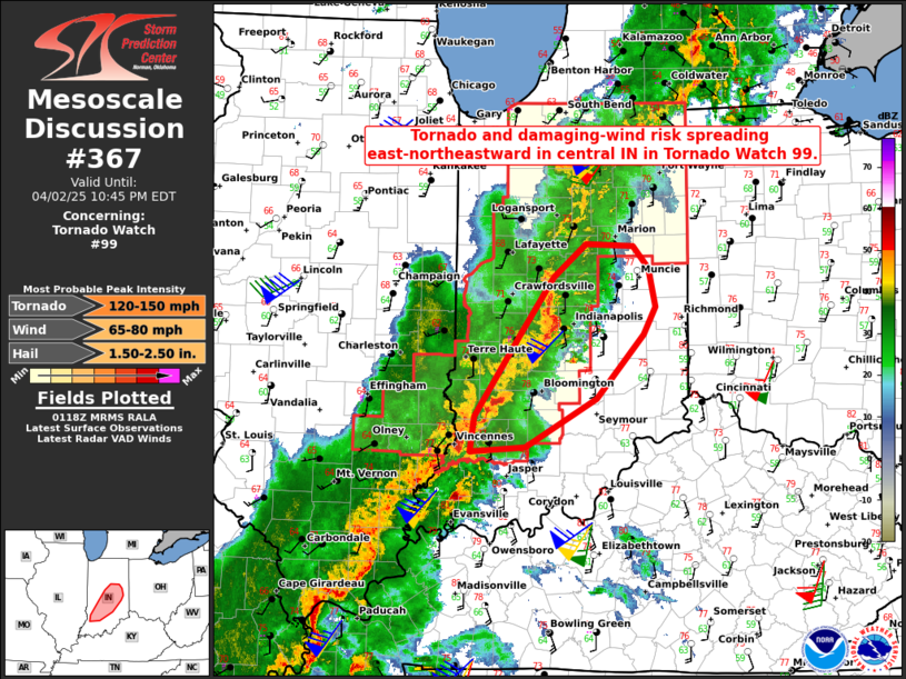
Mesoscale Discussion 0367
NWS Storm Prediction Center Norman OK
0905 AM CDT Wed Apr 03 2024

Areas affected...Portions of north FL and extreme southeast GA

Concerning...Tornado Watch 85...

Valid 031405Z - 031530Z

The severe weather threat for Tornado Watch 85 continues.

SUMMARY...An isolated damaging wind and tornado threat may continue
across parts of north FL. A local extension in area of Tornado Watch
85 is possible. Or, a new downstream Watch could be issued.

DISCUSSION...A cluster/loosely organized line of convection is
ongoing across north FL and far southeast GA this morning ahead of a
cold front. While the 12Z sounding from JAX showed substantial
capping/inhibition and visible satellite indicates some anvil
shading, continued diurnal heating of the moist low-level airmass
ahead of the line of thunderstorms should help gradually erode most
of the remaining MLCIN. Weak instability will likely be sufficient
to maintain convective structure and intensity given ample low-level
and deep-layer shear present on recent VWPs from KJAX. With around
200-250 m2/s2 of 0-1 km SRH present, embedded updraft rotation
within the line should continue to pose some threat for a few
tornadoes through the rest of the morning and perhaps into the
afternoon, as convection spreads east-southeastward across the north
FL Peninsula. Occasional damaging winds will also remain a concern
as low-level lapse rates gradually steepen. A local extension in
area of Tornado Watch 85, or a new downstream Watch, will need to be
considered for parts of north FL.

..Gleason.. 04/03/2024

...Please see www.spc.noaa.gov for graphic product...

ATTN...WFO...MLB...TBW...JAX...TAE...

LAT...LON   29608366 30278296 30698203 30648150 30248135 29828117
            29218095 28718191 28768270 29288357 29608366
https://www.spc.noaa.gov/products/md/md0367.html
date: 2024-04-03, from: NOAA tornado/severe thunderstorm watches, mesoscale discussions, convective outlooks, fire weather outlooks
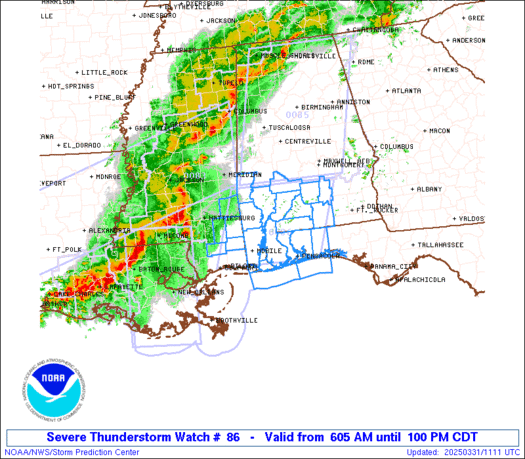
STATUS REPORT ON WW 62

SEVERE WEATHER THREAT CONTINUES RIGHT OF A LINE FROM 40 E LFT TO
20 SSW MCB TO 30 NNW PIB TO 15 W MEI TO 40 S CBM TO 20 ESE CBM.

..LEITMAN..03/26/24

ATTN...WFO...JAN...LIX...


STATUS REPORT FOR WT 62

SEVERE WEATHER THREAT CONTINUES FOR THE FOLLOWING AREAS

LAC063-103-105-117-260640-

LA
.    LOUISIANA PARISHES INCLUDED ARE

LIVINGSTON           ST. TAMMANY         TANGIPAHOA
WASHINGTON


MSC023-031-035-061-065-067-069-073-075-091-103-109-147-260640-

MS
.    MISSISSIPPI COUNTIES INCLUDED ARE

CLARKE               COVINGTON           FORREST
JASPER               JEFFERSON DAVIS     JONES
KEMPER               LAMAR               LAUDERDALE
MARION               NOXUBEE             PEARL RIVER
WALTHALL


THE WATCH STATUS MESSAGE IS FOR GUIDANCE PURPOSES ONLY.  PLEASE
REFER TO WATCH COUNTY NOTIFICATION STATEMENTS FOR OFFICIAL
INFORMATION ON COUNTIES...INDEPENDENT CITIES AND MARINE ZONES
CLEARED FROM SEVERE THUNDERSTORM AND TORNADO WATCHES.
https://www.spc.noaa.gov/products/watch/ws0086.html
date: 2024-04-03, from: NOAA tornado/severe thunderstorm watches, mesoscale discussions, convective outlooks, fire weather outlooks

URGENT - IMMEDIATE BROADCAST REQUESTED
Tornado Watch Number 86
NWS Storm Prediction Center Norman OK
1040 AM EDT Wed Apr 3 2024

The NWS Storm Prediction Center has issued a

* Tornado Watch for portions of
  North and central Florida
  Coastal Waters

* Effective this Wednesday morning and afternoon from 1040 AM
  until 500 PM EDT.

* Primary threats include...
  A couple tornadoes possible
  Isolated damaging wind gusts to 70 mph possible

SUMMARY...A pre-frontal band of thunderstorms will continue to
develop slowly southeastward from north into central Florida through
the afternoon.  Embedded storms will be capable of producing
damaging winds of 60-70 mph, while the potential for a couple of
tornadoes will be greater with any isolated supercells that can form
just ahead of the main line of storms.

The tornado watch area is approximately along and 60 statute miles
north and south of a line from 60 miles south southwest of Cross
City FL to 25 miles east of St Augustine FL. For a complete
depiction of the watch see the associated watch outline update
(WOUS64 KWNS WOU6).

PRECAUTIONARY/PREPAREDNESS ACTIONS...

REMEMBER...A Tornado Watch means conditions are favorable for
tornadoes and severe thunderstorms in and close to the watch
area. Persons in these areas should be on the lookout for
threatening weather conditions and listen for later statements
and possible warnings.

&&

OTHER WATCH INFORMATION...CONTINUE...WW 85...

AVIATION...Tornadoes and a few severe thunderstorms with hail
surface and aloft to 0.5 inches. Extreme turbulence and surface wind
gusts to 60 knots. A few cumulonimbi with maximum tops to 500. Mean
storm motion vector 25040.

...Thompson
https://www.spc.noaa.gov/products/watch/ww0086.html
date: 2024-04-03, from: NOAA tornado/severe thunderstorm watches, mesoscale discussions, convective outlooks, fire weather outlooks
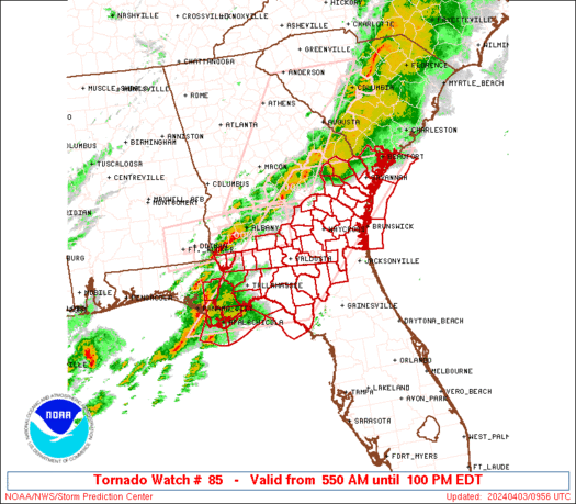
STATUS REPORT ON WW 85

SEVERE WEATHER THREAT CONTINUES RIGHT OF A LINE FROM 55 WSW CTY
TO 20 NNE CTY TO 30 ENE AYS TO 35 SSW SAV TO 45 SE SAV.

FOR ADDITIONAL INFORMATION SEE MESOSCALE DISCUSSION 0367

..GLEASON..04/03/24

ATTN...WFO...JAX...TAE...CHS...


STATUS REPORT FOR WT 85

SEVERE WEATHER THREAT CONTINUES FOR THE FOLLOWING AREAS

FLC003-023-029-031540-

FL
.    FLORIDA COUNTIES INCLUDED ARE

BAKER                COLUMBIA            DIXIE


GAC025-039-049-127-191-305-031540-

GA
.    GEORGIA COUNTIES INCLUDED ARE

BRANTLEY             CAMDEN              CHARLTON
GLYNN                MCINTOSH            WAYNE


AMZ354-450-GMZ765-031540-

CW

.    ADJACENT COASTAL WATERS INCLUDED ARE
https://www.spc.noaa.gov/products/watch/ws0085.html
date: 2024-04-03, from: NOAA tornado/severe thunderstorm watches, mesoscale discussions, convective outlooks, fire weather outlooks

URGENT - IMMEDIATE BROADCAST REQUESTED
Tornado Watch Number 85
NWS Storm Prediction Center Norman OK
550 AM EDT Wed Apr 3 2024

The NWS Storm Prediction Center has issued a

* Tornado Watch for portions of
  Florida Panhandle
  Southern Georgia
  Southern South Carolina
  Coastal Waters

* Effective this Wednesday morning and afternoon from 550 AM
  until 100 PM EDT.

* Primary threats include...
  A couple tornadoes possible
  Scattered damaging wind gusts to 70 mph possible
  Isolated large hail events to 1.5 inches in diameter possible

SUMMARY...Several broken bands of thunderstorms will continue to
move generally west to east across the Watch area this morning.
Scattered strong to severe thunderstorms embedded within the larger
thunderstorm clusters will pose a risk for damaging gusts and
possibly a couple of tornadoes.

The tornado watch area is approximately along and 85 statute miles
east and west of a line from 30 miles north northwest of Savannah GA
to 35 miles east southeast of Apalachicola FL. For a complete
depiction of the watch see the associated watch outline update
(WOUS64 KWNS WOU5).

PRECAUTIONARY/PREPAREDNESS ACTIONS...

REMEMBER...A Tornado Watch means conditions are favorable for
tornadoes and severe thunderstorms in and close to the watch
area. Persons in these areas should be on the lookout for
threatening weather conditions and listen for later statements
and possible warnings.

&&

OTHER WATCH INFORMATION...CONTINUE...WW 83...WW 84...

AVIATION...Tornadoes and a few severe thunderstorms with hail
surface and aloft to 1.5 inches. Extreme turbulence and surface wind
gusts to 60 knots. A few cumulonimbi with maximum tops to 500. Mean
storm motion vector 25040.

...Smith
https://www.spc.noaa.gov/products/watch/ww0085.html
date: 2024-04-03, from: NOAA tornado/severe thunderstorm watches, mesoscale discussions, convective outlooks, fire weather outlooks
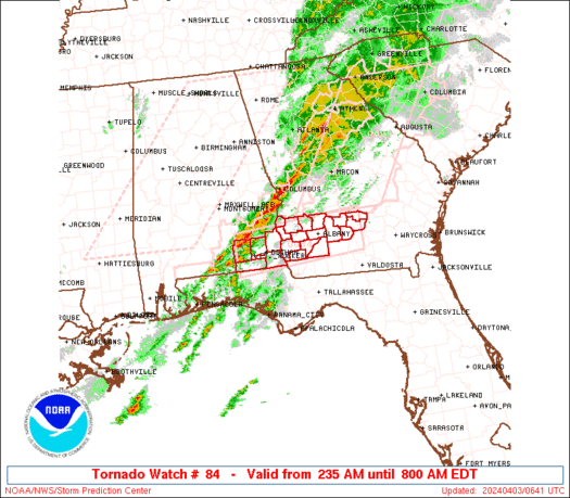
STATUS REPORT ON WW 84

SEVERE WEATHER THREAT CONTINUES RIGHT OF A LINE FROM 15 NE MAI TO
55 ENE ABY.

..LEITMAN..04/03/24

ATTN...WFO...TAE...


STATUS REPORT FOR WT 84

SEVERE WEATHER THREAT CONTINUES FOR THE FOLLOWING AREAS

GAC007-017-155-201-205-277-287-321-031140-

GA
.    GEORGIA COUNTIES INCLUDED ARE

BAKER                BEN HILL            IRWIN
MILLER               MITCHELL            TIFT
TURNER               WORTH


THE WATCH STATUS MESSAGE IS FOR GUIDANCE PURPOSES ONLY.  PLEASE
REFER TO WATCH COUNTY NOTIFICATION STATEMENTS FOR OFFICIAL
INFORMATION ON COUNTIES...INDEPENDENT CITIES AND MARINE ZONES
CLEARED FROM SEVERE THUNDERSTORM AND TORNADO WATCHES.
https://www.spc.noaa.gov/products/watch/ws0084.html
date: 2024-04-03, from: NOAA tornado/severe thunderstorm watches, mesoscale discussions, convective outlooks, fire weather outlooks
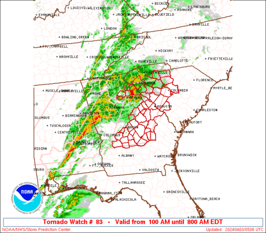
STATUS REPORT ON WW 83

SEVERE WEATHER THREAT CONTINUES RIGHT OF A LINE FROM 50 ENE ABY
TO 30 NNW VDI TO 40 S AGS TO 45 S AGS.

..LEITMAN..04/03/24

ATTN...WFO...FFC...CAE...GSP...


STATUS REPORT FOR WT 83

SEVERE WEATHER THREAT CONTINUES FOR THE FOLLOWING AREAS

GAC091-107-175-209-271-279-283-309-031140-

GA
.    GEORGIA COUNTIES INCLUDED ARE

DODGE                EMANUEL             LAURENS
MONTGOMERY           TELFAIR             TOOMBS
TREUTLEN             WHEELER


THE WATCH STATUS MESSAGE IS FOR GUIDANCE PURPOSES ONLY.  PLEASE
REFER TO WATCH COUNTY NOTIFICATION STATEMENTS FOR OFFICIAL
INFORMATION ON COUNTIES...INDEPENDENT CITIES AND MARINE ZONES
CLEARED FROM SEVERE THUNDERSTORM AND TORNADO WATCHES.
https://www.spc.noaa.gov/products/watch/ws0083.html
date: 2024-04-02, from: NOAA tornado/severe thunderstorm watches, mesoscale discussions, convective outlooks, fire weather outlooks

Mesoscale Discussion 0344
NWS Storm Prediction Center Norman OK
0959 AM CDT Tue Apr 02 2024

Areas affected...Portions of WV

Concerning...Tornado Watch 74...

Valid 021459Z - 021630Z

The severe weather threat for Tornado Watch 74 continues.

SUMMARY...A substantial severe wind threat (70-90+ mph gusts), along
with isolated tornadoes, will approach Charleston West Virginia and
vicinity through noon.

DISCUSSION...KHTS recently measured a significant severe wind gust
to 80 kt (92 mph) with a compact but well organized cluster
currently moving quickly eastward across parts of WV. Even though
the airmass across this region remains only weakly unstable, very
strong low-level and deep-layer shear is helping to compensate and
provide convective organization. Recent radar data from KRLX shows
enhanced inbound velocities embedded within the line that suggest
70-90+ mph wind gusts will likely continue to be a threat with this
line as it approaches the Charleston WV metro and vicinity over the
next hour (through noon EDT). In addition to this substantial
severe/damaging wind threat, isolated tornadoes embedded within the
line also appear possible given the strength of the low-level flow
and related shear.

..Gleason.. 04/02/2024

...Please see www.spc.noaa.gov for graphic product...

ATTN...WFO...RNK...RLX...JKL...

LAT...LON   38688203 38658123 38328078 37838091 37478126 37528198
            37928258 38288217 38688203
https://www.spc.noaa.gov/products/md/md0344.html
date: 2024-04-02, from: NOAA tornado/severe thunderstorm watches, mesoscale discussions, convective outlooks, fire weather outlooks
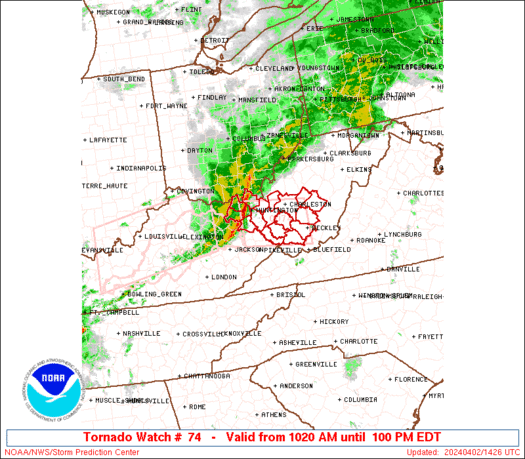
STATUS REPORT ON WW 74

SEVERE WEATHER THREAT CONTINUES RIGHT OF A LINE FROM 25 E JKL TO
35 SE HTS TO 15 SSW CRW TO 5 NNW CRW TO 20 SSW PKB.

FOR ADDITIONAL INFORMATION SEE MESOSCALE DISCUSSION 0344

..GLEASON..04/02/24

ATTN...WFO...RLX...


STATUS REPORT FOR WT 74

SEVERE WEATHER THREAT CONTINUES FOR THE FOLLOWING AREAS

WVC005-007-013-015-019-021-035-039-041-045-059-067-075-081-083-
087-097-101-109-021640-

WV
.    WEST VIRGINIA COUNTIES INCLUDED ARE

BOONE                BRAXTON             CALHOUN
CLAY                 FAYETTE             GILMER
JACKSON              KANAWHA             LEWIS
LOGAN                MINGO               NICHOLAS
POCAHONTAS           RALEIGH             RANDOLPH
ROANE                UPSHUR              WEBSTER
WYOMING


THE WATCH STATUS MESSAGE IS FOR GUIDANCE PURPOSES ONLY.  PLEASE
REFER TO WATCH COUNTY NOTIFICATION STATEMENTS FOR OFFICIAL
INFORMATION ON COUNTIES...INDEPENDENT CITIES AND MARINE ZONES
CLEARED FROM SEVERE THUNDERSTORM AND TORNADO WATCHES.
https://www.spc.noaa.gov/products/watch/ws0074.html
date: 2024-04-02, from: NOAA tornado/severe thunderstorm watches, mesoscale discussions, convective outlooks, fire weather outlooks

URGENT - IMMEDIATE BROADCAST REQUESTED
Tornado Watch Number 74
NWS Storm Prediction Center Norman OK
1020 AM EDT Tue Apr 2 2024

The NWS Storm Prediction Center has issued a

* Tornado Watch for portions of
  Extreme northeast Kentucky
  Extreme southern Ohio
  Southern West Virginia

* Effective this Tuesday morning and afternoon from 1020 AM until
  100 PM EDT.

* Primary threats include...
  A couple tornadoes possible
  Scattered damaging wind gusts to 70 mph likely
  Isolated large hail events to 1 inch in diameter possible

SUMMARY...A well-developed squall line may persist for a few more
hours as it moves from Kentucky into West Virginia this morning.
Damaging gusts of 60-70 mph and a couple of tornadoes with embedded
circulations will be possible.

The tornado watch area is approximately along and 35 statute miles
north and south of a line from 25 miles southwest of Huntington WV
to 10 miles north northeast of Beckley WV. For a complete depiction
of the watch see the associated watch outline update (WOUS64 KWNS
WOU4).

PRECAUTIONARY/PREPAREDNESS ACTIONS...

REMEMBER...A Tornado Watch means conditions are favorable for
tornadoes and severe thunderstorms in and close to the watch
area. Persons in these areas should be on the lookout for
threatening weather conditions and listen for later statements
and possible warnings.

&&

OTHER WATCH INFORMATION...CONTINUE...WW 73...

AVIATION...Tornadoes and a few severe thunderstorms with hail
surface and aloft to 1 inch. Extreme turbulence and surface wind
gusts to 60 knots. A few cumulonimbi with maximum tops to 450. Mean
storm motion vector 28050.

...Thompson
https://www.spc.noaa.gov/products/watch/ww0074.html
date: 2024-04-02, from: NOAA tornado/severe thunderstorm watches, mesoscale discussions, convective outlooks, fire weather outlooks
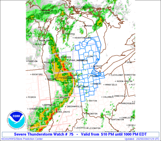
STATUS REPORT ON WW 75

THE SEVERE WEATHER THREAT CONTINUES ACROSS THE ENTIRE WATCH AREA.

..GLEASON..04/02/24

ATTN...WFO...LMK...PAH...OHX...MEG...


STATUS REPORT FOR WT 75

SEVERE WEATHER THREAT CONTINUES FOR THE FOLLOWING AREAS

KYC001-003-009-035-045-047-053-057-087-099-137-141-169-171-207-
213-217-219-221-227-021640-

KY
.    KENTUCKY COUNTIES INCLUDED ARE

ADAIR                ALLEN               BARREN
CALLOWAY             CASEY               CHRISTIAN
CLINTON              CUMBERLAND          GREEN
HART                 LINCOLN             LOGAN
METCALFE             MONROE              RUSSELL
SIMPSON              TAYLOR              TODD
TRIGG                WARREN


TNC003-005-015-017-021-023-027-031-035-037-039-041-043-049-055-
061-071-077-079-081-083-085-087-099-101-109-111-117-119-125-133-
135-137-141-147-149-159-161-165-169-175-177-181-183-185-187-189-
021640-

TN
.    TENNESSEE COUNTIES INCLUDED ARE

BEDFORD              BENTON              CANNON
CARROLL              CHEATHAM            CHESTER
CLAY                 COFFEE              CUMBERLAND
https://www.spc.noaa.gov/products/watch/ws0075.html
date: 2024-04-02, from: NOAA tornado/severe thunderstorm watches, mesoscale discussions, convective outlooks, fire weather outlooks

URGENT - IMMEDIATE BROADCAST REQUESTED
Tornado Watch Number 75
NWS Storm Prediction Center Norman OK
950 AM CDT Tue Apr 2 2024

The NWS Storm Prediction Center has issued a

* Tornado Watch for portions of
  Southern Kentucky
  Western and middle Tennessee

* Effective this Tuesday morning and afternoon from 950 AM until
  300 PM CDT.

* Primary threats include...
  A few tornadoes likely with a couple intense tornadoes possible
  Widespread damaging winds and isolated significant gusts to 75
    mph likely
  Scattered large hail events to 1.5 inches in diameter likely

SUMMARY...A loose cluster of storms in western Tennessee is expected
to evolve into a couple of supercells while spreading
east-northeastward toward southern Kentucky and middle Tennessee
through midday and early afternoon.  The environment ahead of the
storms will be favorable for tornadoes, a couple of which could be
strong (roughly EF2), as well as damaging gusts up to 75 mph and
large hail of 1-1.5 inches in diameter.

The tornado watch area is approximately along and 50 statute miles
north and south of a line from 20 miles north of Jackson TN to 45
miles north of Crossville TN. For a complete depiction of the watch
see the associated watch outline update (WOUS64 KWNS WOU5).

PRECAUTIONARY/PREPAREDNESS ACTIONS...

REMEMBER...A Tornado Watch means conditions are favorable for
tornadoes and severe thunderstorms in and close to the watch
area. Persons in these areas should be on the lookout for
threatening weather conditions and listen for later statements
and possible warnings.

&&

OTHER WATCH INFORMATION...CONTINUE...WW 73...WW 74...

AVIATION...Tornadoes and a few severe thunderstorms with hail
surface and aloft to 1.5 inches. Extreme turbulence and surface wind
gusts to 65 knots. A few cumulonimbi with maximum tops to 500. Mean
storm motion vector 24050.

...Thompson
https://www.spc.noaa.gov/products/watch/ww0075.html
date: 2024-04-02, from: NOAA tornado/severe thunderstorm watches, mesoscale discussions, convective outlooks, fire weather outlooks
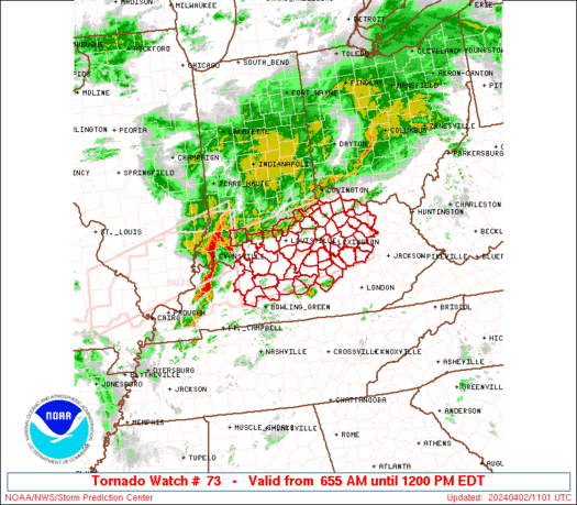
STATUS REPORT ON WW 73

SEVERE WEATHER THREAT CONTINUES RIGHT OF A LINE FROM 60 WNW LOZ
TO 20 S LEX TO 35 NW JKL TO 55 N JKL.

FOR ADDITIONAL INFORMATION SEE MESOSCALE DISCUSSION 0343

..GLEASON..04/02/24

ATTN...WFO...LMK...JKL...ILN...


STATUS REPORT FOR WT 73

SEVERE WEATHER THREAT CONTINUES FOR THE FOLLOWING AREAS

KYC045-063-065-079-137-151-153-165-175-197-205-237-021540-

KY
.    KENTUCKY COUNTIES INCLUDED ARE

CASEY                ELLIOTT             ESTILL
GARRARD              LINCOLN             MADISON
MAGOFFIN             MENIFEE             MORGAN
POWELL               ROWAN               WOLFE


THE WATCH STATUS MESSAGE IS FOR GUIDANCE PURPOSES ONLY.  PLEASE
REFER TO WATCH COUNTY NOTIFICATION STATEMENTS FOR OFFICIAL
INFORMATION ON COUNTIES...INDEPENDENT CITIES AND MARINE ZONES
CLEARED FROM SEVERE THUNDERSTORM AND TORNADO WATCHES.
https://www.spc.noaa.gov/products/watch/ws0073.html
date: 2024-04-02, from: NOAA tornado/severe thunderstorm watches, mesoscale discussions, convective outlooks, fire weather outlooks

STATUS REPORT ON WW 72

SEVERE WEATHER THREAT CONTINUES RIGHT OF A LINE FROM 30 N HOP TO
10 WNW OWB TO 25 ENE EVV TO 40 NE EVV TO 40 SSW BMG.

..LEITMAN..04/02/24

ATTN...WFO...ILX...PAH...IND...


STATUS REPORT FOR WT 72

SEVERE WEATHER THREAT CONTINUES FOR THE FOLLOWING AREAS

INC147-021240-

IN
.    INDIANA COUNTIES INCLUDED ARE

SPENCER


KYC059-107-149-177-021240-

KY
.    KENTUCKY COUNTIES INCLUDED ARE

DAVIESS              HOPKINS             MCLEAN
MUHLENBERG


THE WATCH STATUS MESSAGE IS FOR GUIDANCE PURPOSES ONLY.  PLEASE
REFER TO WATCH COUNTY NOTIFICATION STATEMENTS FOR OFFICIAL
INFORMATION ON COUNTIES...INDEPENDENT CITIES AND MARINE ZONES
CLEARED FROM SEVERE THUNDERSTORM AND TORNADO WATCHES.