(date: 2024-04-26 08:51:08)
date: 2024-04-26, from: NOAA tornado/severe thunderstorm watches, mesoscale discussions, convective outlooks, fire weather outlooks

Mesoscale Discussion 0525
NWS Storm Prediction Center Norman OK
0933 AM CDT Fri Apr 26 2024

Areas affected...central northeast Texas

Concerning...Severe potential...Watch possible

Valid 261433Z - 261700Z

Probability of Watch Issuance...60 percent

SUMMARY...Scattered storms are likely to form throughout the day,
and some are likely to become severe with tornado and large hail
potential. A watch may be needed by midday.

DISCUSSION...The morning FWD sounding shows a deep moist layer early
this morning, with 50 kt winds below 850 mb resulting in strong
low-level shear. Satellite imagery shows broken to overcast
conditions over much of central TX, with scattered to broken over
much of northern TX, leading to areas of heating.

The very moist air mass is already aiding early development of
storms between Austin and Stephenville, and indications are that
this activity will gradually increase during the day beneath a
persistent low-level jet. This will lead to a long duration of
moist, unstable and sheared environment, with a few supercells
likely within the developing cluster of warm sector storms, leading
to a developing tornado risk as the activity spreads toward
northeast TX.

..Jewell/Hart.. 04/26/2024

...Please see www.spc.noaa.gov for graphic product...

ATTN...WFO...SHV...TSA...HGX...FWD...OUN...

LAT...LON   31109646 31039777 31339853 31749866 32329848 32719829
            33129802 33729636 33949543 33859483 33749425 33609404
            33349396 32859407 32099463 31799507 31109646
https://www.spc.noaa.gov/products/md/md0525.html
date: 2024-04-26, from: NOAA tornado/severe thunderstorm watches, mesoscale discussions, convective outlooks, fire weather outlooks
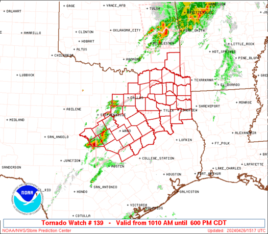
STATUS FOR WATCH 0139 HAS NOT BEEN ISSUED YET
https://www.spc.noaa.gov/products/watch/ws0139.html
date: 2024-04-26, from: NOAA tornado/severe thunderstorm watches, mesoscale discussions, convective outlooks, fire weather outlooks

URGENT - IMMEDIATE BROADCAST REQUESTED
Tornado Watch Number 139
NWS Storm Prediction Center Norman OK
1010 AM CDT Fri Apr 26 2024

The NWS Storm Prediction Center has issued a

* Tornado Watch for portions of
  Southeast Oklahoma
  Central and Northeast Texas

* Effective this Friday morning and evening from 1010 AM until
  600 PM CDT.

* Primary threats include...
  A few tornadoes possible
  Scattered large hail and isolated very large hail events to 2.5
    inches in diameter possible
  Scattered damaging wind gusts to 70 mph possible

SUMMARY...Thunderstorms are expected increase in coverage and
intensity through the late morning and afternoon, with a few severe
thunderstorms possible.  Large hail, damaging winds, and a few
tornadoes may occur.

The tornado watch area is approximately along and 60 statute miles
north and south of a line from 50 miles west of Temple TX to 65
miles north northeast of Longview TX. For a complete depiction of
the watch see the associated watch outline update (WOUS64 KWNS
WOU9).

PRECAUTIONARY/PREPAREDNESS ACTIONS...

REMEMBER...A Tornado Watch means conditions are favorable for
tornadoes and severe thunderstorms in and close to the watch
area. Persons in these areas should be on the lookout for
threatening weather conditions and listen for later statements
and possible warnings.

&&

OTHER WATCH INFORMATION...CONTINUE...WW 138...

AVIATION...Tornadoes and a few severe thunderstorms with hail
surface and aloft to 2.5 inches. Extreme turbulence and surface wind
gusts to 60 knots. A few cumulonimbi with maximum tops to 500. Mean
storm motion vector 25030.

...Hart
https://www.spc.noaa.gov/products/watch/ww0139.html
date: 2024-04-26, from: NOAA tornado/severe thunderstorm watches, mesoscale discussions, convective outlooks, fire weather outlooks
URGENT - IMMEDIATE BROADCAST REQUESTED
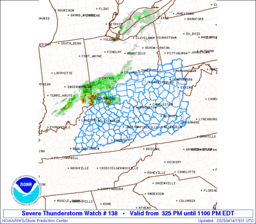
Tornado Watch Number 138
NWS Storm Prediction Center Norman OK
535 AM CDT Fri Apr 26 2024

The NWS Storm Prediction Center has issued a

* Tornado Watch for portions of
  Eastern Oklahoma

* Effective this Friday morning from 535 AM until 1100 AM CDT.

* Primary threats include...
  A few tornadoes possible
  Scattered damaging wind gusts to 70 mph possible
  Isolated large hail events to 1 inch in diameter possible

SUMMARY...A squall line with embedded bowing segments/mesovortices
will pose a continued threat for a couple of tornadoes, damaging
gusts of 60-70 mph and isolated large hail near 1 inch diameter
through mid morning.

The tornado watch area is approximately along and 45 statute miles
east and west of a line from 25 miles east northeast of Tulsa OK to
35 miles east southeast of Mcalester OK. For a complete depiction of
the watch see the associated watch outline update (WOUS64 KWNS
WOU8).

PRECAUTIONARY/PREPAREDNESS ACTIONS...

REMEMBER...A Tornado Watch means conditions are favorable for
tornadoes and severe thunderstorms in and close to the watch
area. Persons in these areas should be on the lookout for
threatening weather conditions and listen for later statements
and possible warnings.

&&

OTHER WATCH INFORMATION...CONTINUE...WW 137...

AVIATION...Tornadoes and a few severe thunderstorms with hail
surface and aloft to 1 inch. Extreme turbulence and surface wind
gusts to 60 knots. A few cumulonimbi with maximum tops to 500. Mean
storm motion vector 25040.

...Thompson
https://www.spc.noaa.gov/products/watch/ww0138.html
date: 2024-04-26, from: NOAA tornado/severe thunderstorm watches, mesoscale discussions, convective outlooks, fire weather outlooks

STATUS REPORT ON WW 138

SEVERE WEATHER THREAT CONTINUES RIGHT OF A LINE FROM 35 S MLC TO
20 SE MLC TO 25 ENE MLC TO 25 W RKR TO 20 NW RKR TO 30 WNW FSM TO
25 NNW FSM TO 30 SSW UMN.

..JEWELL..04/26/24

ATTN...WFO...TSA...


STATUS REPORT FOR WT 138

SEVERE WEATHER THREAT CONTINUES FOR THE FOLLOWING AREAS

OKC077-079-127-135-261440-

OK
.    OKLAHOMA COUNTIES INCLUDED ARE

LATIMER              LE FLORE            PUSHMATAHA
SEQUOYAH


THE WATCH STATUS MESSAGE IS FOR GUIDANCE PURPOSES ONLY.  PLEASE
REFER TO WATCH COUNTY NOTIFICATION STATEMENTS FOR OFFICIAL
INFORMATION ON COUNTIES...INDEPENDENT CITIES AND MARINE ZONES
CLEARED FROM SEVERE THUNDERSTORM AND TORNADO WATCHES.
https://www.spc.noaa.gov/products/watch/ws0138.html
date: 2024-04-26, from: NOAA tornado/severe thunderstorm watches, mesoscale discussions, convective outlooks, fire weather outlooks

Day 1 Convective Outlook
NWS Storm Prediction Center Norman OK
0753 AM CDT Fri Apr 26 2024

Valid 261300Z - 271200Z

...THERE IS AN ENHANCED RISK OF SEVERE THUNDERSTORMS THIS
AFTERNOON/EVENING ACROSS NORTHEAST KS/SOUTHEAST NE/NORTHWEST
MO/SOUTHWEST IA...

...SUMMARY...
A few tornadoes, including a couple of strong tornadoes, isolated
very large hail (greater than 2 inch diameter) and isolated wind
damage will be possible, mainly this afternoon/evening from
northeast Kansas/southeast Nebraska into northwest Missouri and
southwest Iowa.  Occasional severe storms are expected farther south
into Arkansas, eastern Oklahoma and northeast Texas.

...Mid MO Valley to TX through tonight...
A complex surface pattern is evident this morning with a cyclone in
northern KS, a trailing dryline/Pacific front into western OK, and
the east edge of the warm sector demarcated by a warm front from
eastern OK into eastern KS.  An ongoing QLCS with occasional wind
damage and tornado reports is moving across eastern OK near the warm
front, with an area of rain-cooled/overturned in OK in the wake of
these storms.  Farther north, an undisturbed portion of the warm
sector extends across central KS.

The eastern OK convection will likely persist through the day toward
western AR, with additional expansion of rain/thunderstorms farther
northeast into southwest/central MO.  The OK/AR portion of this
convection will be the most likely to maintain access to the surface
warm sector through the day, where a mix of bowing segments or
embedded supercells will be possible with all hazards.

The clouds/rain will slow the northeastward progress of the warm
sector, and northward advection of the overturned airmass in OK will
potentially impact the breadth and quality of the unstable warm
sector this afternoon.  Assuming sufficient recovery during the day,
there will be a window of opportunity for tornadic supercells along
the dryline this afternoon/evening starting in northeast
KS/southeast NE and spreading into northwest MO/southwest IA.
MLCAPE at or above 2000 J/kg, boundary-layer dewpoints in the mid
60s, and sufficiently long hodographs with low-level hodograph
curvature (effective bulk shear in excess of 50 kt, and effective
SRH of 200-300 m2/s2) suggest the potential for a couple of strong
tornadoes with any persistent, semi-discrete supercells.  Isolated
very large hail (in excess of 2 inches in diameter) will also be
possible, while the potential for a few damaging gusts will
accompany any upscale growth into line segments this evening.

Additional thunderstorm development will be possible today farther
southwest into TX, in association with weak height falls on the
southern fringe of the ejecting midlevel trough.  The 12z FWD
sounding showed only a weak cap, so the SLGT has been expanded some
to the southwest to account for large hail/wind damage potential
today.  Storms will likely weaken by this evening as weak height
rises commence and the remnant dryline begins to retreat to the
west.

..Thompson/Guyer.. 04/26/2024
https://www.spc.noaa.gov/products/outlook/day1otlk_1300.html
date: 2024-04-26, from: NOAA tornado/severe thunderstorm watches, mesoscale discussions, convective outlooks, fire weather outlooks
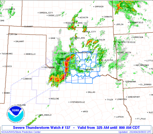
STATUS REPORT ON WW 137

SEVERE WEATHER THREAT CONTINUES RIGHT OF A LINE FROM 50 W GYI TO
10 WNW ADM TO 40 NNE ADM TO 15 N MLC.

..JEWELL..04/26/24

ATTN...WFO...OUN...FWD...


STATUS REPORT FOR WS 137

SEVERE WEATHER THREAT CONTINUES FOR THE FOLLOWING AREAS

OKC005-013-019-029-063-069-085-095-099-123-261440-

OK
.    OKLAHOMA COUNTIES INCLUDED ARE

ATOKA                BRYAN               CARTER
COAL                 HUGHES              JOHNSTON
LOVE                 MARSHALL            MURRAY
PONTOTOC


THE WATCH STATUS MESSAGE IS FOR GUIDANCE PURPOSES ONLY.  PLEASE
REFER TO WATCH COUNTY NOTIFICATION STATEMENTS FOR OFFICIAL
INFORMATION ON COUNTIES...INDEPENDENT CITIES AND MARINE ZONES
CLEARED FROM SEVERE THUNDERSTORM AND TORNADO WATCHES.
https://www.spc.noaa.gov/products/watch/ws0137.html
date: 2024-04-25, from: NOAA tornado/severe thunderstorm watches, mesoscale discussions, convective outlooks, fire weather outlooks
No watches are valid as of Thu Apr 25 12:36:01 UTC 2024.
https://www.spc.noaa.gov/products/watch/
date: 2024-04-25, from: NOAA tornado/severe thunderstorm watches, mesoscale discussions, convective outlooks, fire weather outlooks
No Mesoscale Discussions are in effect as of Thu Apr 25 12:36:01 UTC 2024.
https://www.spc.noaa.gov/products/md/
date: 2024-04-25, from: NOAA tornado/severe thunderstorm watches, mesoscale discussions, convective outlooks, fire weather outlooks
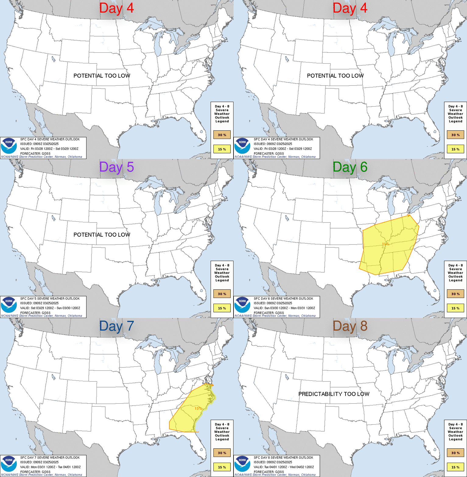
Day 4-8 Convective Outlook
NWS Storm Prediction Center Norman OK
0400 AM CDT Thu Apr 25 2024

Valid 281200Z - 031200Z

...DISCUSSION...
...D4/Sunday - Northeast TX into parts of the upper MS Valley...
Some severe threat is expected persist into D4/Sunday from northeast
TX into parts of the upper MS Valley, as an amplified
mid/upper-level shortwave trough moves from the Great Plains into
the upper Great Lakes region. Substantial convection on D3/Saturday
results in some uncertainty regarding storm evolution on Sunday.
However, guidance generally suggests that a strong mid/upper-level
jet associated with the ejecting shortwave will overspread a
relatively moist warm sector, with potential redevelopment of
organized convection along/ahead of a cold front.

There is some potential for the threat to be bimodal, with one
potential area from eastern KS into northern MO and IA in closer
proximity to the ejecting shortwave, and a separate area across the
ArkLaTex vicinity, within a region of somewhat more favorable
moisture and instability. However, with storm evolution remaining
rather uncertain, a continuous 15% area has been maintained in this
outlook, with some adjustments.

...D5/Monday - Southern Plains into the lower MS Valley...
Guidance generally suggests that a low-amplitude shortwave trough
will move across parts of TX into the lower MS Valley on Monday.
There is some potential for this shortwave to impinge upon a region
of moderate to strong buoyancy along and south of a weak surface
boundary that may begin to lift northward across parts of TX/LA
during the day. A few severe storms with a threat of hail and
damaging winds would be possible in this scenario. However,
uncertainty related to substantial antecedent convection and its
effect on boundary placement renders predictability too low for
probabilities at this time.

...D6/Tuesday - D8/Thursday...
Spread begins to notably increase in extended-range guidance
regarding pattern evolution by D6/Tuesday. In general, stronger
mid/upper-level flow is expected to shift northward, through there
will be some potential for shortwave troughs and related cold fronts
to impinge upon a reservoir of richer low-level moisture and
stronger buoyancy from the southern Plains into parts of the
Southeast/OH Valley. Confidence in the details regarding any severe
potential in this time frame is much too low for probabilities with
this outlook.
https://www.spc.noaa.gov/products/exper/day4-8/
date: 2024-04-24, from: NOAA Weather Forecasts
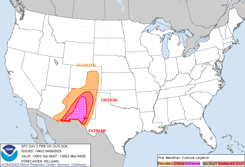
Day 2 Fire Weather Outlook
NWS Storm Prediction Center Norman OK
0200 AM CDT Wed Apr 24 2024

Valid 251200Z - 261200Z

...CRITICAL FIRE WEATHER AREA FOR PORTIONS OF THE SOUTHERN AND
CENTRAL HIGH PLAINS...

...Synopsis...
A midlevel trough will cross the Southwest during the day, while a
related 60-70 kt southwesterly midlevel jet overspreads the southern
into central High Plains. In response, a lee cyclone will rapidly
deepen over eastern CO/western KS, while a southward-extending
dryline sharpens over parts of west TX. This large-scale pattern
evolution will favor an expansive area of high-end critical
fire-weather conditions across the southern into central High Plains
during the afternoon.

...Southern into Central High Plains...
Behind the dryline, strong downslope warming/drying and diurnal
heating will result in a deep/dry boundary layer, characterized by
surface temperatures in the 80s and single-digit to lower-teens RH.
Here, a tightening surface pressure gradient peripheral to the
deepening lee cyclone, coupled with mixing into the strong
deep-layer southwesterly flow, will yield 30 mph sustained
southwesterly surface winds (with gusts upwards of 45 mph) across
eastern NM into southeastern CO. While confidence is high in the
development of these extremely critical meteorological conditions, a
potential lack of abundant and very dry fuels precludes Extremely
Critical highlights at this time.

..Weinman.. 04/24/2024

...Please see www.spc.noaa.gov/fire for graphic product...
https://www.spc.noaa.gov/products/fire_wx/fwdy2.html
date: 2024-04-24, from: Graphical Tropical Weather Outlooks
The Atlantic hurricane season runs from June 1st through November 30th.
https://www.nhc.noaa.gov/gtwo.php?basin=atlc
date: 2024-04-23, from: NOAA tornado/severe thunderstorm watches, mesoscale discussions, convective outlooks, fire weather outlooks

Day 1 Convective Outlook
NWS Storm Prediction Center Norman OK
1123 AM CDT Tue Apr 23 2024

Valid 231630Z - 241200Z

...THERE IS A SLIGHT RISK OF SEVERE THUNDERSTORMS FOR NORTHWEST
TEXAS...

...SUMMARY...
Isolated severe thunderstorms capable of producing large hail
(potentially 2+ inch diameter) and gusts to 65 mph will be possible
this afternoon and evening across northwest Texas.

...Northwest TX...
Visible satellite imagery and surface analysis this morning indicate
the initial stage of moisture return is occurring across the
southern Great Plains in the wake of a frontal intrusion into the
Gulf a few days ago.  A mid-level ridge will increasingly become
established across the central/southern Rockies and adjacent High
Plains as a Great Lakes disturbance gradually becomes more displaced
from the region.  An associated cold front will move southward
across KS/OK before eventually stalling tonight across southeast OK
and northwest TX.  Weak lee cyclogenesis will aid in maintaining a
southerly low-level fetch across central into west TX as strong
heating results in a sharpening dryline by late afternoon.  Isolated
thunderstorm development will be most probable near the triple point
20-22Z.  Steep lapse rates coupled with adequate moisture (1500-2000
J/kg MLCAPE) and veering flow beneath moderate westerlies, will
support an initial supercell mode.  Isolated very large hail of
2-2.5 inches in diameter will be the main threat, along with a few
55-65 mph gusts.

...Northern IL/southeast WI/Lower MI late this afternoon/evening...
Have not changed the existing outlook for this region due primarily
to consistency in model data and the forecast conceptual model not
deviating.  Water-vapor imagery this morning shows a mid-level
trough over the Upper Midwest and this will continue southeast into
the central Great Lakes by mid evening.  An associated surface
trough will likewise move southeastward, and this trough will be
preceded by a band of rain with minimal buoyancy.  Behind the rain
band, surface heating with steepening low-level lapse rates and
cooling midlevel temperatures will support weak surface-based
buoyancy just ahead of a secondary frontal surge.  Some low-topped
convection will be possible late this afternoon through late evening
from northern IL/southeast WI into Lower MI.  The stronger storms
could yield a localized marginal hail/damaging wind threat.

..Smith/Moore.. 04/23/2024
https://www.spc.noaa.gov/products/outlook/day1otlk_1630.html
date: 2024-04-23, from: NOAA tornado/severe thunderstorm watches, mesoscale discussions, convective outlooks, fire weather outlooks

Day 1 Fire Weather Outlook
NWS Storm Prediction Center Norman OK
1107 AM CDT Tue Apr 23 2024

Valid 231700Z - 241200Z

...NO CRITICAL AREAS...

The previous forecast (see below) remains on track, with no changes
or additions made.

..Squitieri.. 04/23/2024

.PREV DISCUSSION... /ISSUED 0128 AM CDT Tue Apr 23 2024/

...Synopsis...
A midlevel trough will advance east-southeastward from the Midwest
toward the Northeast through the period, while an upper ridge
encompasses much of the West. On the backside of the midlevel
trough, a post-frontal air mass will infiltrate the northern and
central Plains, where breezy/gusty northerly surface winds are
expected. Over portions of southern NE and KS, these winds could
briefly overlap 20-30 percent afternoon RH, favoring locally
elevated fire-weather conditions -- given receptive fuels across the
area. However, these conditions appear too brief and marginal for
Elevated highlights at this time.

Farther west, dry/breezy conditions are expected across the
Southwest during the afternoon. However, fuels are generally not
supportive of large fires at this time.

...Please see www.spc.noaa.gov/fire for graphic product...
https://www.spc.noaa.gov/products/fire_wx/fwdy1.html
date: 2024-04-22, from: NOAA tornado/severe thunderstorm watches, mesoscale discussions, convective outlooks, fire weather outlooks
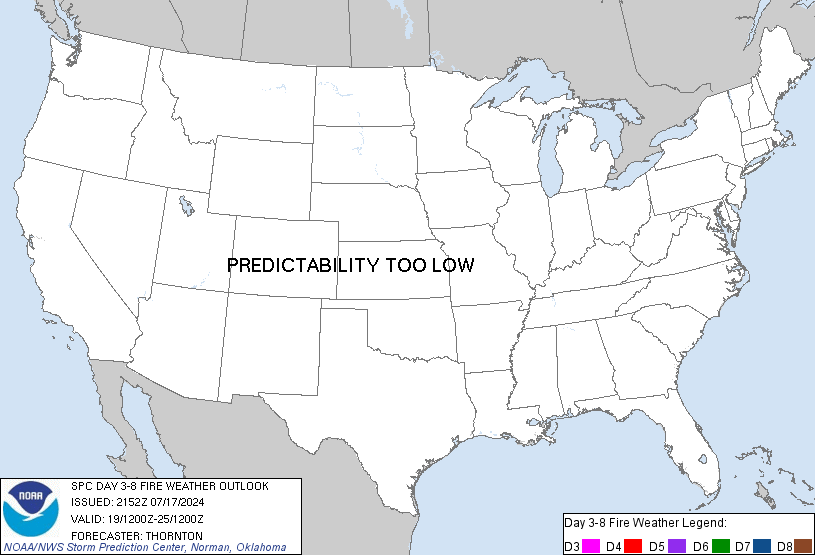
Day 3-8 Fire Weather Outlook
NWS Storm Prediction Center Norman OK
0344 PM CDT Mon Apr 22 2024

Valid 241200Z - 301200Z

A relatively active fire weather pattern is poised to set up across
the southern High Plains late this week through this weekend. By
Thursday, the first in a series of mid-level troughs will approach
the southern Rockies, with surface low development likely across the
central High Plains. By Thursday afternoon, a dryline will surge
eastward across the southern High Plains, with Critically dry and
windy conditions occurring behind the dryline. For Friday through
the weekend, the approach/passage of another mid-level trough and
associated surface cyclone will support continued eastward dryline
surges over the southern High Plains, accompanied by Critically dry
and windy conditions each afternoon. 70 percent Critical
probabilities have been issued Days 4-6 (Thursday-Saturday) where
Critical conditions should be most prolonged, and where fuels are
most receptive to wildfire spread. Dry conditions should persist
across the southern High Plains into early next week, though it is
currently unclear if the surface winds will approach Critical
thresholds.

..Squitieri.. 04/22/2024

...Please see www.spc.noaa.gov/fire for graphic product...
https://www.spc.noaa.gov/products/exper/fire_wx/
date: 2024-04-22, from: NOAA tornado/severe thunderstorm watches, mesoscale discussions, convective outlooks, fire weather outlooks

Day 1 Convective Outlook
NWS Storm Prediction Center Norman OK
0238 PM CDT Mon Apr 22 2024

Valid 222000Z - 231200Z

...THERE IS A MARGINAL RISK OF SEVERE THUNDERSTORMS OVER FAR
SOUTHEASTERN FLORIDA...

...SUMMARY...
Strong to locally severe thunderstorms, capable of marginally severe
wind gusts and hail, remain possible near the southeast Florida
coast this afternoon.

No changes were made to the ongoing outlook.

A low threat of severe storms remains this afternoon for the coastal
counties of far southeastern FL. Storms are ongoing near a weak
boundary, with 1500+ J/kg MUCAPE present. Locally strong gusts or
brief/marginal hail may occur over the next few hours, prior to
storms moving offshore.

..Jewell.. 04/22/2024

.PREV DISCUSSION... /ISSUED 1111 AM CDT Mon Apr 22 2024/

...South FL...
Visible satellite imagery shows a swelling cumulus field over the
Everglades and South FL ahead of a southward-progressing cold front
over the northern part of the Everglades.  A mid-level shortwave
trough located over the Carolinas/northeast Gulf of Mexico
--embedded within a larger-scale eastern North America trough-- will
continue east into the western Atlantic through the evening.
Continued warming of a moist airmass across south FL will yield
moderate destabilization.  Isolated thunderstorms are forecast to
develop in the vicinity of the front through the mid afternoon.
Long, straight hodographs combined with more than adequate CAPE will
potentially yield a couple of organized storms.  An isolated risk
for large hail and/or localized damaging gust will be the primary
hazards with the most intense storms.  This activity will push east
of the coast by early evening.

Elsewhere, quiescent conditions will prevail across a large part of
the contiguous United States.
https://www.spc.noaa.gov/products/outlook/day1otlk_2000.html