(date: 2024-05-03 22:49:20)
date: 2024-05-03, from: NOAA Weather Forecasts
Day 3-8 Fire Weather Outlook
NWS Storm Prediction Center Norman OK
0401 PM CDT Fri May 03 2024

Valid 051200Z - 111200Z

An active period of fire weather concerns remains likely beginning
late this weekend and lasting well into the upcoming work week. The
greatest fire weather risk will be focused across the central to
southern Rockies and into adjacent areas of the central/southern
High Plains where a dry air mass is already in place. Latest
ensemble guidance continues to show strong agreement in the
evolution of an upper-level trough (currently noted in water-vapor
imagery over the northeast Pacific) as it translates east across the
inter-mountain West and into the Plains Sunday and Monday, reaching
the Great Lakes/northern Plains by Tuesday/Wednesday. Strong low to
mid-level flow associated with this system will support multiple
days of dry, windy conditions with an accompanying fire weather
risk.

...D3/Sunday to D6/Wednesday - New Mexico and adjacent portions of
TX/CO...
Strong divergence aloft ahead of the approaching upper-level wave
will support broad surface pressure falls across the central Rockies
on Sunday afternoon. In response, southerly winds will increase
across much of the Four Corners region into central and eastern NM.
Latest mid-range ensemble guidance suggests sustained 20-25 mph
winds will be common by late afternoon when RH values should be
reaching their diurnal minimums between 10-20%. Although fuels
across western NM are not overly dry as of Friday afternoon,
dry/windy conditions on Saturday across this region should help cure
finer fuels by Sunday.

Perhaps the most intense fire weather conditions are anticipated on
Monday afternoon across portions of east/northeast NM. The ejection
of the surface low into the Plains Monday afternoon will support
strong westerly downslope winds off the central/southern Rockies.
This will maintain dry conditions across the region with 10-20% RH
common. Elevated conditions are expected across a broad swath of the
High Plains with critical conditions likely across much of eastern
NM. Latest forecast guidance hints that 25-30 mph sustained winds
are probable across northeast NM in the lee of the Sangre de Cristo
Mountains. While this portion of northeast NM is currently receiving
rainfall, such dry/windy conditions should yield dried grasses after
a few hours.

Persistent zonal flow will linger over the southern Rockies
D5/Tuesday into D6/Wednesday. This will maintain a downslope flow
regime with an attendant dry air mass (afternoon minimum RH values
in the teens) across the southern High Plains with potential both
days for elevated to critical fire weather conditions. The critical
risk areas have been adjusted in this outlook update to reflect
where medium to long-range ensemble guidance shows the strongest
signal for sustained 20+ mph winds. These areas will likely be
refined in subsequent outlooks as mesoscale details come into focus.
Elevated conditions may linger into D7/Thursday across southern NM,
but weakening gradient winds aloft should limit fire weather
potential compared to previous days.

..Moore.. 05/03/2024

...Please see www.spc.noaa.gov/fire for graphic product...
https://www.spc.noaa.gov/products/exper/fire_wx/
date: 2024-05-03, from: NOAA tornado/severe thunderstorm watches, mesoscale discussions, convective outlooks, fire weather outlooks
No watches are valid as of Fri May 3 14:47:02 UTC 2024.
https://www.spc.noaa.gov/products/watch/
date: 2024-05-03, from: NOAA tornado/severe thunderstorm watches, mesoscale discussions, convective outlooks, fire weather outlooks
No Mesoscale Discussions are in effect as of Fri May 3 14:47:02 UTC 2024.
https://www.spc.noaa.gov/products/md/
date: 2024-05-03, from: NOAA tornado/severe thunderstorm watches, mesoscale discussions, convective outlooks, fire weather outlooks

Day 1 Convective Outlook
NWS Storm Prediction Center Norman OK
0752 AM CDT Fri May 03 2024

Valid 031300Z - 041200Z

...THERE IS AN ENHANCED RISK OF SEVERE THUNDERSTORMS FROM NEAR THE
WEST TEXAS CAPROCK ONTO ADJOINING LOW ROLLING PLAINS...

...THERE IS A SLIGHT RISK OF SEVERE THUNDERSTORMS SURROUNDING THE
ENHANCED AREA...AND OVER PORTIONS OF THE CENTRAL PLAINS...

...SUMMARY...
Large hail and damaging gusts are possible over parts of the
central/southern Great Plains from southern Nebraska to west Texas,
along with some tornado potential over parts of west Texas.

...Synopsis...
Today's transitional mid/upper-level synoptic pattern is a tale of
two cyclones -- one astride the Upper Midwest/Canadian border, and
another digging southeastward out of the Gulf of Alaska.  The broad,
complex leading cyclone will eject northeastward over MB and
northwestern ON through the period.  A trailing shortwave trough --
apparent in moisture-channel imagery over parts of southern ID and
northern NV -- will move east-northeastward to eastern SD and
central NE by 12Z tomorrow.  The strong, well-developed Pacific
cyclone will proceed southeastward to just off the coast of OR by
the end of the period.  Southwest flow aloft will be maintained with
weak synoptic-scale height rises over most of the central/southern
Plains.  Still, sufficient moisture, buoyancy, lift and shear are
apparent for a couple relative maxima in severe potential as
discussed below.

At the surface, 11Z analysis showed a low attached to a cold front
over south-central WY.  The front should proceed southeastward
through the day, extending from southeastern SD to western NE an
central CO by 00Z, with the low over northeastern CO.  By 12Z
tomorrow, the front should extend from a low over IA to south-
central KS, the northern TX Panhandle, and north-central NM.  This
front will overtake a developing dryline over the central High
Plains from north-south, with the dryline position at 00Z over
eastern CO, the western TX Panhandle, and Permian Basin.  A weak/
residual, nearly stationary front extended from a low near FST
northeastward across northwest TX, eastern OK and the Ozarks, and
should continue to lose definition amidst considerable convective
outflow.  The southern rim of that outflow was evident from
southeast TX (between GLS-BPT) across the HOU metro then west-
northwestward to near SJT.  The western part will shift northward
slowly through the day toward the front, which itself should drift
northward up the Caprock.

...West/southwest TX...
Widely scattered to scattered thunderstorms are expected to form
this afternoon near the dryline and the residual outflow boundary
over the South Plains to Low Rolling Plains/Concho Valley regions.
Isolated to widely scattered convection possible farther south off
the dryline past the Rio Grande, and into strongly heated/CINH-
minimized higher terrain of the Serranias del Burro range in
northern Coahuila.  This activity should move eastward across areas
below the Caprock and around the Big Country to Edwards Plateau,
with potential for some of the Mexican convection to cross the Rio
Grande this evening as well.  Supercells -- with large to very large
hail and at least isolated potential for tornadoes -- will be more
probable in and near the 30%/"enhanced" hail area.  Dryline and
orographic activity to the south will be an early hail/wind threat.
Some of this activity may aggregate into clusters offering mainly
strong-severe gusts, with one or two small MCSs possible this
evening into the early overnight hours.

Despite multiple days of MCS and smaller-scale convective activity
to the east and southeast, a reservoir of rich low-level moisture
remains not far upstream across south-central TX and into the
southern Edwards Plateau, where upper 60s to low 70s F surface
dewpoints and PW commonly 1-1.5 inches.  When advected northwestward
amid diurnal heating and beneath steep midlevel lapse rates,
3000-4000 J/kg MLCAPE should become common.  Though low-level flow
should not be particularly strong, it will be backed, contributing
to elongated hodographs ad around 30-40 kt effective-shear
magnitudes.  Splitting storms may be common early, offering the
greatest hail potential (size and coverage).  The damaging-wind
threat will be maximized on the mesoscale where organized cold pools
can develop, and should extend farther east at greater density than
the hail potential this evening into tonight.  In the absence of
substantial large-scale support, tornado potential will be locally
maximized with any supercells that can interact favorably with
outflow boundaries or each other.

...Central Plains...
Large hail and severe gusts are possible from mid/late afternoon
into tonight, from thunderstorms shifting eastward across portions
of the central Plains.  Though nowhere nearly as moist as the TX
outlook area, a diurnally destabilized plume of moist advection
should support a secondary relative max in severe potential
along/ahead of the cold front and dryline from parts of eastern CO
to western/northern KS and southern NE.  Convection should develop
by mid/late afternoon in a regional convergence maximum near and
northeast of the surface low, with MLCINH weakened by favorable
diurnal heating.  Surface dewpoints in the 40s to low 50s F should
be common, with steep surface-500-mb lapse rates, 500-1000 J/kg
MLCAPE and well-mixed subcloud layers.  Effective-shear magnitudes
around 40-50 kt indicate potential for organized convection -- both
in quasi-linear form near the front and initially discrete (but
later merging upscale) off the dryline.  Though activity will
encounter a more-stable boundary layer with time and eastward extent
across KS/NE, at least marginal severe-gust potential may last
overnight as far eastward as parts of the Missouri Valley region.

..Edwards/Broyles.. 05/03/2024
https://www.spc.noaa.gov/products/outlook/day1otlk_1300.html
date: 2024-05-02, from: NOAA tornado/severe thunderstorm watches, mesoscale discussions, convective outlooks, fire weather outlooks

STATUS REPORT ON WW 170

THE SEVERE WEATHER THREAT CONTINUES ACROSS THE ENTIRE WATCH AREA.

..SQUITIERI..05/01/24

ATTN...WFO...MAF...SJT...


STATUS REPORT FOR WS 170

SEVERE WEATHER THREAT CONTINUES FOR THE FOLLOWING AREAS

TXC003-033-043-081-103-105-115-135-151-165-173-227-235-317-329-
335-353-371-383-413-415-431-435-443-451-461-020040-

TX
.    TEXAS COUNTIES INCLUDED ARE

ANDREWS              BORDEN              BREWSTER
COKE                 CRANE               CROCKETT
DAWSON               ECTOR               FISHER
GAINES               GLASSCOCK           HOWARD
IRION                MARTIN              MIDLAND
MITCHELL             NOLAN               PECOS
REAGAN               SCHLEICHER          SCURRY
STERLING             SUTTON              TERRELL
TOM GREEN            UPTON


THE WATCH STATUS MESSAGE IS FOR GUIDANCE PURPOSES ONLY.  PLEASE
REFER TO WATCH COUNTY NOTIFICATION STATEMENTS FOR OFFICIAL
INFORMATION ON COUNTIES...INDEPENDENT CITIES AND MARINE ZONES
CLEARED FROM SEVERE THUNDERSTORM AND TORNADO WATCHES.
https://www.spc.noaa.gov/products/watch/ws0170.html
date: 2024-05-02, from: NOAA tornado/severe thunderstorm watches, mesoscale discussions, convective outlooks, fire weather outlooks

URGENT - IMMEDIATE BROADCAST REQUESTED
Severe Thunderstorm Watch Number 170
NWS Storm Prediction Center Norman OK
125 PM CDT Wed May 1 2024

The NWS Storm Prediction Center has issued a

* Severe Thunderstorm Watch for portions of
  West Texas

* Effective this Wednesday afternoon and evening from 125 PM
  until 900 PM CDT.

* Primary threats include...
  Scattered large hail and isolated very large hail events to 3
    inches in diameter likely
  Scattered damaging winds likely with isolated significant gusts
    to 80 mph possible
  A tornado or two possible

SUMMARY...Thunderstorms will intensify this afternoon along the
dryline, tracking eastward through the early evening.  Very large
hail and damaging winds are possible, along with an isolated tornado
or two.

The severe thunderstorm watch area is approximately along and 60
statute miles east and west of a line from 55 miles north northeast
of Big Spring TX to 40 miles southwest of Dryden TX. For a complete
depiction of the watch see the associated watch outline update
(WOUS64 KWNS WOU0).

PRECAUTIONARY/PREPAREDNESS ACTIONS...

REMEMBER...A Severe Thunderstorm Watch means conditions are
favorable for severe thunderstorms in and close to the watch area.
Persons in these areas should be on the lookout for threatening
weather conditions and listen for later statements and possible
warnings. Severe thunderstorms can and occasionally do produce
tornadoes.

&&

AVIATION...A few severe thunderstorms with hail surface and aloft to
3 inches. Extreme turbulence and surface wind gusts to 70 knots. A
few cumulonimbi with maximum tops to 500. Mean storm motion vector
25030.

...Hart
https://www.spc.noaa.gov/products/watch/ww0170.html
date: 2024-05-02, from: NOAA tornado/severe thunderstorm watches, mesoscale discussions, convective outlooks, fire weather outlooks
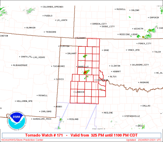
STATUS REPORT ON WW 171

THE SEVERE WEATHER THREAT CONTINUES ACROSS THE ENTIRE WATCH AREA.

FOR ADDITIONAL INFORMATION SEE MESOSCALE DISCUSSION 0592

..SQUITIERI..05/01/24

ATTN...WFO...AMA...OUN...LUB...


STATUS REPORT FOR WT 171

SEVERE WEATHER THREAT CONTINUES FOR THE FOLLOWING AREAS

OKC007-057-020040-

OK
.    OKLAHOMA COUNTIES INCLUDED ARE

BEAVER               HARMON


TXC011-045-065-075-087-101-107-125-129-153-155-169-179-189-191-
195-197-211-233-263-269-275-295-303-305-345-357-393-433-437-483-
020040-

TX
.    TEXAS COUNTIES INCLUDED ARE

ARMSTRONG            BRISCOE             CARSON
CHILDRESS            COLLINGSWORTH       COTTLE
CROSBY               DICKENS             DONLEY
FLOYD                FOARD               GARZA
GRAY                 HALE                HALL
HANSFORD             HARDEMAN            HEMPHILL
HUTCHINSON           KENT                KING
KNOX                 LIPSCOMB            LUBBOCK
LYNN                 MOTLEY              OCHILTREE
https://www.spc.noaa.gov/products/watch/ws0171.html
date: 2024-05-02, from: NOAA tornado/severe thunderstorm watches, mesoscale discussions, convective outlooks, fire weather outlooks

URGENT - IMMEDIATE BROADCAST REQUESTED
Tornado Watch Number 171
NWS Storm Prediction Center Norman OK
325 PM CDT Wed May 1 2024

The NWS Storm Prediction Center has issued a

* Tornado Watch for portions of
  Southwest Oklahoma
  Eastern Texas Panhandle

* Effective this Wednesday afternoon and evening from 325 PM
  until 1100 PM CDT.

* Primary threats include...
  A few tornadoes possible
  Widespread large hail and isolated very large hail events to 4
    inches in diameter likely
  Scattered damaging winds and isolated significant gusts to 75
    mph likely

SUMMARY...Widely scattered but intense thunderstorms are expected to
affect the watch area through the afternoon and evening.  Very large
hail, damaging wind gusts, and a few tornadoes will be possible with
these storms.

The tornado watch area is approximately along and 45 statute miles
east and west of a line from 5 miles west northwest of Liberal KS to
105 miles south southwest of Childress TX. For a complete depiction
of the watch see the associated watch outline update (WOUS64 KWNS
WOU1).

PRECAUTIONARY/PREPAREDNESS ACTIONS...

REMEMBER...A Tornado Watch means conditions are favorable for
tornadoes and severe thunderstorms in and close to the watch
area. Persons in these areas should be on the lookout for
threatening weather conditions and listen for later statements
and possible warnings.

&&

OTHER WATCH INFORMATION...CONTINUE...WW 170...

AVIATION...Tornadoes and a few severe thunderstorms with hail
surface and aloft to 4 inches. Extreme turbulence and surface wind
gusts to 65 knots. A few cumulonimbi with maximum tops to 500. Mean
storm motion vector 24035.

...Hart
https://www.spc.noaa.gov/products/watch/ww0171.html
date: 2024-05-02, from: NOAA tornado/severe thunderstorm watches, mesoscale discussions, convective outlooks, fire weather outlooks
STATUS FOR WATCH 0172 HAS NOT BEEN ISSUED YET
https://www.spc.noaa.gov/products/watch/ws0172.html
date: 2024-05-02, from: NOAA tornado/severe thunderstorm watches, mesoscale discussions, convective outlooks, fire weather outlooks
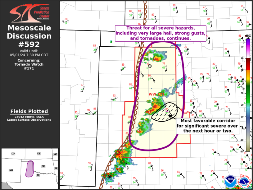
Mesoscale Discussion 0592
NWS Storm Prediction Center Norman OK
0607 PM CDT Wed May 01 2024

Areas affected...Eastern TX Panhandle...Far Northwestern TX...Far
Southwestern/Western OK

Concerning...Tornado Watch 171...

Valid 012307Z - 020030Z

The severe weather threat for Tornado Watch 171 continues.

SUMMARY...Threat for all severe hazards, including very large hail
from 2.5" to 3.5" in diameter, strong gusts up to 75 mph, and
tornadoes continues across the eastern TX Panhandle.

DISCUSSION...Several supercells are currently ongoing across the
eastern TX Panhandle, including a pair of tornadic storms, one over
Roberts Ochiltree Counties in the northeast TX Panhandle and the
other farther south in Briscoe and Hail Counties. Both of these
storms, as well as the other supercells developing southwestward
from the Panhandle into the Texas South Plains, are in a favorable
environment for persistence. Main factor influencing overall updraft
maintenance and storm persistence will be storm
mergers/interactions. Some secondary influence from anvil shading
and resulting boundary-layer cooling is possible, although this
could be offset by continuing low-level moisture advection. The
general expectation is for storms to persist, with perhaps one
substantial storm eventually emerging out of the cluster over
Briscoe and Hall Counties. Given the unimpeded inflow and
anticipated strengthening of low-level flow, this storm would likely
represent the best candidate for a significant severe weather,
including very large hail, strong gusts, and tornadoes, over the
next hour or two.

Storm motion has been relatively slow thus far, generally 15 to 20
kt, with a few storm moving even slower. As such, this activity will
likely remain in the eastern TX Panhandle (i.e. within Tornado Watch
171) for the next few hours. Even so, trends will be monitored for
faster storm motion and the potential for activity to move into
western OK earlier.

..Mosier.. 05/01/2024

...Please see www.spc.noaa.gov for graphic product...

ATTN...WFO...OUN...LUB...AMA...

LAT...LON   36030139 36650085 36369982 34399974 33330031 33380173
            35130151 36030139
https://www.spc.noaa.gov/products/md/md0592.html
date: 2024-05-02, from: NOAA tornado/severe thunderstorm watches, mesoscale discussions, convective outlooks, fire weather outlooks

URGENT - IMMEDIATE BROADCAST REQUESTED
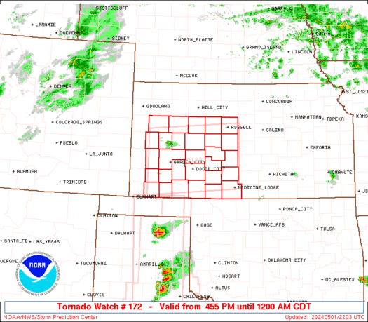
Tornado Watch Number 172
NWS Storm Prediction Center Norman OK
455 PM CDT Wed May 1 2024

The NWS Storm Prediction Center has issued a

* Tornado Watch for portions of
  Western and central Kansas

* Effective this Wednesday afternoon from 455 PM until Midnight
  CDT.

* Primary threats include...
  A couple tornadoes possible
  Scattered large hail likely with isolated very large hail events
    to 3.5 inches in diameter possible
  Scattered damaging wind gusts to 70 mph possible

SUMMARY...At least isolated severe storms including supercells are
expected to develop through early evening, initially near a surface
low and dryline and warm/nearly stationary front across western
Kansas. Even if storms remain relatively isolated, they will be
capable of very large hail, tornadoes, and very strong wind gusts.

The tornado watch area is approximately along and 60 statute miles
north and south of a line from 40 miles west of Garden City KS to 55
miles south southeast of Russell KS. For a complete depiction of the
watch see the associated watch outline update (WOUS64 KWNS WOU2).

PRECAUTIONARY/PREPAREDNESS ACTIONS...

REMEMBER...A Tornado Watch means conditions are favorable for
tornadoes and severe thunderstorms in and close to the watch
area. Persons in these areas should be on the lookout for
threatening weather conditions and listen for later statements
and possible warnings.

&&

OTHER WATCH INFORMATION...CONTINUE...WW 170...WW 171...

AVIATION...Tornadoes and a few severe thunderstorms with hail
surface and aloft to 3.5 inches. Extreme turbulence and surface wind
gusts to 60 knots. A few cumulonimbi with maximum tops to 500. Mean
storm motion vector 24025.

...Guyer
https://www.spc.noaa.gov/products/watch/ww0172.html
date: 2024-05-02, from: NOAA tornado/severe thunderstorm watches, mesoscale discussions, convective outlooks, fire weather outlooks
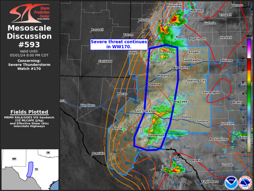
Mesoscale Discussion 0593
NWS Storm Prediction Center Norman OK
0658 PM CDT Wed May 01 2024

Areas affected...southwestern Texas

Concerning...Severe Thunderstorm Watch 170...

Valid 012358Z - 020100Z

The severe weather threat for Severe Thunderstorm Watch 170
continues.

SUMMARY...Severe threat continues within WW170. Instances of severe
hail and damaging wind will continue over the next couple of hours.

DISCUSSION...Thunderstorm activity continues in the northern and
southern portions of WW170. To the north, clustered cell activity
with transient supercell structures will continue to support risk of
instances of large hail and damaging wind. Recent reports of hail as
large as 1.5 in and gusts 50+ mph have been noted in this region.

Further south, storms have made attempts to grow upscale along
outflow, which will likely support a shift to increase in threat for
damaging wind (possibly as high as 70 mph) threat in the short term,
though instances of large hail will be possible.

Activity is largely supported dryline forcing and will likely wane
in coverage after sunset with the end of daytime heating. The
propensity for anvil spread downwind has also likely limited the
threat of further development with eastern extent, as witnessed by
meager development along a northward moving outflow boundary near
Upton and Reagan Counties.

..Thornton/Guyer.. 05/01/2024

...Please see www.spc.noaa.gov for graphic product...

ATTN...WFO...EWX...SJT...LUB...MAF...

LAT...LON   30130285 30890251 32380238 32890232 33020170 32930130
            31940128 31340140 30550159 30080179 29820190 29750208
            29750239 29880286 30130285
https://www.spc.noaa.gov/products/md/md0593.html
date: 2024-05-01, from: NOAA tornado/severe thunderstorm watches, mesoscale discussions, convective outlooks, fire weather outlooks

Day 1 Convective Outlook
NWS Storm Prediction Center Norman OK
0314 PM CDT Wed May 01 2024

Valid 012000Z - 021200Z

...THERE IS AN ENHANCED RISK OF SEVERE THUNDERSTORMS THIS AFTERNOON
AND EVENING FROM SOUTH-CENTRAL KANSAS INTO WESTERN OKLAHOMA/WEST
TEXAS...

...SUMMARY...
The greatest threat today for large to very large hail, severe
thunderstorm gusts and a few tornadoes will be in from south-central
Kansas into western Oklahoma, the eastern Texas Panhandle and
northwest/west-central Texas.

...20Z Update...
Severe probabilities have been expanded westward somewhat to account
for a farther west position of the dryline this afternoon.
Significant wind probabilities have also been added across parts of
west/northwest TX, where a mix of supercell clusters and eventual
MCS development will be possible.

The influence of extensive antecedent convection remains quite
evident across parts of KS/OK, with the richest moisture currently
confined from far western OK into the eastern TX Panhandle and
northwest TX, and pockets of somewhat higher dewpoints from
southeast KS into northeast OK, and also across southwestern KS,
where somewhat stronger recovery is occurring this afternoon.

Confidence remains rather low regarding storm coverage and evolution
along the dryline, though at least isolated supercell development
will be possible late this afternoon into the evening, with a threat
of all severe hazards.

Upscale growth into one or more clusters still appears likely across
central and possibly north TX tonight, with some potential for an
organized MCS to move into southeast TX before the end of the
period. An elevated storm cluster and possible MCS is also expected
to develop near the KS/NE border later tonight. While this
convection will likely remain mostly elevated, rather strong MUCAPE
will support at least an isolated threat for both hail and severe
gusts. See the previous discussion below for more information, and
MCD 589 for more information regarding the short-term threat from
southwest KS into the TX Panhandle. .

..Dean.. 05/01/2024

.PREV DISCUSSION... /ISSUED 1125 AM CDT Wed May 01 2024/

...Southern KS/Western OK/TX Panhandle...
Late morning surface analysis shows a low near Guymon OK, with a
remnant outflow boundary from overnight storms extending southward
through the eastern TX Panhandle and across southern OK.  It is
unclear whether this boundary will wash out through the afternoon,
or be maintained by shower/thunderstorm activity over southwest OK.
Regardless, thunderstorms will form rapidly on the dryline from
southwest KS into the eastern TX Panhandle late this afternoon and
interact with the remnant boundary.  Supercells capable of very
large hail, damaging winds, and tornadoes are possible along this
corridor through the early evening.  There is a chance of a strong
tornado or two, but confidence in position is not high enough to
increase tornado probabilities at this time.

...West TX...
Strong heating will occur today west of the dryline over west TX,
leading to scattered intense storm development.  Initial discrete
supercells will pose a risk of very large hail and a few tornadoes,
but organized outflows appear likely given latest model guidance,
which will promote damaging wind gusts as storms spread eastward
through the evening.

...Central TX today and tonight...
A very moist low-level air mass is in place today over south-central
TX, with dewpoints well into the 70s.  Scattered afternoon
thunderstorms are expected to form in this environment, where
sufficient CAPE and deep-layer shear will promote
organized/supercell structures.  Given the abundant low-level
theta-e and veering low-level wind fields, a tornado or two is
possible, along with locally gusty/damaging winds.

Tonight, storms that form over west TX may organize into an MCS and
track into central TX.  A strengthening sub-tropical mid-level wind
max will help to sustain the activity, with a continued risk of
damaging winds overnight.

...Southern NE/Northern KS tonight...
Relatively widespread thunderstorms are expected to form after dark
over southwest NE/northwest KS ahead of an approaching shortwave
trough.  This activity will spread eastward overnight, with
sufficient (mainly) elevated CAPE to support hail and gusty winds in
the stronger cores.
https://www.spc.noaa.gov/products/outlook/day1otlk_2000.html
date: 2024-05-01, from: NOAA tornado/severe thunderstorm watches, mesoscale discussions, convective outlooks, fire weather outlooks

Mesoscale Discussion 0584
NWS Storm Prediction Center Norman OK
0844 PM CDT Tue Apr 30 2024

Areas affected...Northern/Western Missouri

Concerning...Severe Thunderstorm Watch 166...

Valid 010144Z - 010315Z

The severe weather threat for Severe Thunderstorm Watch 166
continues.

SUMMARY...A few strong/severe storms will linger, mainly across
northern Missouri this evening.

DISCUSSION...Convective trends are down early this evening, partly
due to cooling boundary-layer conditions. Convection that developed
along/ahead of the cold front/dryline has advanced east-southeast
across the instability axis. This activity is encountering a less
buoyant environment and updrafts are gradually weakening. Latest
trends suggest convection near the IA border may linger a bit
longer, primarily due to the southern influence of the upper MS
Valley short-wave trough. Even so, marginally severe hail may become
the primary risk over the next hour or so.

..Darrow.. 05/01/2024

...Please see www.spc.noaa.gov for graphic product...

ATTN...WFO...LSX...DVN...SGF...EAX...TOP...

LAT...LON   38129544 40539430 40549200 38109323 38129544
https://www.spc.noaa.gov/products/md/md0584.html
date: 2024-05-01, from: NOAA tornado/severe thunderstorm watches, mesoscale discussions, convective outlooks, fire weather outlooks

Mesoscale Discussion 0583
NWS Storm Prediction Center Norman OK
0755 PM CDT Tue Apr 30 2024

Areas affected...Southeast IA...Northwest IL

Concerning...Tornado Watch 163...

Valid 010055Z - 010230Z

The severe weather threat for Tornado Watch 163 continues.

SUMMARY...Convection should gradually weaken as it spreads toward
the Mississippi River Valley. New watch is not anticipated
downstream.

DISCUSSION...A few supercells linger across southern IA, along the
southern fringe of large-scale support, in association with ejecting
short-wave trough. Most notable, longer-lived supercell is
propagating east across Appanoose County is approaching an air mass
that is increasingly hostile to surface-based updrafts. While
low-level lapse rates were steep at 00z/DVN, MLCAPE was only 40
J/kg, and nocturnal cooling will limit further destabilization.
While this lead storm may produce marginally severe hail, or perhaps
a brief tornado over the next hour or so, current thinking is
convection should gradually weaken as the evening progresses.

..Darrow.. 05/01/2024

...Please see www.spc.noaa.gov for graphic product...

ATTN...WFO...DVN...DMX...

LAT...LON   41489297 41519118 40519098 40659329 41489297
https://www.spc.noaa.gov/products/md/md0583.html
date: 2024-05-01, from: NOAA tornado/severe thunderstorm watches, mesoscale discussions, convective outlooks, fire weather outlooks

STATUS FOR WATCH 0167 HAS NOT BEEN ISSUED YET
https://www.spc.noaa.gov/products/watch/ws0167.html
date: 2024-05-01, from: NOAA tornado/severe thunderstorm watches, mesoscale discussions, convective outlooks, fire weather outlooks

URGENT - IMMEDIATE BROADCAST REQUESTED
Severe Thunderstorm Watch Number 167
NWS Storm Prediction Center Norman OK
845 PM CDT Tue Apr 30 2024

The NWS Storm Prediction Center has issued a

* Severe Thunderstorm Watch for portions of
  Northeast Oklahoma

* Effective this Tuesday night from 845 PM until Midnight CDT.

* Primary threats include...
  Scattered damaging winds and isolated significant gusts to 75
    mph possible
  Isolated large hail events to 1.5 inches in diameter possible

SUMMARY...A band of severe thunderstorms will likely progress
east-southeast across portions of northern and northeast Oklahoma
through the late evening.  Severe gusts and associated wind damage
will be the primary severe hazards accompanying this thunderstorm
complex.

The severe thunderstorm watch area is approximately along and 35
statute miles north and south of a line from 50 miles west southwest
of Bartlesville OK to 35 miles east northeast of Tulsa OK. For a
complete depiction of the watch see the associated watch outline
update (WOUS64 KWNS WOU7).

PRECAUTIONARY/PREPAREDNESS ACTIONS...

REMEMBER...A Severe Thunderstorm Watch means conditions are
favorable for severe thunderstorms in and close to the watch area.
Persons in these areas should be on the lookout for threatening
weather conditions and listen for later statements and possible
warnings. Severe thunderstorms can and occasionally do produce
tornadoes.

&&

OTHER WATCH INFORMATION...CONTINUE...WW 163...WW 164...WW
165...WW 166...

AVIATION...A few severe thunderstorms with hail surface and aloft to
1.5 inches. Extreme turbulence and surface wind gusts to 65 knots. A
few cumulonimbi with maximum tops to 450. Mean storm motion vector
29030.

...Smith
https://www.spc.noaa.gov/products/watch/ww0167.html
date: 2024-05-01, from: NOAA tornado/severe thunderstorm watches, mesoscale discussions, convective outlooks, fire weather outlooks
URGENT - IMMEDIATE BROADCAST REQUESTED
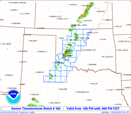
Severe Thunderstorm Watch Number 165
NWS Storm Prediction Center Norman OK
435 PM CDT Tue Apr 30 2024

The NWS Storm Prediction Center has issued a

* Severe Thunderstorm Watch for portions of
  Northern and Western Oklahoma
  Northwest Texas

* Effective this Tuesday afternoon and evening from 435 PM until
  900 PM CDT.

* Primary threats include...
  Scattered large hail and isolated very large hail events to 2.5
    inches in diameter possible
  Scattered damaging wind gusts to 70 mph possible
  A tornado or two possible

SUMMARY...Widely scattered to scattered thunderstorms will likely
develop through the late afternoon into the early evening near and
east of the dryline.  Some of the stronger storms will probably
become supercellular and pose a risk for large to very large hail
and severe gusts.  A narrow window of time may exist for a brief
tornado towards the early evening mainly over the Oklahoma portion
of the Watch.

The severe thunderstorm watch area is approximately along and 50
statute miles east and west of a line from 25 miles northwest of
Ponca City OK to 130 miles south southwest of Altus OK. For a
complete depiction of the watch see the associated watch outline
update (WOUS64 KWNS WOU5).

PRECAUTIONARY/PREPAREDNESS ACTIONS...

REMEMBER...A Severe Thunderstorm Watch means conditions are
favorable for severe thunderstorms in and close to the watch area.
Persons in these areas should be on the lookout for threatening
weather conditions and listen for later statements and possible
warnings. Severe thunderstorms can and occasionally do produce
tornadoes.

&&

OTHER WATCH INFORMATION...CONTINUE...WW 163...WW 164...

AVIATION...A few severe thunderstorms with hail surface and aloft to
2.5 inches. Extreme turbulence and surface wind gusts to 60 knots. A
few cumulonimbi with maximum tops to 500. Mean storm motion vector
24020.

...Smith
https://www.spc.noaa.gov/products/watch/ww0165.html
date: 2024-05-01, from: NOAA tornado/severe thunderstorm watches, mesoscale discussions, convective outlooks, fire weather outlooks

STATUS REPORT ON WW 165

THE SEVERE WEATHER THREAT CONTINUES ACROSS THE ENTIRE WATCH AREA.

FOR ADDITIONAL INFORMATION SEE MESOSCALE DISCUSSION 0581

..THORNTON..05/01/24

ATTN...WFO...OUN...SJT...LUB...


STATUS REPORT FOR WS 165

SEVERE WEATHER THREAT CONTINUES FOR THE FOLLOWING AREAS

OKC003-011-015-017-031-039-043-047-053-055-065-071-073-075-083-
093-103-141-149-151-010240-

OK
.    OKLAHOMA COUNTIES INCLUDED ARE

ALFALFA              BLAINE              CADDO
CANADIAN             COMANCHE            CUSTER
DEWEY                GARFIELD            GRANT
GREER                JACKSON             KAY
KINGFISHER           KIOWA               LOGAN
MAJOR                NOBLE               TILLMAN
WASHITA              WOODS


TXC023-155-197-207-263-269-275-433-447-485-487-010240-

TX
.    TEXAS COUNTIES INCLUDED ARE

BAYLOR               FOARD               HARDEMAN
HASKELL              KENT                KING
KNOX                 STONEWALL           THROCKMORTON
WICHITA              WILBARGER
https://www.spc.noaa.gov/products/watch/ws0165.html
date: 2024-05-01, from: NOAA tornado/severe thunderstorm watches, mesoscale discussions, convective outlooks, fire weather outlooks
URGENT - IMMEDIATE BROADCAST REQUESTED
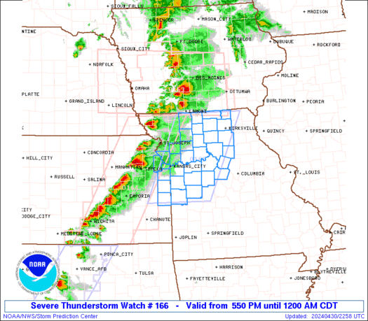
Severe Thunderstorm Watch Number 166
NWS Storm Prediction Center Norman OK
550 PM CDT Tue Apr 30 2024

The NWS Storm Prediction Center has issued a

* Severe Thunderstorm Watch for portions of
  Eastern Kansas
  Western and Northern Missouri

* Effective this Tuesday afternoon from 550 PM until Midnight
  CDT.

* Primary threats include...
  Scattered damaging winds and isolated significant gusts to 75
    mph likely
  Scattered large hail and isolated very large hail events to 2.5
    inches in diameter likely
  A tornado or two possible

SUMMARY...An organized band of severe thunderstorms over eastern
Kansas and northwest Missouri will continue to move east this
evening into the Watch area.  Supercells with an attendant risk for
large to very large hail, perhaps a tornado, and severe gusts are
possible before some upscale growth into one or more linear bands of
storms later this evening.  As the linear upscale growth occurs,
wind damage will increasingly become the primary severe hazard.

The severe thunderstorm watch area is approximately along and 60
statute miles east and west of a line from 45 miles northwest of
Kirksville MO to 55 miles south southeast of Olathe KS. For a
complete depiction of the watch see the associated watch outline
update (WOUS64 KWNS WOU6).

PRECAUTIONARY/PREPAREDNESS ACTIONS...

REMEMBER...A Severe Thunderstorm Watch means conditions are
favorable for severe thunderstorms in and close to the watch area.
Persons in these areas should be on the lookout for threatening
weather conditions and listen for later statements and possible
warnings. Severe thunderstorms can and occasionally do produce
tornadoes.

&&

OTHER WATCH INFORMATION...CONTINUE...WW 163...WW 164...WW 165...

AVIATION...A few severe thunderstorms with hail surface and aloft to
2.5 inches. Extreme turbulence and surface wind gusts to 65 knots. A
few cumulonimbi with maximum tops to 500. Mean storm motion vector
27035.

...Smith
https://www.spc.noaa.gov/products/watch/ww0166.html
date: 2024-05-01, from: NOAA tornado/severe thunderstorm watches, mesoscale discussions, convective outlooks, fire weather outlooks

STATUS REPORT ON WW 166

THE SEVERE WEATHER THREAT CONTINUES ACROSS THE ENTIRE WATCH AREA.

..SPC..05/01/24

ATTN...WFO...EAX...


STATUS REPORT FOR WS 166

SEVERE WEATHER THREAT CONTINUES FOR THE FOLLOWING AREAS

KSC091-103-107-121-209-010140-

KS
.    KANSAS COUNTIES INCLUDED ARE

JOHNSON              LEAVENWORTH         LINN
MIAMI                WYANDOTTE


MOC001-013-025-033-037-041-047-049-053-061-079-081-083-089-095-
101-107-115-117-121-129-159-165-171-175-177-195-197-211-
010140-

MO
.    MISSOURI COUNTIES INCLUDED ARE

ADAIR                BATES               CALDWELL
CARROLL              CASS                CHARITON
CLAY                 CLINTON             COOPER
DAVIESS              GRUNDY              HARRISON
HENRY                HOWARD              JACKSON
JOHNSON              LAFAYETTE           LINN
LIVINGSTON           MACON               MERCER
PETTIS               PLATTE              PUTNAM
RANDOLPH             RAY                 SALINE
SCHUYLER             SULLIVAN
https://www.spc.noaa.gov/products/watch/ws0166.html
date: 2024-05-01, from: NOAA tornado/severe thunderstorm watches, mesoscale discussions, convective outlooks, fire weather outlooks

STATUS REPORT ON WW 163

SEVERE WEATHER THREAT CONTINUES RIGHT OF A LINE FROM 35 W LWD TO
50 ESE FOD.

..SPC..05/01/24

ATTN...WFO...DMX...OAX...FSD...


STATUS REPORT FOR WT 163

SEVERE WEATHER THREAT CONTINUES FOR THE FOLLOWING AREAS

IAC007-039-051-053-083-099-117-121-123-125-127-135-153-157-159-
169-171-179-181-185-010140-

IA
.    IOWA COUNTIES INCLUDED ARE

APPANOOSE            CLARKE              DAVIS
DECATUR              HARDIN              JASPER
LUCAS                MADISON             MAHASKA
MARION               MARSHALL            MONROE
POLK                 POWESHIEK           RINGGOLD
STORY                TAMA                WAPELLO
WARREN               WAYNE


THE WATCH STATUS MESSAGE IS FOR GUIDANCE PURPOSES ONLY.  PLEASE
REFER TO WATCH COUNTY NOTIFICATION STATEMENTS FOR OFFICIAL
INFORMATION ON COUNTIES...INDEPENDENT CITIES AND MARINE ZONES
CLEARED FROM SEVERE THUNDERSTORM AND TORNADO WATCHES.
https://www.spc.noaa.gov/products/watch/ws0163.html
date: 2024-05-01, from: NOAA tornado/severe thunderstorm watches, mesoscale discussions, convective outlooks, fire weather outlooks

URGENT - IMMEDIATE BROADCAST REQUESTED
Tornado Watch Number 163
NWS Storm Prediction Center Norman OK
135 PM CDT Tue Apr 30 2024

The NWS Storm Prediction Center has issued a

* Tornado Watch for portions of
  Southern and Western Iowa
  Eastern Nebraska

* Effective this Tuesday afternoon and evening from 135 PM until
  1000 PM CDT.

* Primary threats include...
  A few tornadoes possible
  Scattered damaging winds and isolated significant gusts to 80
    mph likely
  Scattered large hail and isolated very large hail events to 2.5
    inches in diameter likely

SUMMARY...Severe thunderstorms will develop this afternoon over
eastern Nebraska and track eastward across the watch area through
the evening.

The tornado watch area is approximately along and 60 statute miles
north and south of a line from 50 miles north northwest of Lincoln
NE to 35 miles east of Knoxville IA. For a complete depiction of the
watch see the associated watch outline update (WOUS64 KWNS WOU3).

PRECAUTIONARY/PREPAREDNESS ACTIONS...

REMEMBER...A Tornado Watch means conditions are favorable for
tornadoes and severe thunderstorms in and close to the watch
area. Persons in these areas should be on the lookout for
threatening weather conditions and listen for later statements
and possible warnings.

&&

AVIATION...Tornadoes and a few severe thunderstorms with hail
surface and aloft to 2.5 inches. Extreme turbulence and surface wind
gusts to 70 knots. A few cumulonimbi with maximum tops to 500. Mean
storm motion vector 27035.

...Hart
https://www.spc.noaa.gov/products/watch/ww0163.html
date: 2024-05-01, from: NOAA tornado/severe thunderstorm watches, mesoscale discussions, convective outlooks, fire weather outlooks
URGENT - IMMEDIATE BROADCAST REQUESTED
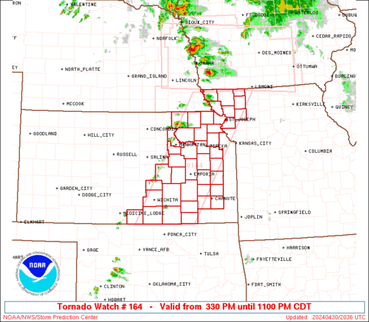
Tornado Watch Number 164
NWS Storm Prediction Center Norman OK
330 PM CDT Tue Apr 30 2024

The NWS Storm Prediction Center has issued a

* Tornado Watch for portions of
  Eastern Kansas
  Northwest Missouri

* Effective this Tuesday afternoon and evening from 330 PM until
  1100 PM CDT.

* Primary threats include...
  A few tornadoes possible
  Scattered large hail and isolated very large hail events to 2.5
    inches in diameter likely
  Scattered damaging wind gusts to 70 mph likely

SUMMARY...Thunderstorms will develop this afternoon along a cold
front/dryline over eastern Kansas and drift eastward through the
afternoon and evening.  Supercells capable of very large hail are
the main concern, although damaging winds and a tornado or two may
also occur.

The tornado watch area is approximately along and 55 statute miles
east and west of a line from 45 miles northeast of Falls City NE to
50 miles south southeast of Wichita KS. For a complete depiction of
the watch see the associated watch outline update (WOUS64 KWNS
WOU4).

PRECAUTIONARY/PREPAREDNESS ACTIONS...

REMEMBER...A Tornado Watch means conditions are favorable for
tornadoes and severe thunderstorms in and close to the watch
area. Persons in these areas should be on the lookout for
threatening weather conditions and listen for later statements
and possible warnings.

&&

OTHER WATCH INFORMATION...CONTINUE...WW 163...

AVIATION...Tornadoes and a few severe thunderstorms with hail
surface and aloft to 2.5 inches. Extreme turbulence and surface wind
gusts to 60 knots. A few cumulonimbi with maximum tops to 500. Mean
storm motion vector 26025.

...Hart
https://www.spc.noaa.gov/products/watch/ww0164.html
date: 2024-05-01, from: NOAA tornado/severe thunderstorm watches, mesoscale discussions, convective outlooks, fire weather outlooks

STATUS REPORT ON WW 164

SEVERE WEATHER THREAT CONTINUES RIGHT OF A LINE FROM 25 WSW ICT
TO 30 ENE ICT TO 10 E EMP TO 15 E TOP TO 35 W LWD.

..SPC..05/01/24

ATTN...WFO...ICT...TOP...EAX...


STATUS REPORT FOR WT 164

SEVERE WEATHER THREAT CONTINUES FOR THE FOLLOWING AREAS

KSC001-003-015-019-031-035-045-049-059-073-077-087-133-191-205-
207-010140-

KS
.    KANSAS COUNTIES INCLUDED ARE

ALLEN                ANDERSON            BUTLER
CHAUTAUQUA           COFFEY              COWLEY
DOUGLAS              ELK                 FRANKLIN
GREENWOOD            HARPER              JEFFERSON
NEOSHO               SUMNER              WILSON
WOODSON


MOC075-227-010140-

MO
.    MISSOURI COUNTIES INCLUDED ARE

GENTRY               WORTH


THE WATCH STATUS MESSAGE IS FOR GUIDANCE PURPOSES ONLY.  PLEASE
REFER TO WATCH COUNTY NOTIFICATION STATEMENTS FOR OFFICIAL
INFORMATION ON COUNTIES...INDEPENDENT CITIES AND MARINE ZONES
https://www.spc.noaa.gov/products/watch/ws0164.html
date: 2024-04-29, from: NOAA tornado/severe thunderstorm watches, mesoscale discussions, convective outlooks, fire weather outlooks

Mesoscale Discussion 0572
NWS Storm Prediction Center Norman OK
1258 PM CDT Mon Apr 29 2024

Areas affected...the Michigan Thumb vicinity

Concerning...Severe potential...Watch unlikely

Valid 291758Z - 292000Z

Probability of Watch Issuance...20 percent

SUMMARY...The evolution of an isolated supercell accompanied by at
least some potential for a tornado, in addition severe hail and
wind, appears possible across the Michigan Thumb vicinity near Bad
Axe through 3-5 PM EDT.

DISCUSSION...Downstream of larger-scale mid-level troughing, with an
embedded low, migrating northeastward into/through the Upper
Midwest/Great Lakes vicinity, a strong south-southwesterly mid-level
jet (40-70 kt in the 700-500 mb layer) is in the process of
propagating across lower Michigan.  In association with this
feature, an area of stronger surface pressure falls (2-3+ mb 2
hourly) has generally begun to shift across Lake Huron, but still
extends along an axis as far south as the Flint MI vicinity.  This
is near a weak surface frontal low which is forecast to migrate
across and northeast of the Bad Axe vicinity through 19-21Z.

South of the front, boundary-layer moistening (including surface dew
points around 60f) has been sufficient to contribute to weak
destabilization (including mixed-layer CAPE increasing up to 500
J/kg).  Although further heating and mixing may reduce this some to
the south of the front, this may be maintained along the front, just
ahead of the low, which may gradually provide a focus for
intensifying convection.  Given the strength of the vertical shear,
including sizable clockwise-curved low-level hodographs, and
localized forcing for ascent, the evolution of a supercell appears
possible, which may pose at least some risk for producing a tornado,
in addition to marginally severe hail and wind.

..Kerr/Hart.. 04/29/2024

...Please see www.spc.noaa.gov for graphic product...

ATTN...WFO...DTX...

LAT...LON   43518375 44018294 43788262 43438274 43228323 43248368
            43518375
https://www.spc.noaa.gov/products/md/md0572.html
date: 2024-04-29, from: NOAA tornado/severe thunderstorm watches, mesoscale discussions, convective outlooks, fire weather outlooks

Day 2 Convective Outlook
NWS Storm Prediction Center Norman OK
1231 PM CDT Mon Apr 29 2024

Valid 301200Z - 011200Z

...THERE IS A SLIGHT RISK OF SEVERE THUNDERSTORMS OVER SOUTHWEST
MN...WESTERN IA...FAR NORTHWEST MO...EASTERN KS...EASTERN NE AND FAR
SOUTHEAST SD...

...SUMMARY...
Severe thunderstorms will be possible on Tuesday from parts of the
mid/upper Mississippi Valley into the central/southern Plains. The
greatest threat is expected from eastern Nebraska into parts of
western Iowa and southwest Minnesota, with a risk of very large
hail, severe wind gusts, and a few tornadoes.

...Synopsis...
An upper cyclone is forecast to be centered over southeastern
British Columbia/southwest Alberta early Tuesday morning. A series
of shortwave troughs are expected to traverse the moderate mid-level
flow is extended throughout the base of this cyclone. The lead wave
in this series will likely move from the central High Plains
northeastward across the northern/central Plains into the Upper
Midwest throughout the day, accompanied by gradually strengthening
mid-level flow. A weak cold front and associated surface troughing
will precede this shortwave, with consolidation into more prominent
low anticipated from the Mid MO Valley into the Upper Midwest during
the afternoon and evening. Northern portion of this front near the
surface low will remain progressive, continuing eastward through the
Upper Midwest overnight. However, southern portion of the front will
slow and eventually stall across KS, with additional surface
cyclogenesis possible along the western portion of this boundary
over western KS and the eastern TX/OK Panhandles.

Farther east, a shortwave trough is expected to gradually shift
eastward from the Lower OH Valley/Mid-South across the TN Valley and
Southeast states, reaching the Mid-Atlantic States by early
Wednesday morning. Some phasing between this wave and a separate
low-amplitude shortwave farther north over the Lower Great
Lakes/southwestern Ontario is possible. Isolated thunderstorms are
anticipated ahead of both of these waves across much of the eastern
CONUS (i.e. from the Upper OH Valley/Northeast States into the
Southeast). However, limited buoyancy and weak shear should temper
the overall severe potential across the majority of the area,
although a locally increased risk is possible from central NY
through eastern PA and from eastern GA through SC.

...Mid MO Valley into Eastern KS...
Low-level moisture is expected to advect quickly northward
throughout the day, ahead of the approaching shortwave trough and
associated surface trough/cold front. Consensus among the guidance
brings low 60s dewpoints into the northeastern KS/northwest
MO/southeastern NE border vicinity by the mid afternoon, with upper
50s  northward along the NE/IA border. This low-level moisture
combined with modest daytime heating and steep mid-level lapse rates
will support moderate buoyancy (i.e. 1500 to 2000 J/kg).
Thunderstorm development is anticipated along the front during the
afternoon, beginning across eastern SD/southwestern MN then
extending southwestward across eastern NE. Given the moderate
buoyancy, robust updrafts should develop quickly, and vertical shear
will be strong enough to support organized storm structures. Large
to very large hail is likely with initial development before the
storms undergo a relatively quick upscale growth, with the
transition to a more linear mode favoring strong gusts. Some gusts
to 75 mph are possible. The tornado threat is a bit more complex.
There is enough low-level curvature to support tornadogenesis, but
the overall potential may be limited by the quick upscale growth and
relatively short time duration storms will be in a discrete mode.
That being said, some tornado threat is possible within the line as
well, particularly across western IA during the early evening (i.e.
around 00Z) as the low-level jet increases.

...Central KS southwestward across Western OK into Southwest TX...
Most of the stronger large-scale forcing for ascent is anticipated
farther north, but persistent low-level convergence along the
dryline could result in isolated to widely scattered thunderstorm
initiation. Any storms that mature could produce large to very large
hail and damaging downbursts. Guidance has trended towards a bit
more thunderstorm coverage from northwest into southwest TX, but the
lack of stronger large scale forcing limits forecast confidence,
precluding the introduction of higher probabilities with this
outlook.

..Mosier.. 04/29/2024
https://www.spc.noaa.gov/products/outlook/day2otlk_1730.html
date: 2024-04-29, from: NOAA tornado/severe thunderstorm watches, mesoscale discussions, convective outlooks, fire weather outlooks

Day 1 Convective Outlook
NWS Storm Prediction Center Norman OK
1113 AM CDT Mon Apr 29 2024

Valid 291630Z - 301200Z

...THERE IS A MARGINAL RISK OF SEVERE THUNDERSTORMS THROUGH LATE
AFTERNOON ACROSS THE LOWER MS VALLEY...SOUTH TX...AND SOUTHEAST
LOWER MI...

...SUMMARY...
Marginally severe wind gusts and hail will be possible today across
south Texas, the lower Mississippi Valley and southeast Lower
Michigan.

...LA/MS/AL...
A decaying linear MCS is moving slowly southeastward across southern
LA, with the most active part of the line well offshore.  The
leading outflow boundary extends northward across southeast LA into
central MS, with a warm/moist low-level air mass in place to the
east.  Some rejuvenation of thunderstorms along this line is
expected this afternoon, with storms tracking eastward toward
southwest AL this evening.  Mid-level lapse rates are weak in this
area, along with weak to moderately strong low to mid-level wind
fields.  This suggests some risk of gusty or possibly damaging winds
with these storms, but the threat is expected to remain rather
isolated.

...Southeast Lower MI...
Visible satellite imagery shows strong heating occurring over
southeast Lower MI today, but with a broad area of clouds and light
precipitation approaching from the southwest.  Several morning CAM
solutions show scattered afternoon thunderstorms developing along
the leading edge of this cloud deck.  Storms will sweep across the
area rather quickly, with steepening low-level lapse rates posing a
risk of locally gusty/damaging wind gusts in the strongest cells.
An isolated tornado cannot be ruled out as well - especially along a
surface boundary that extends across the Thumb area.

...South TX...
A moist and moderately unstable air mass is present today across
south TX, ahead of a weak front.  The coverage of thunderstorms is
expected to be quite limited today in this region, but any storm
that forms could pose a risk of large hail for a few hours.

..Hart/Lyons.. 04/29/2024
https://www.spc.noaa.gov/products/outlook/day1otlk_1630.html