(date: 2024-05-10 15:45:52)
date: 2024-05-10, from: NOAA tornado/severe thunderstorm watches, mesoscale discussions, convective outlooks, fire weather outlooks

Mesoscale Discussion 0748
NWS Storm Prediction Center Norman OK
0448 PM CDT Fri May 10 2024

Areas affected...Parts of SC into eastern NC

Concerning...Severe Thunderstorm Watch 231...

Valid 102148Z - 102315Z

The severe weather threat for Severe Thunderstorm Watch 231
continues.

SUMMARY...The threat for hail and damaging gusts will spread
southeastward toward the coast into this evening.

DISCUSSION...Numerous small cells (some exhibiting supercell
characteristics) have produced scattered hail reports in the 1.0 -
1.75 inch diameter range through the afternoon, within an
environment characterized by MLCAPE of 750-1500 J/kg and moderate
deep-layer shear. Any remaining discrete cells will be capable of
producing hail of a similar size into this evening. There has been
some tendency for gradually increasing outflow and clustering of
storms, which could result in a somewhat greater threat for damaging
wind, especially in areas from SC into southeast NC, where warmer
temperatures and relatively greater instability remain in place.

The primary severe threat should continue to spread toward the
coast, though a couple stronger cells could trail the primary band
of convection with an isolated severe threat into this evening.

..Dean.. 05/10/2024

...Please see www.spc.noaa.gov for graphic product...

ATTN...WFO...AKQ...MHX...RAH...ILM...CHS...CAE...GSP...

LAT...LON   34788124 34877893 35867712 36077606 36037549 35497535
            34667609 33737785 33257870 33227918 33417998 33608065
            33768123 33868143 34148166 34788124
https://www.spc.noaa.gov/products/md/md0748.html
date: 2024-05-10, from: NOAA tornado/severe thunderstorm watches, mesoscale discussions, convective outlooks, fire weather outlooks
Day 3-8 Fire Weather Outlook
NWS Storm Prediction Center Norman OK
0432 PM CDT Fri May 10 2024

Valid 121200Z - 181200Z

An upper-level trough will slowly move east from the southern Plains
into the Southeast through early next week. Showers and
thunderstorms will spread eastward across much of the central and
eastern US mostly along and south of the southern Great Lakes, with
the heaviest rain likely from southeast Texas through north Florida
and extending northward into the Deep South. Upper-level ridging
will weaken over the West and shift westward over the Pacific as an
upper-level trough moves southeast over the Rockies, and it will
likely merge with a weak upper low over the Desert Southwest
mid-next week.

...Florida Peninsula...
Developing short-term drought with rapidly increasing KBDI values
and ERC-Y values near or exceeding the 97th percentile on the
southern half to two-thirds of the Florida Peninsula could lead to
critical fire weather conditions next week. Little to no rain is
likely to make it to central and south Florida through mid-next
week, and minimum RH is likely to drop below 40% daily on portions
of the peninsula. Winds are likely to increase mid-next week as
another cold front approaches, but the extent and magnitude of
potential critical conditions remain uncertain.

...Southwest...
Dry and breezy conditions will continue on Day 3/Sunday from far
southeast Arizona through southern New Mexico into the Trans Pecos
likely resulting in locally critical conditions. Near daily chances
of isolated to scattered thunderstorms and showers are likely across
portions of northern New Mexico, especially over the higher terrain,
through mid-next week, but much of the Southwest is likely to
receive little to no rain into late next week. Winds are likely to
increase again across portions of the Southwest mid-next week, with
locally critical conditions possibly returning to lower and
mid-elevations by the end of next week.

..Nauslar.. 05/10/2024

...Please see www.spc.noaa.gov/fire for graphic product...
https://www.spc.noaa.gov/products/exper/fire_wx/
date: 2024-05-10, from: NOAA tornado/severe thunderstorm watches, mesoscale discussions, convective outlooks, fire weather outlooks
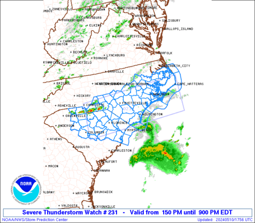
STATUS REPORT ON WW 231

SEVERE WEATHER THREAT CONTINUES RIGHT OF A LINE FROM 10 E SPA TO
35 SSW CLT TO 45 SSE CLT TO 40 NW FLO TO 35 NNW FLO TO 20 S SOP
TO 20 N FAY TO 15 NW GSB TO 20 E RWI TO 35 ESE RZZ.

..JEWELL..05/10/24

ATTN...WFO...RAH...MHX...ILM...GSP...CAE...


STATUS REPORT FOR WS 231

SEVERE WEATHER THREAT CONTINUES FOR THE FOLLOWING AREAS

NCC013-017-019-031-047-049-051-055-061-065-079-085-093-095-101-
103-107-117-129-133-137-141-147-155-163-165-177-187-191-195-
102140-

NC
.    NORTH CAROLINA COUNTIES INCLUDED ARE

BEAUFORT             BLADEN              BRUNSWICK
CARTERET             COLUMBUS            CRAVEN
CUMBERLAND           DARE                DUPLIN
EDGECOMBE            GREENE              HARNETT
HOKE                 HYDE                JOHNSTON
JONES                LENOIR              MARTIN
NEW HANOVER          ONSLOW              PAMLICO
PENDER               PITT                ROBESON
SAMPSON              SCOTLAND            TYRRELL
WASHINGTON           WAYNE               WILSON


SCC017-023-025-027-031-033-039-041-043-051-055-057-061-063-067-
069-071-079-085-087-089-102140-

SC
.    SOUTH CAROLINA COUNTIES INCLUDED ARE
https://www.spc.noaa.gov/products/watch/ws0231.html
date: 2024-05-10, from: NOAA tornado/severe thunderstorm watches, mesoscale discussions, convective outlooks, fire weather outlooks

URGENT - IMMEDIATE BROADCAST REQUESTED
Severe Thunderstorm Watch Number 231
NWS Storm Prediction Center Norman OK
150 PM EDT Fri May 10 2024

The NWS Storm Prediction Center has issued a

* Severe Thunderstorm Watch for portions of
  Southern and eastern North Carolina
  Northern and northeastern South Carolina
  Coastal Waters

* Effective this Friday afternoon and evening from 150 PM until
  900 PM EDT.

* Primary threats include...
  Scattered damaging wind gusts to 70 mph possible
  Scattered large hail events to 1.5 inches in diameter possible

SUMMARY...Scattered thunderstorm development is expected along and
ahead of a weak cold front/surface trough, starting near the North
Carolina/South Carolina border and then spreading eastward and
southeastward through the evening.  The storm environment will favor
a mix of supercells and bowing segments capable of producing large
hail of 1-1.5 inches in diameter and damaging gusts of 60-70 mph.

The severe thunderstorm watch area is approximately along and 60
statute miles north and south of a line from 55 miles south of
Charlotte NC to 30 miles south southeast of Cape Hatteras NC. For a
complete depiction of the watch see the associated watch outline
update (WOUS64 KWNS WOU1).

PRECAUTIONARY/PREPAREDNESS ACTIONS...

REMEMBER...A Severe Thunderstorm Watch means conditions are
favorable for severe thunderstorms in and close to the watch area.
Persons in these areas should be on the lookout for threatening
weather conditions and listen for later statements and possible
warnings. Severe thunderstorms can and occasionally do produce
tornadoes.

&&

AVIATION...A few severe thunderstorms with hail surface and aloft to
1.5 inches. Extreme turbulence and surface wind gusts to 60 knots. A
few cumulonimbi with maximum tops to 500. Mean storm motion vector
29030.

...Thompson
https://www.spc.noaa.gov/products/watch/ww0231.html
date: 2024-05-10, from: NOAA tornado/severe thunderstorm watches, mesoscale discussions, convective outlooks, fire weather outlooks

Day 1 Convective Outlook
NWS Storm Prediction Center Norman OK
0243 PM CDT Fri May 10 2024

Valid 102000Z - 111200Z

...THERE IS A SLIGHT RISK OF SEVERE THUNDERSTORMS ACROSS PORTIONS OF
THE CAROLINAS...

...SUMMARY...
Damaging winds of 60-70 mph and large hail of 1-1.75 inches remain
possible this afternoon/evening across southern North Carolina and
northeast South Carolina.

...Discussion...
Aside from some adjustments to the thunder lines to account for
current/evolving convection, no appreciable changes to the outlook
appear to be required at this time.

..Goss.. 05/10/2024

.PREV DISCUSSION... /ISSUED 1126 AM CDT Fri May 10 2024/

...Carolinas this afternoon/evening...
A midlevel shortwave trough over the OH Valley will move
southeastward to the Carolinas by this evening with an accompanying
surface cold front.  Surface heating in the wake of debris
cloudiness with the weakening MCS to the south and boundary-layer
dewpoints in the 60s will contribute to a corridor of moderate
buoyancy (MLCAPE near 1500 J/kg) ahead of the front.  Thunderstorm
development is expected by early-mid afternoon along and ahead of
the cold front and a diffuse pre-frontal trough across northern
SC/southern NC, and storms will subsequently spread southeastward
through this evening.  The moderate buoyancy, steepening low-level
lapse rates, and largely straight hodographs with ~50 kt midlevel
flow will favor damaging winds of 60-70 mph and isolated large hail
of 1-1.75 inches in diameter as the main threats with a mix of
supercells and line segments.

...Northeast Gulf coast and FL through this evening...
The initial MCS with damaging winds has now weakened and moved off
the Atlantic coast, with a band of elevated convection persisting to
the west in a zone of warm advection atop the trailing cold pool.
There will be a low-end hail threat with the elevated storms from
the FL Panhandle into north FL today, prior to the storms weakening
later this afternoon.  Additional storm development along the
outflow boundary across the FL peninsula is somewhat uncertain,
given the observed tendency for low-level flow to veer to
west-northwesterly across central FL which suggests only
weak/shallow ascent along the boundary.  Overall, any lingering
severe threat should remain marginal through the afternoon.

...Upper MS Valley...
A midlevel trough over northern MN will continue to dig
southeastward over the upper MS Valley through this evening.
Despite limited low-level moisture, surface heating/steepening
low-level lapse rates and ascent preceding the midlevel trough will
support a band of low-topped convection from mid afternoon through
late evening.  The stronger storms will be capable of producing
isolated wind damage

...Edwards Plateau in TX today...
Though an isolated/elevated storm could occur today well to the
north of the surface cold front, buoyancy appears fairly limited
where storm formation is more probable.  As such, severe storms
appear unlikely (and any storm splits off the high terrain in Mexico
are unlikely to remain severe after crossing the international
border).
https://www.spc.noaa.gov/products/outlook/day1otlk_2000.html
date: 2024-05-10, from: NOAA tornado/severe thunderstorm watches, mesoscale discussions, convective outlooks, fire weather outlooks

Mesoscale Discussion 0747
NWS Storm Prediction Center Norman OK
1205 PM CDT Fri May 10 2024

Areas affected...the central and eastern Carolinas

Concerning...Severe potential...Watch likely

Valid 101705Z - 101930Z

Probability of Watch Issuance...95 percent

SUMMARY...Scattered severe storms are likely to develop after 18Z
over the central Carolinas, producing damaging hail and wind through
early evening as they eventually exit the Atlantic Coast.

DISCUSSION...Surface analysis shows a deepening trough extending
from southeast VA across central NC and into northern SC, with
temperatures heating into the upper 70s F. Dewpoints remain in the
60s F, but may gradually mix down a few degrees by peak heating.

Morning soundings show steep midlevel lapse rates in place, as well
as ample deep-layer shear with mid to high level flow of 50 to 100
kt. This combination is resulting in a favorable environment for
large hail, and perhaps a few fast-moving bowing structures with
damaging winds.

As of 17Z, visible imagery is already showing developing towering CU
over northern SC and into central NC. The presence of cirrus from
the MCS to the south may have slowed heating a bit, but clearing
should continue, aiding destabilization.

Scattered to numerous storms are expected to form over the next few
hours along the boundary, with both cells and congealing line
segments possible. Some of the more isolated hail storms may produce
large amounts of 1.00 to 1.75" hail, with cold, severe downdrafts
possible as well.

..Jewell/Thompson.. 05/10/2024

...Please see www.spc.noaa.gov for graphic product...

ATTN...WFO...AKQ...MHX...RAH...ILM...CAE...GSP...

LAT...LON   36477580 36067555 35617536 35267540 34297619 33587712
            33267817 33177918 33237939 33558008 33958119 34068173
            34308213 34608220 34778200 34858121 35068026 35367944
            35677864 35867814 36307714 36477580
https://www.spc.noaa.gov/products/md/md0747.html
date: 2024-05-10, from: NOAA tornado/severe thunderstorm watches, mesoscale discussions, convective outlooks, fire weather outlooks

Day 2 Convective Outlook
NWS Storm Prediction Center Norman OK
1230 PM CDT Fri May 10 2024

Valid 111200Z - 121200Z

...THERE IS A MARGINAL RISK OF SEVERE THUNDERSTORMS ACROSS PORTIONS
OF SOUTHEASTERN NEW MEXICO AND WESTERN TEXAS...

...SUMMARY...
Isolated strong to severe thunderstorms may occur Saturday across
portions of the Trans-Pecos and Far West Texas.

...Synopsis...
Mid-level troughing initially over the Upper Great Lakes region is
forecast to shift eastward across the northeastern U.S. Saturday.
Meanwhile, a low over the southwestern states is forecast to shift
eastward across the Four Corners region through the period.

At the surface, a front will continue progressing eastward across
the western Atlantic, while lingering westward across the Florida
Peninsula and Gulf of Mexico, and then west-northwestward across far
West Texas and into New Mexico.  A second/weak front is forecast to
shift southward out of Canada into the northern Plains/Montana late.

...Southeastern New Mexico into western Texas...
Daytime heating of a modestly moist (upper 50s to low 60s dewpoints)
boundary layer across western Texas and into southeastern New
Mexico, in the vicinity of a stalled surface front, will result in
afternoon destabilization across this area.  By late afternoon peak
mixed-layer CAPE values should range from 500 to 1500 J/kg.  This --
combined with ascent provided by the frontal zone, and southeasterly
upslope near higher terrain -- should allow a few storms to develop.
With low-level southeasterlies beneath moderate mid-level
westerlies, shear sufficient for rotating updrafts suggests that a
couple of supercells will be possible, which may linger into the
evening while moving eastward toward the Concho Valley region of
Texas.  Large hail and locally damaging wind gusts would be possible
with the stronger storms, before diminishing by late evening.

..Goss.. 05/10/2024
https://www.spc.noaa.gov/products/outlook/day2otlk_1730.html
date: 2024-05-10, from: NOAA tornado/severe thunderstorm watches, mesoscale discussions, convective outlooks, fire weather outlooks
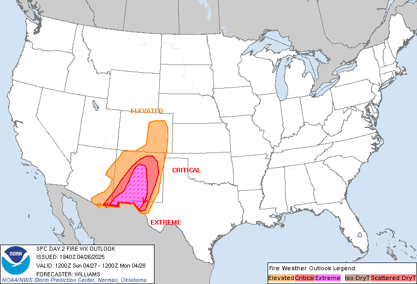
Day 2 Fire Weather Outlook
NWS Storm Prediction Center Norman OK
1224 PM CDT Fri May 10 2024

Valid 111200Z - 121200Z

Minor modifications were made to the Elevated area based on the
latest forecast guidance. Additionally, isolated dry thunderstorms
may develop over and near eastern portions of the Elevated area.
However, the probability of dry thunderstorms is low and confined to
a narrow corridor in south-central New Mexico, which precludes
introducing an Iso DryT area at this time. Otherwise, the previous
outlook remains on track.

..Nauslar.. 05/10/2024

.PREV DISCUSSION... /ISSUED 0159 AM CDT Fri May 10 2024/

...Synopsis...
A mid-level trough will eject into the Atlantic as a second
mid-level trough ejects into the Southern Plains tomorrow
(Saturday). Surface high pressure will become established over the
eastern U.S., promoting cool conditions while potentially
appreciable rainfall occurs over the southern High Plains. As such,
wildfire-spread concerns will be limited across most of the CONUS.
Guidance consensus does suggest that 15+ mph sustained westerly
surface winds will overspread 10-20 percent RH along the southern
Arizona and New Mexico border area during the afternoon, where
Elevated highlights have been introduced. Otherwise, locally dry or
breezy conditions may prevail over the northern Plains or Florida
Peninsula, where localized wildfire-spread potential may exist.

...Please see www.spc.noaa.gov/fire for graphic product...
https://www.spc.noaa.gov/products/fire_wx/fwdy2.html
date: 2024-05-10, from: NOAA tornado/severe thunderstorm watches, mesoscale discussions, convective outlooks, fire weather outlooks

Day 1 Convective Outlook
NWS Storm Prediction Center Norman OK
1126 AM CDT Fri May 10 2024

Valid 101630Z - 111200Z

...THERE IS A SLIGHT RISK OF SEVERE THUNDERSTORMS THIS
AFTERNOON/EVENING FOR SOUTHERN NC/NORTHEAST SC...

...SUMMARY...
Damaging winds of 60-70 mph and large hail of 1-1.75 inches in
diameter will be possible this afternoon/evening across southern
North Carolina and northeast South Carolina.

...Carolinas this afternoon/evening...
A midlevel shortwave trough over the OH Valley will move
southeastward to the Carolinas by this evening with an accompanying
surface cold front.  Surface heating in the wake of debris
cloudiness with the weakening MCS to the south and boundary-layer
dewpoints in the 60s will contribute to a corridor of moderate
buoyancy (MLCAPE near 1500 J/kg) ahead of the front.  Thunderstorm
development is expected by early-mid afternoon along and ahead of
the cold front and a diffuse pre-frontal trough across northern
SC/southern NC, and storms will subsequently spread southeastward
through this evening.  The moderate buoyancy, steepening low-level
lapse rates, and largely straight hodographs with ~50 kt midlevel
flow will favor damaging winds of 60-70 mph and isolated large hail
of 1-1.75 inches in diameter as the main threats with a mix of
supercells and line segments.

...Northeast Gulf coast and FL through this evening...
The initial MCS with damaging winds has now weakened and moved off
the Atlantic coast, with a band of elevated convection persisting to
the west in a zone of warm advection atop the trailing cold pool.
There will be a low-end hail threat with the elevated storms from
the FL Panhandle into north FL today, prior to the storms weakening
later this afternoon.  Additional storm development along the
outflow boundary across the FL peninsula is somewhat uncertain,
given the observed tendency for low-level flow to veer to
west-northwesterly across central FL which suggests only
weak/shallow ascent along the boundary.  Overall, any lingering
severe threat should remain marginal through the afternoon.

...Upper MS Valley...
A midlevel trough over northern MN will continue to dig
southeastward over the upper MS Valley through this evening.
Despite limited low-level moisture, surface heating/steepening
low-level lapse rates and ascent preceding the midlevel trough will
support a band of low-topped convection from mid afternoon through
late evening.  The stronger storms will be capable of producing
isolated wind damage

...Edwards Plateau in TX today...
Though an isolated/elevated storm could occur today well to the
north of the surface cold front, buoyancy appears fairly limited
where storm formation is more probable.  As such, severe storms
appear unlikely (and any storm splits off the high terrain in Mexico
are unlikely to remain severe after crossing the international
border).

..Thompson/Thornton.. 05/10/2024
https://www.spc.noaa.gov/products/outlook/day1otlk_1630.html
date: 2024-05-10, from: NOAA tornado/severe thunderstorm watches, mesoscale discussions, convective outlooks, fire weather outlooks

Day 1 Fire Weather Outlook
NWS Storm Prediction Center Norman OK
1028 AM CDT Fri May 10 2024

Valid 101700Z - 111200Z

No changes are warranted and please see previous discussion.

..Nauslar.. 05/10/2024

.PREV DISCUSSION... /ISSUED 0158 AM CDT Fri May 10 2024/

...Synopsis...
An upper low will meander over the Southwest as a mid-level trough
amplifies over the eastern U.S. today, with northwest flow aloft
prevailing everywhere east of the Mississippi River. As such,
relatively cool conditions will prevail over much of the CONUS, with
significant wildfire-spread potential expected to be limited over
most locations. One exception may be central and eastern portions of
the Florida Peninsula, where 10-15 mph sustained westerly surface
winds, amid 25-35 percent RH, may overspread dry fuels during the
afternoon, warranting Elevated highlights.

A few other areas may also experience localized conditions favorable
for wildfire growth. First, dry and occasionally breezy conditions
may overlap modestly receptive fuels over parts of southeast Arizona
into far southwestern New Mexico, which may promote locally Elevated
fire concerns during the afternoon. Second, dry northerly surface
winds will overspread the northern Plains behind the cold front,
though any wildfire-spread that materializes should be localized
given marginally receptive fuels.

...Please see www.spc.noaa.gov/fire for graphic product...
https://www.spc.noaa.gov/products/fire_wx/fwdy1.html
date: 2024-05-10, from: NOAA tornado/severe thunderstorm watches, mesoscale discussions, convective outlooks, fire weather outlooks
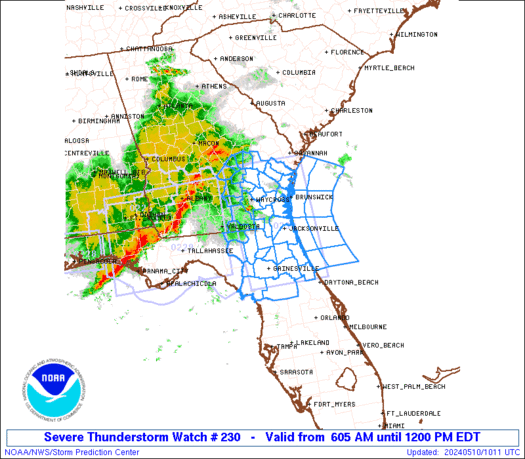
STATUS REPORT ON WW 230

SEVERE WEATHER THREAT CONTINUES RIGHT OF A LINE FROM 30 SSW CTY
TO 15 SSW GNV TO 30 E GNV TO 20 S JAX TO 15 W SSI TO 30 N SSI TO
35 E SAV.

..JEWELL..05/10/24

ATTN...WFO...JAX...TBW...CHS...FFC...


STATUS REPORT FOR WS 230

SEVERE WEATHER THREAT CONTINUES FOR THE FOLLOWING AREAS

FLC019-031-035-083-089-107-109-101440-

FL
.    FLORIDA COUNTIES INCLUDED ARE

CLAY                 DUVAL               FLAGLER
MARION               NASSAU              PUTNAM
ST. JOHNS


GAC039-127-191-101440-

GA
.    GEORGIA COUNTIES INCLUDED ARE

CAMDEN               GLYNN               MCINTOSH


AMZ354-374-450-452-454-470-472-474-101440-

CW

.    ADJACENT COASTAL WATERS INCLUDED ARE
https://www.spc.noaa.gov/products/watch/ws0230.html
date: 2024-05-09, from: NOAA tornado/severe thunderstorm watches, mesoscale discussions, convective outlooks, fire weather outlooks
No Mesoscale Discussions are in effect as of Thu May 9 19:30:09 UTC 2024.
https://www.spc.noaa.gov/products/md/
date: 2024-05-09, from: NOAA tornado/severe thunderstorm watches, mesoscale discussions, convective outlooks, fire weather outlooks
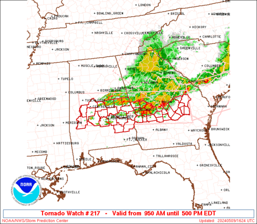
STATUS REPORT ON WW 217

SEVERE WEATHER THREAT CONTINUES RIGHT OF A LINE FROM 30 SSW SEM
TO 20 NNE SEM TO 10 ESE LGC.

..BENTLEY..05/09/24

ATTN...WFO...BMX...FFC...


STATUS REPORT FOR WT 217

SEVERE WEATHER THREAT CONTINUES FOR THE FOLLOWING AREAS

ALC001-005-011-051-081-085-087-101-109-113-092040-

AL
.    ALABAMA COUNTIES INCLUDED ARE

AUTAUGA              BARBOUR             BULLOCK
ELMORE               LEE                 LOWNDES
MACON                MONTGOMERY          PIKE
RUSSELL


GAC023-053-081-091-093-107-145-175-193-197-209-215-235-249-259-
261-263-269-271-279-283-307-309-315-092040-

GA
.    GEORGIA COUNTIES INCLUDED ARE

BLECKLEY             CHATTAHOOCHEE       CRISP
DODGE                DOOLY               EMANUEL
HARRIS               LAURENS             MACON
MARION               MONTGOMERY          MUSCOGEE
PULASKI              SCHLEY              STEWART
SUMTER               TALBOT              TAYLOR
TELFAIR              TOOMBS              TREUTLEN
WEBSTER              WHEELER             WILCOX
https://www.spc.noaa.gov/products/watch/ws0217.html
date: 2024-05-09, from: NOAA tornado/severe thunderstorm watches, mesoscale discussions, convective outlooks, fire weather outlooks

URGENT - IMMEDIATE BROADCAST REQUESTED
Tornado Watch Number 217
NWS Storm Prediction Center Norman OK
950 AM EDT Thu May 9 2024

The NWS Storm Prediction Center has issued a

* Tornado Watch for portions of
  Central and Eastern Alabama
  Central Georgia

* Effective this Thursday morning and afternoon from 950 AM until
  500 PM EDT.

* Primary threats include...
  A couple tornadoes possible
  Widespread damaging wind gusts to 70 mph likely
  Scattered large hail likely with isolated very large hail events
    to 2 inches in diameter possible

SUMMARY...Bands of strong to severe storms will likely continue to
push east-southeast across the Watch area through the early to mid
afternoon.  A few supercells are possible ahead of the main
thunderstorm bands and will also pose a severe risk, including the
threat for tornadoes and large hail.  Damaging gusts will be the
primary hazard with the thunderstorm bands, but a tornado may also
accompany any embedded stronger circulations within the line.

The tornado watch area is approximately along and 50 statute miles
north and south of a line from 30 miles south southwest of
Tuscaloosa AL to 15 miles east northeast of Vidalia GA. For a
complete depiction of the watch see the associated watch outline
update (WOUS64 KWNS WOU7).

PRECAUTIONARY/PREPAREDNESS ACTIONS...

REMEMBER...A Tornado Watch means conditions are favorable for
tornadoes and severe thunderstorms in and close to the watch
area. Persons in these areas should be on the lookout for
threatening weather conditions and listen for later statements
and possible warnings.

&&

OTHER WATCH INFORMATION...CONTINUE...WW 215...WW 216...

AVIATION...Tornadoes and a few severe thunderstorms with hail
surface and aloft to 2 inches. Extreme turbulence and surface wind
gusts to 60 knots. A few cumulonimbi with maximum tops to 500. Mean
storm motion vector 26035.

...Smith
https://www.spc.noaa.gov/products/watch/ww0217.html
date: 2024-05-09, from: NOAA tornado/severe thunderstorm watches, mesoscale discussions, convective outlooks, fire weather outlooks

URGENT - IMMEDIATE BROADCAST REQUESTED
Tornado Watch Number 218
NWS Storm Prediction Center Norman OK
1210 PM EDT Thu May 9 2024

The NWS Storm Prediction Center has issued a

* Tornado Watch for portions of
  Southeast Georgia
  Southern South Carolina
  Coastal Waters

* Effective this Thursday afternoon and evening from 1210 PM
  until 700 PM EDT.

* Primary threats include...
  A couple tornadoes possible
  Scattered damaging wind gusts to 70 mph likely
  Isolated large hail events to 1.5 inches in diameter possible

SUMMARY...Intensifying bands of storms will move into the Watch area
this afternoon and into the early evening.  The stronger storms will
probably include a mix of line segments and a few supercells.  The
more intense storms will potentially be capable of damaging gusts
and a couple of tornadoes.

The tornado watch area is approximately along and 55 statute miles
north and south of a line from 60 miles west northwest of Savannah
GA to 35 miles east southeast of Charleston SC. For a complete
depiction of the watch see the associated watch outline update
(WOUS64 KWNS WOU8).

PRECAUTIONARY/PREPAREDNESS ACTIONS...

REMEMBER...A Tornado Watch means conditions are favorable for
tornadoes and severe thunderstorms in and close to the watch
area. Persons in these areas should be on the lookout for
threatening weather conditions and listen for later statements
and possible warnings.

&&

OTHER WATCH INFORMATION...CONTINUE...WW 216...WW 217...

AVIATION...Tornadoes and a few severe thunderstorms with hail
surface and aloft to 1.5 inches. Extreme turbulence and surface wind
gusts to 60 knots. A few cumulonimbi with maximum tops to 500. Mean
storm motion vector 26035.

...Smith
https://www.spc.noaa.gov/products/watch/ww0218.html
date: 2024-05-09, from: NOAA tornado/severe thunderstorm watches, mesoscale discussions, convective outlooks, fire weather outlooks

STATUS REPORT ON WW 218

SEVERE WEATHER THREAT CONTINUES RIGHT OF A LINE FROM 20 SSE VDI
TO 20 NW SAV TO 35 WSW CHS TO 40 E CHS.

..BENTLEY..05/09/24

ATTN...WFO...CHS...


STATUS REPORT FOR WT 218

SEVERE WEATHER THREAT CONTINUES FOR THE FOLLOWING AREAS

GAC029-051-103-179-183-191-267-092040-

GA
.    GEORGIA COUNTIES INCLUDED ARE

BRYAN                CHATHAM             EFFINGHAM
LIBERTY              LONG                MCINTOSH
TATTNALL


SCC013-019-029-053-092040-

SC
.    SOUTH CAROLINA COUNTIES INCLUDED ARE

BEAUFORT             CHARLESTON          COLLETON
JASPER


AMZ330-350-352-354-092040-

CW

.    ADJACENT COASTAL WATERS INCLUDED ARE
https://www.spc.noaa.gov/products/watch/ws0218.html
date: 2024-05-09, from: NOAA tornado/severe thunderstorm watches, mesoscale discussions, convective outlooks, fire weather outlooks

URGENT - IMMEDIATE BROADCAST REQUESTED
Severe Thunderstorm Watch Number 219
NWS Storm Prediction Center Norman OK
1225 PM CDT Thu May 9 2024

The NWS Storm Prediction Center has issued a

* Severe Thunderstorm Watch for portions of
  Southern Oklahoma
  North Texas

* Effective this Thursday afternoon and evening from 1225 PM
  until 700 PM CDT.

* Primary threats include...
  Scattered large hail and isolated very large hail events to 3.5
    inches in diameter likely
  Scattered damaging wind gusts to 70 mph possible

SUMMARY...Several supercells are forecast to move across the Watch
area this afternoon into the early evening.  Large to giant hail
will be likely with any robust supercell and severe gusts are also
possible.

The severe thunderstorm watch area is approximately along and 55
statute miles north and south of a line from 30 miles southwest of
Wichita Falls TX to 30 miles east southeast of Durant OK. For a
complete depiction of the watch see the associated watch outline
update (WOUS64 KWNS WOU9).

PRECAUTIONARY/PREPAREDNESS ACTIONS...

REMEMBER...A Severe Thunderstorm Watch means conditions are
favorable for severe thunderstorms in and close to the watch area.
Persons in these areas should be on the lookout for threatening
weather conditions and listen for later statements and possible
warnings. Severe thunderstorms can and occasionally do produce
tornadoes.

&&

OTHER WATCH INFORMATION...CONTINUE...WW 217...WW 218...

AVIATION...A few severe thunderstorms with hail surface and aloft to
3.5 inches. Extreme turbulence and surface wind gusts to 60 knots. A
few cumulonimbi with maximum tops to 500. Mean storm motion vector
24030.

...Smith
https://www.spc.noaa.gov/products/watch/ww0219.html
date: 2024-05-09, from: NOAA tornado/severe thunderstorm watches, mesoscale discussions, convective outlooks, fire weather outlooks

STATUS REPORT ON WW 219

THE SEVERE WEATHER THREAT CONTINUES ACROSS THE ENTIRE WATCH AREA.

..BENTLEY..05/09/24

ATTN...WFO...OUN...FWD...


STATUS REPORT FOR WS 219

SEVERE WEATHER THREAT CONTINUES FOR THE FOLLOWING AREAS

OKC005-013-019-033-067-069-085-095-099-137-092040-

OK
.    OKLAHOMA COUNTIES INCLUDED ARE

ATOKA                BRYAN               CARTER
COTTON               JEFFERSON           JOHNSTON
LOVE                 MARSHALL            MURRAY
STEPHENS


TXC009-077-085-097-121-147-181-237-337-485-497-503-092040-

TX
.    TEXAS COUNTIES INCLUDED ARE

ARCHER               CLAY                COLLIN
COOKE                DENTON              FANNIN
GRAYSON              JACK                MONTAGUE
WICHITA              WISE                YOUNG


THE WATCH STATUS MESSAGE IS FOR GUIDANCE PURPOSES ONLY.  PLEASE
REFER TO WATCH COUNTY NOTIFICATION STATEMENTS FOR OFFICIAL
INFORMATION ON COUNTIES...INDEPENDENT CITIES AND MARINE ZONES
CLEARED FROM SEVERE THUNDERSTORM AND TORNADO WATCHES.
https://www.spc.noaa.gov/products/watch/ws0219.html
date: 2024-05-09, from: NOAA tornado/severe thunderstorm watches, mesoscale discussions, convective outlooks, fire weather outlooks

URGENT - IMMEDIATE BROADCAST REQUESTED
Tornado Watch Number 220
NWS Storm Prediction Center Norman OK
145 PM EDT Thu May 9 2024

The NWS Storm Prediction Center has issued a

* Tornado Watch for portions of
  Southeast Alabama
  Northeast Florida
  Southern Georgia
  Coastal Waters

* Effective this Thursday afternoon and evening from 145 PM until
  900 PM EDT.

* Primary threats include...
  A couple tornadoes possible
  Scattered damaging wind gusts to 70 mph likely
  Isolated large hail events to 1.5 inches in diameter possible

SUMMARY...Several strong to severe thunderstorm bands will likely
progressively move east-southeastward into the Watch area this
afternoon and early evening.  In addition to the possibility for
damaging gusts with the thunderstorm bands, embedded supercells or
embedded mesovortices may pose a tornado risk.

The tornado watch area is approximately along and 40 statute miles
north and south of a line from 25 miles northwest of Dothan AL to 30
miles southeast of Brunswick GA. For a complete depiction of the
watch see the associated watch outline update (WOUS64 KWNS WOU0).

PRECAUTIONARY/PREPAREDNESS ACTIONS...

REMEMBER...A Tornado Watch means conditions are favorable for
tornadoes and severe thunderstorms in and close to the watch
area. Persons in these areas should be on the lookout for
threatening weather conditions and listen for later statements
and possible warnings.

&&

OTHER WATCH INFORMATION...CONTINUE...WW 217...WW 218...WW 219...

AVIATION...Tornadoes and a few severe thunderstorms with hail
surface and aloft to 1.5 inches. Extreme turbulence and surface wind
gusts to 60 knots. A few cumulonimbi with maximum tops to 500. Mean
storm motion vector 27035.

...Smith
https://www.spc.noaa.gov/products/watch/ww0220.html
date: 2024-05-09, from: NOAA tornado/severe thunderstorm watches, mesoscale discussions, convective outlooks, fire weather outlooks

STATUS REPORT ON WW 220

THE SEVERE WEATHER THREAT CONTINUES ACROSS THE ENTIRE WATCH AREA.

..BENTLEY..05/09/24

ATTN...WFO...TAE...JAX...


STATUS REPORT FOR WT 220

SEVERE WEATHER THREAT CONTINUES FOR THE FOLLOWING AREAS

ALC045-067-069-092040-

AL
.    ALABAMA COUNTIES INCLUDED ARE

DALE                 HENRY               HOUSTON


FLC031-089-092040-

FL
.    FLORIDA COUNTIES INCLUDED ARE

DUVAL                NASSAU


GAC001-003-005-007-017-019-025-027-037-039-049-061-065-069-071-
075-087-095-099-101-127-131-155-161-173-177-185-201-205-229-239-
243-253-273-275-277-287-299-305-321-092040-

GA
.    GEORGIA COUNTIES INCLUDED ARE

APPLING              ATKINSON            BACON
BAKER                BEN HILL            BERRIEN
BRANTLEY             BROOKS              CALHOUN
https://www.spc.noaa.gov/products/watch/ws0220.html
date: 2024-05-09, from: NOAA tornado/severe thunderstorm watches, mesoscale discussions, convective outlooks, fire weather outlooks
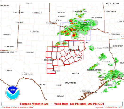
URGENT - IMMEDIATE BROADCAST REQUESTED
Tornado Watch Number 221
NWS Storm Prediction Center Norman OK
135 PM CDT Thu May 9 2024

The NWS Storm Prediction Center has issued a

* Tornado Watch for portions of
  North-Central and Central Texas

* Effective this Thursday afternoon and evening from 135 PM until
  900 PM CDT.

* Primary threats include...
  A couple tornadoes possible
  Scattered damaging winds and isolated significant gusts to 85
    mph likely
  Scattered large hail and isolated very large hail events to 4
    inches in diameter likely

SUMMARY...Widely scattered to scattered thunderstorms are forecast
to develop this afternoon into the early evening.  Several intense
supercells are likely and will be capable of large to giant hail
(max diameter 2 to 4 inches) and severe gusts.  The tornado risk may
focus along the west to east oriented wind shift draped across parts
of north-central Texas.  Eventual growth into a severe cluster of
supercells with accompanying significant hail and wind hazards may
evolve towards the evening.

The tornado watch area is approximately along and 65 statute miles
north and south of a line from 35 miles south southeast of Dallas TX
to 70 miles south southwest of Abilene TX. For a complete depiction
of the watch see the associated watch outline update (WOUS64 KWNS
WOU1).

PRECAUTIONARY/PREPAREDNESS ACTIONS...

REMEMBER...A Tornado Watch means conditions are favorable for
tornadoes and severe thunderstorms in and close to the watch
area. Persons in these areas should be on the lookout for
threatening weather conditions and listen for later statements
and possible warnings.

&&

OTHER WATCH INFORMATION...CONTINUE...WW 217...WW 218...WW
219...WW 220...

AVIATION...Tornadoes and a few severe thunderstorms with hail
surface and aloft to 4 inches. Extreme turbulence and surface wind
gusts to 75 knots. A few cumulonimbi with maximum tops to 500. Mean
storm motion vector 27025.

...Smith
https://www.spc.noaa.gov/products/watch/ww0221.html
date: 2024-05-09, from: NOAA tornado/severe thunderstorm watches, mesoscale discussions, convective outlooks, fire weather outlooks

STATUS REPORT ON WW 221

THE SEVERE WEATHER THREAT CONTINUES ACROSS THE ENTIRE WATCH AREA.

..BENTLEY..05/09/24

ATTN...WFO...FWD...SJT...


STATUS REPORT FOR WT 221

SEVERE WEATHER THREAT CONTINUES FOR THE FOLLOWING AREAS

TXC035-049-059-083-093-095-099-113-133-139-143-193-217-221-251-
267-281-307-309-319-327-333-363-367-399-411-417-425-429-439-441-
092040-

TX
.    TEXAS COUNTIES INCLUDED ARE

BOSQUE               BROWN               CALLAHAN
COLEMAN              COMANCHE            CONCHO
CORYELL              DALLAS              EASTLAND
ELLIS                ERATH               HAMILTON
HILL                 HOOD                JOHNSON
KIMBLE               LAMPASAS            MCCULLOCH
MCLENNAN             MASON               MENARD
MILLS                PALO PINTO          PARKER
RUNNELS              SAN SABA            SHACKELFORD
SOMERVELL            STEPHENS            TARRANT
TAYLOR


THE WATCH STATUS MESSAGE IS FOR GUIDANCE PURPOSES ONLY.  PLEASE
REFER TO WATCH COUNTY NOTIFICATION STATEMENTS FOR OFFICIAL
INFORMATION ON COUNTIES...INDEPENDENT CITIES AND MARINE ZONES
CLEARED FROM SEVERE THUNDERSTORM AND TORNADO WATCHES.
https://www.spc.noaa.gov/products/watch/ws0221.html
date: 2024-05-09, from: NOAA tornado/severe thunderstorm watches, mesoscale discussions, convective outlooks, fire weather outlooks

STATUS REPORT ON WW 216

SEVERE WEATHER THREAT CONTINUES RIGHT OF A LINE FROM 25 ENE LGC
TO 20 NNE MCN TO 25 WSW AGS.

..BENTLEY..05/09/24

ATTN...WFO...FFC...CAE...GSP...MRX...


STATUS REPORT FOR WT 216

SEVERE WEATHER THREAT CONTINUES FOR THE FOLLOWING AREAS

GAC009-021-033-079-125-153-163-169-171-199-207-225-231-285-289-
293-303-319-091740-

GA
.    GEORGIA COUNTIES INCLUDED ARE

BALDWIN              BIBB                BURKE
CRAWFORD             GLASCOCK            HOUSTON
JEFFERSON            JONES               LAMAR
MERIWETHER           MONROE              PEACH
PIKE                 TROUP               TWIGGS
UPSON                WASHINGTON          WILKINSON


SCC009-011-027-075-091740-

SC
.    SOUTH CAROLINA COUNTIES INCLUDED ARE

BAMBERG              BARNWELL            CLARENDON
ORANGEBURG


THE WATCH STATUS MESSAGE IS FOR GUIDANCE PURPOSES ONLY.  PLEASE
REFER TO WATCH COUNTY NOTIFICATION STATEMENTS FOR OFFICIAL
https://www.spc.noaa.gov/products/watch/ws0216.html
date: 2024-05-09, from: NOAA tornado/severe thunderstorm watches, mesoscale discussions, convective outlooks, fire weather outlooks
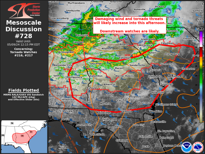
Mesoscale Discussion 0728
NWS Storm Prediction Center Norman OK
0939 AM CDT Thu May 09 2024

Areas affected...central/eastern SC...central/south GA...southeast
AL

Concerning...Tornado Watch 216...217...

Valid 091439Z - 091615Z

The severe weather threat for Tornado Watch 216, 217 continues.

SUMMARY...Leading convective line across the Savannah Valley may
necessitate an additional downstream watch issuance into the coastal
plain of South Carolina and Georgia in the near-term. Greater severe
potential is expected to evolve from upstream clusters and lines
shifting east-southeast from eastern Alabama, with likely watch
issuance into south Georgia.

DISCUSSION...A leading line of storms across parts of the Savannah
Valley into the SC Midlands has struggled to intensify with measured
gusts holding below 30 mph. However, full boundary-layer heating is
underway downstream to the coast. This coupled with a favorable low
to deep-layer shear environment per CAE VWP data will support
probable intensification of this line as it approaches the coastal
plain through early afternoon. An increase in damaging wind
potential, as well as brief embedded tornadoes may occur.

More prominent severe potential should emanate out of initially
semi-discrete supercells across parts of south AL spreading east of
the Chattahoochee River into GA, as well as an organized linear
cluster moving southeast from east-central AL. It appears likely
that further upscale growth will occur into this afternoon, yielding
a broader linear cluster/QLCS pushing southeast across much of
central and south GA.

..Grams.. 05/09/2024

...Please see www.spc.noaa.gov for graphic product...

ATTN...WFO...ILM...CHS...CAE...JAX...FFC...TAE...BMX...

LAT...LON   34028110 33908025 33977974 33857919 33557909 33157926
            31708116 31078167 30868350 30988488 31518587 32598617
            33098591 33388499 33248352 33478229 34028110
https://www.spc.noaa.gov/products/md/md0728.html
date: 2024-05-09, from: NOAA tornado/severe thunderstorm watches, mesoscale discussions, convective outlooks, fire weather outlooks

URGENT - IMMEDIATE BROADCAST REQUESTED
Tornado Watch Number 216
NWS Storm Prediction Center Norman OK
545 AM EDT Thu May 9 2024

The NWS Storm Prediction Center has issued a

* Tornado Watch for portions of
  Northern and central Georgia
  Extreme western North Carolina
  Extreme southeastern Tennessee

* Effective this Thursday morning and afternoon from 545 AM until
  100 PM EDT.

* Primary threats include...
  A couple tornadoes possible
  Scattered damaging wind gusts to 70 mph likely
  Isolated large hail events to 1.5 inches in diameter possible

SUMMARY...An organizing complex of severe thunderstorms is expected
to move southeastward astride an outflow boundary from prior
activity.  This will focus a corridor of damaging-wind potential,
with a few tornadoes and isolated severe hail possible through the
rest of the morning.

The tornado watch area is approximately along and 60 statute miles
either side of a line from 45 miles north of Rome GA to 55 miles
east northeast of Macon GA. For a complete depiction of the watch
see the associated watch outline update (WOUS64 KWNS WOU6).

PRECAUTIONARY/PREPAREDNESS ACTIONS...

REMEMBER...A Tornado Watch means conditions are favorable for
tornadoes and severe thunderstorms in and close to the watch
area. Persons in these areas should be on the lookout for
threatening weather conditions and listen for later statements
and possible warnings.

&&

OTHER WATCH INFORMATION...CONTINUE...WW 215...

AVIATION...Tornadoes and a few severe thunderstorms with hail
surface and aloft to 1.5 inches. Extreme turbulence and surface wind
gusts to 60 knots. A few cumulonimbi with maximum tops to 500. Mean
storm motion vector 31035.

...Edwards
https://www.spc.noaa.gov/products/watch/ww0216.html
date: 2024-05-09, from: NOAA tornado/severe thunderstorm watches, mesoscale discussions, convective outlooks, fire weather outlooks
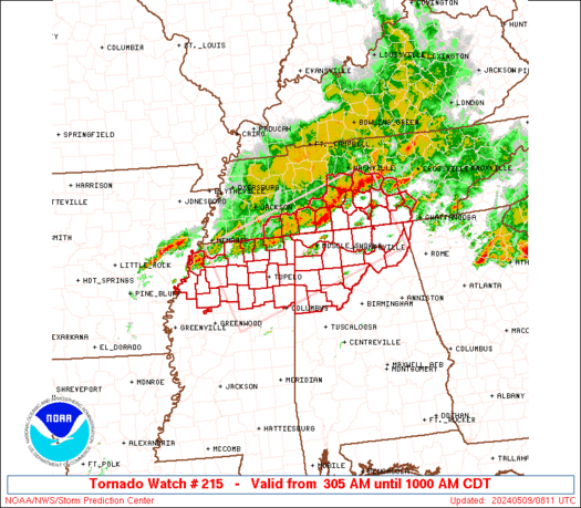
STATUS REPORT ON WW 215

SEVERE WEATHER THREAT CONTINUES RIGHT OF A LINE FROM 20 ENE CBM
TO 30 WSW CHA.

FOR ADDITIONAL INFORMATION SEE MESOSCALE DISCUSSION 0727.

..GRAMS..05/09/24

ATTN...WFO...HUN...BMX...FFC...MEG...OHX...MRX...


STATUS REPORT FOR WT 215

SEVERE WEATHER THREAT CONTINUES FOR THE FOLLOWING AREAS

ALC009-015-019-027-029-043-049-055-057-073-095-107-111-115-117-
121-125-127-091440-

AL
.    ALABAMA COUNTIES INCLUDED ARE

BLOUNT               CALHOUN             CHEROKEE
CLAY                 CLEBURNE            CULLMAN
DEKALB               ETOWAH              FAYETTE
JEFFERSON            MARSHALL            PICKENS
RANDOLPH             ST. CLAIR           SHELBY
TALLADEGA            TUSCALOOSA          WALKER


THE WATCH STATUS MESSAGE IS FOR GUIDANCE PURPOSES ONLY.  PLEASE
REFER TO WATCH COUNTY NOTIFICATION STATEMENTS FOR OFFICIAL
INFORMATION ON COUNTIES...INDEPENDENT CITIES AND MARINE ZONES
CLEARED FROM SEVERE THUNDERSTORM AND TORNADO WATCHES.
https://www.spc.noaa.gov/products/watch/ws0215.html
date: 2024-05-09, from: NOAA tornado/severe thunderstorm watches, mesoscale discussions, convective outlooks, fire weather outlooks

Day 1 Convective Outlook CORR 1
NWS Storm Prediction Center Norman OK
0823 AM CDT Thu May 09 2024

Valid 091300Z - 101200Z

...THERE IS AN ENHANCED RISK OF SEVERE THUNDERSTORMS FROM CENTRAL
TEXAS TO PARTS OF THE GEORGIA/SOUTH CAROLINA COAST...

CORRECTED FOR INCORRECT SLGT LABEL LOCATION

...SUMMARY...
Very large hail with multiple supercells appears probable across
parts of north and central Texas into the ArkLaTex vicinity this
afternoon and evening -- including parts of the Dallas/Ft. Worth
Metroplex.  A broader corridor of severe hail and damaging-wind
potential will extend from east Texas into the lower Mississippi
Valley and Southeast.

...Synopsis...
In mid/upper levels, an extraordinarily long, more than continent-
spanning, positively tilted trough was apparent in moisture-channel
imagery.  The trough extended from an Atlantic cyclone south-
southeast of Greenland, across Newfoundland/southern Labrador and
southern parts of QC/ON, the Upper Great Lakes, upper Mississippi
Valley, NE, the central Rockies, southern Great Basin, central CA,
and west-southwestward over the Pacific.  On the western segment of
the trough, a remnant cyclone near FSD/YKN will dissipate shortly,
while a closed vortex develops over UT and slowly retrogrades
through the period.  Meanwhile, weak shortwave troughs now over
parts of MO/IA/IL will move eastward across the Ohio Valley region,
in advance of a larger, amplifying shortwave trough now over Lake
Superior and northeastern MN.  A weak, but still potentially
influential southern stream shortwave will move east-northeastward
from southwest to central TX today.  Picking up some convective
vorticity and related amplification, this perturbation should
accelerate eastward and reach parts of AL by 12Z tomorrow.

At the surface, 11Z analysis showed a diffuse frontal-wave low over
central IL, with quasistationary to locally warm front eastward
across central/southern OH to northern WV.  A cold front extended
from the low across southern IL to eastern AR, becoming wavy/
quasistationary through a weak low south of ABI, then cold again
into the Big Bend region.  This front, overall, will sag southward
across TX through the period, but hang up for much of the day ahead
of the low and around the DFW/SEP region, and across the Edwards
Plateau.  The Ohio Valley low is expected to move eastward to near
the southwestern corner of PA by 00Z, then move/redevelop eastward
across VA to near the Delmarva Atlantic Coast by the end of the
period.

...North, central and east TX...
At least a few supercells are expected to erupt in a high-
instability environment this afternoon, along and southeast of the
front.  This activity will be capable of large hail -- some of it
potentially 3+ inches in diameter -- as well as locally severe gusts
and perhaps a tornado or two.  The threat area includes the DFW
Metroplex -- unfortunately, no stranger to swaths of destructive
hail -- and areas southward/eastward into the Hill Country, I-35/45
corridors and Piney Woods.

The airmass across the region begins the day quite moist, with
surface dewpoints commonly in the low/mid 70s just southeast of the
front, and mid/upper 70s over the Gulf Coastal Plain.  Steep
midlevel lapse rates, related to an EML, were sampled by 12Z RAOBs
at MAF and FWD.  This airmass aloft will remain over the region,
with some subtle/reinforcing large-scale ascent possible ahead of
the southern-stream perturbation.  Meanwhile, the boundary layer
should destabilize amidst strong diurnal heating, causing the cap to
weaken considerably through early/mid afternoon.  Development is
possible as soon as late morning to midday near the front, over the
Edwards Plateau, and midday to mid afternoon farther north near the
low.  By then, 3500-4500 J/kg MLCAPE should be common, locally near
5000 J/kg.  Low-level flow should remain weak, but with enough
easterly component southeast of the front to foster strong veering
with height and long (sometimes nearly straight) hodographs.  This
will support splitting storms, with both left- and right-moving
supercells offering the threat for significant (2+ inch) hail.
Sustained storms could produce 3-4-inch hailstones, based on
historic analogs and a 2D hail model applied to forecast soundings.

With a deep troposphere and abundant inflow-layer moisture, deeply
precip-loaded downdrafts are possible, with some midlevel momentum
augmentation and related severe-gust potential.  The wind threat
could evolve upscale and start forward-propagating eastward into LA
wherever early cells can aggregate into clusters.  The supercell
tornado threat is conditional, mainly dependent on local storm-scale
processes such as mergers and boundary interactions.  QLCS tornadoes
are also possible with any MCS.

...Lower Mississippi Valley to southern Atlantic Coast...
Ongoing, organized areas of thunderstorms over the Southeast,
interacting with and focused astride baroclinic/instability
gradients from outflow boundaries, will continue to offer damaging
wind, a few tornadoes, and isolated severe hail through at least
midday as they move across parts of northern MS, AL, territory
eastward/southeastward toward the GA/SC coast, and perhaps northern
FL.  For near-term concerns, refer to tornado watches 215-216 and
related mesoscale discussions.

The related outflow/baroclinic gradient should serve as a focus for
forward propagation, and perhaps initiation, of thunderstorms this
afternoon into tonight.  Surface dewpoints commonly in the 70s F and
strong diurnal heating south and west of the outflow boundaries will
contribute to peak afternoon MLCAPE of 3500-4500 J/kg, only slowly
diminishing through the evening and overnight hours.  Given the very
richly moist and favorable unstable environment in place, beneath
parallel-oriented midlevel flow, one or two organized MCSs may
result.  A conditional derecho potential exists, depending on timing
and location of upscale organization within this corridor.  If a
complex moves out of east TX, or develops far enough west in MS/LA
and is sustained all the way across the remainder of the Gulf Coast
States tonight, either readily could qualify.

One factor that may limit overall wind potential is the gradual
nocturnal stabilizing of the boundary layer.  However, sufficient
cold-pool organization, rear-inflow-jet development and forced
ascent of the still-favorably moist air may produce enough of a
vertical circulation throughout an MCS to overcome the nocturnal
influence.  At this time, too many mesoscale uncertainties remain to
insert an unconditional 45%/MDT wind corridor, but that may need to
be done in a succeeding outlook if convective guidance comes into
better agreement and/or mesoscale trends warrant.  A few tornadoes
also may occur, especially near the outflow boundaries where
low-level vorticity/shear will be maximized.

...Mid/upper Ohio Valley to Tidewater...
Scattered to widely scattered thunderstorms are possible today
across parts of the Ohio Valley region, with damaging to isolated
severe gusts and marginally severe hail possible.  Activity should
occur in an environment characterized by steepening midlevel lapse
rates ahead of the ejecting MO/IA/IL perturbations, modest
convergence near and ahead of the surface low, adequate near-surface
moisture with dewpoints in the 50s to mid 60s, and modest diurnal
heating.  MLCAPE up to the 1000-1500 J/kg range is possible.  Though
upper flow will be strong, nearly unidirectional profiles and lack
of greater midlevel winds should keep effective-shear magnitudes in
the 30-40 kt range over much of the area.

Farther east/southeast, cool/stable air north of a damming/preceding
frontal zone across VA and the Delmarva should limit the northern
end of severe potential.  Destabilization and available moisture
will be substantially limited today in the nominal warm sector,
between the damming front and a great deal of MCS/outflow activity
to the south over the Carolinas/GA.  Therefore, while thunderstorms
are possible this afternoon near the max temperature hours, and deep
shear may be adequate for a few organized cells, severe potential
appears isolated and marginal at best.  As such, severe
probabilities over much of the region have been reduced.

..Edwards.. 05/09/2024
https://www.spc.noaa.gov/products/outlook/day1otlk_1300.html
date: 2024-05-08, from: NOAA tornado/severe thunderstorm watches, mesoscale discussions, convective outlooks, fire weather outlooks
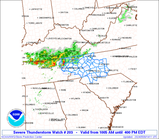
STATUS REPORT ON WW 203

SEVERE WEATHER THREAT CONTINUES RIGHT OF A LINE FROM 30 NE CSV TO
35 NNW HSS.

FOR ADDITIONAL INFORMATION SEE MESOSCALE DISCUSSION 0695.

..GRAMS..05/08/24

ATTN...WFO...GSP...MRX...


STATUS REPORT FOR WS 203

SEVERE WEATHER THREAT CONTINUES FOR THE FOLLOWING AREAS

NCC003-011-021-023-027-035-045-071-087-089-097-099-109-111-115-
119-121-149-161-173-175-199-081640-

NC
.    NORTH CAROLINA COUNTIES INCLUDED ARE

ALEXANDER            AVERY               BUNCOMBE
BURKE                CALDWELL            CATAWBA
CLEVELAND            GASTON              HAYWOOD
HENDERSON            IREDELL             JACKSON
LINCOLN              MCDOWELL            MADISON
MECKLENBURG          MITCHELL            POLK
RUTHERFORD           SWAIN               TRANSYLVANIA
YANCEY


SCC021-045-083-091-081640-

SC
.    SOUTH CAROLINA COUNTIES INCLUDED ARE

CHEROKEE             GREENVILLE          SPARTANBURG
YORK
https://www.spc.noaa.gov/products/watch/ws0203.html
date: 2024-05-08, from: NOAA tornado/severe thunderstorm watches, mesoscale discussions, convective outlooks, fire weather outlooks

Mesoscale Discussion 0695
NWS Storm Prediction Center Norman OK
0956 AM CDT Wed May 08 2024

Areas affected...Eastern TN and western NC

Concerning...Severe Thunderstorm Watch 203...

Valid 081456Z - 081630Z

The severe weather threat for Severe Thunderstorm Watch 203
continues.

SUMMARY...A pair of supercells will pose threats for large hail of
1-1.75 inches in diameter and damaging winds from 55-70 mph as they
likely persist east-southeast across the remainder of eastern
Tennessee and into western North Carolina.

DISCUSSION...A pair of long-lived supercells, the easternmost of
which appears to be the more intense of the two, are steadily
tracking east-southeast across eastern TN. The downstream air mass
continues to destabilize, with surface temperatures having warmed
through the 60s to low 70s over the Great Smoky and Blue Ridge
Mountains, and through the 70s to low 80s across the adjacent
Piedmont. This will support the eastern extension of the TN Valley
buoyancy plume which was characterized by MLCAPE of 2000-2500 J/kg
per the 12Z BNA sounding. While low-level shear will remain weak per
MRX VWP data, strong mid to upper-level westerlies will support
persistence of discrete supercells which may consolidate into a
cluster as they emerge east of the higher terrain in the early
afternoon.

..Grams.. 05/08/2024

...Please see www.spc.noaa.gov for graphic product...

ATTN...WFO...RNK...GSP...MRX...

LAT...LON   36398306 36248183 35908136 35668125 35248147 35138202
            35268304 35508386 35738461 36048458 36398306
https://www.spc.noaa.gov/products/md/md0695.html
date: 2024-05-08, from: NOAA tornado/severe thunderstorm watches, mesoscale discussions, convective outlooks, fire weather outlooks

URGENT - IMMEDIATE BROADCAST REQUESTED
Severe Thunderstorm Watch Number 203
NWS Storm Prediction Center Norman OK
1005 AM EDT Wed May 8 2024

The NWS Storm Prediction Center has issued a

* Severe Thunderstorm Watch for portions of
  Western North Carolina
  Upstate South Carolina
  Eastern Tennessee

* Effective this Wednesday morning and afternoon from 1005 AM
  until 400 PM EDT.

* Primary threats include...
  Scattered damaging wind gusts to 70 mph likely
  Scattered large hail events to 1.5 inches in diameter likely

SUMMARY...Clusters of storms, with both bowing and embedded
supercell characteristics, will likely continue into the afternoon
while spreading east-southeastward across eastern Tennessee into
western North Carolina and the northern part of upstate South
Carolina.  Scattered damaging winds of 60-70 mph and large hail of
1-1.5 inches in diameter can be expected.

The severe thunderstorm watch area is approximately along and 40
statute miles north and south of a line from 40 miles west northwest
of Knoxville TN to 10 miles north of Charlotte NC. For a complete
depiction of the watch see the associated watch outline update
(WOUS64 KWNS WOU3).

PRECAUTIONARY/PREPAREDNESS ACTIONS...

REMEMBER...A Severe Thunderstorm Watch means conditions are
favorable for severe thunderstorms in and close to the watch area.
Persons in these areas should be on the lookout for threatening
weather conditions and listen for later statements and possible
warnings. Severe thunderstorms can and occasionally do produce
tornadoes.

&&

OTHER WATCH INFORMATION...CONTINUE...WW 202...

AVIATION...A few severe thunderstorms with hail surface and aloft to
1.5 inches. Extreme turbulence and surface wind gusts to 60 knots. A
few cumulonimbi with maximum tops to 500. Mean storm motion vector
24035.

...Thompson
https://www.spc.noaa.gov/products/watch/ww0203.html
date: 2024-05-08, from: NOAA tornado/severe thunderstorm watches, mesoscale discussions, convective outlooks, fire weather outlooks
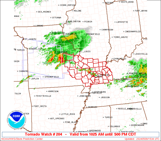
STATUS FOR WATCH 0204 HAS NOT BEEN ISSUED YET
https://www.spc.noaa.gov/products/watch/ws0204.html
date: 2024-05-08, from: NOAA tornado/severe thunderstorm watches, mesoscale discussions, convective outlooks, fire weather outlooks

URGENT - IMMEDIATE BROADCAST REQUESTED
Tornado Watch Number 204
NWS Storm Prediction Center Norman OK
1025 AM CDT Wed May 8 2024

The NWS Storm Prediction Center has issued a

* Tornado Watch for portions of
  Southern Illinois
  Western Kentucky
  Southeastern Missouri

* Effective this Wednesday morning and afternoon from 1025 AM
  until 500 PM CDT.

* Primary threats include...
  A few tornadoes likely with a couple intense tornadoes possible
  Widespread large hail and scattered very large hail events to 3
    inches in diameter likely
  Widespread damaging winds and isolated significant gusts to 80
    mph likely

SUMMARY...A supercell cluster in Missouri will likely persist
through the afternoon while spreading east-southeastward toward
southern Illinois, southeastern Missouri and western Kentucky, with
some potential for additional storm development this afternoon.  The
environment will become more favorable for surface-based storms
capable of producing tornadoes (a couple of which could be
strong/EF2+), severe wind swaths up to 80 mph, and very large hail
of 2-3 inches in diameter.

The tornado watch area is approximately along and 45 statute miles
north and south of a line from 5 miles south of Vichy MO to 40 miles
east of Paducah KY. For a complete depiction of the watch see the
associated watch outline update (WOUS64 KWNS WOU4).

PRECAUTIONARY/PREPAREDNESS ACTIONS...

REMEMBER...A Tornado Watch means conditions are favorable for
tornadoes and severe thunderstorms in and close to the watch
area. Persons in these areas should be on the lookout for
threatening weather conditions and listen for later statements
and possible warnings.

&&

OTHER WATCH INFORMATION...CONTINUE...WW 202...WW 203...

AVIATION...Tornadoes and a few severe thunderstorms with hail
surface and aloft to 3 inches. Extreme turbulence and surface wind
gusts to 70 knots. A few cumulonimbi with maximum tops to 550. Mean
storm motion vector 29030.

...Thompson
https://www.spc.noaa.gov/products/watch/ww0204.html
date: 2024-05-08, from: NOAA tornado/severe thunderstorm watches, mesoscale discussions, convective outlooks, fire weather outlooks

URGENT - IMMEDIATE BROADCAST REQUESTED
Severe Thunderstorm Watch Number 202
NWS Storm Prediction Center Norman OK
650 AM CDT Wed May 8 2024

The NWS Storm Prediction Center has issued a

* Severe Thunderstorm Watch for portions of
  Extreme eastern Kansas
  Western and central Missouri

* Effective this Wednesday morning and afternoon from 650 AM
  until 200 PM CDT.

* Primary threats include...
  Scattered large hail and isolated very large hail events to 3
    inches in diameter likely
  Scattered damaging wind gusts to 70 mph possible

SUMMARY...Initially elevated thunderstorms erupting near the KS/MO
line will pose a threat for large to very large hail through midday
as individual cells move northeastward to eastward.  A portion of
this activity may organize into an eastward- to
southeastward-moving, upscale-growing cluster with increasing
damaging-wind potential.

The severe thunderstorm watch area is approximately along and 75
statute miles north and south of a line from 15 miles west southwest
of Olathe KS to Vichy MO. For a complete depiction of the watch see
the associated watch outline update (WOUS64 KWNS WOU2).

PRECAUTIONARY/PREPAREDNESS ACTIONS...

REMEMBER...A Severe Thunderstorm Watch means conditions are
favorable for severe thunderstorms in and close to the watch area.
Persons in these areas should be on the lookout for threatening
weather conditions and listen for later statements and possible
warnings. Severe thunderstorms can and occasionally do produce
tornadoes.

&&

AVIATION...A few severe thunderstorms with hail surface and aloft to
3 inches. Extreme turbulence and surface wind gusts to 60 knots. A
few cumulonimbi with maximum tops to 550. Mean storm motion vector
27030.

...Edwards
https://www.spc.noaa.gov/products/watch/ww0202.html
date: 2024-05-08, from: NOAA tornado/severe thunderstorm watches, mesoscale discussions, convective outlooks, fire weather outlooks

STATUS REPORT ON WW 202

SEVERE WEATHER THREAT CONTINUES RIGHT OF A LINE FROM 35 NE CNU TO
20 SSE CDJ.

..GRAMS..05/08/24

ATTN...WFO...EAX...SGF...LSX...


STATUS REPORT FOR WS 202

SEVERE WEATHER THREAT CONTINUES FOR THE FOLLOWING AREAS

KSC011-037-081640-

KS
.    KANSAS COUNTIES INCLUDED ARE

BOURBON              CRAWFORD


MOC011-013-015-019-027-029-033-039-051-053-057-059-065-077-083-
085-089-101-105-107-125-131-135-141-151-159-161-167-169-185-195-
215-217-225-229-081640-

MO
.    MISSOURI COUNTIES INCLUDED ARE

BARTON               BATES               BENTON
BOONE                CALLAWAY            CAMDEN
CARROLL              CEDAR               COLE
COOPER               DADE                DALLAS
DENT                 GREENE              HENRY
HICKORY              HOWARD              JOHNSON
LACLEDE              LAFAYETTE           MARIES
MILLER               MONITEAU            MORGAN
OSAGE                PETTIS              PHELPS
POLK                 PULASKI             ST. CLAIR
https://www.spc.noaa.gov/products/watch/ws0202.html
date: 2024-05-07, from: NOAA tornado/severe thunderstorm watches, mesoscale discussions, convective outlooks, fire weather outlooks

STATUS FOR WATCH 0196 HAS NOT BEEN ISSUED YET
https://www.spc.noaa.gov/products/watch/ws0196.html
date: 2024-05-07, from: NOAA tornado/severe thunderstorm watches, mesoscale discussions, convective outlooks, fire weather outlooks

Mesoscale Discussion 0680
NWS Storm Prediction Center Norman OK
0333 PM CDT Tue May 07 2024

Areas affected...southern Lower MI...eastern IN...western OH...far
northern KY

Concerning...Severe potential...Tornado Watch likely

Valid 072033Z - 072200Z

Probability of Watch Issuance...80 percent

SUMMARY...As supercells spread quickly east-northeast from southern
Lower MI and northwest IN, an additional tornado watch/watches will
be needed prior to 22Z. This may also include a combined/separate
watch farther south in eastern IN/western OH ahead of supercells
intensifying over the Wabash Valley.

DISCUSSION...As mentioned in MCD 0679, an increasingly favorable
setup for supercells, a couple of which may be long-tracked, is
underway across northwest IN to the Wabash Valley. The northern
storms may being to outpace the rapid boundary-layer
warming/moistening that is occurring across northeast IN and
northwest OH into southern Lower MI. Nevertheless, the intense
mid-level jet will likely foster sustained supercells even as they
become slightly elevated towards southeast Lower MI. With backed
low-level flow and ample low-level shear (per IWX VWP data), the
tornado threat will remain prominent with any supercells along and
south of the surface warm front. A couple strong tornadoes are
possible.

..Grams/Smith.. 05/07/2024

...Please see www.spc.noaa.gov for graphic product...

ATTN...WFO...CLE...JKL...ILN...DTX...LMK...IWX...GRR...IND...

LAT...LON   42758544 42698458 41898367 41398340 40538329 38478394
            38308491 38688589 41048526 42758544
https://www.spc.noaa.gov/products/md/md0680.html
date: 2024-05-07, from: NOAA tornado/severe thunderstorm watches, mesoscale discussions, convective outlooks, fire weather outlooks

Mesoscale Discussion 0679
NWS Storm Prediction Center Norman OK
0253 PM CDT Tue May 07 2024

Areas affected...eastern IL...IN...and southwest Lower MI

Concerning...Tornado Watch 195...

Valid 071953Z - 072100Z

The severe weather threat for Tornado Watch 195 continues.

SUMMARY...Additional supercells are expected to develop and
intensify from the Lake Michigan vicinity southward towards the
Wabash Valley. Large hail and severe wind gusts will be possible,
with the tornado threat increasing as supercells mature into
Indiana.

DISCUSSION...A pair of supercells have been sustained along the
IL/WI border and earlier across the south part of Chicagoland, both
of which should weaken as they progress across southern Lake
Michigan. Several additional updrafts are gradually maturing farther
south over eastern into southern IL and northwest IN. Richer
boundary-layer moisture and stronger low-level shear across the
Wabash Valley portion of the region, all render increasing concern
for one or two of these storms to become long-track supercells.
Within an environment characterized by STP around 3-4, potential
will exist for a strong tornado. A limiting factor though with
southern extent is the degree of mid-level warmth/dryness south of
the intense jet that is ejecting farther north across northern IL
into southern Lower MI. This also renders uncertainty with how far
south sustained supercell development will occur in the near-term
over the Lower OH Valley.

..Grams.. 05/07/2024

...Please see www.spc.noaa.gov for graphic product...

ATTN...WFO...LMK...IWX...GRR...IND...PAH...LOT...ILX...LSX...

LAT...LON   42318646 42628604 42458555 42098515 41288504 40068631
            38648677 38168743 38428884 38798902 39958849 40768846
            41468802 42318646
https://www.spc.noaa.gov/products/md/md0679.html
date: 2024-05-07, from: NOAA tornado/severe thunderstorm watches, mesoscale discussions, convective outlooks, fire weather outlooks

Mesoscale Discussion 0678
NWS Storm Prediction Center Norman OK
0205 PM CDT Tue May 07 2024

Areas affected...parts of central Texas

Concerning...Severe potential...Watch possible

Valid 071905Z - 072130Z

Probability of Watch Issuance...40 percent

SUMMARY...Isolated storms may develop by late afternoon, with a
conditional threat of very large hail. A small Slight Risk is also
being added to the 20Z convective outlook.

DISCUSSION...Surface analysis shows a stationary front from Dallas
southwestward toward Del Rio, with generally weak wind convergence.
Ample low-level moisture exists south and east of the boundary, with
70s F dewpoints and MLCAPE in excess of 3000 J/kg. Convective
inhibition continues to decrease due to heating, as temperature rise
into the upper 80s to near 90 F.

Visible imagery shows increasing CU fields west of the I-35 corridor
from Austin to San Antonio, particularly along the west edge of a
thicker but eroding cloud deck.

Over the next few hours, isolated severe storms may form over this
small region. Relatively long and straight hodographs along with the
deepening moist boundary layer and very strong instability will
conditionally support very large hail. Splitting cells may occur as
well, with left movers also producing hail.

..Jewell/Smith.. 05/07/2024

...Please see www.spc.noaa.gov for graphic product...

ATTN...WFO...FWD...EWX...SJT...

LAT...LON   30309952 30809874 31109823 31239787 31289741 30949691
            30409700 29559766 29179831 29059965 29230010 29570021
            29889996 30309952
https://www.spc.noaa.gov/products/md/md0678.html
date: 2024-05-07, from: NOAA tornado/severe thunderstorm watches, mesoscale discussions, convective outlooks, fire weather outlooks

URGENT - IMMEDIATE BROADCAST REQUESTED
Tornado Watch Number 196
NWS Storm Prediction Center Norman OK
455 PM EDT Tue May 7 2024

The NWS Storm Prediction Center has issued a

* Tornado Watch for portions of
  Northeast Indiana
  Southern Lower Michigan
  Northwest Ohio
  Lake Erie

* Effective this Tuesday afternoon and evening from 455 PM until
  1100 PM EDT.

* Primary threats include...
  A couple tornadoes possible
  Scattered large hail and isolated very large hail events to 2
    inches in diameter possible
  Scattered damaging wind gusts to 70 mph possible

SUMMARY...Scattered thunderstorms will likely move into the Watch
area through the late afternoon and evening.  The more intense
storms, including the possibility for several supercells, will pose
a risk for large hail, severe gusts, and tornadoes.

The tornado watch area is approximately along and 50 statute miles
east and west of a line from 25 miles north northeast of Lansing MI
to 40 miles southwest of Findlay OH. For a complete depiction of the
watch see the associated watch outline update (WOUS64 KWNS WOU6).

PRECAUTIONARY/PREPAREDNESS ACTIONS...

REMEMBER...A Tornado Watch means conditions are favorable for
tornadoes and severe thunderstorms in and close to the watch
area. Persons in these areas should be on the lookout for
threatening weather conditions and listen for later statements
and possible warnings.

&&

OTHER WATCH INFORMATION...CONTINUE...WW 195...

AVIATION...Tornadoes and a few severe thunderstorms with hail
surface and aloft to 2 inches. Extreme turbulence and surface wind
gusts to 60 knots. A few cumulonimbi with maximum tops to 500. Mean
storm motion vector 24035.

...Smith
https://www.spc.noaa.gov/products/watch/ww0196.html
date: 2024-05-07, from: NOAA tornado/severe thunderstorm watches, mesoscale discussions, convective outlooks, fire weather outlooks

STATUS REPORT ON WW 195

SEVERE WEATHER THREAT CONTINUES RIGHT OF A LINE FROM 35 SSE SPI
TO 10 SW DEC TO 20 NW CMI TO 35 NE BMI TO 10 ENE MMO TO 30 SE RFD
TO 5 S JVL TO 20 WNW JVL.

..BENTLEY..05/07/24

ATTN...WFO...LOT...ILX...IND...IWX...GRR...MKX...


STATUS REPORT FOR WT 195

SEVERE WEATHER THREAT CONTINUES FOR THE FOLLOWING AREAS

ILC019-021-023-025-029-031-033-035-037-039-041-043-045-049-053-
063-075-079-089-091-093-097-101-105-111-113-115-139-147-159-173-
183-197-072140-

IL
.    ILLINOIS COUNTIES INCLUDED ARE

CHAMPAIGN            CHRISTIAN           CLARK
CLAY                 COLES               COOK
CRAWFORD             CUMBERLAND          DE KALB
DE WITT              DOUGLAS             DUPAGE
EDGAR                EFFINGHAM           FORD
GRUNDY               IROQUOIS            JASPER
KANE                 KANKAKEE            KENDALL
LAKE                 LAWRENCE            LIVINGSTON
MCHENRY              MCLEAN              MACON
MOULTRIE             PIATT               RICHLAND
SHELBY               VERMILION           WILL


INC005-007-011-013-015-017-021-023-027-039-045-049-053-055-057-
059-063-067-069-071-073-081-083-085-087-089-091-093-095-097-099-
101-103-105-107-109-111-113-119-121-127-131-133-141-145-149-153-
157-159-165-167-169-171-181-183-072140-
https://www.spc.noaa.gov/products/watch/ws0195.html
date: 2024-05-07, from: NOAA tornado/severe thunderstorm watches, mesoscale discussions, convective outlooks, fire weather outlooks

URGENT - IMMEDIATE BROADCAST REQUESTED
Tornado Watch Number 195
NWS Storm Prediction Center Norman OK
225 PM EDT Tue May 7 2024

The NWS Storm Prediction Center has issued a

* Tornado Watch for portions of
  Central and Northern Illinois
  Central and Northern Indiana
  Southwest Lower Michigan
  Southeast Wisconsin
  Lake Michigan

* Effective this Tuesday afternoon and evening from 225 PM until
  900 PM EDT.

* Primary threats include...
  A few tornadoes likely with a couple intense tornadoes possible
  Scattered large hail and isolated very large hail events to 2.5
    inches in diameter possible
  Scattered damaging wind gusts to 70 mph possible

SUMMARY...Scattered thunderstorms are forecast to continue to
develop and intensify this afternoon into the early evening.  The
environment will continue to destabilize through the mid to late
afternoon across much of the Watch area.  The stronger storms will
likely become supercellular and pose a risk for large to very large
hail, severe gusts, and tornadoes.  A couple of the more intense
supercells may yield the potential for a strong tornado.

The tornado watch area is approximately along and 100 statute miles
east and west of a line from 30 miles east northeast of Racine WI to
60 miles southwest of Bloomington IN. For a complete depiction of
the watch see the associated watch outline update (WOUS64 KWNS
WOU5).

PRECAUTIONARY/PREPAREDNESS ACTIONS...

REMEMBER...A Tornado Watch means conditions are favorable for
tornadoes and severe thunderstorms in and close to the watch
area. Persons in these areas should be on the lookout for
threatening weather conditions and listen for later statements
and possible warnings.

&&

AVIATION...Tornadoes and a few severe thunderstorms with hail
surface and aloft to 2.5 inches. Extreme turbulence and surface wind
gusts to 60 knots. A few cumulonimbi with maximum tops to 500. Mean
storm motion vector 24035.

...Smith
https://www.spc.noaa.gov/products/watch/ww0195.html
date: 2024-05-06, from: NOAA tornado/severe thunderstorm watches, mesoscale discussions, convective outlooks, fire weather outlooks
No watches are valid as of Mon May 6 14:01:02 UTC 2024.
https://www.spc.noaa.gov/products/watch/
date: 2024-05-06, from: NOAA tornado/severe thunderstorm watches, mesoscale discussions, convective outlooks, fire weather outlooks
PUBLIC SEVERE WEATHER OUTLOOK
NWS STORM PREDICTION CENTER NORMAN OK
0824 AM CDT MON MAY 06 2024

...Outbreak of tornadoes and severe thunderstorms expected over
parts of the central and southern Plains this afternoon and
tonight...

* LOCATIONS...
  Much of Oklahoma
  Central and eastern Kansas

* HAZARDS...
  Numerous tornadoes, several intense and long track
  Widespread large hail, some baseball size
  Scattered damaging winds, some hurricane force

* SUMMARY...
  A regional outbreak of severe weather with multiple strong,
  long-tracked tornadoes, as well as very large hail and severe
  thunderstorm gusts, is expected over parts of the south-central
  Plains from this afternoon through evening.

Preparedness actions...

Review your severe weather safety procedures for the possibility
of dangerous weather today. Stay tuned to NOAA Weather Radio,
weather.gov, or other media for watches and warnings. A tornado
watch means that conditions are favorable for tornadoes to form
during the next several hours. If a tornado warning is issued for
your area, move to a place of safety, ideally in a basement or
interior room on the lowest floor of a sturdy building.

&&

..Grams.. 05/06/2024