(date: 2024-05-17 10:40:40)
date: 2024-05-17, from: NOAA tornado/severe thunderstorm watches, mesoscale discussions, convective outlooks, fire weather outlooks

Day 2 Convective Outlook
NWS Storm Prediction Center Norman OK
1230 PM CDT Fri May 17 2024

Valid 181200Z - 191200Z

...THERE IS A SLIGHT RISK OF SEVERE THUNDERSTORMS ACROSS PARTS OF
THE SOUTHEAST INTO THE CAROLINAS...

...SUMMARY...
Isolated to scattered severe thunderstorms appear possible across
portions of the Southeast and Carolinas on Saturday, and parts of
the Upper Midwest. Damaging winds should be the main threat, but
occasional severe hail and a tornado or two may also occur.

...Southeast/Carolinas...
There is still some uncertainty with the placement and intensity of
an MCS that will likely be ongoing at the start of the period
Saturday morning along/near the central Gulf Coast. This convection
will be tied to a mid-level shortwave trough and related 50-70 kt
jet that is forecast to move quickly east-northeastward across the
Southeast and Carolinas through the period. Due to the influence of
prior convection in the Day 1 period, there should be a fairly sharp
gradient of low-level moisture and instability along a convectively
reinforced baroclinic boundary extending from southern AL into GA.

Most guidance suggests the ongoing MCS will continue
east-northeastward over these areas into SC Saturday morning while
posing a threat for mainly severe/damaging winds given the presence
of weak to moderate instability downstream. Modest but sufficient
low-level shear should also be present to support a threat for an
embedded tornado or two. Greater severe wind potential will likely
remain confined along and south of the convectively reinforced
boundary. But, some chance for strong to locally severe
thunderstorms with associated hail and gusty wind threat may also
exist across a broader portion of the Southeast into NC along/south
of a cold front through Saturday afternoon.

...Upper Midwest...
Within broad upper troughing across the northwestern CONUS and
western Canada, a compact shortwave trough should advance
northeastward over the northern Plains and Upper Midwest through the
day. A related surface cold front is forecast to surge eastward
across the Upper Midwest through the period. A narrow corridor of
weak to locally moderate destabilization, with MLCAPE generally
ranging 500-1500 J/kg, should develop through Saturday afternoon
along/ahead of the front from parts of far eastern MN into WI and
the U.P. of MI. A belt of strong mid-level west-southwesterly flow
will accompany the shortwave trough, and contribute to around 30-40
kt of deep-layer shear. Organized thunderstorms should develop by
Saturday afternoon, while posing an isolated threat for both
damaging winds and severe hail while spreading eastward through the
early evening. This activity should eventually weaken through
Saturday evening with the loss of daytime heating.

...Central Plains...
Low-level convergence along the cold front and large-scale ascent
aloft become more limited with southward extent into IA and central
Plains. Some guidance does show convective development across these
regions, including near a surface triple point across KS. However,
the overall severe threat appears too limited/isolated to include a
Marginal Risk at this time.

..Gleason.. 05/17/2024
https://www.spc.noaa.gov/products/outlook/day2otlk_1730.html
date: 2024-05-17, from: Eastern Pacific Basin GIS Data
No tropical cyclones as of Fri, 17 May 2024 17:33:09 GMT
date: 2024-05-17, from: NOAA tornado/severe thunderstorm watches, mesoscale discussions, convective outlooks, fire weather outlooks
No watches are valid as of Fri May 17 17:34:02 UTC 2024.
https://www.spc.noaa.gov/products/watch/
date: 2024-05-17, from: NOAA tornado/severe thunderstorm watches, mesoscale discussions, convective outlooks, fire weather outlooks
No Mesoscale Discussions are in effect as of Fri May 17 17:34:02 UTC 2024.
https://www.spc.noaa.gov/products/md/
date: 2024-05-17, from: Eastern Pacific Basin Tropical Cyclones
000
ABPZ20 KNHC 171732
TWOEP
Tropical
Weather Outlook
NWS National Hurricane Center Miami FL
1100 AM
PDT Fri May 17 2024
For the eastern North Pacific…east of 140
degrees west longitude:
South of the Coast of Southwestern
Mexico:
An elongated area of low pressure located several hundred
miles
offshore of the coast of southwestern Mexico continues to
produce a
small area of showers and thunderstorms. While
environmental
conditions appear only marginally favorable due to
nearby dry air,
some development of this system is possible during
the next day or
so as the low remains nearly stationary. By late
this weekend, the
low is forecast to interact or merge with
another system to its
east, and further development is not
expected.
* Formation chance through 48 hours…low…30 percent.
* Formation chance through 7 days…low…30 percent.
South of
the Coast of Southern Mexico:
Disorganized showers and
thunderstorms located several hundred miles
to the south of
southern Mexico are associated with a trough of low
pressure.
Development of this system, if any, should be slow to
occur as the
disturbance moves slowly westward during the next few
days.
*
Formation chance through 48 hours…low…near 0 percent.
* Formation
chance through 7 days…low…20 percent.
$$
Forecaster
Reinhart
https://www.nhc.noaa.gov/gtwo.php?basin=epac
date: 2024-05-17, from: Eastern Pacific Basin Tropical Cyclones
No tropical cyclones as of Fri, 17 May 2024 17:33:09 GMT
date: 2024-05-17, from: Graphical Tropical Weather Outlooks
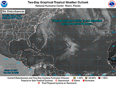
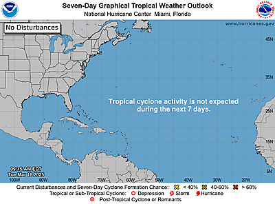
https://www.nhc.noaa.gov/gtwo.php?basin=atlc
date: 2024-05-17, from: NOAA tornado/severe thunderstorm watches, mesoscale discussions, convective outlooks, fire weather outlooks

Day 1 Fire Weather Outlook
NWS Storm Prediction Center Norman OK
1144 AM CDT Fri May 17 2024

Valid 171700Z - 181200Z

...NO CRITICAL AREAS...

The previous forecast is still on track. There is very low potential
for some isolated high-based thunderstorms (given very dry sub-cloud
layers) to overlap more receptive fuels near the Davis Mountains and
lower Trans Pecos of Texas this afternoon as a mid-level shortwave
trough traverses the region. However, the threat appears too
localized to necessitate the need for a DryT highlight.

..Barnes/Weinman.. 05/17/2024

.PREV DISCUSSION... /ISSUED 0121 AM CDT Fri May 17 2024/

...Synopsis...
On Friday, a positively tilted mid-level shortwave trough will
traverse the southeastern United States with another shortwave
trough across the northern Rockies. Some breezy conditions will
accompany the system moving across the Southeast, but very moist
fuels and high relative humidity will mitigate any threat.

Overlap of low relative humidity and moderate/strong winds is
expected across the northern Rockies as a mid-level trough and
surface front move through the region. However, fuels are not dry
enough to sustain large fires at this time.

Therefore, no fire weather areas are warranted for Friday.

...Please see www.spc.noaa.gov/fire for graphic product...
https://www.spc.noaa.gov/products/fire_wx/fwdy1.html
date: 2024-05-17, from: NOAA tornado/severe thunderstorm watches, mesoscale discussions, convective outlooks, fire weather outlooks

Day 1 Convective Outlook
NWS Storm Prediction Center Norman OK
1115 AM CDT Fri May 17 2024

Valid 171630Z - 181200Z

...THERE IS A SLIGHT RISK OF SEVERE THUNDERSTORMS OVER PARTS OF THE
SOUTHEAST...AND PARTS OF THE NORTHERN PLAINS...

...SUMMARY...
Severe thunderstorms may impact parts of the central into eastern
Gulf Coast states and portions of the northern Great Plains this
afternoon through tonight.

...Northern Plains...
Morning satellite imagery shows a fast-moving shortwave trough over
western MT.  This feature will track into the northern High Plains
by mid-afternoon, where strong heating and steep low-level lapse
rates will be present.  Low-level moisture will be limited with
dewpoints only in the mid 40s.  However, cool temperatures aloft and
steep mid-level lapse rates will aid in the development of scattered
showers and thunderstorms over eastern MT - spreading eastward
across the Dakotas during the evening.  High-based and fast-moving
clusters of storms capable of damaging wind gusts appear to be the
main concern.  These storms may move into northwest MN before
weakening.

...Gulf Coast and Southeast States...
Widespread showers and thunderstorms are ongoing this morning from
southern MS into southern AL/GA.  Decreasing cloud cover to the
south of the convection will aid in destabilization, with a general
intensification of thunderstorms by mid-afternoon.  Strong
deep-layer westerly winds aloft and sufficient CAPE will promote
occasional storm intensification with locally damaging wind gusts
being the main threat. Activity may spread as far east as southeast
GA this evening.

...South TX into Southern LA...
Water vapor imagery shows a pronounced southern-stream upper trough
over west TX/northern Mexico.  This feature and an associated
mid-level speed max are expected to aid in the development of
scattered afternoon thunderstorms over the mountains of northern
Mexico, tracking into south TX.  Widespread morning storms over
south TX have greatly stabilized the air mass in this region,
lending uncertainty to how numerous/intense these afternoon storms
may become.  Therefore will maintain MRGL risk and re-evaluate later
today.  Whatever activity evolves across TX will track across the
northwest Gulf and move into southern LA late tonight, with the
potential for damaging wind gusts.

..Hart/Wendt.. 05/17/2024
https://www.spc.noaa.gov/products/outlook/day1otlk_1630.html
date: 2024-05-17, from: NOAA tornado/severe thunderstorm watches, mesoscale discussions, convective outlooks, fire weather outlooks

Day 1 Convective Outlook
NWS Storm Prediction Center Norman OK
0758 AM CDT Fri May 17 2024

Valid 171300Z - 181200Z

...THERE IS A SLIGHT RISK OF SEVERE THUNDERSTORMS OVER PARTS OF THE
SOUTHEAST...AND PARTS OF THE NORTHERN PLAINS...

...SUMMARY...
Severe thunderstorms may impact parts of the central into eastern
Gulf Coast states and portions of the northern Great Plains this
afternoon through tonight.

...Synopsis...
In mid/upper levels, a progressive, split-flow pattern will shift
eastward across the CONUS.  In the northern stream, a complex trough
over western Canada and the U.S Pacific Northwest should evolve
gradually to a closed cyclone over central parts of AB and SK by the
end of the period.  A basal perturbation -- evident in moisture-
channel imagery over WA -- will move eastward to western ND by 12Z
tomorrow.  This feature will be preceded by 9-12 hours along a
similar path, by a weaker (yet still influential) shortwave trough
now over the northern Rockies.  This perturbation should reach
western ND at or shortly before 00Z.

The main pattern split occurs around the northwest side of a
separate shortwave trough -- extending initially from the Mid-South
west-southwestward across the Red River region of southern OK/north
TX, then southwestward over the Big Bend region.  This trough should
shed its northeastern portion, lose some positive tilt, and reach
near a LIT-TXK-ALI line by 12Z.  A strong belt of west-southwesterly
mid/upper winds will extend from the northwestern Gulf and east TX
across much of the Southeast.  This flow field will host numerous
small-scale vorticity maxima (some convectively induced/magnified).

At the surface, 11Z analysis showed a wavy, quasistationary frontal
zone extending from just off the SC coast across central FL, to the
northeastern Gulf, where it has been overtaken by an MCS and
accompanying outflow extending to just off the MS coastline.  The
front was evident again from a weak low near ARA southwestward over
the mid/upper TX coastal waters to between MFE-LRD.  The western
segment of this boundary should move southeastward through the
remainder of deep south TX by mid/late afternoon.  Meanwhile, the
front-reinforcing outflow boundary from the MCS should move
northward to northeastward and inland today, gradually becoming more
diffuse amidst a broad, ambient, low-level theta-e advection regime.

...Southeastern CONUS...
Ongoing convection capable of isolated severe potential includes:
1.  A long-lived MCS/bow echo moving east-southeastward from the
northeastern Gulf/Apalachee Bay region across coastal northwestern
FL, mainly moving over relatively stable surface air along and north
of the front.  This complex may penetrate strong to isolated severe
gusts to the surface the next 1-2 hours before weakening.  See SPC
mesoscale discussion 813 for near-term details.
2.  Isolated to scattered thunderstorms, elevated atop the cold pool
from the northeastern Gulf complex, with potential for isolated
severe hail for a few more hours.

Thunderstorms in the expanding warm sector, and along the front,
should pose a risk for a few tornadoes, along with large hail and
severe gusts, this afternoon into tonight.  The main uncertainty at
this time is coverage, and by which preferred mechanism the greatest
lift will occur (related concepts).  Warm-frontal passage and
diurnal heating will combine to destabilize the airmass inland from
southwest-northeast today, with upper 60s to mid 70s F surface
dewpoints.  This will yield MLCAPE in the 2000-3500 J/kg range,
beneath 45-60 kt effective-shear magnitudes, once surface-based
parcels are attained.  A more-focused area of severe potential may
develop within the lengthy corridor outlooked, particularly near the
inland-shifting baroclinic zone where low-level shear should be
maximized.  However, mesoscale uncertainties are still too large to
introduce greater unconditional severe probabilities at this time.

...Northern Plains...
Scattered, high-based thunderstorms are expected to develop this
afternoon over the Bighorns and perhaps farther northward/
northeastward over the Plains of southeastern MT.  Activity then
should sweep east-northeastward across the northern Great Plains
into the eastern Dakotas and perhaps northwestern MN tonight before
weakening.  Along that swath, one or more clusters of cold-pool-
driven convection are possible, offering severe gusts.

A deep, well-mixed subcloud layer will support locally intense
downdrafts, which may also include downward momentum transfer from
strong midlevel winds, and which should be the most common in and
near the 15%/"slight" probabilities.  Surface dewpoints initially
analyzed in the 40s to low 50s across the region should lower to the
mid/upper 30s and 40s today, as diurnal heating and mixing reduce
boundary-layer moisture content.  Nonetheless, steep low/middle-
level lapse rates will be fostered by the approaching shortwave
perturbation and surface heating.  Meanwhile, remaining moisture
will support surface-based buoyancy across much of the area, with
MLCAPE 200-700 J/kg being common.  At least loosely organized cold
pools should drive this activity across a broad swath of the Dakotas
before weakening tonight over or near the Red River of the North.

...South TX...
Ongoing areas of thunderstorms over south TX in the SAT-CRP-LRD
triangle, and approaching deep south TX from adjoining MX, are
moving generally east-northeastward across this region.  Activity
will be capable of isolated, episodic large hail through midday,
amid favorable deep shear and elevated buoyancy, before shifting
east of the area.

..Edwards/Goss.. 05/17/2024
https://www.spc.noaa.gov/products/outlook/day1otlk_1300.html
date: 2024-05-16, from: NOAA tornado/severe thunderstorm watches, mesoscale discussions, convective outlooks, fire weather outlooks

Mesoscale Discussion 0801
NWS Storm Prediction Center Norman OK
1026 AM CDT Thu May 16 2024

Areas affected...parts of central Texas

Concerning...Severe potential...Watch likely

Valid 161526Z - 161800Z

Probability of Watch Issuance...80 percent

SUMMARY...Storms will likely increase in coverage and intensity over
the next several hours, with damaging wind and areas of hail.

DISCUSSION...Widespread rain and storms currently exist along and
north of an outflow boundary, extending from just south of the MAF
to SJT area and curling into northeastern TX. Surface observations
indicate the outflow continues to push south, resulting in an
undercutting action to the existing convection.

As of 15Z, the most notable area of storms was just northeast of
SJT. This convection may be developing into a small MCS, with
northern portions clearly elevated and additional development
occurring along the southern flank. These storms may continue to
grow upscale, ingesting the very moist and unstable air, and
translating east/southeast along the cold front/outflow.

Additional storms are also developing just southwest of SJT, where
robust moisture has pushed westward beneath slightly cooler
temperatures aloft with less capping.  The deepening boundary layer
should generally reduce CIN through the day, with the end result
increasing coverage of strong to severe storms. Damaging winds will
be the primary threat, although large hail may occur with the more
discrete storms before they merge into an MCS.

..Jewell/Thompson.. 05/16/2024

...Please see www.spc.noaa.gov for graphic product...

ATTN...WFO...FWD...EWX...SJT...

LAT...LON   30139882 30140099 30300133 30610140 30970127 31110115
            31400087 31769972 31879902 32109770 32239695 31949646
            31469627 31069646 30769679 30669697 30469745 30139882
https://www.spc.noaa.gov/products/md/md0801.html
date: 2024-05-16, from: NOAA tornado/severe thunderstorm watches, mesoscale discussions, convective outlooks, fire weather outlooks

STATUS FOR WATCH 0248 HAS NOT BEEN ISSUED YET
https://www.spc.noaa.gov/products/watch/ws0248.html
date: 2024-05-16, from: NOAA tornado/severe thunderstorm watches, mesoscale discussions, convective outlooks, fire weather outlooks

URGENT - IMMEDIATE BROADCAST REQUESTED
Severe Thunderstorm Watch Number 248
NWS Storm Prediction Center Norman OK
1050 AM CDT Thu May 16 2024

The NWS Storm Prediction Center has issued a

* Severe Thunderstorm Watch for portions of
  Central Texas

* Effective this Thursday morning and afternoon from 1050 AM
  until 500 PM CDT.

* Primary threats include...
  Scattered large hail and isolated very large hail events to 2
    inches in diameter likely
  Scattered damaging wind gusts to 70 mph likely
  A tornado or two possible

SUMMARY...Clusters of storms, including both supercells and bowing
segments, are expected to continue to increase in coverage and
intensify into the afternoon, mainly along and south of an outflow
boundary that continues to move southward.  Damaging winds of 60-70
mph will be the most common threat, though any more
discrete/supercell storms could produce large hail of 1-2 inches in
diameter.  An isolated tornado or two could also occur with
favorable storm/boundary interactions.

The severe thunderstorm watch area is approximately along and 55
statute miles north and south of a line from 60 miles north
northwest of Junction TX to 50 miles southeast of Temple TX. For a
complete depiction of the watch see the associated watch outline
update (WOUS64 KWNS WOU8).

PRECAUTIONARY/PREPAREDNESS ACTIONS...

REMEMBER...A Severe Thunderstorm Watch means conditions are
favorable for severe thunderstorms in and close to the watch area.
Persons in these areas should be on the lookout for threatening
weather conditions and listen for later statements and possible
warnings. Severe thunderstorms can and occasionally do produce
tornadoes.

&&

AVIATION...A few severe thunderstorms with hail surface and aloft to
2 inches. Extreme turbulence and surface wind gusts to 60 knots. A
few cumulonimbi with maximum tops to 600. Mean storm motion vector
29030.

...Thompson
https://www.spc.noaa.gov/products/watch/ww0248.html
date: 2024-05-15, from: NOAA tornado/severe thunderstorm watches, mesoscale discussions, convective outlooks, fire weather outlooks

Mesoscale Discussion 0794
NWS Storm Prediction Center Norman OK
0301 PM CDT Wed May 15 2024

Areas affected...Oklahoma Panhandle...Texas Panhandle...and far
eastern New Mexico

Concerning...Severe potential...Watch possible

Valid 152001Z - 152130Z

Probability of Watch Issuance...60 percent

SUMMARY...Watch possible this afternoon as potential for damaging
winds and large hail increases.

DISCUSSION...Visible satellite shows areas of cu developing across
portions of eastern New Mexico into the Texas and Oklahoma
Panhandles. Trends in CAM guidance and morning/afternoon WoFS runs
show medium confidence in storm initiation across the Texas
Panhandle by 20-21z. Temperatures are in the mid to upper 80s with
steep mid-level lapse rates around 8.5-9 C/km. Surface objective
analysis shows MLCAPE around 1000-2000 J/kg from the Texas Panhandle
into western Oklahoma with mid-level capping remaining, though
surface temperatures in the mid 80s should remove the cap per the
19z AMA sounding. High-based convection will initially pose a risk
of severe winds, given deeply mixed profiles and large dew point
depressions. A watch may be needed prior to 21z.

..Thornton/Thompson.. 05/15/2024

...Please see www.spc.noaa.gov for graphic product...

ATTN...WFO...OUN...DDC...LUB...AMA...MAF...PUB...ABQ...

LAT...LON   34960335 35760348 36430323 36900277 37050161 37140048
            36980008 35990000 33509992 33210037 32870142 32850193
            32870249 33320289 34960335
https://www.spc.noaa.gov/products/md/md0794.html
date: 2024-05-15, from: NOAA tornado/severe thunderstorm watches, mesoscale discussions, convective outlooks, fire weather outlooks

Mesoscale Discussion 0793
NWS Storm Prediction Center Norman OK
0224 PM CDT Wed May 15 2024

Areas affected...Portions of southern NC into SC

Concerning...Severe Thunderstorm Watch 245...

Valid 151924Z - 152130Z

The severe weather threat for Severe Thunderstorm Watch 245
continues.

SUMMARY...Scattered damaging winds and severe hail should occur with
thunderstorms moving eastward across parts of southern North
Carolina into South Carolina this afternoon.

DISCUSSION...Multiple thunderstorms have developed this afternoon
along/near a surface front that remains draped across parts of
western/southern NC, near the SC border. Marginally severe hail has
occurred with some of this initially more discrete activity. Recent
tendency has been for some clustering to occur near the boundary in
southern NC. The threat for scattered damaging winds should increase
as these small clusters spread eastward over the next couple of
hours, as low-level lapse rates continue to steepen with diurnal
heating amid low/mid-level westerly winds gradually strengthening
with height. Farther south into SC, a more isolated/cellular mode
amid 35-40 kt of deep-layer shear should support a continued threat
for severe hail, along with occasional strong/damaging winds.

..Gleason.. 05/15/2024

...Please see www.spc.noaa.gov for graphic product...

ATTN...WFO...MHX...RAH...ILM...CHS...CAE...GSP...

LAT...LON   35598204 35818134 35357993 34917754 34117779 33247915
            33508175 34438249 35598204
https://www.spc.noaa.gov/products/md/md0793.html
date: 2024-05-15, from: NOAA tornado/severe thunderstorm watches, mesoscale discussions, convective outlooks, fire weather outlooks

URGENT - IMMEDIATE BROADCAST REQUESTED
Severe Thunderstorm Watch Number 245
NWS Storm Prediction Center Norman OK
110 PM EDT Wed May 15 2024

The NWS Storm Prediction Center has issued a

* Severe Thunderstorm Watch for portions of
  Southern North Carolina
  Northern South Carolina
  Coastal Waters

* Effective this Wednesday afternoon and evening from 110 PM
  until 800 PM EDT.

* Primary threats include...
  Scattered damaging wind gusts to 70 mph possible
  Scattered large hail events to 1.5 inches in diameter possible

SUMMARY...Scattered thunderstorm development is expected this
afternoon along and south of a stalled front across southern North
Carolina, and storms will persist into this evening while moving
eastward to the coast.  The storm environment will support both
supercells with large hail of 1-1.5 inches in diameter and
clusters/bowing segments with 60-70 mph outflow winds.

The severe thunderstorm watch area is approximately along and 65
statute miles north and south of a line from 25 miles north
northwest of Columbia SC to 55 miles east southeast of Wilmington
NC. For a complete depiction of the watch see the associated watch
outline update (WOUS64 KWNS WOU5).

PRECAUTIONARY/PREPAREDNESS ACTIONS...

REMEMBER...A Severe Thunderstorm Watch means conditions are
favorable for severe thunderstorms in and close to the watch area.
Persons in these areas should be on the lookout for threatening
weather conditions and listen for later statements and possible
warnings. Severe thunderstorms can and occasionally do produce
tornadoes.

&&

OTHER WATCH INFORMATION...CONTINUE...WW 244...

AVIATION...A few severe thunderstorms with hail surface and aloft to
1.5 inches. Extreme turbulence and surface wind gusts to 60 knots. A
few cumulonimbi with maximum tops to 500. Mean storm motion vector
27030.

...Thompson
https://www.spc.noaa.gov/products/watch/ww0245.html
date: 2024-05-15, from: NOAA tornado/severe thunderstorm watches, mesoscale discussions, convective outlooks, fire weather outlooks

STATUS REPORT ON WW 245

THE SEVERE WEATHER THREAT CONTINUES ACROSS THE ENTIRE WATCH AREA.

FOR ADDITIONAL INFORMATION SEE MESOSCALE DISCUSSION 0793

..GLEASON..05/15/24

ATTN...WFO...RAH...ILM...GSP...MHX...CAE...


STATUS REPORT FOR WS 245

SEVERE WEATHER THREAT CONTINUES FOR THE FOLLOWING AREAS

NCC007-017-019-025-031-047-049-051-061-071-085-093-103-105-107-
119-123-125-129-133-137-141-153-155-163-165-167-179-152040-

NC
.    NORTH CAROLINA COUNTIES INCLUDED ARE

ANSON                BLADEN              BRUNSWICK
CABARRUS             CARTERET            COLUMBUS
CRAVEN               CUMBERLAND          DUPLIN
GASTON               HARNETT             HOKE
JONES                LEE                 LENOIR
MECKLENBURG          MONTGOMERY          MOORE
NEW HANOVER          ONSLOW              PAMLICO
PENDER               RICHMOND            ROBESON
SAMPSON              SCOTLAND            STANLY
UNION


SCC017-021-023-025-027-031-033-039-041-043-051-055-057-059-061-
063-067-069-071-075-079-083-085-087-089-091-152040-

SC
.    SOUTH CAROLINA COUNTIES INCLUDED ARE
https://www.spc.noaa.gov/products/watch/ws0245.html
date: 2024-05-15, from: NOAA tornado/severe thunderstorm watches, mesoscale discussions, convective outlooks, fire weather outlooks

Day 1 Convective Outlook
NWS Storm Prediction Center Norman OK
0242 PM CDT Wed May 15 2024

Valid 152000Z - 161200Z

...THERE IS AN ENHANCED RISK OF SEVERE THUNDERSTORMS FROM THE TX
PANHANDLE INTO NORTHWEST OK AND SOUTH KS...

...THERE IS A SLIGHT RISK OF SEVERE THUNDERSTORMS IN SC AND SOUTHERN
NC...

...SUMMARY...
Severe thunderstorms are expected across the southern Plains this
afternoon and evening, accompanied by severe wind gusts, large hail,
and perhaps a tornado or two. Scattered severe thunderstorms are
also possible into early evening across parts of the Carolinas.

...20Z Update...
Two appreciable changes were made to the outlook. First, the level
2-SLGT risk across FL has been removed in the wake of the primary
convective clusters having moved off the coast. Isolated
thunderstorms may redevelop this evening into tonight, so the level
1-MRGL risk has been maintained for now. The other adjustment was to
add a small 2 percent tornado area in southwest MN where an arc of
low-topped convection has developed ahead of a shortwave trough and
attendant surface cyclone in SD. A brief tornado remains possible
along the edge of mid 50s surface dew points where temperatures have
warmed into the middle 60s to low 70s. This potential should be
short-lived as the corridor of modest low-level SRH shifts
northeastward away from the meager buoyancy plume emanating north
from the Mid-MO Valley.

..Grams.. 05/15/2024

.PREV DISCUSSION... /ISSUED 1130 AM CDT Wed May 15 2024/

...Carolinas this afternoon/evening...
Along and south of a slow moving front across southern NC, surface
heating in cloud breaks and boundary-layer dewpoints of 65-70 F are
contributing to MLCAPE of 1500-2000 J/kg and minimal convective
inhibition.  Thunderstorm development is expected by early afternoon
along/south of the front into the warm sector, in advance of
embedded perturbations rotating around the southeast periphery of a
midlevel trough approaching the southern Appalachians.  Mostly
straight hodographs with effective bulk shear of 35-50 kt will favor
a mix of organized clusters and/or supercells capable of producing
large hail of 1-1.75 inches in diameter and damaging winds of 60-70
mph.

...Central FL today...
Convection is ongoing along and north of a diffuse outflow boundary
across central FL, as well as upstream over the eastern Gulf of
Mexico.  VWPs from TBW/MLB/JAX show largely unidirectional,
west-southwesterly wind profiles with straight hodographs, in an
environment with MLCAPE of 2000-3000 J/kg.  Central FL will be along
the southern periphery of the southern Appalachians midlevel trough
with modest forcing for ascent near its peak this afternoon.  It
appears the strongest storms, which will include a mix of
supercells/clusters, will tend to remain along the southern fringe
of the ongoing convection, with more uncertainty farther north based
on more extensive cloud cover.  The strongest storms will be capable
of producing large hail up to 1.5 inches in diameter and 60-70 mph
outflow winds.

...Southern Plains this afternoon into tonight...
A shallow, moist boundary layer is returning to south TX, but areas
farther to the north will rely on residual low-level moisture and
evapotranspiration from moist soil and green vegetation to boost
boundary-layer dewpoints into the 50s/low 60s.  Weak perturbations
will move eastward from northern NM and CO toward the TX
Panhandle/northwest OK/KS, along a weak front from central KS to the
TX Panhandle.  Strong surface heating along and south of the front
will drive a deepening mixed layer, while there will be sufficient
moisture/steep midlevel lapse rates to support MLCAPE of 1000-2000
J/kg.  The moderate buoyancy and inverted-V profiles will favor
hybrid microbursts with severe outflow winds of 60-80 mph,
especially with any organized clusters/high-based supercells and
storm mergers.  Large hail of 1-2 inches in diameter will be
possible with any persistent supercells or favorable storm mergers.
The tornado threat will be tempered by modest low-level moisture.
https://www.spc.noaa.gov/products/outlook/day1otlk_2000.html
date: 2024-05-15, from: NOAA tornado/severe thunderstorm watches, mesoscale discussions, convective outlooks, fire weather outlooks

STATUS REPORT ON WW 244

SEVERE WEATHER THREAT CONTINUES RIGHT OF A LINE FROM 35 SSE VRB
TO 20 N DAB TO 30 NE DAB.

..GLEASON..05/15/24

ATTN...WFO...JAX...MLB...TBW...


STATUS REPORT FOR WS 244

SEVERE WEATHER THREAT CONTINUES FOR THE FOLLOWING AREAS

AMZ550-552-555-152040-

CW

.    ADJACENT COASTAL WATERS INCLUDED ARE

THE WATCH STATUS MESSAGE IS FOR GUIDANCE PURPOSES ONLY.  PLEASE
REFER TO WATCH COUNTY NOTIFICATION STATEMENTS FOR OFFICIAL
INFORMATION ON COUNTIES...INDEPENDENT CITIES AND MARINE ZONES
CLEARED FROM SEVERE THUNDERSTORM AND TORNADO WATCHES.
https://www.spc.noaa.gov/products/watch/ws0244.html
date: 2024-05-15, from: NOAA tornado/severe thunderstorm watches, mesoscale discussions, convective outlooks, fire weather outlooks
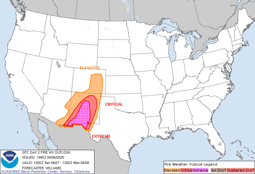
Day 2 Fire Weather Outlook
NWS Storm Prediction Center Norman OK
0228 PM CDT Wed May 15 2024

Valid 161200Z - 171200Z

...2000Z Update...
A few minor changes were made to the Day2 outlook to extend the
Elevated area through the Big Bend and lower Trans Pecos regions.
Westerly downslope flow is expected to increase tomorrow ahead of a
cold front west of the Pecos River valley. Locally sustained wind
speeds will approach or briefly exceed critical limits in and around
the Davis Mountains and Big Bend. A small critical area was
considered for these regions given deeply mixed forecast soundings.
However, relatively weak flow aloft (850-700 mb) and mid to upper
ascent accompanying a shortwave trough during the first half of the
day will preclude the addition of such for the time being.

..Barnes/Lyons.. 05/15/2024

.PREV DISCUSSION... /ISSUED 0150 AM CDT Wed May 15 2024/

...Synopsis...
A mid-level trough will traverse the southern Plains tomorrow
(Thursday), encouraging a surface low to form over western TX, which
will shift northeastward during the day. Strong northwesterly
downslope flow behind the low will overspread the Trans Pecos region
of western Texas during the afternoon. Guidance consensus shows
15-20 mph sustained northwesterly surface winds overlapping 10-20
percent for several hours, necessitating the introduction of
Elevated highlights given the presence of dry fuels.

...Please see www.spc.noaa.gov/fire for graphic product...
https://www.spc.noaa.gov/products/fire_wx/fwdy2.html
date: 2024-05-15, from: NOAA tornado/severe thunderstorm watches, mesoscale discussions, convective outlooks, fire weather outlooks

URGENT - IMMEDIATE BROADCAST REQUESTED
Severe Thunderstorm Watch Number 244
NWS Storm Prediction Center Norman OK
1050 AM EDT Wed May 15 2024

The NWS Storm Prediction Center has issued a

* Severe Thunderstorm Watch for portions of
  Northern/central Florida Peninsula
  Coastal Waters

* Effective this Wednesday morning and afternoon from 1050 AM
  until 500 PM EDT.

* Primary threats include...
  Scattered damaging wind gusts to 70 mph possible
  Scattered large hail events to 1.5 inches in diameter possible
  A tornado or two possible

SUMMARY...Thunderstorms will spread eastward across parts of the
northern/central FL Peninsula through this afternoon, while posing a
threat for mainly large hail and damaging winds.

The severe thunderstorm watch area is approximately along and 60
statute miles east and west of a line from 15 miles east of
Gainesville FL to 30 miles south of Avon Park FL. For a complete
depiction of the watch see the associated watch outline update
(WOUS64 KWNS WOU4).

PRECAUTIONARY/PREPAREDNESS ACTIONS...

REMEMBER...A Severe Thunderstorm Watch means conditions are
favorable for severe thunderstorms in and close to the watch area.
Persons in these areas should be on the lookout for threatening
weather conditions and listen for later statements and possible
warnings. Severe thunderstorms can and occasionally do produce
tornadoes.

&&

OTHER WATCH INFORMATION...This severe thunderstorm watch replaces
tornado watch number 243. Watch number 243 will not be in effect
after 1050 AM EDT.

AVIATION...A few severe thunderstorms with hail surface and aloft to
1.5 inches. Extreme turbulence and surface wind gusts to 60 knots. A
few cumulonimbi with maximum tops to 500. Mean storm motion vector
26035.

...Gleason
https://www.spc.noaa.gov/products/watch/ww0244.html
date: 2024-05-15, from: NOAA tornado/severe thunderstorm watches, mesoscale discussions, convective outlooks, fire weather outlooks

STATUS REPORT ON WW 243

THE SEVERE WEATHER THREAT CONTINUES ACROSS THE ENTIRE WATCH AREA.

FOR ADDITIONAL INFORMATION SEE MESOSCALE DISCUSSION 0790

..GLEASON..05/15/24

ATTN...WFO...MLB...TBW...JAX...


STATUS REPORT FOR WT 243

SEVERE WEATHER THREAT CONTINUES FOR THE FOLLOWING AREAS

FLC009-017-035-053-057-069-075-081-083-095-097-101-103-105-107-
109-117-119-127-151440-

FL
.    FLORIDA COUNTIES INCLUDED ARE

BREVARD              CITRUS              FLAGLER
HERNANDO             HILLSBOROUGH        LAKE
LEVY                 MANATEE             MARION
ORANGE               OSCEOLA             PASCO
PINELLAS             POLK                PUTNAM
ST. JOHNS            SEMINOLE            SUMTER
VOLUSIA


AMZ452-454-550-552-GMZ830-850-853-151440-

CW

.    ADJACENT COASTAL WATERS INCLUDED ARE

COASTAL WATERS FROM FERNANDINA BEACH TO ST. AUGUSTINE FL OUT 20
NM
https://www.spc.noaa.gov/products/watch/ws0243.html
date: 2024-05-14, from: NOAA tornado/severe thunderstorm watches, mesoscale discussions, convective outlooks, fire weather outlooks
URGENT - IMMEDIATE BROADCAST REQUESTED
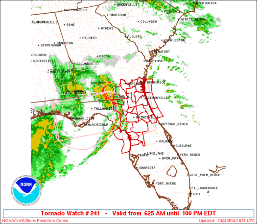
Tornado Watch Number 241
NWS Storm Prediction Center Norman OK
625 AM EDT Tue May 14 2024

The NWS Storm Prediction Center has issued a

* Tornado Watch for portions of
  Northern and Central Florida
  Southeast Georgia
  Coastal Waters

* Effective this Tuesday morning and afternoon from 625 AM until
  100 PM EDT.

* Primary threats include...
  A couple tornadoes possible
  Scattered damaging wind gusts to 70 mph possible

SUMMARY...Storms expected to further develop and intensity across
the region as they generally spread east-northeastward through the
morning, with damaging wind potential and a tornado risk.

The tornado watch area is approximately along and 85 statute miles
north and south of a line from 50 miles west northwest of
Gainesville FL to 15 miles north northeast of St Augustine FL. For a
complete depiction of the watch see the associated watch outline
update (WOUS64 KWNS WOU1).

PRECAUTIONARY/PREPAREDNESS ACTIONS...

REMEMBER...A Tornado Watch means conditions are favorable for
tornadoes and severe thunderstorms in and close to the watch
area. Persons in these areas should be on the lookout for
threatening weather conditions and listen for later statements
and possible warnings.

&&

OTHER WATCH INFORMATION...CONTINUE...WW 240...

AVIATION...Tornadoes and a few severe thunderstorms with hail
surface and aloft to 1 inch. Extreme turbulence and surface wind
gusts to 60 knots. A few cumulonimbi with maximum tops to 500. Mean
storm motion vector 25030.

...Guyer
https://www.spc.noaa.gov/products/watch/ww0241.html
date: 2024-05-14, from: NOAA tornado/severe thunderstorm watches, mesoscale discussions, convective outlooks, fire weather outlooks

STATUS REPORT ON WW 241

SEVERE WEATHER THREAT CONTINUES RIGHT OF A LINE FROM 40 SSW CTY
TO 20 W OCF TO 20 SSE GNV TO 30 SSW SGJ TO 20 NE SGJ.

..GLEASON..05/14/24

ATTN...WFO...JAX...TBW...


STATUS REPORT FOR WT 241

SEVERE WEATHER THREAT CONTINUES FOR THE FOLLOWING AREAS

FLC017-035-053-083-109-119-141540-

FL
.    FLORIDA COUNTIES INCLUDED ARE

CITRUS               FLAGLER             HERNANDO
MARION               ST. JOHNS           SUMTER


AMZ454-GMZ850-141540-

CW

.    ADJACENT COASTAL WATERS INCLUDED ARE

COASTAL WATERS FROM ST. AUGUSTINE TO FLAGLER BEACH FL OUT 20 NM

COASTAL WATERS FROM TARPON SPRINGS TO SUWANNEE RIVER FL OUT 20 NM

THE WATCH STATUS MESSAGE IS FOR GUIDANCE PURPOSES ONLY.  PLEASE
REFER TO WATCH COUNTY NOTIFICATION STATEMENTS FOR OFFICIAL
INFORMATION ON COUNTIES...INDEPENDENT CITIES AND MARINE ZONES
CLEARED FROM SEVERE THUNDERSTORM AND TORNADO WATCHES.
https://www.spc.noaa.gov/products/watch/ws0241.html
date: 2024-05-14, from: NOAA tornado/severe thunderstorm watches, mesoscale discussions, convective outlooks, fire weather outlooks

Mesoscale Discussion 0781
NWS Storm Prediction Center Norman OK
0930 AM CDT Tue May 14 2024

Areas affected...Portions of the northern/central FL Peninsula

Concerning...Severe potential...Watch possible

Valid 141430Z - 141630Z

Probability of Watch Issuance...40 percent

SUMMARY...A cluster of thunderstorms should approach the Tampa metro
and vicinity around 15-16Z (11 AM - Noon EDT), while posing a threat
for mainly damaging winds. New watch issuance is possible to address
this potential.

DISCUSSION...A loosely organized cluster of convection is ongoing
this morning over the eastern Gulf of Mexico. Recent forward motion
of this activity suggests it should approach the FL Gulf Coast by
15-16Z. The 12Z sounding from TBW shows relatively cool mid-level
temperatures for FL (-10 C at 500 mb), along with steepened lapse
rates associated with an EML above 700 mb. But, there is still a
residual cap noted between 800-700 mb, which may tend to limit
updraft intensity over land in the short term. Recent surface
observations and visible satellite imagery also show strong
thunderstorms have developed along trailing outflow from earlier
convection across the north-central FL Peninsula. As robust daytime
heating of a very moist low-level airmass continues along/south of
this boundary, lingering MLCIN should gradually erode. Around
2000-3000 J/kg of MLCAPE will conditionally support intense
updrafts, with sufficiently strong mid-level westerly flow and
related deep-layer shear also fostering organized convection.

Thunderstorm evolution through the afternoon remains somewhat
unclear, as recent IR satellite trends show warming cloud tops with
the eastern Gulf convection. There is still some chance that strong
to severe thunderstorms consolidate along the outflow boundary over
the next couple of hours, and continue spreading eastward across the
central FL Peninsula this afternoon. If this scenario materializes,
then scattered damaging winds around 50-70 mph would likely be the
main threat as low-level lapse rates continue to steepen. A brief
tornado or two may also occur, although low-level flow has had a
tendency to veer to southwesterly this morning per latest VWPs from
KTBW, which has reduced 0-1 km SRH. Marginally severe hail also
appears possible with the more robust updrafts. It remains unclear
whether a new watch will be needed, but observational trends will be
closely monitored.

..Gleason/Thompson.. 05/14/2024

...Please see www.spc.noaa.gov for graphic product...

ATTN...WFO...MLB...TBW...JAX...

LAT...LON   28838244 29328173 29398092 27968019 27428130 27288265
            27768309 28428309 28838244
https://www.spc.noaa.gov/products/md/md0781.html
date: 2024-05-14, from: NOAA tornado/severe thunderstorm watches, mesoscale discussions, convective outlooks, fire weather outlooks
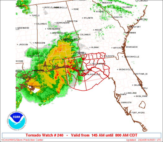
STATUS REPORT ON WW 240

SEVERE WEATHER THREAT CONTINUES RIGHT OF A LINE FROM 85 SW CTY TO
40 NNE CTY TO 15 E VLD TO 25 NE MGR.

FOR ADDITIONAL INFORMATION SEE MESOSCALE DISCUSSION 0778

..DEAN..05/14/24

ATTN...WFO...TAE...


STATUS REPORT FOR WT 240

SEVERE WEATHER THREAT CONTINUES FOR THE FOLLOWING AREAS

FLC029-067-141240-

FL
.    FLORIDA COUNTIES INCLUDED ARE

DIXIE                LAFAYETTE


GAC027-185-141240-

GA
.    GEORGIA COUNTIES INCLUDED ARE

BROOKS               LOWNDES


THE WATCH STATUS MESSAGE IS FOR GUIDANCE PURPOSES ONLY.  PLEASE
REFER TO WATCH COUNTY NOTIFICATION STATEMENTS FOR OFFICIAL
INFORMATION ON COUNTIES...INDEPENDENT CITIES AND MARINE ZONES
CLEARED FROM SEVERE THUNDERSTORM AND TORNADO WATCHES.
https://www.spc.noaa.gov/products/watch/ws0240.html
date: 2024-05-13, from: NOAA tornado/severe thunderstorm watches, mesoscale discussions, convective outlooks, fire weather outlooks
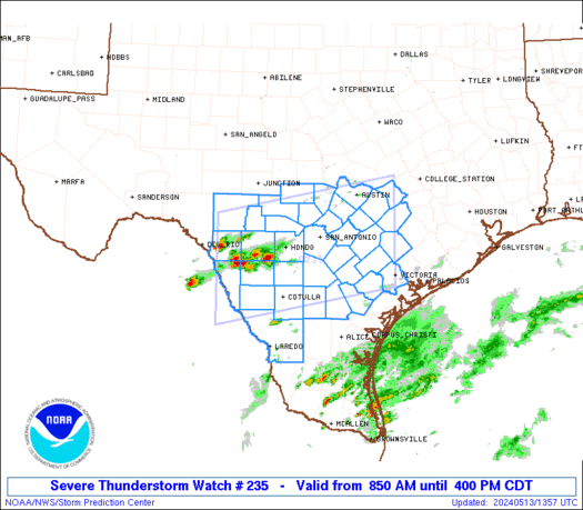
STATUS REPORT ON WW 235

THE SEVERE WEATHER THREAT CONTINUES ACROSS THE ENTIRE WATCH AREA.

..GLEASON..05/13/24

ATTN...WFO...EWX...CRP...


STATUS REPORT FOR WS 235

SEVERE WEATHER THREAT CONTINUES FOR THE FOLLOWING AREAS

TXC013-019-021-025-029-031-055-091-123-127-137-149-163-171-175-
177-187-209-255-259-265-271-283-285-287-297-311-323-325-385-453-
463-469-479-493-507-131540-

TX
.    TEXAS COUNTIES INCLUDED ARE

ATASCOSA             BANDERA             BASTROP
BEE                  BEXAR               BLANCO
CALDWELL             COMAL               DEWITT
DIMMIT               EDWARDS             FAYETTE
FRIO                 GILLESPIE           GOLIAD
GONZALES             GUADALUPE           HAYS
KARNES               KENDALL             KERR
KINNEY               LA SALLE            LAVACA
LEE                  LIVE OAK            MCMULLEN
MAVERICK             MEDINA              REAL
TRAVIS               UVALDE              VICTORIA
WEBB                 WILSON              ZAVALA


THE WATCH STATUS MESSAGE IS FOR GUIDANCE PURPOSES ONLY.  PLEASE
REFER TO WATCH COUNTY NOTIFICATION STATEMENTS FOR OFFICIAL
INFORMATION ON COUNTIES...INDEPENDENT CITIES AND MARINE ZONES
CLEARED FROM SEVERE THUNDERSTORM AND TORNADO WATCHES.
https://www.spc.noaa.gov/products/watch/ws0235.html
date: 2024-05-13, from: NOAA tornado/severe thunderstorm watches, mesoscale discussions, convective outlooks, fire weather outlooks

Mesoscale Discussion 0764
NWS Storm Prediction Center Norman OK
0900 AM CDT Mon May 13 2024

Areas affected...Portions of coastal MS/AL into the western FL
Panhandle

Concerning...Severe Thunderstorm Watch 234...

Valid 131400Z - 131530Z

The severe weather threat for Severe Thunderstorm Watch 234
continues.

SUMMARY...A greater threat for severe/damaging winds should focus
along the Mississippi/Alabama Coast into the western Florida
Panhandle this morning.

DISCUSSION...A small bowing cluster is ongoing over southern/coastal
AL this morning. A warm front is draped east-southeastward across
southern AL into the western FL Panhandle based on latest surface
observations. Recent velocity data from KMOB show strong inbound
velocities at low levels. A greater threat for severe/damaging winds
should be focused along and south of the warm front into parts of
the western FL Panhandle, where there will be a better likelihood
for downdraft winds to reach the surface. Enhanced low-level flow
and strong boundary-layer shear noted on recent VWPs from KMOB may
also support some threat for an embedded tornado.

..Gleason.. 05/13/2024

...Please see www.spc.noaa.gov for graphic product...

ATTN...WFO...TAE...MOB...LIX...

LAT...LON   30808891 31018846 31308785 30998676 30768626 30398604
            30188628 30248711 30118797 30228860 30378884 30808891
https://www.spc.noaa.gov/products/md/md0764.html
date: 2024-05-13, from: NOAA tornado/severe thunderstorm watches, mesoscale discussions, convective outlooks, fire weather outlooks

Mesoscale Discussion 0763
NWS Storm Prediction Center Norman OK
0833 AM CDT Mon May 13 2024

Areas affected...Portions of south-central TX

Concerning...Severe potential...Severe Thunderstorm Watch likely

Valid 131333Z - 131530Z

Probability of Watch Issuance...80 percent

SUMMARY...The threat for very large hail and damaging winds should
continue to increase this morning. Watch issuance is likely.

DISCUSSION...The 12Z sounding from DRT shows rich low-level moisture
beneath steep mid-level lapse rates, with resulting MUCAPE
approaching 4000 J/kg. Strong deep-layer shear of 50-60 kt will
easily support supercell structures, and multiple thunderstorms have
already developed near Eagle Pass TX with a weak mid-level
perturbation ejecting from northern Mexico across TX. Current
expectations are for this ongoing activity to gradually spread
eastward across south-central TX this morning, while posing a threat
for very large hail (around 2-3 inches in diameter) with any
sustained supercells. Occasional severe/damaging downdraft winds may
also occur as low-level lapse rates gradually steepen with filtered
daytime heating. Severe Thunderstorm Watch issuance will likely be
needed to address the increasing threat for very large hail this
morning.

..Gleason/Thompson.. 05/13/2024

...Please see www.spc.noaa.gov for graphic product...

ATTN...WFO...CRP...EWX...

LAT...LON   29300086 29780014 29999847 29919717 29199689 28559715
            28289844 28210009 28390044 28840081 29300086
https://www.spc.noaa.gov/products/md/md0763.html
date: 2024-05-13, from: NOAA tornado/severe thunderstorm watches, mesoscale discussions, convective outlooks, fire weather outlooks

STATUS REPORT ON WW 234

SEVERE WEATHER THREAT CONTINUES RIGHT OF A LINE FROM 25 NW GPT TO
20 ENE MOB TO 25 WSW GZH TO 30 SSE SEM.

FOR ADDITIONAL INFORMATION SEE MESOSCALE DISCUSSION 0764

..GLEASON..05/13/24

ATTN...WFO...MOB...TAE...LIX...


STATUS REPORT FOR WS 234

SEVERE WEATHER THREAT CONTINUES FOR THE FOLLOWING AREAS

ALC003-013-031-035-039-041-045-053-061-069-097-131540-

AL
.    ALABAMA COUNTIES INCLUDED ARE

BALDWIN              BUTLER              COFFEE
CONECUH              COVINGTON           CRENSHAW
DALE                 ESCAMBIA            GENEVA
HOUSTON              MOBILE


FLC005-013-033-045-059-063-091-113-131-133-131540-

FL
.    FLORIDA COUNTIES INCLUDED ARE

BAY                  CALHOUN             ESCAMBIA
GULF                 HOLMES              JACKSON
OKALOOSA             SANTA ROSA          WALTON
WASHINGTON


MSC047-059-131540-
https://www.spc.noaa.gov/products/watch/ws0234.html
date: 2024-05-13, from: NOAA tornado/severe thunderstorm watches, mesoscale discussions, convective outlooks, fire weather outlooks

URGENT - IMMEDIATE BROADCAST REQUESTED
Severe Thunderstorm Watch Number 234
NWS Storm Prediction Center Norman OK
500 AM CDT Mon May 13 2024

The NWS Storm Prediction Center has issued a

* Severe Thunderstorm Watch for portions of
  Southern Alabama
  Florida Panhandle
  Far Southern Mississippi
  Coastal Waters

* Effective this Monday morning from 500 AM until 1100 AM CDT.

* Primary threats include...
  Scattered damaging winds and isolated significant gusts to 75
    mph possible
  Isolated large hail events to 1.5 inches in diameter possible
  A tornado or two possible

SUMMARY...Clusters of east/southeastward-moving storms will likely
intensify this morning along and north of a northward-shifting warm
front.

The severe thunderstorm watch area is approximately along and 55
statute miles north and south of a line from 55 miles northwest of
Mobile AL to 20 miles southeast of Marianna FL. For a complete
depiction of the watch see the associated watch outline update
(WOUS64 KWNS WOU4).

PRECAUTIONARY/PREPAREDNESS ACTIONS...

REMEMBER...A Severe Thunderstorm Watch means conditions are
favorable for severe thunderstorms in and close to the watch area.
Persons in these areas should be on the lookout for threatening
weather conditions and listen for later statements and possible
warnings. Severe thunderstorms can and occasionally do produce
tornadoes.

&&

AVIATION...A few severe thunderstorms with hail surface and aloft to
1.5 inches. Extreme turbulence and surface wind gusts to 65 knots. A
few cumulonimbi with maximum tops to 500. Mean storm motion vector
28040.

...Guyer
https://www.spc.noaa.gov/products/watch/ww0234.html
date: 2024-05-13, from: NOAA tornado/severe thunderstorm watches, mesoscale discussions, convective outlooks, fire weather outlooks

URGENT - IMMEDIATE BROADCAST REQUESTED
Severe Thunderstorm Watch Number 235
NWS Storm Prediction Center Norman OK
850 AM CDT Mon May 13 2024

The NWS Storm Prediction Center has issued a

* Severe Thunderstorm Watch for portions of
  South central Texas

* Effective this Monday morning and afternoon from 850 AM until
  400 PM CDT.

* Primary threats include...
  Widespread large hail and isolated very large hail events to 3
    inches in diameter likely
  Scattered damaging wind gusts to 70 mph likely

SUMMARY...Scattered supercell development is expected this morning
and the storms will likely persist into this afternoon while
spreading eastward and increasing in coverage.  Very large hail up
to 3 inches in diameter and severe outflow gusts of 60-70 mph will
be the primary hazards.

The severe thunderstorm watch area is approximately along and 70
statute miles north and south of a line from 90 miles west northwest
of Cotulla TX to 55 miles north of Victoria TX. For a complete
depiction of the watch see the associated watch outline update
(WOUS64 KWNS WOU5).

PRECAUTIONARY/PREPAREDNESS ACTIONS...

REMEMBER...A Severe Thunderstorm Watch means conditions are
favorable for severe thunderstorms in and close to the watch area.
Persons in these areas should be on the lookout for threatening
weather conditions and listen for later statements and possible
warnings. Severe thunderstorms can and occasionally do produce
tornadoes.

&&

OTHER WATCH INFORMATION...CONTINUE...WW 234...

AVIATION...A few severe thunderstorms with hail surface and aloft to
3 inches. Extreme turbulence and surface wind gusts to 60 knots. A
few cumulonimbi with maximum tops to 600. Mean storm motion vector
27025.

...Thompson