(date: 2024-05-22 09:32:10)
date: 2024-05-22, from: NOAA tornado/severe thunderstorm watches, mesoscale discussions, convective outlooks, fire weather outlooks

Mesoscale Discussion 0889
NWS Storm Prediction Center Norman OK
0949 AM CDT Wed May 22 2024

Areas affected...Southeast OK...Western AR

Concerning...Severe potential...Watch likely

Valid 221449Z - 221645Z

Probability of Watch Issuance...95 percent

SUMMARY...Severe thunderstorm risk is expected to continue for the
next several hour from northwest Arkansas into south-central and
southeast Oklahoma. Hail up to 2.5" in diameter is the primary risk,
with damaging gusts and a tornado or two also possible.

DISCUSSION...Regional radar imagery shows a three well-developed
supercells along a cold front extending southwestward from northwest
AR through south-central OK. Each of one of these supercells has
shown an intensifying trend over the past hour. The northernmost and
southernmost cells both appear to be behind the boundary, although
the southernmost cell has recently shown a eastward surge that might
indicate a trend towards a more surface-based character. This
eastward surge was already noted in the central supercell moving
into Haskell, Latimer, and Pittsburg Counties. Given the organized
character of these storms, anticipated downstream destabilization,
and persistent strong deep-layer vertical shear, the severe threat
with these storms will likely continue through the remainder of the
morning into the early afternoon. Primary severe risk is expected to
be large to very large hail up to 2.5" in diameter. Damaging gusts
are also possible, particularly if the storms trend towards a linear
mode. Given the presence of supercells, a tornado or two is also
possible.

..Mosier/Hart.. 05/22/2024

...Please see www.spc.noaa.gov for graphic product...

ATTN...WFO...LZK...SHV...TSA...OUN...

LAT...LON   34489693 35479472 36189316 35989207 34939237 33969310
            33779390 33939546 34039686 34489693
https://www.spc.noaa.gov/products/md/md0889.html
date: 2024-05-22, from: NOAA tornado/severe thunderstorm watches, mesoscale discussions, convective outlooks, fire weather outlooks

Mesoscale Discussion 0890
NWS Storm Prediction Center Norman OK
1126 AM CDT Wed May 22 2024

Areas affected...Northeast AR...Western and Middle TN...Northwest
MS... Far Southwest KY

Concerning...Severe potential...Watch likely

Valid 221626Z - 221830Z

Probability of Watch Issuance...80 percent

SUMMARY...Increasing thunderstorm coverage is anticipated from
northeast Arkansas into western and middle Tennessee, northwest
Mississippi, and far southwest Kentucky this afternoon. Large hail
and strong gusts are possible, and a watch will likely be needed
soon.

DISCUSSION...Recent radar imagery has shown and increase in deeper
convection across northeast AR, along and ahead of a
southeastward-progressing cold front. Airmass preceding this front
continues to destabilize, with recent surface observations sampling
temperatures in the low 80s and dewpoints in the upper 60s/low 70s.
This warm and moist low-level environment is helping to support
strong buoyancy, despite relatively warm mid-levels and associated
poor lapse rates. Recent mesoanalysis estimates MLCAPE is ranges
from around 2500 J/kg across northeast AR to around 1000 J/kg over
middle TN. Deep layer vertical shear over much of this region is
currently modest, with mesoanalysis estimating effective bulk shear
around 30 to 40 kt. Both buoyancy and vertical shear are forecast to
increase throughout the afternoon, with the increase in buoyancy
driven by continued heating and the increase in shear supported by
increasing mid-level flow.

General expectation is for the currently shallow convection ahead of
the front to deepen over time, with thunderstorm development likely.
Increasing deep layer shear should promote an organized storm mode,
with supercells possible. Large hail up to 1.75" to 2" in diameter
will likely be the primary risk with initial, more cellular storms.
The ongoing activity over northwest AR is expected to continue
eastward, with some interaction between this activity and the more
cellular, pre-frontal development is anticipated. This interaction,
coupled with the steady southeastward progression of the cold front,
will likely promote the transition to a more linear mode. Given the
strengthening westerly flow aloft and ample low-level moisture, the
development of a forward-propagating MCS is possible. Damaging gusts
would be the primary risk with any linear development.

Given all of these factors, a watch will likely be needed soon to
cover the severe potential.

..Mosier/Hart.. 05/22/2024

...Please see www.spc.noaa.gov for graphic product...

ATTN...WFO...OHX...PAH...MEG...LZK...

LAT...LON   35109187 36548997 36878848 36278737 34918840 34178997
            34219091 35109187
https://www.spc.noaa.gov/products/md/md0890.html
date: 2024-05-22, from: NOAA tornado/severe thunderstorm watches, mesoscale discussions, convective outlooks, fire weather outlooks

Day 1 Convective Outlook
NWS Storm Prediction Center Norman OK
1109 AM CDT Wed May 22 2024

Valid 221630Z - 231200Z

...THERE IS AN ENHANCED RISK OF SEVERE THUNDERSTORMS THIS AFTERNOON
AND EVENING FROM CENTRAL TEXAS INTO SOUTHERN ARKANSAS AND NORTHWEST
LOUISIANA...

...SUMMARY...
Within a long swath of severe-thunderstorm potential from central
Texas to the Lower Great Lakes, the greatest concentration of severe
weather (mainly large hail and damaging wind) should be across parts
of central Texas to central Arkansas.  A few tornadoes are also
possible.

...Southeast OK/AR/TN...
A band of strong/severe thunderstorms currently extends from
southeast OK into northwest AR, ahead of a surface cold front.
These storms will track eastward today across AR, with new storms
forming in the moist and moderately unstable air mass farther east.
Activity will spread into west/middle TN this afternoon, with a
continued risk of hail and damaging wind gusts.

...Central/East TX...
The ongoing forecast remains valid, with few changes made this
update cycle.  A very moist surface air mass is present today over
central TX, with widespread dewpoints in the 70s.  Multiple subtle
southern-stream shortwave troughs may affect this region this
afternoon, leading to intense thunderstorm development from
northwest into west-central TX.  Strong deep-layer shear and fast
westerly flow aloft will promote supercells capable of very large
hail, damaging winds, and a few tornadoes.  As this activity tracks
southeastward, congealing outflow will increase the risk of
corridors of damaging wind gusts.

...Upper OH Valley into MD/PA/NY...
Relatively fast southwesterly mid/upper level flow is present today
over much of the northeast quadrant of the US, with a cold front
moving across the OH Valley.  Dewpoints in the 60s, strong daytime
heating, and moderately steep mid-level lapse rates will yield
afternoon MLCAPE values of around 1500 J/kg.  Model guidance is in
agreement that scattered clusters of thunderstorms will form across
the region later today, with parameters favoring a risk of damaging
winds and some hail in the strongest cells.

..Hart/Wendt.. 05/22/2024
https://www.spc.noaa.gov/products/outlook/day1otlk_1630.html
date: 2024-05-22, from: Eastern Pacific Basin GIS Data
No tropical cyclones as of Wed, 22 May 2024 15:48:39 GMT
date: 2024-05-22, from: NOAA tornado/severe thunderstorm watches, mesoscale discussions, convective outlooks, fire weather outlooks
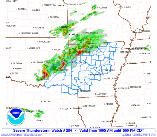
STATUS FOR WATCH 0284 HAS NOT BEEN ISSUED YET
https://www.spc.noaa.gov/products/watch/ws0284.html
date: 2024-05-22, from: NOAA tornado/severe thunderstorm watches, mesoscale discussions, convective outlooks, fire weather outlooks

URGENT - IMMEDIATE BROADCAST REQUESTED
Severe Thunderstorm Watch Number 284
NWS Storm Prediction Center Norman OK
1005 AM CDT Wed May 22 2024

The NWS Storm Prediction Center has issued a

* Severe Thunderstorm Watch for portions of
  Central and Western Arkansas
  Southeast Oklahoma
  Northeast Texas

* Effective this Wednesday morning and afternoon from 1005 AM
  until 500 PM CDT.

* Primary threats include...
  Scattered large hail and isolated very large hail events to 2.5
    inches in diameter likely
  Scattered damaging winds likely with isolated significant gusts
    to 75 mph possible
  A tornado or two possible

SUMMARY...Intensifying thunderstorms over eastern Oklahoma will
track across Arkansas through the afternoon, posing a risk of large
hail and damaging winds.

The severe thunderstorm watch area is approximately along and 90
statute miles east and west of a line from 35 miles west southwest
of De Queen AR to 40 miles northwest of Batesville AR. For a
complete depiction of the watch see the associated watch outline
update (WOUS64 KWNS WOU4).

PRECAUTIONARY/PREPAREDNESS ACTIONS...

REMEMBER...A Severe Thunderstorm Watch means conditions are
favorable for severe thunderstorms in and close to the watch area.
Persons in these areas should be on the lookout for threatening
weather conditions and listen for later statements and possible
warnings. Severe thunderstorms can and occasionally do produce
tornadoes.

&&

AVIATION...A few severe thunderstorms with hail surface and aloft to
2.5 inches. Extreme turbulence and surface wind gusts to 65 knots. A
few cumulonimbi with maximum tops to 500. Mean storm motion vector
27030.

...Hart
https://www.spc.noaa.gov/products/watch/ww0284.html
date: 2024-05-22, from: NOAA tornado/severe thunderstorm watches, mesoscale discussions, convective outlooks, fire weather outlooks

Day 1 Convective Outlook
NWS Storm Prediction Center Norman OK
0753 AM CDT Wed May 22 2024

Valid 221300Z - 231200Z

...THERE IS AN ENHANCED RISK OF SEVERE THUNDERSTORMS ACROSS PARTS OF
CENTRAL TEXAS TO CENTRAL ARKANSAS...

...SUMMARY...
Within a long swath of severe-thunderstorm potential from central
Texas to the Lower Great Lakes, the greatest concentration of severe
weather (mainly large hail and damaging wind) should be across parts
of central Texas to central Arkansas.  A few tornadoes are also
possible.

...Synopsis...
An active mid/upper-level pattern persists southeast through
southwest of a longstanding cyclone over southern SK and paths of
southern MB.  That circulation will continue to meander erratically
near its present location through the period.  Meanwhile, a train of
shortwaves will cross the northwestern and central CONUS and Great
Lakes regions.  A strong shortwave trough -- with embedded 500-mb
low now over ON near the MN border -- should become stacked with its
deep surface cyclone this morning and drift erratically over ON
northwest of Lake Superior today.  The stacked low then should eject
toward James Bay tonight.

The associated cold front -- analyzed at 11Z from northern Lower MI
to southern IL, northwestern AR, southern OK, and northwest TX to
the Permian Basin -- should move by 00Z to near a line from
CLE-EVV-ARG-DUA-SJT-CNM.  The cold front should cross the lower
Great Lakes and much of NY through the end of the period, while
decelerating across parts of the lower/middle Ohio Valley.  The
western part of the front should become more diffuse and retreat
northward overnight across the southern Plains.  This will occur as
low-level mass response (including warm advection) intensifies,
ahead of a mid/upper cyclone moving eastward across the northwestern
CONUS toward the western WY/eastern ID region.  A dryline --
initially drawn over the Big Bend region south of the front --
should mix eastward to northern Coahuila and a frontal intersection
over west-central TX by mid/late afternoon.

...Southern Plains to Arklatex region...
A broken swath of elevated thunderstorms is ongoing over parts of
central OK to southeastern KS.  Isolated large hail is the main
concern, and should be for a few more hours.  Some of this activity
may aggregate into a broader belt or cluster of convection and shift
eastward to southeastward through the day, toward the front.

Additional thunderstorms should develop from midday through this
afternoon along/ahead of the front and mid/late afternoon near the
dryline, with the near-frontal activity having the longest and
strongest organizational potential.  A few supercells are expected
early in the convective cycle, and any supercell that stays
relatively discrete well into maturity will pose a risk of large to
giant hail.  Storm-scale/boundary processes also may locally boost
tornado potential.  Activity should grow upscale into the evening --
perhaps merging with remnants of earlier activity moving
southeastward from OK toward the surface front.  As this occurs, the
main threat will transition to damaging and severe gusts.  The
"enhanced" area represents the overlap of greatest hail and wind
probabilities with this transitional regime.

The warm sector southeast of the front, and east of the dryline,
will remain very moist -- characterized by upper 60s to mid 70s F
surface dew points.  Underlying steep midlevel lapse rates, and with
strong surface heating anticipated, the result should be a corridor
of 3000-4000 J/kg MLCAPE.  Given the strong heating and high ambient
theta-e, convective temperature may be attained even in the free
warm sector (away from the front and dryline), and despite the
prevalent EML.  Though forecast soundings show weaknesses in the
flow around 2-3 km, both low-level and deep-layer shear (effective-
shear magnitudes 55-65 kt) and lengthy hodographs will be present,
supporting potential for locally destructive hail.  Severe
downdrafts also are possible, both from individual supercells and
from convection resulting from aggregated cold pools.  The overall
threat should decrease with this activity as it shifts eastward-
southeastward toward south/east TX and over LA tonight.  However,
additional development atop the outflow may occur tonight farther
north near the Red River, helping to maintain some severe threat
(mainly in the form of hail and isolated severe gusts).

...Mid-South to Ohio Valley and lower Great Lakes...
Widely scattered to scattered thunderstorms, some in clusters, are
expected along this corridor from mid afternoon through the evening.
Damaging gusts will be the main concern, with isolated large hail
also possible. A marginal tornado threat also may develop,
particularly over portions of central/eastern OH to northwestern PA
and perhaps southwestern upstate NY, where low-level and deep shear
will be most favorable.

Once some ongoing clouds/precip over the Ohio Valley move away and
break up, surface heating should destabilize the boundary layer, in
concert with dewpoints commonly in the 60s F. This should yield a
prefrontal corridor of MLCAPE ranging from near 3000 J/kg over parts
of the Mid-South (where deep-layer lapse rates will be steepest) to
around 1500 J/kg over the area adjoining the lower Great Lakes.
35-45-kt effective-shear magnitudes will support a mix of multicell
and supercell modes, with upscale growth/clustering tending to limit
duration of supercells.

..Edwards/Goss.. 05/22/2024
https://www.spc.noaa.gov/products/outlook/day1otlk_1300.html
date: 2024-05-22, from: Graphical Tropical Weather Outlooks
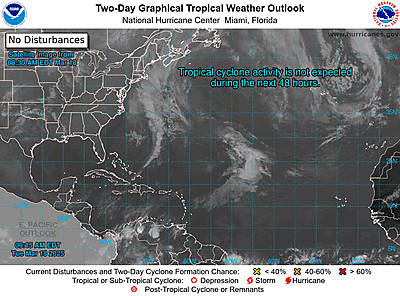
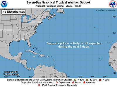
https://www.nhc.noaa.gov/gtwo.php?basin=atlc
date: 2024-05-22, from: Eastern Pacific Tropical Weather Outlook
000
ABPZ20 KNHC 221118
TWOEP
Tropical Weather Outlook
NWS National Hurricane Center Miami
FL
500 AM PDT Wed May 22 2024
For the eastern North
Pacific…east of 140 degrees west longitude:
Tropical
cyclone formation is not expected during the next 7 days.
$$
Forecaster Kelly
https://www.nhc.noaa.gov/gtwo.php?basin=epac
date: 2024-05-22, from: NOAA Weather Forecasts
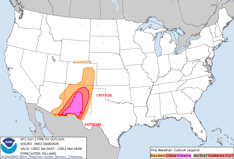
Day 2 Fire Weather Outlook
NWS Storm Prediction Center Norman OK
0216 AM CDT Wed May 22 2024

Valid 231200Z - 241200Z

...CRITICAL FIRE WEATHER AREA FOR SOUTHERN/EASTERN NEW MEXICO AND
THE UPPER TRANS-PECOS...

...Synopsis...
Increasing deep westerly flow within the base of a large-scale
trough, along with a deepening lee surface cyclone over the High
Plains, will result in critical surface wind speeds developing
across portions of southern and eastern NM, and the Upper
Trans-Pecos region of TX Thursday afternoon. This, combined with
increasingly receptive fuels and widespread single-digit RH, has led
to the introduction of a Critical area.

..Barnes.. 05/22/2024

...Please see www.spc.noaa.gov/fire for graphic product...
https://www.spc.noaa.gov/products/fire_wx/fwdy2.html
date: 2024-05-21, from: NOAA tornado/severe thunderstorm watches, mesoscale discussions, convective outlooks, fire weather outlooks
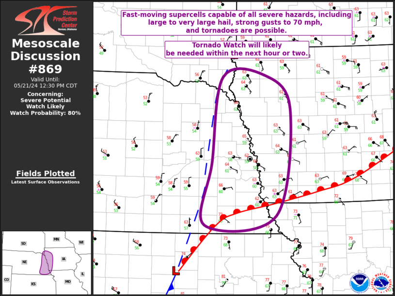
Mesoscale Discussion 0869
NWS Storm Prediction Center Norman OK
1027 AM CDT Tue May 21 2024

Areas affected...Eastern NE...Western IA...Far Southeast SD

Concerning...Severe potential...Watch likely

Valid 211527Z - 211730Z

Probability of Watch Issuance...80 percent

SUMMARY...Fast-moving supercells capable of all severe hazards will
be possible, including large to very large hail, strong gusts up to
70 mph, and tornadoes. A Tornado Watch will likely be needed for
portions of the area with in the next hour or two.

DISCUSSION...Recent surface analysis places the primary surface low
over north-central KS (just southwest of CNK), with a warm front
extending northeastward into southeast NE and then more
east-northeastward across southern IA. A cold front also extends
from this low southwestward through central KS and the eastern OK
Panhandle. There is a secondary surface low farther north near the
IA/SD/MN border intersection, with weak surface troughing connecting
these two lows.

Given the position of the surface features, the recent thunderstorm
activity along the central NE/KS border is likely elevated,
initiated by strong ascent attendant to the approaching shortwave
trough. However, as the primary surface low moves quickly
northeastward, and the warm front correspondingly moves northward,
the airmass across eastern NE and western IA (particularly
east-central/southeast NE and west-central/southwest IA) is expected
to become increasingly supportive of surface-based storms. Within
the warm sector, fast-moving supercells capable of all severe
hazards will be possible, including large to very large hail, strong
gusts up to 70 mph, and tornadoes. Large hail and strong gusts will
be possible with the elevated storms as well. Given this severe
potential, a Tornado Watch will likely be needed for portions of the
area with in the next hour or two.

..Mosier/Guyer.. 05/21/2024

...Please see www.spc.noaa.gov for graphic product...

ATTN...WFO...DMX...EAX...FSD...OAX...

LAT...LON   41339704 42939678 42989574 42349509 40339546 40159723
            41339704
https://www.spc.noaa.gov/products/md/md0869.html
date: 2024-05-21, from: NOAA tornado/severe thunderstorm watches, mesoscale discussions, convective outlooks, fire weather outlooks
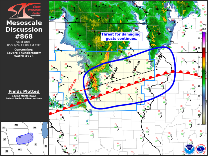
Mesoscale Discussion 0868
NWS Storm Prediction Center Norman OK
0929 AM CDT Tue May 21 2024

Areas affected...Central/Eastern IA...Far Southwest WI...Far
Northwest IL

Concerning...Severe Thunderstorm Watch 275...

Valid 211429Z - 211600Z

The severe weather threat for Severe Thunderstorm Watch 275
continues.

SUMMARY...Threat for damaging gusts will continue across central and
eastern IA for the next few hours.

DISCUSSION...A convective line continues over central IA, with
recent storm motion estimated to be northeastward at 40-45 kt. This
motion takes the line into more of eastern IA between 15Z and 16Z.
Recent surface analysis places a warm front from far southwest IA
northeastward to south of CID and then eastward into northern IL.
The ongoing convective line is currently north of this boundary,
with the elevated character to this line likely contributing to the
lack of measured surface gusts. The southwest-to-northeast
orientation of the warm front and its somewhat slow motion north
coupled with the predominantly northeastward motion of the line
casts some doubt to whether or not this line will be able to evolve
towards a more surface-based character with eastern extent. If it
does, some trend towards stronger and more frequent gusts is
possible. Even if the line remains elevated, the overall environment
is expected to improve as it moves downstream, with damaging gusts
remaining possible.

Additionally, given the improving environmental conditions
anticipated, overall convective trends will be monitored for
potential downstream watch issuance into northwest IL and southwest
WI.

..Mosier.. 05/21/2024

...Please see www.spc.noaa.gov for graphic product...

ATTN...WFO...MKX...DVN...ARX...DMX...

LAT...LON   41669404 42109334 42329230 42679031 41559005 41009096
            40769245 40729362 41669404
https://www.spc.noaa.gov/products/md/md0868.html
date: 2024-05-21, from: NOAA tornado/severe thunderstorm watches, mesoscale discussions, convective outlooks, fire weather outlooks
PUBLIC SEVERE WEATHER OUTLOOK
NWS STORM PREDICTION CENTER NORMAN OK
0827 AM CDT TUE MAY 21 2024

...Severe thunderstorms expected over parts of the Midwest this
afternoon and tonight...

* LOCATIONS...
  Iowa
  Northern Illinois
  Northern Missouri
  Southern Wisconsin
  Southeast Minnesota
  Far Eastern Kansas
  Eastern Nebraska

* HAZARDS...
  Widespread damaging winds, some hurricane force
  Several tornadoes, a few intense
  Widespread large hail, some baseball size

* SUMMARY...
  An outbreak of severe thunderstorms, including the potential for
  strong tornadoes, is expected mainly this afternoon to early
  evening. The greatest threat is over Iowa and parts of adjacent
  states.

Preparedness actions...

Review your severe weather safety procedures for the possibility
of dangerous weather today. Stay tuned to NOAA Weather Radio,
weather.gov, or other media for watches and warnings. A watch
means that conditions are favorable for severe thunderstorms
over the next several hours. If a severe thunderstorm warning is
issued for your area, move to a place of safety, ideally in an
interior room on the lowest floor of a sturdy building.
https://www.spc.noaa.gov/products/outlook/pwo.html
date: 2024-05-21, from: NOAA tornado/severe thunderstorm watches, mesoscale discussions, convective outlooks, fire weather outlooks
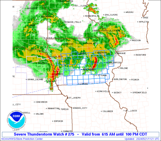
STATUS FOR WATCH 0275 HAS NOT BEEN ISSUED YET
https://www.spc.noaa.gov/products/watch/ws0275.html
date: 2024-05-21, from: NOAA tornado/severe thunderstorm watches, mesoscale discussions, convective outlooks, fire weather outlooks

URGENT - IMMEDIATE BROADCAST REQUESTED
Severe Thunderstorm Watch Number 275
NWS Storm Prediction Center Norman OK
615 AM CDT Tue May 21 2024

The NWS Storm Prediction Center has issued a

* Severe Thunderstorm Watch for portions of
  Central and southern Iowa

* Effective this Tuesday morning and afternoon from 615 AM until
  100 PM CDT.

* Primary threats include...
  Scattered damaging winds and isolated significant gusts to 75
    mph possible
  Isolated large hail events to 1.5 inches in diameter possible
  A tornado or two possible

SUMMARY...Clusters of thunderstorms -- including an organized bowing
complex initially over eastern NE -- will pose a threat mainly for
severe gusts while crossing the watch area from west to east.  A
tornado or two cannot be ruled out, especially near an outflow
boundary draped across central/south-central IA.  Isolated large
hail is possible.  This is a precursor to the main severe-weather
threat expected later today, for which we have a "Moderate Risk"
outlook.

The severe thunderstorm watch area is approximately along and 60
statute miles north and south of a line from 80 miles west of Des
Moines IA to 25 miles south southeast of Cedar Rapids IA. For a
complete depiction of the watch see the associated watch outline
update (WOUS64 KWNS WOU5).

PRECAUTIONARY/PREPAREDNESS ACTIONS...

REMEMBER...A Severe Thunderstorm Watch means conditions are
favorable for severe thunderstorms in and close to the watch area.
Persons in these areas should be on the lookout for threatening
weather conditions and listen for later statements and possible
warnings. Severe thunderstorms can and occasionally do produce
tornadoes.

&&

OTHER WATCH INFORMATION...CONTINUE...WW 274...

AVIATION...A few severe thunderstorms with hail surface and aloft to
1.5 inches. Extreme turbulence and surface wind gusts to 65 knots. A
few cumulonimbi with maximum tops to 550. Mean storm motion vector
26045.

...Edwards
https://www.spc.noaa.gov/products/watch/ww0275.html
date: 2024-05-21, from: NOAA tornado/severe thunderstorm watches, mesoscale discussions, convective outlooks, fire weather outlooks

Mesoscale Discussion 0859
NWS Storm Prediction Center Norman OK
0825 PM CDT Mon May 20 2024

Areas affected...parts of southwestern Nebraska and adjacent
northern Kansas

Concerning...Severe potential...Watch likely

Valid 210125Z - 210300Z

Probability of Watch Issuance...80 percent

SUMMARY...An intensifying supercell and perhaps small upscale
growing convective cluster appears likely to continue developing
eastward along a frontal zone into portions of southwestern Nebraska
and adjacent northern Kansas through 10 PM-Midnight CDT.  This will
be accompanied by increasing potential for large hail, severe wind
gusts and a few tornadoes.  A new watch likely will be issued within
the next hour or so.

DISCUSSION...More substantive intensification of convection across
northeastern Colorado is now underway, including one supercell now
propagating eastward across the Akron CO vicinity.  As activity
continues eastward, strengthening easterly low-level updraft inflow
will become increasingly unstable with deeper progression into the
plains.  This likely will support further upscale growth, including,
at least initially, an enlarging supercell, then perhaps a gradually
upscale growing cluster focused along the baroclinic zone (roughly
centered around 700 mb) extending eastward near/north of the
Kansas/Nebraska border vicinity.

..Kerr/Thompson.. 05/21/2024

...Please see www.spc.noaa.gov for graphic product...

ATTN...WFO...GID...LBF...GLD...BOU...

LAT...LON   40930201 41000060 40679972 39699985 39580095 39680163
            40140214 40930201
https://www.spc.noaa.gov/products/md/md0859.html
date: 2024-05-21, from: NOAA tornado/severe thunderstorm watches, mesoscale discussions, convective outlooks, fire weather outlooks

Mesoscale Discussion 0860
NWS Storm Prediction Center Norman OK
0923 PM CDT Mon May 20 2024

Areas affected...Northern Iowa and southern Minnesota

Concerning...Severe Thunderstorm Watch 272...

Valid 210223Z - 210400Z

The severe weather threat for Severe Thunderstorm Watch 272
continues.

SUMMARY...Discrete supercells capable of producing large hail up to
2.0 inches in diameter remain possible across northern IA this
evening. Damaging wind gusts could also accompany collapsing
thunderstorms.

DISCUSSION...A couple of discrete, right moving supercells have
evolved this evening over Cherokee, Clay, and Palo Alto Counties.
Recent FSD VAD profiler data indicates deep layer shear magnitudes
around 50 kt. Although slightly weaker shear is likely present
further east and southeast, where ongoing supercells are persisting,
the discrete nature of them along a nearly stationary boundary may
be supporting localized storm pressure perturbations capable of
significant updraft velocities. In addition, steep mid-level lapse
rates/large CAPE within the hail growth zone (00Z OAX sounding) is
also contributing larger hail potential. However, as MLCINH
continues to increase updraft strength should slowly diminish and
hail sizes should decrease. The severe threat will continue through
the late evening hours along and just behind the surface front,
where some elevated supercells will also be possible.

..Barnes.. 05/21/2024

...Please see www.spc.noaa.gov for graphic product...

ATTN...WFO...ARX...MPX...DMX...FSD...

LAT...LON   43289652 43379589 43559581 43569547 43909542 44249439
            44279275 44369242 44189199 43759173 43359190 43029245
            42879296 42809338 42609369 42419415 42279456 42149501
            42299640 42769660 43289652
https://www.spc.noaa.gov/products/md/md0860.html
date: 2024-05-21, from: NOAA tornado/severe thunderstorm watches, mesoscale discussions, convective outlooks, fire weather outlooks
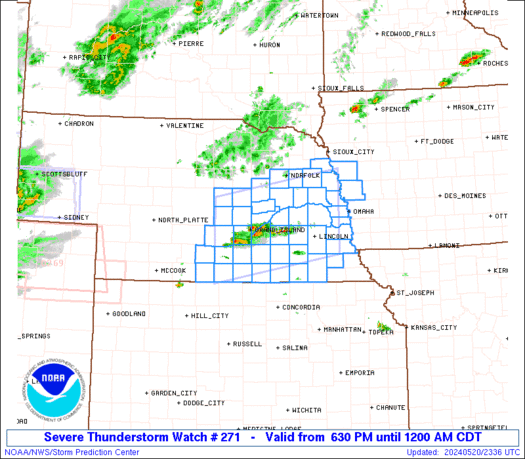
URGENT - IMMEDIATE BROADCAST REQUESTED
Severe Thunderstorm Watch Number 271
NWS Storm Prediction Center Norman OK
630 PM CDT Mon May 20 2024

The NWS Storm Prediction Center has issued a

* Severe Thunderstorm Watch for portions of
  Extreme west central Iowa
  South central into east central and southeast Nebraska

* Effective this Monday night from 630 PM until Midnight CDT.

* Primary threats include...
  Scattered large hail likely with isolated very large hail events
    to 2 inches in diameter possible
  Scattered damaging wind gusts to 70 mph possible

SUMMARY...Scattered thunderstorms are expected to form this evening,
within an environment supporting supercells.  Large hail of 1-2
inches in diameter and outflow gusts of 60-70 mph will be the main
threats through early tonight.

The severe thunderstorm watch area is approximately along and 55
statute miles north and south of a line from 10 miles west northwest
of Kearney NE to 45 miles northeast of Lincoln NE. For a complete
depiction of the watch see the associated watch outline update
(WOUS64 KWNS WOU1).

PRECAUTIONARY/PREPAREDNESS ACTIONS...

REMEMBER...A Severe Thunderstorm Watch means conditions are
favorable for severe thunderstorms in and close to the watch area.
Persons in these areas should be on the lookout for threatening
weather conditions and listen for later statements and possible
warnings. Severe thunderstorms can and occasionally do produce
tornadoes.

&&

OTHER WATCH INFORMATION...CONTINUE...WW 268...WW 269...WW 270...

AVIATION...A few severe thunderstorms with hail surface and aloft to
2 inches. Extreme turbulence and surface wind gusts to 60 knots. A
few cumulonimbi with maximum tops to 500. Mean storm motion vector
24020.

...Thompson
https://www.spc.noaa.gov/products/watch/ww0271.html
date: 2024-05-21, from: NOAA tornado/severe thunderstorm watches, mesoscale discussions, convective outlooks, fire weather outlooks

STATUS REPORT ON WW 271

THE SEVERE WEATHER THREAT CONTINUES ACROSS THE ENTIRE WATCH AREA.

..KERR..05/21/24

ATTN...WFO...OAX...GID...


STATUS REPORT FOR WS 271

SEVERE WEATHER THREAT CONTINUES FOR THE FOLLOWING AREAS

IAC085-133-210340-

IA
.    IOWA COUNTIES INCLUDED ARE

HARRISON             MONONA


NEC001-019-021-023-025-035-037-053-055-059-061-067-079-081-083-
093-095-097-099-109-121-125-129-131-137-141-143-151-153-155-159-
169-177-181-185-210340-

NE
.    NEBRASKA COUNTIES INCLUDED ARE

ADAMS                BUFFALO             BURT
BUTLER               CASS                CLAY
COLFAX               DODGE               DOUGLAS
FILLMORE             FRANKLIN            GAGE
HALL                 HAMILTON            HARLAN
HOWARD               JEFFERSON           JOHNSON
KEARNEY              LANCASTER           MERRICK
NANCE                NUCKOLLS            OTOE
PHELPS               PLATTE              POLK
SALINE               SARPY               SAUNDERS
SEWARD               THAYER              WASHINGTON
https://www.spc.noaa.gov/products/watch/ws0271.html
date: 2024-05-21, from: NOAA tornado/severe thunderstorm watches, mesoscale discussions, convective outlooks, fire weather outlooks
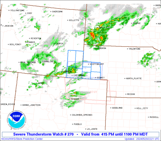
STATUS REPORT ON WW 270

SEVERE WEATHER THREAT CONTINUES RIGHT OF A LINE FROM 35 W SNY TO
5 ESE TOR.

..KERR..05/21/24

ATTN...WFO...CYS...


STATUS REPORT FOR WS 270

SEVERE WEATHER THREAT CONTINUES FOR THE FOLLOWING AREAS

NEC007-033-105-123-157-210340-

NE
.    NEBRASKA COUNTIES INCLUDED ARE

BANNER               CHEYENNE            KIMBALL
MORRILL              SCOTTS BLUFF


THE WATCH STATUS MESSAGE IS FOR GUIDANCE PURPOSES ONLY.  PLEASE
REFER TO WATCH COUNTY NOTIFICATION STATEMENTS FOR OFFICIAL
INFORMATION ON COUNTIES...INDEPENDENT CITIES AND MARINE ZONES
CLEARED FROM SEVERE THUNDERSTORM AND TORNADO WATCHES.
https://www.spc.noaa.gov/products/watch/ws0270.html
date: 2024-05-21, from: NOAA tornado/severe thunderstorm watches, mesoscale discussions, convective outlooks, fire weather outlooks

URGENT - IMMEDIATE BROADCAST REQUESTED
Severe Thunderstorm Watch Number 270
NWS Storm Prediction Center Norman OK
415 PM MDT Mon May 20 2024

The NWS Storm Prediction Center has issued a

* Severe Thunderstorm Watch for portions of
  Southwest Nebraska Panhandle
  Southeast Wyoming

* Effective this Monday afternoon and evening from 415 PM until
  1100 PM MDT.

* Primary threats include...
  Scattered large hail events to 1.5 inches in diameter possible
  Isolated damaging wind gusts to 70 mph possible

SUMMARY...Scattered severe storms are expected to from and spread
east-northeastward across southeast Wyoming and the southwest
Nebraska Panhandle, with the primary threats of hail 1-1.5 inches in
diameter and severe gusts of 60-70 mph.

The severe thunderstorm watch area is approximately along and 70
statute miles east and west of a line from 15 miles west northwest
of Scottsbluff NE to 45 miles west of Sidney NE. For a complete
depiction of the watch see the associated watch outline update
(WOUS64 KWNS WOU0).

PRECAUTIONARY/PREPAREDNESS ACTIONS...

REMEMBER...A Severe Thunderstorm Watch means conditions are
favorable for severe thunderstorms in and close to the watch area.
Persons in these areas should be on the lookout for threatening
weather conditions and listen for later statements and possible
warnings. Severe thunderstorms can and occasionally do produce
tornadoes.

&&

OTHER WATCH INFORMATION...CONTINUE...WW 268...WW 269...

AVIATION...A few severe thunderstorms with hail surface and aloft to
1.5 inches. Extreme turbulence and surface wind gusts to 60 knots. A
few cumulonimbi with maximum tops to 450. Mean storm motion vector
25025.

...Thompson
https://www.spc.noaa.gov/products/watch/ww0270.html
date: 2024-05-21, from: NOAA tornado/severe thunderstorm watches, mesoscale discussions, convective outlooks, fire weather outlooks
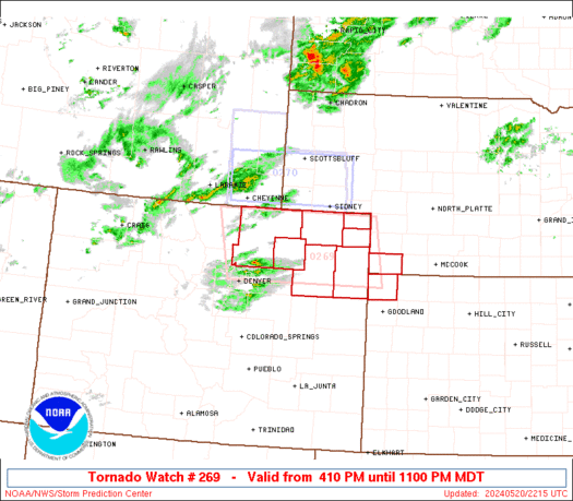
URGENT - IMMEDIATE BROADCAST REQUESTED
Tornado Watch Number 269
NWS Storm Prediction Center Norman OK
410 PM MDT Mon May 20 2024

The NWS Storm Prediction Center has issued a

* Tornado Watch for portions of
  Northeast Colorado
  Extreme northwest Kansas
  Extreme southwest Nebraska

* Effective this Monday afternoon and evening from 410 PM until
  1100 PM MDT.

* Primary threats include...
  A couple tornadoes possible
  Scattered large hail and isolated very large hail events to 2.5
    inches in diameter likely
  Scattered damaging wind gusts to 70 mph possible

SUMMARY...A few supercells are expected to form this evening across
northeast CO, and the storms will then move east-northeastward
toward extreme southwest Nebraska and northwest Kansas through late
evening/early tonight.  Very large hail to 2.5 inches in diameter
and severe gusts of 60-70 mph will be the main threats, though a
gradual increase in low-level moisture later this evening will
support the potential for a couple of tornadoes.

The tornado watch area is approximately along and 90 statute miles
east and west of a line from 60 miles north northwest of Akron CO to
30 miles south southwest of Akron CO. For a complete depiction of
the watch see the associated watch outline update (WOUS64 KWNS
WOU9).

PRECAUTIONARY/PREPAREDNESS ACTIONS...

REMEMBER...A Tornado Watch means conditions are favorable for
tornadoes and severe thunderstorms in and close to the watch
area. Persons in these areas should be on the lookout for
threatening weather conditions and listen for later statements
and possible warnings.

&&

OTHER WATCH INFORMATION...CONTINUE...WW 268...

AVIATION...Tornadoes and a few severe thunderstorms with hail
surface and aloft to 2.5 inches. Extreme turbulence and surface wind
gusts to 60 knots. A few cumulonimbi with maximum tops to 450. Mean
storm motion vector 26025.

...Thompson
https://www.spc.noaa.gov/products/watch/ww0269.html
date: 2024-05-21, from: NOAA tornado/severe thunderstorm watches, mesoscale discussions, convective outlooks, fire weather outlooks

STATUS REPORT ON WW 269

SEVERE WEATHER THREAT CONTINUES RIGHT OF A LINE FROM 15 E DEN TO
35 WNW AKO TO 10 SW SNY.

..KERR..05/21/24

ATTN...WFO...BOU...GLD...


STATUS REPORT FOR WT 269

SEVERE WEATHER THREAT CONTINUES FOR THE FOLLOWING AREAS

COC075-087-095-115-121-210340-

CO
.    COLORADO COUNTIES INCLUDED ARE

LOGAN                MORGAN              PHILLIPS
SEDGWICK             WASHINGTON


THE WATCH STATUS MESSAGE IS FOR GUIDANCE PURPOSES ONLY.  PLEASE
REFER TO WATCH COUNTY NOTIFICATION STATEMENTS FOR OFFICIAL
INFORMATION ON COUNTIES...INDEPENDENT CITIES AND MARINE ZONES
CLEARED FROM SEVERE THUNDERSTORM AND TORNADO WATCHES.
https://www.spc.noaa.gov/products/watch/ws0269.html
date: 2024-05-21, from: NOAA tornado/severe thunderstorm watches, mesoscale discussions, convective outlooks, fire weather outlooks
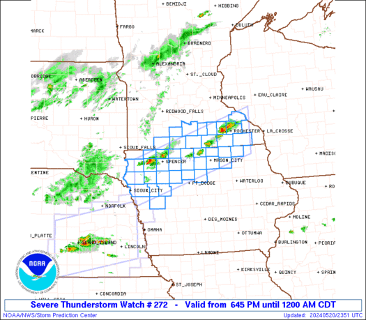
STATUS REPORT ON WW 272

THE SEVERE WEATHER THREAT CONTINUES ACROSS THE ENTIRE WATCH AREA.

FOR ADDITIONAL INFORMATION SEE MESOSCALE DISCUSSION 0860

..BENTLEY..05/21/24

ATTN...WFO...FSD...DMX...ARX...MPX...


STATUS REPORT FOR WS 272

SEVERE WEATHER THREAT CONTINUES FOR THE FOLLOWING AREAS

IAC021-033-035-041-047-059-063-067-081-089-091-093-109-131-141-
143-147-149-151-161-167-189-193-195-197-210340-

IA
.    IOWA COUNTIES INCLUDED ARE

BUENA VISTA          CERRO GORDO         CHEROKEE
CLAY                 CRAWFORD            DICKINSON
EMMET                FLOYD               HANCOCK
HOWARD               HUMBOLDT            IDA
KOSSUTH              MITCHELL            O'BRIEN
OSCEOLA              PALO ALTO           PLYMOUTH
POCAHONTAS           SAC                 SIOUX
WINNEBAGO            WOODBURY            WORTH
WRIGHT


MNC013-039-043-045-047-063-091-099-109-147-157-161-165-210340-

MN
.    MINNESOTA COUNTIES INCLUDED ARE

BLUE EARTH           DODGE               FARIBAULT
FILLMORE             FREEBORN            JACKSON
https://www.spc.noaa.gov/products/watch/ws0272.html
date: 2024-05-21, from: NOAA tornado/severe thunderstorm watches, mesoscale discussions, convective outlooks, fire weather outlooks

URGENT - IMMEDIATE BROADCAST REQUESTED
Severe Thunderstorm Watch Number 272
NWS Storm Prediction Center Norman OK
645 PM CDT Mon May 20 2024

The NWS Storm Prediction Center has issued a

* Severe Thunderstorm Watch for portions of
  Northwest and north central Iowa
  South central and southeast Minnesota

* Effective this Monday night from 645 PM until Midnight CDT.

* Primary threats include...
  Scattered damaging wind gusts to 60 mph possible
  Scattered large hail events to 1.5 inches in diameter possible

SUMMARY...Scattered thunderstorm development is expected this
evening along a slow moving front across southern Minnesota and
northern Iowa.  The storm environment will favor a mix of multicell
clusters and storms with supercell structure capable of producing
large hail of 1-1.5 inches in diameter and damaging outflow gusts up
to 60 mph.

The severe thunderstorm watch area is approximately along and 45
statute miles north and south of a line from 35 miles east of
Rochester MN to 50 miles west of Storm Lake IA. For a complete
depiction of the watch see the associated watch outline update
(WOUS64 KWNS WOU2).

PRECAUTIONARY/PREPAREDNESS ACTIONS...

REMEMBER...A Severe Thunderstorm Watch means conditions are
favorable for severe thunderstorms in and close to the watch area.
Persons in these areas should be on the lookout for threatening
weather conditions and listen for later statements and possible
warnings. Severe thunderstorms can and occasionally do produce
tornadoes.

&&

OTHER WATCH INFORMATION...CONTINUE...WW 268...WW 269...WW
270...WW 271...

AVIATION...A few severe thunderstorms with hail surface and aloft to
1.5 inches. Extreme turbulence and surface wind gusts to 50 knots. A
few cumulonimbi with maximum tops to 500. Mean storm motion vector
27020.

...Thompson
https://www.spc.noaa.gov/products/watch/ww0272.html
date: 2024-05-21, from: NOAA tornado/severe thunderstorm watches, mesoscale discussions, convective outlooks, fire weather outlooks

STATUS FOR WATCH 0273 HAS NOT BEEN ISSUED YET
https://www.spc.noaa.gov/products/watch/ws0273.html
date: 2024-05-21, from: NOAA tornado/severe thunderstorm watches, mesoscale discussions, convective outlooks, fire weather outlooks

URGENT - IMMEDIATE BROADCAST REQUESTED
Tornado Watch Number 273
NWS Storm Prediction Center Norman OK
855 PM CDT Mon May 20 2024

The NWS Storm Prediction Center has issued a

* Tornado Watch for portions of
  Extreme northeast Colorado
  Extreme northwest Kansas
  Southwest Nebraska

* Effective this Monday night and Tuesday morning from 855 PM
  until 300 AM CDT.

* Primary threats include...
  A few tornadoes likely with a couple intense tornadoes possible
  Scattered damaging winds and isolated significant gusts to 80
    mph likely
  Scattered large hail and isolated very large hail events to 3
    inches in diameter likely

SUMMARY...Clusters of intensifying supercells across northeast
Colorado will continue eastward into Kansas/Nebraska with some
potential for upscale growth tonight.  The storm environment will
favor all significant hazards of all types (tornadoes capable of EF2
damage, very large hail up to 3 inches in diameter, and severe
outflow winds up to 80 mph).

The tornado watch area is approximately along and 55 statute miles
north and south of a line from 25 miles west of Imperial NE to 35
miles northeast of Mccook NE. For a complete depiction of the watch
see the associated watch outline update (WOUS64 KWNS WOU3).

PRECAUTIONARY/PREPAREDNESS ACTIONS...

REMEMBER...A Tornado Watch means conditions are favorable for
tornadoes and severe thunderstorms in and close to the watch
area. Persons in these areas should be on the lookout for
threatening weather conditions and listen for later statements
and possible warnings.

&&

OTHER WATCH INFORMATION...CONTINUE...WW 268...WW 269...WW
270...WW 271...WW 272...

AVIATION...Tornadoes and a few severe thunderstorms with hail
surface and aloft to 3 inches. Extreme turbulence and surface wind
gusts to 70 knots. A few cumulonimbi with maximum tops to 500. Mean
storm motion vector 27030.

...Thompson
https://www.spc.noaa.gov/products/watch/ww0273.html
date: 2024-05-21, from: NOAA tornado/severe thunderstorm watches, mesoscale discussions, convective outlooks, fire weather outlooks

Day 1 Convective Outlook
NWS Storm Prediction Center Norman OK
0759 PM CDT Mon May 20 2024

Valid 210100Z - 211200Z

...THERE IS AN ENHANCED RISK OF SEVERE THUNDERSTORMS IN THE CENTRAL
HIGH PLAINS ACROSS SOUTHERN NE...

...SUMMARY...
Scattered severe thunderstorms are expected through tonight from the
central High Plains to parts of the Upper Midwest. The greatest
concentration of tornadoes, large hail, and severe wind is expected
over northeast Colorado into southern Nebraska, and far northwest
Kansas. This will include potential for a strong tornado, very large
hail, and significant severe gusts.

...01Z Update...
Primary concern is with ongoing convection developing across
northeast CO into the southwest NE Panhandle. With a current of east
to southeast 0-1 km winds expected to increase during the next few
hours, afternoon CAM guidance along with recent WoFS runs are
insistent on long-lived supercell development along the southern
flank of the thunderstorm plume. This appears likely to emanate out
of the Akron, CO vicinity and move east towards the CO/KS/NE border
area. With low 60s surface dew points across northwest KS marking
the northwest extent of MLCAPE in excess of 1500 J/kg, a supercell
or two impinging on the increasingly buoyant airmass downstream, may
become intense. In addition to the risk for very large hail,
enlarging low-level hodographs will support potential for cyclic
tornadogenesis, especially in the 02-05Z time frame. Transition from
tornadic supercell to a bow will likely occur during the late
evening to early morning, with probable movement along the
pronounced MLCAPE gradient into at least south-central NE.
Increasingly large MLCIN is anticipated overnight across KS,
suggesting that the severe wind swath will remain latitudinally
confined. Downstream convection, ongoing across southeast NE,
suggests the upstream severe wind threat may wane somewhat near dawn
as the MCS approaches the Mid-MO Valley. But the potential for a
well-organized MCS to persist across much of southern NE is apparent
and warrants expansion of the level 3-ENH risk.

Elsewhere, scattered large hail and sporadic severe wind gusts
should occur this evening into the early overnight from southeast NE
to southeast MN. A lower-end QLCS across Lower MI into northwest IN
may produce locally damaging winds with strong gusts through the
rest of this evening. But this convection will likely diminish
overnight.

..Grams.. 05/21/2024
https://www.spc.noaa.gov/products/outlook/day1otlk_0100.html
date: 2024-05-21, from: NOAA tornado/severe thunderstorm watches, mesoscale discussions, convective outlooks, fire weather outlooks
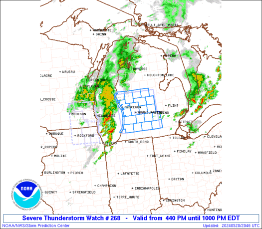
STATUS REPORT ON WW 268

SEVERE WEATHER THREAT CONTINUES RIGHT OF A LINE FROM 25 SSE AZO
TO 25 WSW LAN TO 35 WSW MBS TO 30 WNW MBS TO 25 S HTL.

WW 268 WILL BE ALLOWED TO EXPIRE AT 210200Z.

..BENTLEY..05/21/24

ATTN...WFO...GRR...


STATUS REPORT FOR WS 268

SEVERE WEATHER THREAT CONTINUES FOR THE FOLLOWING AREAS

MIC025-037-045-057-065-075-210200-

MI
.    MICHIGAN COUNTIES INCLUDED ARE

CALHOUN              CLINTON             EATON
GRATIOT              INGHAM              JACKSON


THE WATCH STATUS MESSAGE IS FOR GUIDANCE PURPOSES ONLY.  PLEASE
REFER TO WATCH COUNTY NOTIFICATION STATEMENTS FOR OFFICIAL
INFORMATION ON COUNTIES...INDEPENDENT CITIES AND MARINE ZONES
CLEARED FROM SEVERE THUNDERSTORM AND TORNADO WATCHES.
https://www.spc.noaa.gov/products/watch/ws0268.html
date: 2024-05-20, from: NOAA tornado/severe thunderstorm watches, mesoscale discussions, convective outlooks, fire weather outlooks
Day 3-8 Fire Weather Outlook
NWS Storm Prediction Center Norman OK
0449 PM CDT Mon May 20 2024

Valid 221200Z - 281200Z

...Southwest into the southern High Plains...

...Days 3-4/Wednesday-Thursday...
A broad large-scale trough will persist across the West, with the
strongest midlevel flow confined to the northwestern CONUS. Along
the southern periphery of the trough, moderate west-southwesterly
flow will overspread a dry/deeply mixed air mass from the Southwest
into the southern High Plains. As a result, elevated to locally
critical conditions are expected each afternoon, given increasingly
dry/receptive fuels across the region. 40-percent Critical
probabilities remain in place for these days, though confidence in
any more than locally critical conditions is too low to introduce
higher probabilities at this time.

...Days 5-6/Friday-Saturday...
On Day 5/Friday, west-southwesterly midlevel flow will strengthen
across the Southwest, where a warm/dry antecedent air mass will be
in place. Given the strengthening midlevel flow and a modest surface
pressure gradient, critical conditions are expected on Day 5/Friday
over northeast AZ and northwest NM. Thereafter, a robust midlevel
jet streak embedded in the west-southwesterlies will overspread the
Southwest and southern High Plains on Day 6/Saturday. This will
promote another day of dry/windy conditions across the region, with
the best overlap of strong surface winds and low RH atop receptive
fuels expected over southern NM, where critical conditions are
expected.

Elevated to locally critical conditions will likely continue on Day
7/Sunday, though midlevel flow will be slightly weaker than days
prior -- precluding 70-percent probabilities at this time.

..Weinman.. 05/20/2024

...Please see www.spc.noaa.gov/fire for graphic product...
https://www.spc.noaa.gov/products/exper/fire_wx/
date: 2024-05-20, from: NOAA tornado/severe thunderstorm watches, mesoscale discussions, convective outlooks, fire weather outlooks

Mesoscale Discussion 0851
NWS Storm Prediction Center Norman OK
1237 PM CDT Mon May 20 2024

Areas affected...the Michigan Thumb vicinity

Concerning...Severe potential...Watch unlikely

Valid 201737Z - 201930Z

Probability of Watch Issuance...20 percent

SUMMARY...Strong to severe storms capable of isolated damaging wind
and hail are possible this afternoon.

DISCUSSION...A cluster of storms has recently intensified near the
Thumb region of Michigan. While low-level moisture is relatively
limited, strong heating is occurring downstream of this cluster,
supporting MUCAPE of near or above 1000 J/kg. Deep-layer shear is
rather modest, but unidirectional southwesterly flow may support
some organization with this cluster as it moves northeastward
through the afternoon. Steepening low-level lapse rates will support
a threat for strong/damaging outflow gusts, while stronger embedded
cells may be capable of producing some hail. In addition, isolated
strong storm development cannot be ruled out later this afternoon to
the southwest of the ongoing cluster, along a trailing surface
boundary.

..Dean/Hart.. 05/20/2024

...Please see www.spc.noaa.gov for graphic product...

ATTN...WFO...DTX...

LAT...LON   43018372 43438380 43808339 43948304 43838268 43328254
            42908247 42848318 42918375 43018372
https://www.spc.noaa.gov/products/md/md0851.html
date: 2024-05-20, from: NOAA tornado/severe thunderstorm watches, mesoscale discussions, convective outlooks, fire weather outlooks

Day 2 Convective Outlook
NWS Storm Prediction Center Norman OK
1258 PM CDT Mon May 20 2024

Valid 211200Z - 221200Z

...THERE IS A MODERATE RISK OF SEVERE THUNDERSTORMS ACROSS SOUTHERN
IOWA...NORTHWEST ILLINOIS AND FAR NORTHEAST MISSOURI...

...SUMMARY...
Severe storms are expected Tuesday across the Midwest, especially
including portions of Iowa and Missouri into Wisconsin and
western/northern Illinois. Tornadoes (a few strong), damaging wind
gusts, and large hail are expected.

...Lower/Middle Missouri Valley to the Upper Great Lakes...
A notably strong belt of cyclonically curved westerlies (70+ kt 500
mb) will extend from the south-central Great Plains to the Upper
Midwest and Upper Great Lakes on Tuesday, with a lead/convectively
augmented shortwave trough likely to spread from the central High
Plains toward the Lake Superior vicinity late Tuesday night. An
elongated surface low over eastern Nebraska Tuesday morning will
deepen and lift northeast to northern Wisconsin/Upper Michigan by
evening, with a surface warm front lifting northward ahead of the
surface low, although its effective position will likely be
influenced by the early day precipitation. Meanwhile, a trailing
cold front will surge east across Iowa/eastern Kansas/northern
Missouri from mid-afternoon into the evening.

Remnant clusters of storms will likely be ongoing Tuesday morning
across central/eastern Nebraska, with the possibility of additional
storms farther east across southern Iowa/northern Missouri in
association with a warm-advection regime. Some key uncertainties
persist about the influences of this early day convection, but
trends will be for quick air mass recovery given a
progressive/highly dynamic pattern.

Very steep mid-level lapse rates will overspread the increasingly
moist warm sector, supporting aggressive diurnal destabilization
especially on the southern fringe of lingering convection/cloud
cover. Significantly strengthening mid-level winds and a diurnally
persistent strong low-level jet will support initial supercells
capable of large hail and a few tornadoes, including strong (EF2+)
tornado potential. But a mixed/transitional mode is expected
overall, as upscale growth occurs given the degree of forcing for
ascent, with likely evolution into a well-organized/fast-moving QLCS
capable of increasingly widespread/intense damaging winds and a
continued QLCS-related tornado risk. This scenario currently appears
to be most probable across southern/eastern Iowa into northwest
Illinois and nearby far northern Missouri. The severe risk will
persist into the Upper Great Lakes region and middle Mississippi
Valley overnight.

...Southern Plains...
Convective coverage will likely decrease with southward extent as
large-scale ascent focuses northward toward the Great Lakes.
Nevertheless isolated storms are possible into northeast
Oklahoma/northwest Arkansas by late afternoon/evening, and more
conditionally with southwest extent near a dryline from central
Oklahoma into central Texas. Large hail and severe gusts will be
possible with this activity.

...Northeast States...
A weak upper shortwave trough will move across southern Quebec and
northern New England. This will result in a band of enhanced
westerly deep-layer flow from northern New York into Maine. A
seasonally moist airmass will be in place with surface dewpoints
into the low 60s F, with strong heating and steepening low-level
lapse rates. MLCAPE to around 1000 J/kg and effective shear
magnitudes around 35 kt will support organized cells. Elongated
hodographs and favorable vertical shear suggest marginally severe
hail will be possible along with locally damaging wind gusts.

..Guyer.. 05/20/2024
https://www.spc.noaa.gov/products/outlook/day2otlk_1730.html
date: 2024-05-20, from: NOAA tornado/severe thunderstorm watches, mesoscale discussions, convective outlooks, fire weather outlooks

STATUS FOR WATCH 0267 HAS NOT BEEN ISSUED YET
https://www.spc.noaa.gov/products/watch/ws0267.html
date: 2024-05-20, from: NOAA tornado/severe thunderstorm watches, mesoscale discussions, convective outlooks, fire weather outlooks

URGENT - IMMEDIATE BROADCAST REQUESTED
Severe Thunderstorm Watch Number 267
NWS Storm Prediction Center Norman OK
1240 PM CDT Mon May 20 2024

The NWS Storm Prediction Center has issued a

* Severe Thunderstorm Watch for portions of
  Northern Illinois
  Southeast Wisconsin
  Lake Michigan

* Effective this Monday afternoon from 1240 PM until 500 PM CDT.

* Primary threats include...
  Scattered large hail and isolated very large hail events to 2
    inches in diameter possible
  Scattered damaging wind gusts to 65 mph possible
  A tornado or two possible

SUMMARY...Scattered thunderstorms are developing ahead of a low over
southwest Wisconsin.  These storms may pose a risk of hail and
damaging wind gusts through the afternoon.  There is also a small
area of extreme southeast WI with a risk of a tornado or two.

The severe thunderstorm watch area is approximately along and 60
statute miles north and south of a line from 15 miles west northwest
of Janesville WI to 5 miles south southeast of Racine WI. For a
complete depiction of the watch see the associated watch outline
update (WOUS64 KWNS WOU7).

PRECAUTIONARY/PREPAREDNESS ACTIONS...

REMEMBER...A Severe Thunderstorm Watch means conditions are
favorable for severe thunderstorms in and close to the watch area.
Persons in these areas should be on the lookout for threatening
weather conditions and listen for later statements and possible
warnings. Severe thunderstorms can and occasionally do produce
tornadoes.

&&

AVIATION...A few severe thunderstorms with hail surface and aloft to
2 inches. Extreme turbulence and surface wind gusts to 55 knots. A
few cumulonimbi with maximum tops to 500. Mean storm motion vector
26030.

...Hart
https://www.spc.noaa.gov/products/watch/ww0267.html
date: 2024-05-20, from: NOAA tornado/severe thunderstorm watches, mesoscale discussions, convective outlooks, fire weather outlooks

Day 1 Fire Weather Outlook
NWS Storm Prediction Center Norman OK
1138 AM CDT Mon May 20 2024

Valid 201700Z - 211200Z

...CRITICAL FIRE WEATHER AREA FOR PORTIONS OF SOUTHERN/WESTERN NM
AND EASTERN AZ...

The forecast remains on track, and only minor adjustments/expansions
were made to the Critical highlights in AZ, based on the latest
observational data and high-resolution guidance. See the previous
discussion below for details.

..Weinman.. 05/20/2024

.PREV DISCUSSION... /ISSUED 0202 AM CDT Mon May 20 2024/

...Synopsis...
A mid-level jet streak will overspread the Southwest this afternoon
as a mid-level trough amplifies across the western CONUS. A deeply
mixed boundary layer is expected across Arizona and New Mexico with
temperatures in the 90s. Some of this stronger flow will mix to the
surface amid the deep boundary layer. In addition, lee cyclogenesis
will tighten the pressure gradient in the region and aid in stronger
surface winds. Sustained surface winds of 25 to 30 mph are expected
across New Mexico with some sustained winds over 30 mph in northern
Arizona. Single-digit relative humidity is also expected across most
of the region. Fuels have started to dry to critical levels across
portions of eastern and northern Arizona. Therefore, a Critical
delineation is warranted.

...Please see www.spc.noaa.gov/fire for graphic product...