(date: 2024-06-23 12:42:00)
date: 2024-06-23, from: NOAA tornado/severe thunderstorm watches, mesoscale discussions, convective outlooks, fire weather outlooks

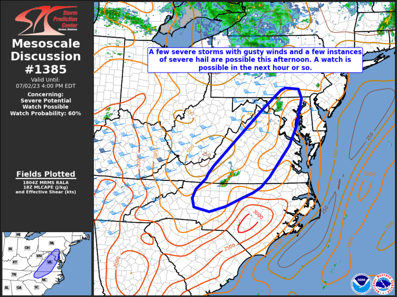
Mesoscale Discussion 1385
NWS Storm Prediction Center Norman OK
0223 PM CDT Sun Jun 23 2024

Areas affected...Portions of eastern PA...southeast NY...northwest
NJ...CT...and southern MA

Concerning...Severe potential...Watch possible

Valid 231923Z - 232130Z

Probability of Watch Issuance...40 percent

SUMMARY...The area is being monitored for a few strong to severe
storms this afternoon. Damaging winds and perhaps a tornado or two
appear to be the main concerns. Convective and environmental trends
are being monitored for a possible watch for parts of the area.

DISCUSSION...Strong diurnal heating within cloud breaks from eastern
PA northeastward across southern New England is supporting steep
low-level lapse rates amid lower 70s boundary-layer dewpoints. While
large-scale ascent is generally weak across the area, convection
approaching from the west and potentially new development along
mesoscale/differential heating boundaries could become strong to
severe, given 40 kt of deep-layer shear per regional VWP. Ample
low/midlevel flow and the steepened low-level lapse rates will favor
a damaging-wind risk, and sufficient low-level hodograph curvature
could support a brief tornado or two with any sustained supercell
structures. Overall, confidence in the development of persistent
strong/severe updrafts is low owing to the weak forcing for ascent,
though convective and environmental trends are being monitored for a
possible watch this afternoon.

..Weinman/Hart.. 06/23/2024

...Please see www.spc.noaa.gov for graphic product...

ATTN...WFO...BOX...OKX...ALY...PHI...BGM...CTP...

LAT...LON   40567764 41927651 42667570 42767522 42707460 42197261
            42117118 41827107 41617114 41417205 41337260 41267332
            40707473 40077557 39857619 39887700 40157759 40567764
https://www.spc.noaa.gov/products/md/md1385.html
date: 2024-06-23, from: NOAA tornado/severe thunderstorm watches, mesoscale discussions, convective outlooks, fire weather outlooks

Mesoscale Discussion 1384
NWS Storm Prediction Center Norman OK
0137 PM CDT Sun Jun 23 2024

Areas affected...eastern New York...Vermont...and western New
Hampshire.

Concerning...Tornado Watch 448...

Valid 231837Z - 232000Z

The severe weather threat for Tornado Watch 448 continues.

SUMMARY...Storms forming across eastern New York into north-central
Vermont  have the greatest severe weather potential over the next 1
to 2 hours.

DISCUSSION...Storms have developed from eastern New York to
north-central Vermont. These storms have developed within a locally
more favorable environment featuring southerly surface winds and
temperatures in the mid 80s with dewpoints in the low to mid 70s. In
close proximity to the eastward/northeastward advancing warm front
and in terrain favored locations where more backed winds can remain,
a greater tornado threat may exist through the afternoon.

..Bentley.. 06/23/2024

...Please see www.spc.noaa.gov for graphic product...

ATTN...WFO...GYX...BOX...BTV...ALY...

LAT...LON   42557422 43777374 44557306 44707245 44757180 43747171
            42517196 42197322 42177383 42557422
https://www.spc.noaa.gov/products/md/md1384.html
date: 2024-06-23, from: NOAA tornado/severe thunderstorm watches, mesoscale discussions, convective outlooks, fire weather outlooks

Mesoscale Discussion 1383
NWS Storm Prediction Center Norman OK
1242 PM CDT Sun Jun 23 2024

Areas affected...Portions of the Ohio River Valley into southern New
York

Concerning...Severe potential...Watch likely

Valid 231742Z - 231945Z

Probability of Watch Issuance...80 percent

SUMMARY...Severe storm risk will gradually increase through the
afternoon, with damaging winds being the primary concern. A watch
will likely be issued for parts of the area in the next few hours.

DISCUSSION...Ahead of a northeast/southwest-oriented cold front
draped across the OH River Valley, a corridor of upper 60s to lower
70s dewpoints and pockets of heating will contribute to moderate
surface-based instability -- despite poor midlevel lapse rates
sampled by 12Z observed soundings. As modest midlevel height falls
overspread the region, surface-based thunderstorms should gradually
increase in coverage along/ahead of the cold front.

Storms should slowly increase in intensity as they track eastward
and intercept the destabilizing warm/moist sector. Given ample
deep-layer westerly flow/shear (around 35-kt effective shear)
roughly perpendicular to the front, a mix of loosely organized
clusters and transient supercells are expected. Steepening low-level
lapse rates and the enhanced low/midlevel flow will favor locally
damaging gusts as the primary concern, especially with any localized
upscale growth. However, marginally severe hail and a tornado or two
cannot be ruled out, especially with any sustained semi-discrete
supercells. A watch (potentially two separate watches) will likely
be issued for parts of the area in the next few hours.

..Weinman/Hart.. 06/23/2024

...Please see www.spc.noaa.gov for graphic product...

ATTN...WFO...BGM...BUF...CTP...LWX...PBZ...RLX...CLE...JKL...
ILN...LMK...

LAT...LON   40268200 41078095 41647995 42107886 42557771 42607687
            42437624 42137602 41737607 40937729 40347822 39857898
            39158017 38068234 37938362 38138434 38578444 39018438
            39378380 39738286 40268200
https://www.spc.noaa.gov/products/md/md1383.html
date: 2024-06-23, from: NOAA Weather Forecasts

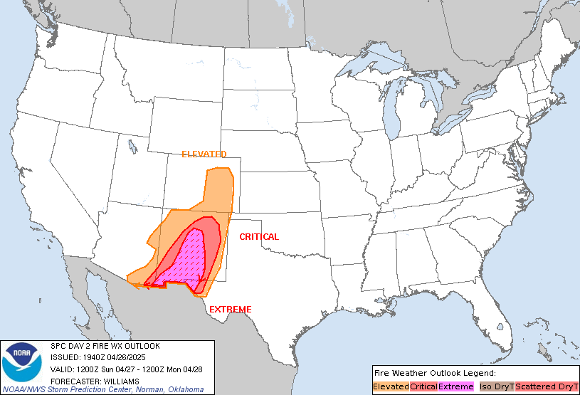
Day 2 Fire Weather Outlook
NWS Storm Prediction Center Norman OK
0200 PM CDT Sun Jun 23 2024

Valid 241200Z - 251200Z

The previous forecast remains on track with only minor adjustments
made based on recent trends in guidance. Ensemble solutions continue
to suggest low probability for critical fire weather conditions, but
reasonably high potential for elevated conditions within the
highlighted regions. See the previous discussion for additional
details.

..Moore.. 06/23/2024

.PREV DISCUSSION... /ISSUED 0125 AM CDT Sun Jun 23 2024/

...Synopsis...
The upper-level trough in the Northwest will move into the northern
Rockies and Plains through the day on Monday. A surface front will
have moved through the Northwest and stalled in the northern Great
Basin.

Surface winds from the lee of the northern Sierra into the Snake
River Plain will be modestly enhanced ahead of the front.
Furthermore, lingering stronger mid-level winds will remain across
southern Idaho. These features will promote dry and breezy
conditions during the afternoon. RH of 10-20% will be possible.
Winds of 15-20 mph can be expected, though speeds approaching 25 mph
may occur in the Snake River Plain. Elevated fire weather is
expected in these areas for a few hours during the afternoon.
Locally critical is again possible in the Snake Plain, but fuels
will continue to mitigate greater risk.

...Please see www.spc.noaa.gov/fire for graphic product...
https://www.spc.noaa.gov/products/fire_wx/fwdy2.html
date: 2024-06-23, from: Eastern Pacific Basin GIS Data
No tropical cyclones as of Sun, 23 Jun 2024 17:35:38 GMT
date: 2024-06-23, from: Central Pacific Tropical Weather Outlook
000
ACPN50 PHFO 231735
TWOCP
Tropical Weather Outlook
NWS Central Pacific Hurricane Center
Honolulu HI
800 AM HST Sun Jun 23 2024
For the
central North Pacific…between 140W and 180W:
No tropical
cyclones are expected during the next 7 days.
$$
Forecaster JVC
https://www.nhc.noaa.gov/gtwo.php?basin=cpac
date: 2024-06-23, from: Central Pacific Basin Tropical Cyclones
No tropical cyclones as of Sun, 23 Jun 2024 17:35:38 GMT
date: 2024-06-23, from: NOAA tornado/severe thunderstorm watches, mesoscale discussions, convective outlooks, fire weather outlooks

Day 2 Convective Outlook
NWS Storm Prediction Center Norman OK
1230 PM CDT Sun Jun 23 2024

Valid 241200Z - 251200Z

...THERE IS A SLIGHT RISK OF SEVERE THUNDERSTORMS IN PARTS OF THE
UPPER MIDWEST...

...SUMMARY...
Scattered severe thunderstorms will be possible over parts of the
Upper Midwest, mainly from late afternoon Monday into Monday night.
A low-probability scenario of a severe MCS producing destructive
wind gusts is apparent, centered on central parts of Minnesota into
Wisconsin.

...Upper Midwest...
Confidence in tomorrow's severe evolution is low. A wide range in
potential outcomes from a sporadic primarily elevated large hail
threat to a derecho scenario are plausible. Primary change with this
outlook is to add a significant severe wind area for the conditional
potential of destructive wind gusts from an intense MCS.

A shortwave trough should amplify somewhat over the southern Prairie
Provinces, mainly during the latter portion of the period. This will
induce weak mid-level height falls by Monday evening/night across
northern portions of the Upper Midwest. Primary surface cyclone will
similarly track east from southeast SK to far northwest ON. A
north/south-oriented cold front attendant to this cyclone should
push east across the northern Great Plains, with the trailing
portion slowing and eventually stalling near the SD/NE border area.

A very stout EML characterized by 700-mb temperatures of 14-16 C
will inhibit surface-based warm sector development through much of
the day, with remnant elevated convection from late D1 over ND
potentially persisting on an isolated basis along the periphery of
the EML, mainly over northern MN. Large to extreme buoyancy will
develop, centered on eastern SD into western MN, with MLCAPE in
excess of 4000 J/kg probable.

Isolated late-afternoon to early-evening storm development will be
possible near the cold front over eastern ND into
west-central/northwest MN. Guidance differs greatly on whether this
will occur or not given the stout capping to the southeast. A more
probable scenario is for elevated convection to develop during the
evening into the overnight as a low-level jet intensifies from the
Mid-MO Valley towards Lake Superior. Guidance also differs on the
evolution of the surface warm front into Monday evening/night with
the 12Z NAM holding farther south and more pronounced with the
baroclinic zone across central MN. Most other guidance advances the
warm front deeper into northern MN. Given these spatial concerns
along with the relatively weak forcing for ascent near/just after
peak heating amid pronounced capping over the open warm sector,
confidence is low in the most likely scenario of convective
evolution. Isolated, very large hail will be possible given
plentiful elevated MUCAPE and strengthening effective bulk shear.
The 12Z HRW-ARW depicts a more ominous scenario with surface-based
development over the Upper Red River Valley growing upscale into an
intense, bowing MCS through central portions of MN/WI. This includes
a signal for extreme rear-inflow jet development to around 95 kts at
the mature stage over west-central WI. Other guidance suggests a
later MCS may develop out of the elevated convection in north parts
of MN/WI, and still other guidance suggests little, if any MCS
development will occur. The decision has been made to defer on a
categorical upgrade and await potentially more consistent guidance
in later outlook cycles.

...Black Hills vicinity into parts of NE and western IA...
The southern portion of the weak cold front should slow and stall
near the SD/NE border area by early evening Monday. Strong heating
in the vicinity of the boundary will support isolated to widely
scattered high-based thunderstorm development. With generally weak
mid-level flow across the region, storms may quickly become outflow
dominant, but steep tropospheric lapse rates will support at least
isolated severe gusts. The strongest updrafts may also be capable of
producing some hail.

...Coastal Carolinas...
A cold front is forecast to move across the coastal Carolinas
vicinity, with scattered thunderstorm development expected during
the afternoon. Moderate to locally strong prefrontal buoyancy (with
MLCAPE of near/above 2000 J/kg) and effective shear generally around
25-30 kt will support potential for a few stronger multicells and
perhaps a marginal supercell or two, with an attendant threat of
locally damaging winds and hail.

..Grams.. 06/23/2024
https://www.spc.noaa.gov/products/outlook/day2otlk_1730.html
date: 2024-06-23, from: Graphical Tropical Weather Outlooks


https://www.nhc.noaa.gov/gtwo.php?basin=atlc
date: 2024-06-23, from: Eastern Pacific Tropical Weather Outlook
000
ABPZ20 KNHC 231710
TWOEP
Tropical Weather Outlook
NWS National Hurricane Center Miami
FL
1100 AM PDT Sun Jun 23 2024
For the eastern North
Pacific…east of 140 degrees west longitude:
Tropical
cyclone formation is not expected during the next 7 days.
$$
Forecaster Pasch
https://www.nhc.noaa.gov/gtwo.php?basin=epac
date: 2024-06-23, from: NOAA tornado/severe thunderstorm watches, mesoscale discussions, convective outlooks, fire weather outlooks

STATUS FOR WATCH 0448 HAS NOT BEEN ISSUED YET
https://www.spc.noaa.gov/products/watch/ws0448.html
date: 2024-06-23, from: NOAA tornado/severe thunderstorm watches, mesoscale discussions, convective outlooks, fire weather outlooks

URGENT - IMMEDIATE BROADCAST REQUESTED
Tornado Watch Number 448
NWS Storm Prediction Center Norman OK
100 PM EDT Sun Jun 23 2024

The NWS Storm Prediction Center has issued a

* Tornado Watch for portions of
  Massachusetts
  Western Maine
  New Hampshire
  Northeast New York
  Vermont

* Effective this Sunday afternoon and evening from 100 PM until
  800 PM EDT.

* Primary threats include...
  A few tornadoes likely
  Scattered damaging wind gusts to 70 mph likely
  Scattered large hail events to 1.5 inches in diameter possible

SUMMARY...Thunderstorms will develop this afternoon across eastern
New York and track eastward across the watch area through the day.
Supercells capable of damaging winds, hail, and a few tornadoes are
expected.

The tornado watch area is approximately along and 85 statute miles
north and south of a line from 65 miles southwest of Saranac Lake NY
to 25 miles south southeast of Augusta ME. For a complete depiction
of the watch see the associated watch outline update (WOUS64 KWNS
WOU8).

PRECAUTIONARY/PREPAREDNESS ACTIONS...

REMEMBER...A Tornado Watch means conditions are favorable for
tornadoes and severe thunderstorms in and close to the watch
area. Persons in these areas should be on the lookout for
threatening weather conditions and listen for later statements
and possible warnings.

&&

AVIATION...Tornadoes and a few severe thunderstorms with hail
surface and aloft to 1.5 inches. Extreme turbulence and surface wind
gusts to 60 knots. A few cumulonimbi with maximum tops to 500. Mean
storm motion vector 26030.

...Hart
https://www.spc.noaa.gov/products/watch/ww0448.html
date: 2024-06-23, from: NOAA Weather Forecasts

Day 1 Fire Weather Outlook
NWS Storm Prediction Center Norman OK
1117 AM CDT Sun Jun 23 2024

Valid 231700Z - 241200Z

The previous forecast generally remains on track with only minor
adjustments made to reflect recent fire reports, morning surface
observations, and trends in latest high-res guidance. A dry frontal
passage is underway across the Pacific Northwest as mid-level winds
increase over the central Cascades (based on the evolution of
high-level cirrus over the region). Surface pressure falls in the
lee of the Cascades/northern Sierra Nevada should become more
apparent in the coming hours with an attendant increase in surface
winds. Latest guidance suggests the onset of elevated fire weather
conditions will be around 18 UTC along/east of the Sierra Nevada and
Cascades with a slightly later onset for the Snake River Plain.
Localized critical conditions also remain possible through the
Columbia Gorge and along the NV/OR border; however, higher RH with
northward extent and displacement from the stronger mid-level flow
with southern extent continue to limit confidence in the
coverage/duration of critical conditions.

..Moore.. 06/23/2024

.PREV DISCUSSION... /ISSUED 0124 AM CDT Sun Jun 23 2024/

...Synopsis...
An upper-level trough will move through parts of the Northwest
today, favorably timed with peak heating. Surface low pressure will
deepen in the lee of the northern and Canadian Rockies. Surface
winds will increase across the region and into the northern Great
Basin.

...Columbia Basin...
Winds of 15-20 mph (higher downwind of the Cascade Gaps) are
expected by the afternoon. RH may only lower to around 20% in many
places due to at least some push of marine air across the Cascades.
Given the relatively dry fuels and the expected winds, elevated fire
weather is possible.

...OR/NV/CA...
Temperatures will be warmer and RH lower farther south. RH could
fall to near 10-15% over a broad area. Winds away from the mid-level
jet will be slightly weaker, but 15-20 mph is still possible,
especially near terrain features. With dry fuels in these areas,
fire weather concerns will be elevated.

...Snake River Plain...
The southern periphery of the mid-level jet will sag into southern
Idaho. This, combined with the strengthening surface pressure
gradient, will promote 15-25 mph winds within the valley. RH of
15-20% appears probable. Duration of potentially critical conditions
will be minimal and fuels are not yet critically dry. That said,
elevated to locally critical fire weather is expected during the
afternoon.

...Please see www.spc.noaa.gov/fire for graphic product...
https://www.spc.noaa.gov/products/fire_wx/fwdy1.html
date: 2024-06-23, from: NOAA tornado/severe thunderstorm watches, mesoscale discussions, convective outlooks, fire weather outlooks

Day 1 Convective Outlook
NWS Storm Prediction Center Norman OK
1113 AM CDT Sun Jun 23 2024

Valid 231630Z - 241200Z

...THERE IS AN ENHANCED RISK OF SEVERE THUNDERSTORMS THIS AFTERNOON
ACROSS PORTIONS OF EASTERN NEW YORK...VERMONT...NEW
HAMPSHIRE...MASSACHUSETTS...AND WESTERN MAINE....

...THERE IS A SLIGHT RISK OF SEVERE THUNDERSTORMS THIS EVENING OVER
PARTS OF NORTHEAST MONTANA AND NORTHWEST NORTH DAKOTA...

...SUMMARY...
Scattered damaging winds and a few tornadoes are likely across parts
of the Northeast and New England, with additional severe storms
expected across the Ohio Valley, Mid-Atlantic region, as well as the
Northern High Plains.

...New England...
Visible satellite imagery shows broken clouds across central/eastern
NY and parts of southern/western New England, where dewpoints are in
the upper 60s to lower 70s.  This is resulting in rapid
destabilization of the air mass, with a corridor of ~2000 J/kg and
little inhibition.  This should lead to scattered thunderstorm
development early this afternoon over central/eastern NY, tracking
rapidly eastward into VT/NH and northern MA.  Forecast soundings
show substantial vertical shear in this region, as storms develop
beneath the mid-level jet axis.  A remnant surface boundary
currently extends from northeast VT into northeast MA.  As storms
interact with this boundary, locally enhanced low-level shear may
result in a more focused risk for a few tornadoes.  Otherwise,
damaging wind gusts and some hail are the main threats.

...Upper OH Valley...
An axis of warm/humid conditions is present today from KY
northeastward into western PA, where temperatures will warm through
the 80s with dewpoints in the lower 70s.  Model guidance suggests at
least widely scattered afternoon thunderstorms will form.
Relatively steep low level lapse rates, significant water-loaded
downdrafts, and favorably strong low/mid level wind fields will pose
a risk of locally damaging wind gusts in the stronger cells through
the afternoon and early evening.

...MT/ND...
Model guidance continues to show the potential for a supercell storm
or two to form over southern Manitoba and track near/across the
international border, affecting parts of northeast MT and northwest
ND tonight - mainly after dark.  Sufficient CAPE/shear parameters
would support a risk of large hail in these storms.

..Hart/Weinman.. 06/23/2024
https://www.spc.noaa.gov/products/outlook/day1otlk_1630.html