(date: 2024-07-19 07:54:33)
date: 2024-07-19, from: NOAA tornado/severe thunderstorm watches, mesoscale discussions, convective outlooks, fire weather outlooks
No watches are valid as of Fri Jul 19 13:53:02 UTC 2024.
https://www.spc.noaa.gov/products/watch/
date: 2024-07-19, from: NOAA tornado/severe thunderstorm watches, mesoscale discussions, convective outlooks, fire weather outlooks
No Mesoscale Discussions are in effect as of Fri Jul 19 13:53:02 UTC 2024.
https://www.spc.noaa.gov/products/md/
date: 2024-07-19, from: NOAA tornado/severe thunderstorm watches, mesoscale discussions, convective outlooks, fire weather outlooks

Day 1 Convective Outlook
NWS Storm Prediction Center Norman OK
0753 AM CDT Fri Jul 19 2024

Valid 191300Z - 201200Z

...THERE IS AN ENHANCED RISK OF SEVERE THUNDERSTORMS FROM PARTS OF
SOUTHWESTERN/SOUTH-CENTRAL NEBRASKA ACROSS WESTERN KANSAS AND
EXTREME EASTERN COLORADO...

...SUMMARY...
The most favorable corridor for damaging thunderstorm gusts (some
potentially exceeding 70 mph) will be late this afternoon and
evening from parts of southwestern/south-central Nebraska across
western Kansas and extreme eastern Colorado.

...Synopsis...
A large anticyclone in mid/upper levels -- initially centered over
north-central/northeastern AZ -- is forecast to retrograde
northwestward over more of the Great Basin today.  This will result
in northwesterly flow over the northern Great Plains, and
substantially northerly mid/upper flow over most of the rest of the
Plains States, in conjunction with the persistent eastern CONUS
longwave trough.  Within that regime, a shortwave trough now located
over eastern MT is expected to move southeastward to southern SD and
northern NE by 00Z.  Overnight, this feature may phase with another,
weaker trough to its east, as well as take on convectively generated
vorticity, and move over eastern NE/IA and vicinity.

At the surface, a weak, slow-moving frontal zone (cold or warm on
various mesoscale segments) was analyzed at 11Z from the Hampton
Roads area across northern parts of GA/AL/MS/LA, becoming diffuse
over central/north TX.  Richest maritime/tropical moisture was (and
will remain) confined along and south of that boundary through the
period.  However, a corridor of relatively maximized moisture, with
dewpoints upper 50s to low 60s F -- was analyzed from the central
Dakotas to western/central NE and western KS, with some eastward
shifting/erosion possible on the west side today as heating/mixing
occur.  A lee trough should remain over the High Plains from eastern
MT to the western NE Panhandle and eastern CO, to eastern NM.  A
trough now over parts of central SD into northwestern NE, to a low
at the intersection of the troughs near BFF, potentially will become
better defined and shifting southeast amid mass response to the
approaching perturbation aloft.

...Central/southern Great Plains...
Isolated to scattered thunderstorms are expected to develop this
afternoon over both the Front Range/Foothills corridor of CO and
southeastern WY, and near a surface trough across northern/central
NE.  Damaging gusts and large hail will be possible with early-stage
activity over NE, with gusts the more probable hazard in the CO
convection.  Activity should evolve upscale in both areas, moving
southeastward over CO and generally southward with some westward
backbuilding over central NE to western KS.  An MCS with organizing
cold pool appears increasingly probable, with one or more associated
swaths of severe gusts expected.

The best-organized and most-intense severe-wind potential may begin
sooner and farther north, and conditionally may persist farther
south before overnight weakening, than depicted in the "enhanced"/
30%-wind area.  However, a preponderance of guidance -- reasonably,
given the overall pattern and placement of the moisture/instability
corridor -- has settled on the area from southwestern NE southward
across western KS to near the OK Panhandle as a most-probable
corridor for severe gusts.  At least isolated significant-severe
(65+ kt) gusts also may be observed.

Enough vertical shear will be present to support supercell potential
with any relatively discrete convection in the early stages, as
strong veering with height contributes to 30-45-kt effective-shear
magnitudes, despite lacking stronger midlevel winds.  Activity over
CO will be in weaker (but still sufficient) low-level moisture and
higher-based.  However, even near the moist axis over central NE and
western KS, a deeply well-mixed boundary layer will support wind
potential.  Strong surface heating should help to boost MLCAPE to
2000-2500 J/kg over much of central/west-central NE, and 1500-2000
J/kg over western KS.  Activity moving into eastern NE into central
KS will encounter weaker instability and greater CINH, limiting
eastward extent of the severe threat, while nocturnal cooling and
related stabilization will decrease the threat southward into
northwestern OK and the Panhandles.  How far the severe-gust threat
penetrates into that stabilizing air will depend largely on strength
of cold-pool-driven forced ascent and associated downdraft
production, driven by low-predictability internal dynamics of the
complex.

..Edwards/Broyles.. 07/19/2024
https://www.spc.noaa.gov/products/outlook/day1otlk_1300.html
date: 2024-07-19, from: Eastern Pacific Basin GIS Data
No tropical cyclones as of Fri, 19 Jul 2024 11:31:57 GMT
date: 2024-07-19, from: Eastern Pacific Basin Tropical Cyclones
000
ABPZ20 KNHC 191130
TWOEP
Tropical
Weather Outlook
NWS National Hurricane Center Miami FL
500 AM
PDT Fri Jul 19 2024
For the eastern North Pacific…east of 140
degrees west longitude:
South of Southern Mexico:
An
area of low pressure could form by early next week a few hundred
miles south of the coast of southern Mexico. Thereafter, some slow
development of this system is possible through the latter part of
next week while it moves westward to west-northwestward at 10 to 15
mph.
* Formation chance through 48 hours…low…near 0
percent.
* Formation chance through 7 days…low…20 percent.
$$
Forecaster Reinhart
https://www.nhc.noaa.gov/gtwo.php?basin=epac
date: 2024-07-19, from: Central Pacific Basin Tropical Cyclones
425
ACPN50 PHFO 191121
TWOCP
Tropical
Weather Outlook
NWS Central Pacific Hurricane Center Honolulu
HI
200 AM HST Fri Jul 19 2024
For the central North
Pacific…between 140W and 180W:
No tropical cyclones are
expected during the next 7 days.
$$
Forecaster
Bohlin
https://www.nhc.noaa.gov/gtwo.php?basin=cpac
date: 2024-07-19, from: Central Pacific Basin Tropical Cyclones
No tropical cyclones as of Fri, 19 Jul 2024 11:31:57 GMT
date: 2024-07-19, from: Graphical Tropical Weather Outlooks
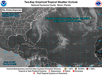
https://www.nhc.noaa.gov/gtwo.php?basin=atlc
date: 2024-07-19, from: NOAA Weather Forecasts
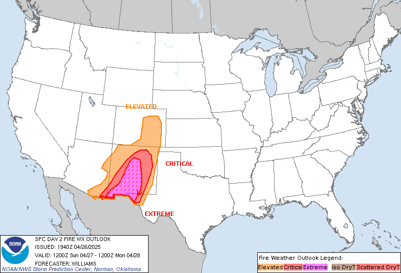
Day 2 Fire Weather Outlook
NWS Storm Prediction Center Norman OK
0205 AM CDT Fri Jul 19 2024

Valid 201200Z - 211200Z

...Synopsis...
An upper ridge over the western Rockies will persist D2/Saturday as
a broad Pacific trough moves onshore over the Northwest. To the
east, northwesterly flow aloft will continue over the northern
Rockies and Intermountain west, with seasonable monsoon moisture.
Widely scattered thunderstorms appear likely through the afternoon
with a risk for lightning within dry fuels.

...Northwest into the Great Basin and northern Rockies...
With the approach of the West Coast trough, weak ascent will allow
for isolated thunderstorm development along the higher terrain of
the Sierra and Cascades by early afternoon. Initial PWAT values of
0.8 to 1 inches will favor drier storm over areas of significantly
dry fuels and recent fire activity.

Storm coverage may increase overnight as the upper trough continues
onshore and ascent increases. While PWATs should also increase above
1 inch with onshore flow, faster storm motions will tend to limit
wetting rainfall, favoring drier storms. While confidence in
convective evolution toward the end of the period is lower, some
guidance suggests the largest increase in storm coverage after dark
may be focused west of the Cascades toward the coastal ranges of OR
and northern CA.

Farther east into the Great Basin and northern Rockies, confidence
in dry storms is somewhat lower. Flow aloft along the eastern
periphery of the ridge will be weaker with deeper monsoonal moisture
in place. The combination of slower storm speeds and higher PWATs
suggests storms may have greater rainfall efficiency. Still, the
potential for lighting outside of the wetter cores from scattered
storm coverage, and the possibility of a few drier storms, suggest
some threat for lightning ignitions within mostly receptive fuels.

..Lyons.. 07/19/2024

...Please see www.spc.noaa.gov/fire for graphic product...
https://www.spc.noaa.gov/products/fire_wx/fwdy2.html
date: 2024-07-16, from: NOAA tornado/severe thunderstorm watches, mesoscale discussions, convective outlooks, fire weather outlooks

Mesoscale Discussion 1657
NWS Storm Prediction Center Norman OK
0349 PM CDT Tue Jul 16 2024

Areas affected...Southeast CO...northeast NM...southwest KS...TX/OK
Panhandles

Concerning...Severe potential...Watch possible

Valid 162049Z - 162245Z

Probability of Watch Issuance...40 percent

SUMMARY...Some increase in the severe-wind and isolated hail threat
is possible through late afternoon into early evening.

DISCUSSION...Convection developing near the higher terrain of
south-central CO into northeast NM has gradually intensified this
afternoon, with a recent measured gust of 51 kt at Colorado Springs.
Farther east, storms are beginning to develop across parts of
southeast CO into the Raton Mesa vicinity. Low-level moisture is
generally rather modest across the region, but strong heating has
resulted in MLCAPE increasing to 500-1000 J/kg, with some further
increase possible into late afternoon. Modest northwesterly midlevel
flow along the periphery of an upper ridge over the southern Rockies
is supporting effective shear of 25-35 kt, which may support
occasional storm organization.

Initial discrete storms will continue to pose a threat of isolated
severe gusts and possibly some hail. With time, increasingly
prominent outflow within the initially hot and well-mixed
environment will support development of one or more loosely
organized clusters, which would move southeastward with some
increase in the severe-wind threat into parts of the
central/southern High Plains. Watch issuance is possible over parts
of the region, if a more organized severe threat appears imminent.

..Dean/Hart.. 07/16/2024

...Please see www.spc.noaa.gov for graphic product...

ATTN...WFO...DDC...GLD...AMA...PUB...BOU...ABQ...

LAT...LON   38670512 38800169 37820065 36470076 35000080 34950082
            34860235 35000350 36140432 37070460 38670512
https://www.spc.noaa.gov/products/md/md1657.html
date: 2024-07-16, from: NOAA tornado/severe thunderstorm watches, mesoscale discussions, convective outlooks, fire weather outlooks

Mesoscale Discussion 1656
NWS Storm Prediction Center Norman OK
0300 PM CDT Tue Jul 16 2024

Areas affected...Central and Eastern New York into Vermont

Concerning...Severe Thunderstorm Watch 546...547...

Valid 162000Z - 162130Z

The severe weather threat for Severe Thunderstorm Watch 546, 547
continues.

SUMMARY...The severe weather threat continues for WW 547, with
measured wind gusts of 65+ MPH and a few tornadoes possible.

DISCUSSION...The severe weather threat continues for Central and
Eastern New York this afternoon, as an ongoing linear convective
complex moves across the highlight area. Measured wind gusts of 65+
MPH have already been observed, in addition to tornadoes. This
convective activity is expected to persist over the next few hours
as it moves eastward into Vermont.

There is a localized corridor of enhanced tornado potential in the
center of the convective line, where low-level convective
organization and rotation is concentrated in a favorable environment
of STP > 1. Multiple embedded circulations have been observed
already, and will likely persist in the storm term.

..Halbert/Squitieri.. 07/16/2024

...Please see www.spc.noaa.gov for graphic product...

ATTN...WFO...BOX...BTV...ALY...BGM...BUF...

LAT...LON   42187437 42217488 42407533 42607549 42887543 43177542
            43457541 43807531 44147517 44417496 44667430 44757352
            44707293 44497247 44207225 43777233 43187258 42847283
            42537308 42177363 42187437
https://www.spc.noaa.gov/products/md/md1656.html
date: 2024-07-16, from: NOAA tornado/severe thunderstorm watches, mesoscale discussions, convective outlooks, fire weather outlooks

Mesoscale Discussion 1655
NWS Storm Prediction Center Norman OK
0240 PM CDT Tue Jul 16 2024

Areas affected...Central NE into parts of north-central KS and
south-central SD

Concerning...Severe potential...Watch possible

Valid 161940Z - 162145Z

Probability of Watch Issuance...40 percent

SUMMARY...Strong to severe storms may develop by late afternoon.

DISCUSSION...Cumulus is deepening this afternoon across parts of
south-central NE, with some building cumulus also noted into
northwest NE and extreme south-central SD. The building cumulus is
ongoing within a region of relatively rich low-level moisture, with
diurnal heating supporting MLCAPE of near/above 1500 J/kg and
weakening MLCINH. In the absence of stronger large-scale ascent,
details regarding storm coverage and timing of more robust storm
development remain uncertain. However, storm initiation is underway
across south-central NE, with at least isolated development possible
farther north, within a zone of modest low-level confluence near a
weak surface low across central NE.

Low-level flow is weak, but modest midlevel west-northwesterlies are
supporting effective shear of 30-40 kt, and it is possible that a
couple of supercells and/or stronger storm clusters could develop by
late afternoon into the early evening. Midlevel lapse rates are
generally rather weak, but some hail threat could accompany any
sustained supercells, along with a threat of localized severe gusts.
Watch issuance is possible for parts of the area later this
afternoon, if development of multiple severe storms appears
imminent.

..Dean/Hart.. 07/16/2024

...Please see www.spc.noaa.gov for graphic product...

ATTN...WFO...FSD...OAX...TOP...ICT...GID...LBF...DDC...UNR...
GLD...

LAT...LON   43360030 42929853 41749728 40919720 40199716 39469763
            39079809 39019974 38990054 39130096 39460102 40020109
            40430109 42250183 43170172 43360030
https://www.spc.noaa.gov/products/md/md1655.html
date: 2024-07-16, from: NOAA tornado/severe thunderstorm watches, mesoscale discussions, convective outlooks, fire weather outlooks
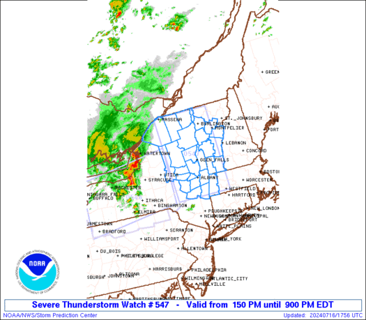
STATUS REPORT ON WW 547

THE SEVERE WEATHER THREAT CONTINUES ACROSS THE ENTIRE WATCH AREA.

FOR ADDITIONAL INFORMATION SEE MESOSCALE DISCUSSION 1656

..HALBERT..07/16/24

ATTN...WFO...ALY...BTV...


STATUS REPORT FOR WS 547

SEVERE WEATHER THREAT CONTINUES FOR THE FOLLOWING AREAS

MAC003-162140-

MA
.    MASSACHUSETTS COUNTIES INCLUDED ARE

BERKSHIRE


NYC001-019-021-031-033-035-039-041-043-057-083-089-091-093-095-
113-115-162140-

NY
.    NEW YORK COUNTIES INCLUDED ARE

ALBANY               CLINTON             COLUMBIA
ESSEX                FRANKLIN            FULTON
GREENE               HAMILTON            HERKIMER
MONTGOMERY           RENSSELAER          ST. LAWRENCE
SARATOGA             SCHENECTADY         SCHOHARIE
WARREN               WASHINGTON


VTC001-003-007-013-017-021-023-025-027-162140-
https://www.spc.noaa.gov/products/watch/ws0547.html
date: 2024-07-16, from: NOAA tornado/severe thunderstorm watches, mesoscale discussions, convective outlooks, fire weather outlooks

URGENT - IMMEDIATE BROADCAST REQUESTED
Severe Thunderstorm Watch Number 547
NWS Storm Prediction Center Norman OK
150 PM EDT Tue Jul 16 2024

The NWS Storm Prediction Center has issued a

* Severe Thunderstorm Watch for portions of
  Western Massachusetts
  Eastern New York
  Central and Southern Vermont

* Effective this Tuesday afternoon and evening from 150 PM until
  900 PM EDT.

* Primary threats include...
  Scattered damaging winds likely with isolated significant gusts
    to 75 mph possible
  Isolated large hail events to 1.5 inches in diameter possible
  A tornado or two possible

SUMMARY...Thunderstorms over central New York will track quickly
eastward across the watch area this afternoon, posing a risk of
damaging winds.

The severe thunderstorm watch area is approximately along and 60
statute miles east and west of a line from 45 miles north northeast
of Saranac Lake NY to 30 miles southwest of Pittsfield MA. For a
complete depiction of the watch see the associated watch outline
update (WOUS64 KWNS WOU7).

PRECAUTIONARY/PREPAREDNESS ACTIONS...

REMEMBER...A Severe Thunderstorm Watch means conditions are
favorable for severe thunderstorms in and close to the watch area.
Persons in these areas should be on the lookout for threatening
weather conditions and listen for later statements and possible
warnings. Severe thunderstorms can and occasionally do produce
tornadoes.

&&

OTHER WATCH INFORMATION...CONTINUE...WW 546...

AVIATION...A few severe thunderstorms with hail surface and aloft to
1.5 inches. Extreme turbulence and surface wind gusts to 65 knots. A
few cumulonimbi with maximum tops to 500. Mean storm motion vector
27030.

...Hart
https://www.spc.noaa.gov/products/watch/ww0547.html
date: 2024-07-16, from: NOAA tornado/severe thunderstorm watches, mesoscale discussions, convective outlooks, fire weather outlooks

Day 1 Convective Outlook
NWS Storm Prediction Center Norman OK
0257 PM CDT Tue Jul 16 2024

Valid 162000Z - 171200Z

...THERE IS AN ENHANCED RISK OF SEVERE THUNDERSTORMS PORTIONS OF
EASTERN NEW YORK INTO SOUTHERN VERMONT...

...THERE IS A SLIGHT RISK OF SEVERE THUNDERSTORMS ACROSS
CENTRAL/EASTERN NEBRASKA...SOUTHEAST COLORADO INTO NORTHWEST
OKLAHOMA...SOUTHERN MISSOURI INTO WESTERN KENTUCKY...

...SUMMARY...
Strong to severe thunderstorms are possible from the central Plains
to the Northeast.  Greatest severe-thunderstorm threats within that
are over parts of the central Plains and upper Ohio Valley to parts
of the northern Mid-Atlantic and western New England.

...20Z Update...
Severe probabilities have been adjusted behind ongoing convection
and the mid-level shortwave in parts of New York and Pennsylvania.
Elsewhere, the outlook remains mostly on track with only minor
adjustments based on current observations and expected convective
evolution.

..Wendt.. 07/16/2024

.PREV DISCUSSION... /ISSUED 1128 AM CDT Tue Jul 16 2024/

...Northeast States...
A well-defined shortwave trough and embedded MCV from last night's
severe MCS is tracking into western NY.  Strong heating of a moist
air mass ahead of this system will result in intensification of
thunderstorms early this afternoon, with storms tracking eastward
across NY/northern PA into New England this evening.  Damaging winds
(potentially widespread) will be the main concern with these storms,
although hail and a tornado or two are also possible.  Have expanded
the SLGT risk to the MA/NH coast, given favorable westerly surface
winds and morning CAM solutions suggesting that MCS may persist that
far.

South of the main upper feature, a hot and humid air mass is present
from central PA and NJ southward.  Widely scattered afternoon
thunderstorms will develop in this area, despite rather weak
forcing.  Sufficient winds aloft will promote a few organized storm
clusters, capable of damaging wind gusts.

...CO/KS/OK/TX...
Full sunshine will lead to very deep boundary-layer mixing and
scattered high-based showers/thunderstorms along the Colorado Front
Range this afternoon.  This activity will be capable of locally
gusty/damaging winds.  As the convection spread east-southeastward
into a progressively more moist air mass, intensification and
organization of storms into an MCS is expected.  This system will
track into southwest KS and northwest OK this evening, with a
continued risk of locally damaging wind gusts.

...Central NE...
A surface cold front is sagging southward across SD/NE today.
Thunderstorms are expected to intensify along this front over
central NE late this afternoon or early evening.  Activity will
track southward for a few hours, posing a risk of damaging wind
gusts.

...Mid MS Valley...
A large and persistent area of thunderstorms has been affecting
portions of MO/IL all morning, resulting in a very large cloud
shield.  This will significantly impact heating/destabilization
later today.  Therefore, have adjusted the SLGT region to the areas
along and south of the cloud shield, where strong heating is still
possible.  12z CAM solutions suggest storms will build southward
from this MCS across southern MO/western KY and into parts of AR/TN
later today, with some risk of damaging winds.
https://www.spc.noaa.gov/products/outlook/day1otlk_2000.html
date: 2024-07-16, from: NOAA tornado/severe thunderstorm watches, mesoscale discussions, convective outlooks, fire weather outlooks

STATUS FOR WATCH 0548 HAS NOT BEEN ISSUED YET
https://www.spc.noaa.gov/products/watch/ws0548.html
date: 2024-07-16, from: NOAA tornado/severe thunderstorm watches, mesoscale discussions, convective outlooks, fire weather outlooks

URGENT - IMMEDIATE BROADCAST REQUESTED
Severe Thunderstorm Watch Number 548
NWS Storm Prediction Center Norman OK
335 PM EDT Tue Jul 16 2024

The NWS Storm Prediction Center has issued a

* Severe Thunderstorm Watch for portions of
  District Of Columbia
  Delaware
  Central Maryland
  New Jersey
  Southeast New York
  Eastern Pennsylvania
  Northeast Virginia
  Coastal Waters

* Effective this Tuesday afternoon and evening from 335 PM until
  1000 PM EDT.

* Primary threats include...
  Scattered damaging wind gusts to 70 mph possible
  Isolated large hail events to 1 inch in diameter possible

SUMMARY...Widely scattered thunderstorms are expected to develop
this afternoon in a hot and humid air mass.  Sufficiently strong
westerly flow aloft will promote a risk of locally damaging wind
gusts in the strongest cells.

The severe thunderstorm watch area is approximately along and 65
statute miles east and west of a line from 15 miles west southwest
of Patuxent River MD to 55 miles east northeast of Wilkesbarre PA.
For a complete depiction of the watch see the associated watch
outline update (WOUS64 KWNS WOU8).

PRECAUTIONARY/PREPAREDNESS ACTIONS...

REMEMBER...A Severe Thunderstorm Watch means conditions are
favorable for severe thunderstorms in and close to the watch area.
Persons in these areas should be on the lookout for threatening
weather conditions and listen for later statements and possible
warnings. Severe thunderstorms can and occasionally do produce
tornadoes.

&&

OTHER WATCH INFORMATION...CONTINUE...WW 546...WW 547...

AVIATION...A few severe thunderstorms with hail surface and aloft to
1 inch. Extreme turbulence and surface wind gusts to 60 knots. A few
cumulonimbi with maximum tops to 500. Mean storm motion vector
27025.

...Hart
https://www.spc.noaa.gov/products/watch/ww0548.html
date: 2024-07-16, from: NOAA tornado/severe thunderstorm watches, mesoscale discussions, convective outlooks, fire weather outlooks

STATUS REPORT ON WW 546

SEVERE WEATHER THREAT CONTINUES RIGHT OF A LINE FROM 35 NNE IPT
TO 35 W ART.

FOR ADDITIONAL INFORMATION SEE MESOSCALE DISCUSSION 1652

..HALBERT..07/16/24

ATTN...WFO...BUF...BGM...CTP...


STATUS REPORT FOR WS 546

SEVERE WEATHER THREAT CONTINUES FOR THE FOLLOWING AREAS

NYC007-011-017-023-025-045-049-053-065-067-075-077-107-109-
161940-

NY
.    NEW YORK COUNTIES INCLUDED ARE

BROOME               CAYUGA              CHENANGO
CORTLAND             DELAWARE            JEFFERSON
LEWIS                MADISON             ONEIDA
ONONDAGA             OSWEGO              OTSEGO
TIOGA                TOMPKINS


PAC015-115-161940-

PA
.    PENNSYLVANIA COUNTIES INCLUDED ARE

BRADFORD             SUSQUEHANNA


LOZ044-045-064-065-161940-
https://www.spc.noaa.gov/products/watch/ws0546.html
date: 2024-07-16, from: NOAA tornado/severe thunderstorm watches, mesoscale discussions, convective outlooks, fire weather outlooks

Day 2 Convective Outlook
NWS Storm Prediction Center Norman OK
1220 PM CDT Tue Jul 16 2024

Valid 171200Z - 181200Z

...THERE IS A SLIGHT RISK OF SEVERE THUNDERSTORMS FOR THE NORTHERN
MID-ATLANTIC INTO PARTS OF SOUTHERN NEW ENGLAND...

...SUMMARY...
Isolated strong to severe thunderstorms are possible from the
Carolinas into New England on Wednesday, with a corridor of greater
coverage from northeast Virginia into the Hudson Valley and adjacent
southern Vermont/western Massachusetts. Isolated strong to severe
thunderstorms are possible across the central High Plains as well.

...Synopsis...
An upper-level trough is expected to shift eastward, with some
southward digging into the northern Mid-Atlantic states on
Wednesday. In the West, an upper-level ridge is expected to amplify
somewhat roughly over the Divide. A shortwave trough will slide
northward through the Northwest during the period along the western
flank of the upper ridge. At the surface, a cold front will be
situated from the southern Plains into the Ohio Valley. A surface
trough will deepen near the Blue Ridge during the afternoon.

...Mid-Atlantic into the Northeast...
Scattered to numerous thunderstorms are expected to develop
along/ahead of the cold front and surface trough during the
afternoon. While mid-level lapse rates will be rather weak, strong
heating will support 2000-3000 J/kg of MLCAPE, particularly east of
the Blue Ridge. Enhanced mid-level winds with the approaching trough
should support at least modest storm organization. Shear will be
slightly greater within the northern Mid-Atlantic into parts of
southern New England. Buoyancy will decrease with northward extent,
however. The expectation is for a few clusters/linear segments, and
perhaps a marginal supercell or two, to pose a risk of primarily
damaging winds. Warm temperatures aloft should keep large hail
potential low.

...High Plains...
Upslope flow behind the cold front will push low-level moisture up
against the terrain. Dewpoints in the mid/upper 40s F are generally
expected by the afternoon, though some low 50s F are possible
especially farther to the east. Modest northwesterly flow aloft on
the western flank of the upper trough will support from 25 kts of
effective shear near the Raton to around 35 kts in eastern Wyoming
and the Nebraska Panhandle. Given the modest shear and relatively
dry boundary layer, storms are expected to be outflow dominant with
an attendant risk for severe winds. Some large hail threat could
occur within the first hour or two of storm initiation.

...ArkLaTex Vicinity...
An MCV from convection within parts of the Front Range on Tuesday
evening is expected to be over Oklahoma at the beginning of the
period. Heating ahead of this feature appears likely to support
scattered storms from parts of North Texas into the ArkLaTex. While
strong wind gusts are possible, the disorganized wind profile is not
expected to support and organized severe threat.

..Wendt.. 07/16/2024
https://www.spc.noaa.gov/products/outlook/day2otlk_1730.html
date: 2024-07-16, from: NOAA tornado/severe thunderstorm watches, mesoscale discussions, convective outlooks, fire weather outlooks

Day 1 Fire Weather Outlook
NWS Storm Prediction Center Norman OK
1152 AM CDT Tue Jul 16 2024

Valid 161700Z - 171200Z

Minimal changes were made to the isolated dry thunderstorm area to
reflect trends in guidance. Otherwise, the D1 Fire Outlook remains
on track. See previous discussion for more information.

..Thornton.. 07/16/2024

.PREV DISCUSSION... /ISSUED 0133 AM CDT Tue Jul 16 2024/

...Synopsis...
Another afternoon of dry thunderstorms is expected later today
across parts of the Great Basin and Pacific Northwest. Regional 00
UTC soundings continue to show a gradual moistening trend across
much of the West that has been noted over the past 48 hours. This
comes amid several days of widely scattered thunderstorms and a
steady influx of mid-level monsoonal moisture evident in advected
PWAT satellite imagery. Consequently, thermodynamic conditions
appear to favor a mixture of wet and dry thunderstorms across the
eastern Great Basin, Southwest, and central Rockies this afternoon.
To the west on the periphery of the better moisture (where PWATs are
generally around 0.75 inch), dry thunderstorms will be more probable
as lift associated with a weak upper low overspreads the West
Coast/western Great Basin. Recent analyses continue to suggest that
fuels are receptive to lightning starts, and gusty outflow winds may
impact ongoing fires across the region.

...Please see www.spc.noaa.gov/fire for graphic product...
https://www.spc.noaa.gov/products/fire_wx/fwdy1.html
date: 2024-07-16, from: NOAA tornado/severe thunderstorm watches, mesoscale discussions, convective outlooks, fire weather outlooks

Day 1 Convective Outlook
NWS Storm Prediction Center Norman OK
1128 AM CDT Tue Jul 16 2024

Valid 161630Z - 171200Z

...THERE IS AN ENHANCED RISK OF SEVERE THUNDERSTORMS THIS AFTERNOON
AND EVENING ACROSS PORTIONS OF NEW YORK AND VERMONT...

...THERE IS A SLIGHT RISK OF SEVERE THUNDERSTORMS ELSEWHERE OVER
MUCH OF THE NORTHEAST...AS WELL AS PARTS OF:  CENTRAL
PLAINS...SOUTH-CENTRAL HIGH PLAINS...OZARKS...AND LOWER
MISSOURI/OHIO VALLEY REGIONS...

...SUMMARY...
Strong to severe thunderstorms are possible from the central Plains
to the Northeast.  Greatest severe-thunderstorm threats within that
are over parts of the central Plains and upper Ohio Valley to parts
of the northern Mid-Atlantic and western New England.

...Northeast States...
A well-defined shortwave trough and embedded MCV from last night's
severe MCS is tracking into western NY.  Strong heating of a moist
air mass ahead of this system will result in intensification of
thunderstorms early this afternoon, with storms tracking eastward
across NY/northern PA into New England this evening.  Damaging winds
(potentially widespread) will be the main concern with these storms,
although hail and a tornado or two are also possible.  Have expanded
the SLGT risk to the MA/NH coast, given favorable westerly surface
winds and morning CAM solutions suggesting that MCS may persist that
far.

South of the main upper feature, a hot and humid air mass is present
from central PA and NJ southward.  Widely scattered afternoon
thunderstorms will develop in this area, despite rather weak
forcing.  Sufficient winds aloft will promote a few organized storm
clusters, capable of damaging wind gusts.

...CO/KS/OK/TX...
Full sunshine will lead to very deep boundary-layer mixing and
scattered high-based showers/thunderstorms along the Colorado Front
Range this afternoon.  This activity will be capable of locally
gusty/damaging winds.  As the convection spread east-southeastward
into a progressively more moist air mass, intensification and
organization of storms into an MCS is expected.  This system will
track into southwest KS and northwest OK this evening, with a
continued risk of locally damaging wind gusts.

...Central NE...
A surface cold front is sagging southward across SD/NE today.
Thunderstorms are expected to intensify along this front over
central NE late this afternoon or early evening.  Activity will
track southward for a few hours, posing a risk of damaging wind
gusts.

...Mid MS Valley...
A large and persistent area of thunderstorms has been affecting
portions of MO/IL all morning, resulting in a very large cloud
shield.  This will significantly impact heating/destabilization
later today.  Therefore, have adjusted the SLGT region to the areas
along and south of the cloud shield, where strong heating is still
possible.  12z CAM solutions suggest storms will build southward
from this MCS across southern MO/western KY and into parts of AR/TN
later today, with some risk of damaging winds.

..Hart/Halbert/Squitieri.. 07/16/2024
https://www.spc.noaa.gov/products/outlook/day1otlk_1630.html
date: 2024-07-16, from: NOAA tornado/severe thunderstorm watches, mesoscale discussions, convective outlooks, fire weather outlooks

Mesoscale Discussion 1650
NWS Storm Prediction Center Norman OK
0933 AM CDT Tue Jul 16 2024

Areas affected...Western/central NY into northern PA

Concerning...Severe potential...Watch likely

Valid 161433Z - 161630Z

Probability of Watch Issuance...80 percent

SUMMARY...The severe-thunderstorm threat will increase through the
morning, with a threat of damaging winds, isolated hail, and
possibly a tornado. Watch issuance is likely.

DISCUSSION...A well-defined MCV is moving across parts of southern
Ontario this morning, with storms already increasing in coverage and
intensity in the vicinity of Lake Ontario. Diurnal
heating/destabilization downstream of the MCV will support more
widespread thunderstorm development across western NY and perhaps
northern PA later this morning. Rather substantial enhancement to
low/midlevel flow related to the MCV (which is already noted on KPBZ
and KBUF VWPs) will support organized convection, in the presence of
MLCAPE increasing into the 1000-2000 J/kg range.

While eventual clustering and potential MCS development is expected,
a couple of supercells will also be possible, both with initial
development, and also embedded in any upscale growth that occurs
later in convective evolution. Scattered damaging wind and localized
gusts of 60-70 mph will be possible by late morning into the
afternoon, along with some potential for isolated hail and a tornado
or two with any persistent supercells. Watch issuance is likely by
late morning in order to address these threats.

..Dean/Hart.. 07/16/2024

...Please see www.spc.noaa.gov for graphic product...

ATTN...WFO...ALY...BGM...BUF...CTP...PBZ...CLE...

LAT...LON   41717988 42307985 42927920 43627914 43737845 43777781
            43937653 44007615 43997585 43897527 41647491 41457731
            41447987 41717988
https://www.spc.noaa.gov/products/md/md1650.html
date: 2024-07-16, from: NOAA tornado/severe thunderstorm watches, mesoscale discussions, convective outlooks, fire weather outlooks
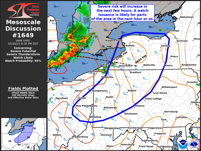
Mesoscale Discussion 1649
NWS Storm Prediction Center Norman OK
0845 AM CDT Tue Jul 16 2024

Areas affected...Extreme northeast KS into parts of MO and southwest
IL

Concerning...Severe Thunderstorm Watch 545...

Valid 161345Z - 161515Z

The severe weather threat for Severe Thunderstorm Watch 545
continues.

SUMMARY...Some threat for damaging/severe gusts may continue through
the morning. Additional watch issuance is possible.

DISCUSSION...One thunderstorm cluster with a history of producing
severe gusts is currently near Kansas City, with another potentially
severe storm cluster over north-central MO. Other less-organized
convection is ongoing from southeast MO into southwest IL. Evolution
of the ongoing convection through the morning remains uncertain,
with a pocket of diurnal heating potential in advance of the
north-central MO cluster, and some heating/destabilization also
expected south of the storms across southeast MO/southwest IL.

MUCAPE in excess of 1500 J/kg and marginally supportive deep-layer
shear could continue to support some organized severe-wind potential
through the morning, especially in advance of the north-central MO
cluster. Downstream watch issuance into parts of eastern MO is
possible, depending on short-term convective trends. Some severe
threat could also eventually evolve out of the southeast
MO/southwest IL convection.

..Dean/Hart.. 07/16/2024

...Please see www.spc.noaa.gov for graphic product...

ATTN...WFO...PAH...ILX...LSX...SGF...EAX...

LAT...LON   39729035 38748947 37948894 37168931 37249018 37779225
            38269348 38779467 38949478 39329508 39629480 39789342
            39729035
https://www.spc.noaa.gov/products/md/md1649.html
date: 2024-07-16, from: NOAA tornado/severe thunderstorm watches, mesoscale discussions, convective outlooks, fire weather outlooks

URGENT - IMMEDIATE BROADCAST REQUESTED
Severe Thunderstorm Watch Number 546
NWS Storm Prediction Center Norman OK
1105 AM EDT Tue Jul 16 2024

The NWS Storm Prediction Center has issued a

* Severe Thunderstorm Watch for portions of
  Western and Central New York
  Northern Pennsylvania
  Lake Erie
  Lake Ontario

* Effective this Tuesday morning and evening from 1105 AM until
  600 PM EDT.

* Primary threats include...
  Scattered damaging winds likely with isolated significant gusts
    to 75 mph possible
  Isolated very large hail events to 2 inches in diameter possible
  A tornado or two possible

SUMMARY...Thunderstorms are expected to intensify rapidly across
western New York and track across the watch area.  Favorably strong
winds aloft and warm/moist conditions will favor a risk of damaging
wind gusts and hail in the stronger cells.

The severe thunderstorm watch area is approximately along and 65
statute miles north and south of a line from 30 miles south
southwest of Buffalo NY to 20 miles east southeast of Utica NY. For
a complete depiction of the watch see the associated watch outline
update (WOUS64 KWNS WOU6).

PRECAUTIONARY/PREPAREDNESS ACTIONS...

REMEMBER...A Severe Thunderstorm Watch means conditions are
favorable for severe thunderstorms in and close to the watch area.
Persons in these areas should be on the lookout for threatening
weather conditions and listen for later statements and possible
warnings. Severe thunderstorms can and occasionally do produce
tornadoes.

&&

OTHER WATCH INFORMATION...CONTINUE...WW 545...

AVIATION...A few severe thunderstorms with hail surface and aloft to
2 inches. Extreme turbulence and surface wind gusts to 65 knots. A
few cumulonimbi with maximum tops to 500. Mean storm motion vector
27030.

...Hart
https://www.spc.noaa.gov/products/watch/ww0546.html
date: 2024-07-16, from: NOAA tornado/severe thunderstorm watches, mesoscale discussions, convective outlooks, fire weather outlooks
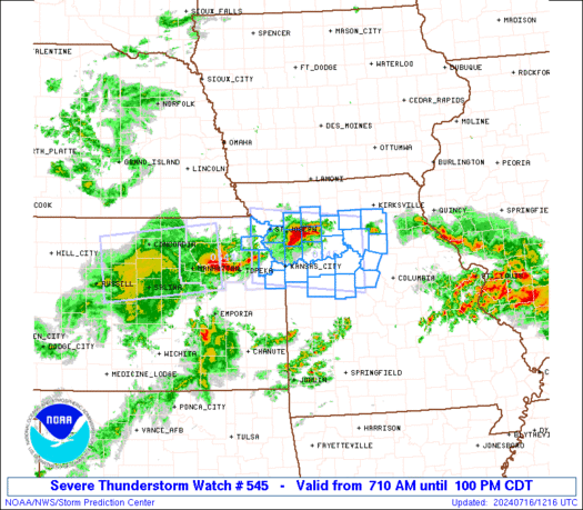
URGENT - IMMEDIATE BROADCAST REQUESTED
Severe Thunderstorm Watch Number 545
NWS Storm Prediction Center Norman OK
710 AM CDT Tue Jul 16 2024

The NWS Storm Prediction Center has issued a

* Severe Thunderstorm Watch for portions of
  Extreme northeastern Kansas
  Northwestern and north-central Missouri

* Effective this Tuesday morning and afternoon from 710 AM until
  100 PM CDT.

* Primary threats include...
  Scattered damaging winds and isolated significant gusts to 75
    mph possible
  Isolated very large hail events to 2 inches in diameter possible

SUMMARY...Clusters of strong-severe thunderstorms are expected to
move across the watch area through the remainder of the morning and
into midday, with severe gusts and isolated large hail as the
threats.

The severe thunderstorm watch area is approximately along and 45
statute miles north and south of a line from 25 miles west northwest
of Leavenworth KS to 55 miles southeast of Chillicothe MO. For a
complete depiction of the watch see the associated watch outline
update (WOUS64 KWNS WOU5).

PRECAUTIONARY/PREPAREDNESS ACTIONS...

REMEMBER...A Severe Thunderstorm Watch means conditions are
favorable for severe thunderstorms in and close to the watch area.
Persons in these areas should be on the lookout for threatening
weather conditions and listen for later statements and possible
warnings. Severe thunderstorms can and occasionally do produce
tornadoes.

&&

OTHER WATCH INFORMATION...CONTINUE...WW 544...

AVIATION...A few severe thunderstorms with hail surface and aloft to
2 inches. Extreme turbulence and surface wind gusts to 65 knots. A
few cumulonimbi with maximum tops to 550. Mean storm motion vector
27035.

...Edwards
https://www.spc.noaa.gov/products/watch/ww0545.html
date: 2024-07-16, from: NOAA tornado/severe thunderstorm watches, mesoscale discussions, convective outlooks, fire weather outlooks

STATUS REPORT ON WW 545

SEVERE WEATHER THREAT CONTINUES RIGHT OF A LINE FROM 30 WSW SZL
TO 35 SW LWD.

..HALBERT..07/16/24

ATTN...WFO...EAX...


STATUS REPORT FOR WS 545

SEVERE WEATHER THREAT CONTINUES FOR THE FOLLOWING AREAS

MOC025-033-041-053-061-089-101-107-115-117-121-159-175-177-195-
161540-

MO
.    MISSOURI COUNTIES INCLUDED ARE

CALDWELL             CARROLL             CHARITON
COOPER               DAVIESS             HOWARD
JOHNSON              LAFAYETTE           LINN
LIVINGSTON           MACON               PETTIS
RANDOLPH             RAY                 SALINE


THE WATCH STATUS MESSAGE IS FOR GUIDANCE PURPOSES ONLY.  PLEASE
REFER TO WATCH COUNTY NOTIFICATION STATEMENTS FOR OFFICIAL
INFORMATION ON COUNTIES...INDEPENDENT CITIES AND MARINE ZONES
CLEARED FROM SEVERE THUNDERSTORM AND TORNADO WATCHES.
https://www.spc.noaa.gov/products/watch/ws0545.html
date: 2024-07-16, from: NOAA tornado/severe thunderstorm watches, mesoscale discussions, convective outlooks, fire weather outlooks

161400-

STATUS REPORT ON WW 544

SEVERE WEATHER THREAT CONTINUES RIGHT OF A LINE FROM 20 WNW EMP
TO 15 WSW TOP.

WW 544 WILL BE ALLOWED TO EXPIRE AT 161400Z.

..HALBERT..07/16/24

ATTN...WFO...


STATUS REPORT FOR WS 544

SEVERE WEATHER THREAT CONTINUES FOR THE FOLLOWING AREAS

KSC045-087-177-161400-

KS
.    KANSAS COUNTIES INCLUDED ARE

DOUGLAS              JEFFERSON           SHAWNEE


THE WATCH STATUS MESSAGE IS FOR GUIDANCE PURPOSES ONLY.  PLEASE
REFER TO WATCH COUNTY NOTIFICATION STATEMENTS FOR OFFICIAL
INFORMATION ON COUNTIES...INDEPENDENT CITIES AND MARINE ZONES
CLEARED FROM SEVERE THUNDERSTORM AND TORNADO WATCHES.
https://www.spc.noaa.gov/products/watch/ws0544.html
date: 2024-07-14, from: NOAA tornado/severe thunderstorm watches, mesoscale discussions, convective outlooks, fire weather outlooks

Mesoscale Discussion 1615
NWS Storm Prediction Center Norman OK
0315 PM CDT Sun Jul 14 2024

Areas affected...Parts of IA...northern IL...southern WI

Concerning...Severe potential...Watch likely

Valid 142015Z - 142145Z

Probability of Watch Issuance...80 percent

SUMMARY...Strong to severe storm development is expected later this
afternoon into the evening. Eventual watch issuance is likely.

DISCUSSION...Rather strong heating/destabilization is underway
across much of IA this afternoon, while recovery in the wake of
morning convection/outflow is ongoing across northern IL. Meanwhile,
the remnant MCV from last night's severe MCS over the Dakotas is
currently moving across northern IA. As MLCINH continues to erode
across northern/eastern IA and MLCAPE increases above 3000 J/kg, the
MCV may aid in scattered thunderstorm development later this
afternoon. Midlevel flow is not particularly strong across the
region, but sufficient to support effective shear of 25-35 kt and
potential for some storm organization.

Initial discrete development could evolve into a supercell or two,
with a threat of hail, locally damaging wind, and possibly a
tornado. In conjunction with the MCV, a persistent 20-30 kt
southwesterly low-level jet could encourage relatively quick
clustering and upscale growth, with some potential for an MCS to
develop and move eastward across northern IL and southern WI this
evening, with a continued severe-wind threat.

Farther northwest, in the wake of the MCV, cumulus is deepening
along a weak surface boundary across northwest IA. While this area
is in the immediate wake of the MCV, strong buoyancy and sufficient
deep-layer shear would support severe-thunderstorm potential in this
area as well, if storms can mature.

While favored timing and area remain somewhat uncertain, watch
issuance will become increasingly likely if storm initiation appears
imminent across the region.

..Dean/Hart.. 07/14/2024

...Please see www.spc.noaa.gov for graphic product...

ATTN...WFO...LOT...ILX...MKX...DVN...ARX...DMX...FSD...

LAT...LON   41389383 41709465 42059481 42449490 42889500 43119456
            43259293 43209113 43169047 43068900 42938781 41838741
            41238742 40888855 40838996 40879116 40969178 41019259
            41389383
https://www.spc.noaa.gov/products/md/md1615.html
date: 2024-07-14, from: NOAA tornado/severe thunderstorm watches, mesoscale discussions, convective outlooks, fire weather outlooks

Mesoscale Discussion 1614
NWS Storm Prediction Center Norman OK
0206 PM CDT Sun Jul 14 2024

Areas affected...Southern IN into western OH

Concerning...Severe Thunderstorm Watch 532...

Valid 141906Z - 142030Z

The severe weather threat for Severe Thunderstorm Watch 532
continues.

SUMMARY...A threat for at least isolated damaging wind is expected
to continue through late afternoon.

DISCUSSION...A loosely organized MCS continues to move
east-southeastward across parts of southern IN into western OH this
afternoon. Recent measured gusts have generally been in the 30-45 kt
range, though some wind damage was reported earlier across northern
IN. Generally weak low/midlevel flow may continue to limit
organization potential through the afternoon. However, the
downstream thermodynamic environment remains favorable for
damaging-wind potential, with MLCAPE in excess of 1500 J/kg and
steepening low-level lapse rates, and some threat for at least
isolated damaging wind is expected to continue through late
afternoon.

..Dean.. 07/14/2024

...Please see www.spc.noaa.gov for graphic product...

ATTN...WFO...CLE...ILN...IWX...IND...

LAT...LON   39548660 39838515 40368389 40818402 41058404 41148380
            41118336 40938290 40638271 40258265 39728271 39488285
            39258323 39248480 39228608 39548660
https://www.spc.noaa.gov/products/md/md1614.html
date: 2024-07-14, from: NOAA tornado/severe thunderstorm watches, mesoscale discussions, convective outlooks, fire weather outlooks

STATUS REPORT ON WW 532

SEVERE WEATHER THREAT CONTINUES RIGHT OF A LINE FROM 40 SE IND TO
25 N LUK TO 25 ESE DAY TO 30 WNW MFD.

..LYONS..07/14/24

ATTN...WFO...IWX...IND...ILN...CLE...


STATUS REPORT FOR WS 532

SEVERE WEATHER THREAT CONTINUES FOR THE FOLLOWING AREAS

OHC027-033-041-045-047-049-057-073-083-089-097-101-117-129-141-
159-165-142140-

OH
.    OHIO COUNTIES INCLUDED ARE

CLINTON              CRAWFORD            DELAWARE
FAIRFIELD            FAYETTE             FRANKLIN
GREENE               HOCKING             KNOX
LICKING              MADISON             MARION
MORROW               PICKAWAY            ROSS
UNION                WARREN


THE WATCH STATUS MESSAGE IS FOR GUIDANCE PURPOSES ONLY.  PLEASE
REFER TO WATCH COUNTY NOTIFICATION STATEMENTS FOR OFFICIAL
INFORMATION ON COUNTIES...INDEPENDENT CITIES AND MARINE ZONES
CLEARED FROM SEVERE THUNDERSTORM AND TORNADO WATCHES.
https://www.spc.noaa.gov/products/watch/ws0532.html
date: 2024-07-14, from: NOAA tornado/severe thunderstorm watches, mesoscale discussions, convective outlooks, fire weather outlooks

URGENT - IMMEDIATE BROADCAST REQUESTED
Severe Thunderstorm Watch Number 532
NWS Storm Prediction Center Norman OK
1250 PM EDT Sun Jul 14 2024

The NWS Storm Prediction Center has issued a

* Severe Thunderstorm Watch for portions of
  Central Indiana
  Central Ohio

* Effective this Sunday afternoon and evening from 1250 PM until
  700 PM EDT.

* Primary threats include...
  Scattered damaging wind gusts to 70 mph likely
  Isolated large hail events to 1.5 inches in diameter possible

SUMMARY...A line of thunderstorms over northern Indiana will track
southeastward across the watch area through the afternoon, posing a
risk of locally damaging wind gusts and hail.

The severe thunderstorm watch area is approximately along and 55
statute miles north and south of a line from 45 miles north
northwest of Indianapolis IN to 30 miles east northeast of Columbus
OH. For a complete depiction of the watch see the associated watch
outline update (WOUS64 KWNS WOU2).

PRECAUTIONARY/PREPAREDNESS ACTIONS...

REMEMBER...A Severe Thunderstorm Watch means conditions are
favorable for severe thunderstorms in and close to the watch area.
Persons in these areas should be on the lookout for threatening
weather conditions and listen for later statements and possible
warnings. Severe thunderstorms can and occasionally do produce
tornadoes.

&&

AVIATION...A few severe thunderstorms with hail surface and aloft to
1.5 inches. Extreme turbulence and surface wind gusts to 60 knots. A
few cumulonimbi with maximum tops to 500. Mean storm motion vector
29030.

...Hart