(date: 2024-11-02 18:00:59)
date: 2024-11-01, from: NOAA tornado/severe thunderstorm watches, mesoscale discussions, convective outlooks, fire weather outlooks

Day 1 Fire Weather Outlook
NWS Storm Prediction Center Norman OK
1126 AM CDT Fri Nov 01 2024

Valid 011700Z - 021200Z

The primary changes made to the Day 1 Fire Weather Outlook Update
was to expand Elevated highlights into southern Pennsylvania, and
northeast to portions of coastal New England. In these areas ahead
of the cold front, clearing skies are leading to rapid
boundary-layer mixing and lowering of RH. Sustained surface winds
are already reaching 20 mph in spots, with higher gusts, and
short-range guidance consensus suggests that RH should drop to 30-35
percent RH by mid-afternoon. As such, Elevated fire weather
conditions remain likely given the presence of dry fuels.

..Squitieri.. 11/01/2024

.PREV DISCUSSION... /ISSUED 0158 AM CDT Fri Nov 01 2024/

...Synopsis...
On the backside of a midlevel trough tracking east-northeastward
across the Northeast, deep tropospheric drying will occur across
portions of the Mid-Atlantic behind a related cold front. A tight
pressure gradient and enhanced low-level flow will yield 15 mph
sustained westerly surface winds (with gusts upwards of 25-30 mph).
These winds will overlap 25-35 percent RH behind the front during
the afternoon, and given very dry fuels across the region (90th
percentile ERCs), a few hours of elevated fire-weather conditions
are expected. While there will be some potential for isolated
early-day showers along the front, this activity should be too light
and/or isolated to have an appreciable impact on the receptive
fuels.

...Please see www.spc.noaa.gov/fire for graphic product...
https://www.spc.noaa.gov/products/fire_wx/fwdy1.html
date: 2024-11-01, from: NOAA tornado/severe thunderstorm watches, mesoscale discussions, convective outlooks, fire weather outlooks

Day 1 Convective Outlook
NWS Storm Prediction Center Norman OK
1117 AM CDT Fri Nov 01 2024

Valid 011630Z - 021200Z

...THERE IS A MARGINAL RISK OF SEVERE THUNDERSTORMS ACROSS PARTS OF
THE SOUTHERN HIGH PLAINS...

...SUMMARY...
Isolated severe hail and/or gusts are possible across parts of the
southern High Plains, from this evening into the overnight.

...Southern High Plains...
Visible-satellite imagery late this morning shows patches of
stratocumulus over the Pecos River Valley.  This low-level moisture
coincides with the northwesterly fringe of richer moisture located
over the Hill Country and Deep South TX.  The timelapse of
water-vapor imagery shows the onset of an amplifying large-scale
trough over the West.  A lead lower-latitude disturbance over
northern Baja and Sonora will shift eastward along the Mexican
border during the period and aid in the development of a lee trough
over the southern High Plains beneath moderately strong
southwesterly mid-level flow.

A gradual intensification of low-level warm-air advection downstream
of the upper trough will occur through tonight across the southern
High Plains.  Model guidance continues to indicate widely
spaced/isolated thunderstorms will develop late this afternoon and
into the evening across Far West TX into southeastern NM as 500-1000
J/kg MLCAPE develops coincident with the increase in low-level
moisture.  Thunderstorm coverage should increase from late this
evening through the overnight hours, and begin training within a
southwest/northeast-oriented plume from far west TX to southern KS.
This convective growth will be related to strengthening low-level
theta-e and moisture, WAA-related large-scale ascent, and weakening
MUCINH.  The most intense cells embedded in this regime may produce
severe hail or gusts, but the overall areal severe threat still
appears to be on the  marginal side, due to lack of greater
instability/buoyancy.

..Smith/Moore.. 11/01/2024
https://www.spc.noaa.gov/products/outlook/day1otlk_1630.html
date: 2024-11-01, from: Eastern Pacific Basin GIS Data
No tropical cyclones as of Fri, 01 Nov 2024 16:02:05 GMT
date: 2024-10-31, from: NOAA tornado/severe thunderstorm watches, mesoscale discussions, convective outlooks, fire weather outlooks
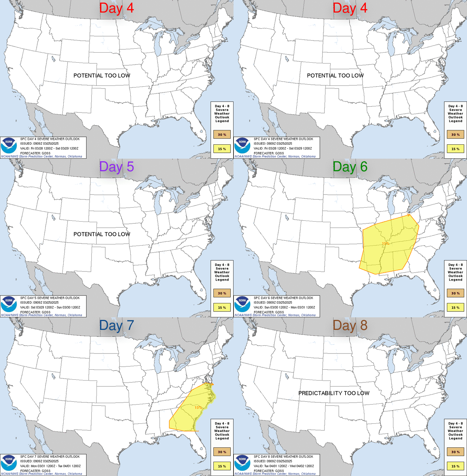
Day 4-8 Convective Outlook
NWS Storm Prediction Center Norman OK
0354 AM CDT Thu Oct 31 2024

Valid 031200Z - 081200Z

...DISCUSSION...
...Sunday/Day 4 and Monday/Day 5...
An upper-level trough is forecast to move across the Desert
Southwest on Sunday, as the exit region of a broad mid-level jet
overspreads the southern and central Plains. Ahead of the system, a
moist airmass will likely be in place. Scattered thunderstorms are
expected to develop within this moist airmass Sunday afternoon as
instability increases during the day. Surface dewpoints in the 60s
F, low-end moderate instability and moderate to strong deep-layer
shear should support severe thunderstorm development Sunday
afternoon and evening. The greatest severe potential is expected
from north Texas northward into south-central Nebraska, where large
hail, severe wind gusts and an isolated tornado threat will be
possible.

On Monday, the trough is forecast to move into the southern High
Plains, as a 80 to 90 knot mid-level jet translates through the
eastern part of the system. Ahead of the trough, pockets of moderate
instability are forecast to develop across a moist airmass during
the day. Thunderstorms that form in the afternoon across the western
part of the moist sector are expected to have potential for large
hail and wind damage.

...Tuesday/Day 6 to Thursday/Day 8...
From Tuesday to Thursday, an upper-level trough is forecast to move
quickly eastward across the northern U.S., as a cold front advances
southeastward across the eastern third of the U.S. Warming surface
temperatures ahead of the front should result in scattered
thunderstorm development each afternoon and evening. The greatest
severe threat could be on Tuesday in the lower to mid Mississippi
Valley near the entrance region of the mid-level jet. The severe
threat could re-develop ahead of the front on Wednesday and
Thursday. However, instability is forecast to be weak suggesting
that any severe threat should be marginal.
https://www.spc.noaa.gov/products/exper/day4-8/
date: 2024-10-31, from: NOAA Weather Forecasts
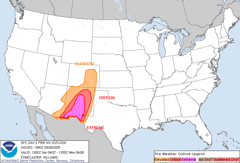
Day 2 Fire Weather Outlook
NWS Storm Prediction Center Norman OK
0157 AM CDT Thu Oct 31 2024

Valid 011200Z - 021200Z

...NO CRITICAL AREAS...

...Synopsis...
Quasi-zonal mid-level flow will persist over the US Friday as an
upper trough moves offshore. A cold front will follow, with high
pressure building over the central US. Behind the front, dry
offshore flow is likely over parts of the Northeast and Mid Atlantic
Coast. Downslope winds are also possible over parts of the central
Rockies and High Plains. While localized gusty winds are possible,
the lack of stronger synoptic winds suggests fire-weather concerns
are low.

...Northeast...
In the wake of the aforementioned cold front, a couple hours of dry
and breezy conditions are possible across the Mid Atlantic Coast.
Breezy 10-15 mph winds are possible through midday with adiabatic
drying supporting somewhat lower RH within very dry fuels. However,
offshore pressure gradients should gradually weaken through the
afternoon, with the strongest winds quickly abating. While fuels are
very dry, the overlap with gusty winds and low humidity will be
brief and localized.

..Lyons.. 10/31/2024

...Please see www.spc.noaa.gov/fire for graphic product...
https://www.spc.noaa.gov/products/fire_wx/fwdy2.html
date: 2024-10-30, from: NOAA tornado/severe thunderstorm watches, mesoscale discussions, convective outlooks, fire weather outlooks
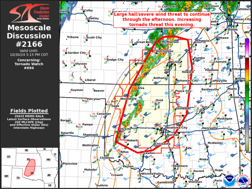
Mesoscale Discussion 2166
NWS Storm Prediction Center Norman OK
0345 PM CDT Wed Oct 30 2024

Areas affected...southern Kansas and northwest/central/northern
Oklahoma.

Concerning...Tornado Watch 694...

Valid 302045Z - 302215Z

The severe weather threat for Tornado Watch 694 continues.

SUMMARY...The large hail/severe wind threat is expected to continue
through the afternoon as supercells move across northwest Oklahoma
and into southern Kansas. The tornado threat is expected to increase
this evening.

DISCUSSION...Supercells have developed along the dryline in western
Oklahoma. Thus far, one measured wind gust of 70 mph has been
observed with MRMS MESH suggesting around 1 to 1.25 inch hail. As
these supercells mature, expect the threat for large hail and severe
wind gusts to continue. Low-level shear is quite weak this afternoon
(60-70 m2/s2 0-500 SRH per VNX VWP), but is forecast to increase
substantially after 22-23Z as the low-level jet strengthens. During
this time is when the greatest tornado threat is anticipated.
Eventually, expect storms to congeal into a squall line with severe
wind and a few embedded QLCS tornadoes as the primary threat.

..Bentley/Gleason.. 10/30/2024

...Please see www.spc.noaa.gov for graphic product...

ATTN...WFO...TSA...TOP...ICT...OUN...DDC...

LAT...LON   35059955 36819900 37909829 38429790 38619757 38649711
            38519651 37559635 35999661 35249716 34789802 34689863
            35059955
https://www.spc.noaa.gov/products/md/md2166.html
date: 2024-10-30, from: NOAA tornado/severe thunderstorm watches, mesoscale discussions, convective outlooks, fire weather outlooks

Mesoscale Discussion 2165
NWS Storm Prediction Center Norman OK
0305 PM CDT Wed Oct 30 2024

Areas affected...Southern Iowa and far northern Missouri

Concerning...Severe Thunderstorm Watch 693...

Valid 302005Z - 302200Z

The severe weather threat for Severe Thunderstorm Watch 693
continues.

SUMMARY...A line of storms will continue to pose a risk of damaging
winds across southern Iowa and far northern Missouri over the next
few hours. However, downstream watch issuance is not currently
anticipated given recent convective trends.

DISCUSSION...An organized bowing segment with a history of producing
severe winds continues to migrate across south-central IA. However,
a decrease in vertically integrated ice, VIL, and echo top height
has been noted over the past 30 minutes, suggesting that the severe
wind threat may be decreasing in spatial extent and/or intensity to
some degree. This is likely attributable to the QLCS meandering into
a slightly more stable air mass where daytime heating has been muted
due to preceding clouds and light rain. Despite these trends,
gradual destabilization continues immediately downstream of the line
and ahead of the cold front due to strong low-level warm/moist
advection with MLCAPE estimates up to 500 J/kg per mesoanalysis and
RAP forecast soundings. The combination of modest
destabilization/ascent and favorable deep-layer, line-orthogonal
wind shear may maintain the severe wind threat downstream through
the remainder of WW 693. Additional watch issuance into
southeast/eastern IA remains uncertain and will be conditional on
convective trends over the next 1-2 hours.

..Moore.. 10/30/2024

...Please see www.spc.noaa.gov for graphic product...

ATTN...WFO...DVN...DMX...EAX...

LAT...LON   41459431 42289321 42459298 42499275 42479252 42399239
            42279228 41519209 40899209 40549230 40359263 40289311
            40459436 40639442 41049442 41459431
https://www.spc.noaa.gov/products/md/md2165.html
date: 2024-10-30, from: NOAA tornado/severe thunderstorm watches, mesoscale discussions, convective outlooks, fire weather outlooks
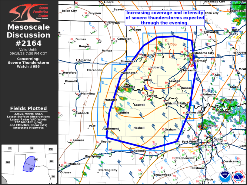
Mesoscale Discussion 2164
NWS Storm Prediction Center Norman OK
0303 PM CDT Wed Oct 30 2024

Areas affected...northeast Kansas into southeast Nebraska and far
northwest Missouri

Concerning...Severe potential...Watch likely

Valid 302003Z - 302200Z

Probability of Watch Issuance...80 percent

SUMMARY...Airmass recovery should result in some severe storms this
afternoon and evening.

DISCUSSION...Widespread showers and thunderstorms across northeast
Kansas has stunted destabilization thus far. However, some clearing
and low-level moisture advection in the wake of the morning activity
has started to destabilize parts of northeast Kansas. A line of
storms is starting to organize across central Kansas which is
expected to continue to grow upscale as it moves northeast. Expect
sufficient destabilization ahead of this line of storms for some
threat for severe wind gusts, large hail, and potentially a few
tornadoes (along and south of the front). A tornado watch will
likely need to be issued within the next hour or two across
northeast Kansas, to fill the gap between watch 693 and 694.

..Bentley/Gleason.. 10/30/2024

...Please see www.spc.noaa.gov for graphic product...

ATTN...WFO...EAX...OAX...TOP...ICT...

LAT...LON   38709796 39259727 39969597 40299515 40279402 40039335
            39259334 38549390 38279506 38109600 38219708 38479809
            38709796
https://www.spc.noaa.gov/products/md/md2164.html
date: 2024-10-30, from: NOAA tornado/severe thunderstorm watches, mesoscale discussions, convective outlooks, fire weather outlooks

STATUS REPORT ON WW 693

SEVERE WEATHER THREAT CONTINUES RIGHT OF A LINE FROM 25 WNW FLV
TO 35 SW LWD TO 25 SSW DSM TO 35 SSE FOD.

FOR ADDITIONAL INFORMATION SEE MESOSCALE DISCUSSION 2165

..MOORE..10/30/24

ATTN...WFO...DMX...OAX...EAX...


STATUS REPORT FOR WS 693

SEVERE WEATHER THREAT CONTINUES FOR THE FOLLOWING AREAS

IAC007-039-051-053-099-117-123-125-127-135-153-157-171-179-181-
185-302140-

IA
.    IOWA COUNTIES INCLUDED ARE

APPANOOSE            CLARKE              DAVIS
DECATUR              JASPER              LUCAS
MAHASKA              MARION              MARSHALL
MONROE               POLK                POWESHIEK
TAMA                 WAPELLO             WARREN
WAYNE


MOC001-021-061-063-079-081-129-171-197-211-302140-

MO
.    MISSOURI COUNTIES INCLUDED ARE

ADAIR                BUCHANAN            DAVIESS
DEKALB               GRUNDY              HARRISON
MERCER               PUTNAM              SCHUYLER
SULLIVAN
https://www.spc.noaa.gov/products/watch/ws0693.html
date: 2024-10-30, from: NOAA tornado/severe thunderstorm watches, mesoscale discussions, convective outlooks, fire weather outlooks

URGENT - IMMEDIATE BROADCAST REQUESTED
Severe Thunderstorm Watch Number 693
NWS Storm Prediction Center Norman OK
130 PM CDT Wed Oct 30 2024

The NWS Storm Prediction Center has issued a

* Severe Thunderstorm Watch for portions of
  Southern/Central Iowa
  Extreme Northeast Kansas
  Northern Missouri

* Effective this Wednesday afternoon and evening from 130 PM
  until 700 PM CDT.

* Primary threats include...
  Scattered damaging winds likely with isolated significant gusts
    to 80 mph possible
  Isolated large hail events to 1.5 inches in diameter possible
  A tornado or two possible

SUMMARY...A bowing thunderstorm cluster will likely continue to pose
a threat for scattered severe/damaging winds potentially up to 70-80
mph as it continues east-northeastward across northern Missouri and
southern/central Iowa this afternoon and early evening. Isolated
hail and perhaps a tornado may also occur.

The severe thunderstorm watch area is approximately along and 60
statute miles north and south of a line from 50 miles north
northwest of Saint Joseph MO to 5 miles northeast of Ottumwa IA. For
a complete depiction of the watch see the associated watch outline
update (WOUS64 KWNS WOU3).

PRECAUTIONARY/PREPAREDNESS ACTIONS...

REMEMBER...A Severe Thunderstorm Watch means conditions are
favorable for severe thunderstorms in and close to the watch area.
Persons in these areas should be on the lookout for threatening
weather conditions and listen for later statements and possible
warnings. Severe thunderstorms can and occasionally do produce
tornadoes.

&&

AVIATION...A few severe thunderstorms with hail surface and aloft to
1.5 inches. Extreme turbulence and surface wind gusts to 70 knots. A
few cumulonimbi with maximum tops to 500. Mean storm motion vector
22040.

...Gleason
https://www.spc.noaa.gov/products/watch/ww0693.html
date: 2024-10-30, from: NOAA tornado/severe thunderstorm watches, mesoscale discussions, convective outlooks, fire weather outlooks

URGENT - IMMEDIATE BROADCAST REQUESTED
Tornado Watch Number 694
NWS Storm Prediction Center Norman OK
205 PM CDT Wed Oct 30 2024

The NWS Storm Prediction Center has issued a

* Tornado Watch for portions of
  South-Central Kansas
  Western into Central/North-Central Oklahoma

* Effective this Wednesday afternoon and evening from 205 PM
  until 900 PM CDT.

* Primary threats include...
  A few tornadoes likely with a couple intense tornadoes possible
  Scattered damaging winds likely with isolated significant gusts
    to 75 mph possible
  Scattered large hail and isolated very large hail events to 2.5
    inches in diameter possible

SUMMARY...Developing supercells will pose a threat for large to very
large hail initially (up to 1.5-2.5 inches in diameter). Later this
afternoon into the evening, the threat for a few tornadoes will
increase. A strong tornado or two appears possible, especially early
this evening. Scattered severe/damaging winds will also become a
concern later this evening as thunderstorms eventually form into a
line.

The tornado watch area is approximately along and 55 statute miles
east and west of a line from 35 miles northeast of Hutchinson KS to
35 miles east of Clinton OK. For a complete depiction of the watch
see the associated watch outline update (WOUS64 KWNS WOU4).

PRECAUTIONARY/PREPAREDNESS ACTIONS...

REMEMBER...A Tornado Watch means conditions are favorable for
tornadoes and severe thunderstorms in and close to the watch
area. Persons in these areas should be on the lookout for
threatening weather conditions and listen for later statements
and possible warnings.

&&

OTHER WATCH INFORMATION...CONTINUE...WW 693...

AVIATION...Tornadoes and a few severe thunderstorms with hail
surface and aloft to 2.5 inches. Extreme turbulence and surface wind
gusts to 65 knots. A few cumulonimbi with maximum tops to 500. Mean
storm motion vector 24035.

...Gleason
https://www.spc.noaa.gov/products/watch/ww0694.html
date: 2024-10-30, from: NOAA tornado/severe thunderstorm watches, mesoscale discussions, convective outlooks, fire weather outlooks

STATUS REPORT ON WW 694

SEVERE WEATHER THREAT CONTINUES RIGHT OF A LINE FROM 35 NW P28 TO
25 WNW HUT TO 10 S SLN.

..BENTLEY..10/30/24

ATTN...WFO...DDC...ICT...OUN...


STATUS REPORT FOR WT 694

SEVERE WEATHER THREAT CONTINUES FOR THE FOLLOWING AREAS

KSC007-015-017-035-077-079-095-115-151-155-173-191-302140-

KS
.    KANSAS COUNTIES INCLUDED ARE

BARBER               BUTLER              CHASE
COWLEY               HARPER              HARVEY
KINGMAN              MARION              PRATT
RENO                 SEDGWICK            SUMNER


OKC003-011-015-017-027-039-043-047-051-053-071-073-083-087-093-
103-109-119-149-151-153-302140-

OK
.    OKLAHOMA COUNTIES INCLUDED ARE

ALFALFA              BLAINE              CADDO
CANADIAN             CLEVELAND           CUSTER
DEWEY                GARFIELD            GRADY
GRANT                KAY                 KINGFISHER
LOGAN                MCCLAIN             MAJOR
NOBLE                OKLAHOMA            PAYNE
WASHITA              WOODS               WOODWARD
https://www.spc.noaa.gov/products/watch/ws0694.html
date: 2024-10-30, from: NOAA tornado/severe thunderstorm watches, mesoscale discussions, convective outlooks, fire weather outlooks

Day 1 Convective Outlook
NWS Storm Prediction Center Norman OK
0254 PM CDT Wed Oct 30 2024

Valid 302000Z - 311200Z

...THERE IS AN ENHANCED RISK OF SEVERE THUNDERSTORMS
NORTHERN/CENTRAL OKLAHOMA INTO CENTRAL/EASTERN KANSAS AND WESTERN
MISSOURI...

...SUMMARY...
Severe thunderstorms capable of producing scattered large hail,
numerous damaging wind gusts, and a few tornadoes are expected today
into tonight across the middle Missouri Valley and central/southern
Plains, including parts of eastern Kansas/Oklahoma into Missouri and
vicinity. A strong tornado or two is possible across
south-central/southeastern Kansas into central Oklahoma.

...20z Update...
The Enhanced Risk was expanded further southward through the
Oklahoma City metro with this update. The Slight Risk was also
expanded further west and southward. Recent trends in satellite and
radar have shown cell development further south and west along the
dryline than previously forecast. The environment across central
Oklahoma is favorable for maintenance of supercells, with daytime
heating yielding MLCAPE around 1500 J/kg and shear around 40 kts
progged to increase with the increasing low level jet this
afternoon/evening. Boundary parallel shear and overtaking of the
dryline by the cold front will lead to a transition to more linear
structure around sunset. However, deep layer shear profiles will
continue to support embedded supercell structures after dark with
the potential for tornadoes, some strong, to continue through the
evening. Large hail will also be a concern late afternoon/early
evening while discrete mode is maintained.

Tornado probabilities were adjusted across northeastern Kansas to
account for progression of the cold front and earlier convective
activity. See previous discussion for more information.

..Thornton/Gleason.. 10/30/2024

.PREV DISCUSSION... /ISSUED 1130 AM CDT Wed Oct 30 2024/

...Southern/Central Plains into the Mid Missouri Valley...
The lead portion of an upper trough centered over the Rockies and
Four Corners will eject northeastward over the central Plains today.
A related surface low will likewise develop northeastward along a
cold front from the southern High Plains to IA by this evening. A
dryline extending southward from this low will mix eastward across
western OK and west TX through late this afternoon before stalling.
Robust low-level warm/moist advection will continue today across the
southern/central Plains along and south/east of the cold front and
dryline. Generally elevated thunderstorms have developed this
morning across parts of central KS, as large-scale ascent preceding
the ejecting upper trough has begun to overspread the central
Plains. This activity should tend to remain just to the cool side of
the front through the early afternoon. But, this convection may pose
some threat for severe hail given sufficient MUCAPE with steepening
mid-level lapse rates in the presence of strong deep-layer shear.
There is also some chance it eventually becomes surface based later
this afternoon across northeast KS.

Otherwise, continued filtered daytime heating of the moistening warm
sector should support around 500-1500 J/kg of MLCAPE by late
afternoon from southern IA into eastern KS/western MO, and locally
stronger to around 2000 J/kg in north-central OK. Current
expectations are for surface-based thunderstorms to initiate by
20-22Z across central/eastern KS and north-central/northwest OK, in
close proximity to the surface low and front/dryline intersection.
Rather strong (50-80 kt) southwesterly mid-level flow will overlie
this region this afternoon/evening, along with enhanced
south-southwesterly flow in the 850-700 mb layer. Related deep-layer
shear around 45-60 kt will easily support supercells and associated
threat for scattered hail initially. Isolated very large hail may
occur from south-central KS into north-central OK with any sustained
supercell given the rather favorable overlap of moderate instability
with steepened mid-level lapse rates and strong deep-layer shear.

With time this evening, upscale growth into a QLCS with greater
threat for severe/damaging winds is anticipated. This
severe/damaging wind threat should continue tonight as the line
spreads eastward across IA/MO, before eventually becoming more
isolated/diminishing with eastward extent into the mid MS Valley.
The tornado potential should also increase late this afternoon and
evening, as a southerly low-level jet and related 0-1 km SRH
strengthens rapidly through 23-04Z. The potential for sustained
supercells in central/eastern KS and north-central OK remains
somewhat unclear, but any semi-discrete activity will pose a threat
for tornadoes, a couple of which could be strong given the favorable
low-level shear and hodograph curvature. Embedded mesovorticies
within the QLCS will also be possible. Based on latest guidance and
observational trends, severe probabilities have been expanded
westward some across KS/OK, especially in the vicinity of the
expected front/dryline intersection. The Enhanced Risk has also been
expanded slightly eastward in western MO to account for scattered to
numerous severe wind gusts with the QLCS this evening.

Convective initiation may be delayed until around 00Z or later
across central/eastern OK. But, potential for discrete supercells
may be a bit better across this region given the dryline as the
initiating boundary, and somewhat less large-scale ascent with
southward extent away from the cold front. Any convection that can
develop and be sustained will likely be supercellular for at least a
couple of hours this evening, before upscale growth eventually
occurs along the cold front. A threat for large hail and tornadoes
will exist with any supercell, before the damaging wind threat
increases as the convective mode becomes more linear.

...Southeast Texas...
There is some potential that a few stronger/potentially rotating
thunderstorms could materialize today across the region within a
very moist and confluent low-level flow regime. This would be as
low-level lapse rates diurnally steepen coincident with a moderate
degree of low-level hodograph length and curvature. Modest-strength
winds above 2km AGL should limit the sustainability and intensity
for any showers/thunderstorms that may exhibit rotating
characteristics, and the overall severe potential should tend to
remain limited.
https://www.spc.noaa.gov/products/outlook/day1otlk_2000.html
date: 2024-10-30, from: NOAA tornado/severe thunderstorm watches, mesoscale discussions, convective outlooks, fire weather outlooks

Day 3 Convective Outlook
NWS Storm Prediction Center Norman OK
0218 PM CDT Wed Oct 30 2024

Valid 011200Z - 021200Z

...THERE IS A MARGINAL RISK OF SEVERE THUNDERSTORMS OVER THE
SOUTHERN HIGH PLAINS...

...SUMMARY...
A few strong storms capable of producing marginal hail are expected
to develop Friday night over the southern High Plain region.

...Synopsis...
Amplification of the upper flow field across the western and central
U.S. is forecast, as mid-level short-wave energy on the western side
of a low near Vancouver Island digs south-southeastward across the
eastern Pacific toward California.  This will result in
amplification of cyclonic flow over the West and, in response,
increased ridging/anticyclonic flow over the central states.

At the surface, high pressure will prevail in the wake of a cold
front expected to move eastward across New England through the day,
while trailing west-to-east across the Carolinas and Gulf Coast
States, and into the southern Plains.

Meanwhile over the West, a cold front is forecast to advance across
the northwestern states and eventually into the Great Basin, in
response to the digging upper system.

...Southern High Plains...
Development of scattered/elevated storms is expected overnight
across the southern High Plains area, within a zone of low-level
warm advection near and north of the remnant surface baroclinic
zone.  Rather steep lapse rates aloft will contribute to ample CAPE,
while moderate southwesterly mid-level flow will allow sufficient
cloud-layer shear for a few stronger updrafts.  This suggests
potential for hail near or in excess of severe levels with these
potentially stronger storms.

..Goss.. 10/30/2024
https://www.spc.noaa.gov/products/outlook/day3otlk_1930.html
date: 2024-10-30, from: NOAA tornado/severe thunderstorm watches, mesoscale discussions, convective outlooks, fire weather outlooks

Day 2 Convective Outlook
NWS Storm Prediction Center Norman OK
1226 PM CDT Wed Oct 30 2024

Valid 311200Z - 011200Z

...THERE IS A MARGINAL RISK OF SEVERE THUNDERSTORMS FROM SOUTHERN
LOWER MICHIGAN SOUTHWESTWARD TO NORTHEASTERN TEXAS/NORTHERN
LOUISIANA...

...SUMMARY...
Locally strong storms -- a couple of which may produce marginally
severe gusts -- will be possible Thursday morning and afternoon,
from the Midwest to northeastern Texas/northern Louisiana.

...Synopsis...
A progressing short-wave trough initially forecast over the Middle
Missouri Valley area is expected to move quickly northeastward
toward/across the Great Lakes region through the first half of the
period, and then into Ontario/Quebec overnight.  At the surface, an
associated cold front will move eastward across the Great Lakes and
Ohio Valley areas, while moving more slowly southeastward across the
Lower Mississippi Valley and southern Plains.  By the end of the
period, the boundary should extend from the Northeast to the Texas
Coast.

...Southern Lower Michigan southwest to northeastern Texas/northern
Louisiana...
Showers and thunderstorms will be ongoing near and ahead of an
advancing cold front -- which is initially forecast to lie from the
southern Wisconsin vicinity southwestward to central Texas.  With
the associated upper system forecast to be ejecting quickly
northeastward into/across the Upper Great Lakes region, decreasing
ascent and weakening flow aloft is expected with time from roughly
the Ohio Valley southward.  Meanwhile, weak instability north of the
Ohio Valley will be an overall limiting factor, despite more
favorable kinematics.

Overall, it appears that Level 1/MRGL risk remains appropriate, to
cover the potential for a few stronger storms/line segments to
produce strong/gusty winds that may locally reach severe levels.
Risk should be greatest during the morning and afternoon hours,
after which decreasing convective intensity and attendant severe
potential is expected.

..Goss.. 10/30/2024
https://www.spc.noaa.gov/products/outlook/day2otlk_1730.html
date: 2024-10-30, from: NOAA tornado/severe thunderstorm watches, mesoscale discussions, convective outlooks, fire weather outlooks

Mesoscale Discussion 2161
NWS Storm Prediction Center Norman OK
0907 AM CDT Wed Oct 30 2024

Areas affected...central/northern Kansas into southeast Nebraska

Concerning...Severe potential...Watch unlikely

Valid 301407Z - 301530Z

Probability of Watch Issuance...20 percent

SUMMARY...Elevated storms capable of some large hail are possible
this morning from portions of central Kansas into southeast
Nebraska.

DISCUSSION...Lightning has increased across central Kansas as ascent
increases across the Plains within a moderately unstable
environment. The TOP 12Z RAOB indicated around 1300 J/kg MUCAPE and
continued low-level moisture advection and mid-level cooling should
increase instability as the morning progresses. Effective shear was
actually quite weak at 12Z with a 60 knot low-level jet near the
low-level jet and 60 knots at 7km with weaker flow between this
layer. However, as the mid-level jet streak approaches the region
and nocturnal influences of the low-level jet reduce, a more
favorable, gradually increasing wind profile with height is expected
to develop by late morning to early afternoon. As instability and
the wind profile improve, eventually expect some supercells to
develop along or slightly on the cool side of the cold front.
Isolated large hail will be the primary threat from this activity
later this morning and into the early afternoon. A watch likely will
not be needed in the short term.

..Bentley/Gleason.. 10/30/2024

...Please see www.spc.noaa.gov for graphic product...

ATTN...WFO...EAX...OAX...TOP...ICT...GID...DDC...

LAT...LON   37110000 37939979 39269915 39729849 40519649 40619585
            40539567 40359558 39959604 38889745 38299801 37699865
            37329913 37069966 37110000
https://www.spc.noaa.gov/products/md/md2161.html
date: 2024-10-26, from: Eastern Pacific Basin Tropical Cyclones
000
WTPZ42 KNHC 260837
TCDEP2

Hurricane Kristy Discussion Number  19
NWS National Hurricane Center Miami FL       EP122024
200 AM PDT Sat Oct 26 2024

Kristy continues to weaken this morning. While the hurricane is
still producing an area of fairly deep convection, this convection
is becoming stretched poleward as south-southwesterly vertical wind
shear steadily increases over the tropical cyclone. Subjective
Dvorak estimates are constrained from decreasing faster this
morning, but taking a blend of subjective and objective intensity
estimates yields an intensity of 85 kt for this advisory. The shear
diagnosed by SHIPS guidance and UW-CIMSS analysis is now up to 30
kt, and is forecast to increase above 40 kt in 24 h. In addition,
Kristy is now crossing the 26 C isotherm and heading for even cooler
ocean waters. This combination should continue to result in rapid
weakening, with the hurricane likely to vertically decouple later
today. The NHC intensity forecast continues to blend the previous
forecast with the latest consensus aids, showing Kristy weakening
below hurricane intensity by this evening. Remnant low status is
likely not far behind on Sunday as the cyclone ceases to produce
organized deep convection, as depicted by both global and
regional-hurricane models. The remnant low low should finally open
up into a trough on Monday.

The hurricane has maintained a northwestward motion this morning at
320/13 kt. While the prominent subtropical mid-level ridge over Baja
California steering Kristy should remain in place, the tropical
cyclone's vertically deep vortex will likely decouple over the next
24 h. This decoupling will result in the mid-level vortex leaving
behind Kristy's surface circulation, which should quickly slow down
and turn westward as it becomes primarily influenced by strong
low-level ridging to its north. The track guidance continues to be
in relative good agreement with the prior forecast track, and only
minor adjustments were made from the previous forecast.


FORECAST POSITIONS AND MAX WINDS

INIT  26/0900Z 18.7N 127.6W   85 KT 100 MPH
 12H  26/1800Z 20.0N 128.5W   65 KT  75 MPH
 24H  27/0600Z 21.8N 129.5W   45 KT  50 MPH
 36H  27/1800Z 22.6N 130.2W   30 KT  35 MPH...POST-TROP/REMNT LOW
 48H  28/0600Z 22.4N 131.4W   25 KT  30 MPH...POST-TROP/REMNT LOW
 60H  28/1800Z...DISSIPATED

$$
Forecaster Papin
https://www.nhc.noaa.gov/text/refresh/MIATCDEP2+shtml/260837.shtml
date: 2024-10-26, from: Eastern Pacific Basin GIS Data
KMZ last updated Sat, 26 Oct 2024 08:36:13 GMT
https://www.nhc.noaa.gov/storm_graphics/api/EP122024_019adv_TRACK.kmz
date: 2024-10-26, from: Eastern Pacific Basin GIS Data
Track, Points, and Wind Swath. Shapefile last updated Sat, 26 Oct 2024 08:35:44 GMT
https://www.nhc.noaa.gov/gis/best_track/ep122024_best_track.zip
date: 2024-10-26, from: Eastern Pacific Basin GIS Data
KMZ last updated Sat, 26 Oct 2024 08:35:44 GMT
https://www.nhc.noaa.gov/gis/best_track/ep122024_best_track.kmz
date: 2024-10-26, from: Eastern Pacific Basin GIS Data
Initial and Forecast Surface Winds. Shapefile last updated Sat, 26 Oct 2024 08:35:44 GMT
https://www.nhc.noaa.gov/gis/forecast/archive/ep122024_fcst_019.zip
date: 2024-10-26, from: Eastern Pacific Basin GIS Data
KMZ last updated Sat, 26 Oct 2024 08:35:35 GMT
https://www.nhc.noaa.gov/storm_graphics/api/EP122024_019adv_CONE.kmz
date: 2024-10-26, from: Eastern Pacific Basin GIS Data
Forecast Track, Cone of Uncertainty, Watches/Warnings. Shapefile last updated Sat, 26 Oct 2024 08:35:28 GMT
https://www.nhc.noaa.gov/gis/forecast/archive/ep122024_5day_019.zip
date: 2024-10-26, from: Eastern Pacific Basin Tropical Cyclones
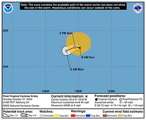
5-Day Uncertainty Track last
updated Sat, 26 Oct 2024 08:35:00 GMT
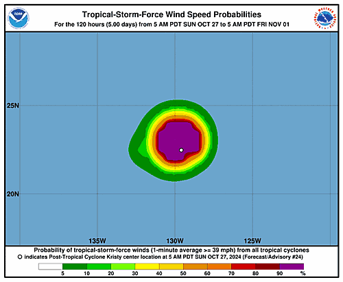
Wind Speed Probabilities last
updated Sat, 26 Oct 2024 09:23:00 GMT
https://www.nhc.noaa.gov/refresh/graphics_ep2+shtml/083500.shtml?cone
date: 2024-10-26, from: Eastern Pacific Basin Tropical Cyclones
000
FOPZ12 KNHC 260834
PWSEP2

HURRICANE KRISTY WIND SPEED PROBABILITIES NUMBER  19
NWS NATIONAL HURRICANE CENTER MIAMI FL       EP122024
0900 UTC SAT OCT 26 2024

AT 0900Z THE CENTER OF HURRICANE KRISTY WAS LOCATED NEAR LATITUDE
18.7 NORTH...LONGITUDE 127.6 WEST WITH MAXIMUM SUSTAINED WINDS NEAR
85 KTS...100 MPH...155 KM/H.

Z INDICATES COORDINATED UNIVERSAL TIME (GREENWICH)
   PACIFIC  DAYLIGHT TIME (PDT)...SUBTRACT 7 HOURS FROM Z TIME
   HAWAIIAN STANDARD TIME (HST)...SUBTRACT 10 HOURS FROM Z TIME

WIND SPEED PROBABILITY TABLE FOR SPECIFIC LOCATIONS

CHANCES OF SUSTAINED (1-MINUTE AVERAGE) WIND SPEEDS OF AT LEAST
   ...34 KT (39 MPH... 63 KM/H)...
   ...50 KT (58 MPH... 93 KM/H)...
   ...64 KT (74 MPH...119 KM/H)...
FOR LOCATIONS AND TIME PERIODS DURING THE NEXT 5 DAYS

PROBABILITIES FOR LOCATIONS ARE GIVEN AS OP(CP) WHERE
    OP  IS THE PROBABILITY OF THE EVENT BEGINNING DURING
        AN INDIVIDUAL TIME PERIOD (ONSET PROBABILITY)
   (CP) IS THE PROBABILITY OF THE EVENT OCCURRING BETWEEN
        06Z SAT AND THE FORECAST HOUR (CUMULATIVE PROBABILITY)

PROBABILITIES ARE GIVEN IN PERCENT
X INDICATES PROBABILITIES LESS THAN 1 PERCENT
PROBABILITIES FOR 34 KT AND 50 KT ARE SHOWN AT A GIVEN LOCATION WHEN
THE 5-DAY CUMULATIVE PROBABILITY IS AT LEAST 3 PERCENT.
PROBABILITIES FOR 34...50...64 KT SHOWN WHEN THE 5-DAY
64-KT CUMULATIVE PROBABILITY IS AT LEAST 1 PERCENT.


  - - - - WIND SPEED PROBABILITIES FOR SELECTED LOCATIONS - - - -

               FROM    FROM    FROM    FROM    FROM    FROM    FROM
  TIME       06Z SAT 18Z SAT 06Z SUN 18Z SUN 06Z MON 06Z TUE 06Z WED
PERIODS         TO      TO      TO      TO      TO      TO      TO
             18Z SAT 06Z SUN 18Z SUN 06Z MON 06Z TUE 06Z WED 06Z THU

FORECAST HOUR    (12)   (24)    (36)    (48)    (72)    (96)   (120)
- - - - - - - - - - - - - - - - - - - - - - - - - - - - - - - - - -
LOCATION       KT

20N 125W       34  3   X( 3)   X( 3)   X( 3)   X( 3)   X( 3)   X( 3)

20N 130W       34 29   7(36)   X(36)   X(36)   X(36)   X(36)   X(36)

25N 130W       34  X   2( 2)   1( 3)   X( 3)   X( 3)   X( 3)   X( 3)

$$
FORECASTER PAPIN
https://www.nhc.noaa.gov/text/refresh/MIAPWSEP2+shtml/260834.shtml
date: 2024-10-26, from: Eastern Pacific Basin Tropical Cyclones
000
WTPZ22 KNHC 260833
TCMEP2

HURRICANE KRISTY FORECAST/ADVISORY NUMBER  19
NWS NATIONAL HURRICANE CENTER MIAMI FL       EP122024
0900 UTC SAT OCT 26 2024

HURRICANE CENTER LOCATED NEAR 18.7N 127.6W AT 26/0900Z
POSITION ACCURATE WITHIN  20 NM

PRESENT MOVEMENT TOWARD THE NORTHWEST OR 320 DEGREES AT  13 KT

ESTIMATED MINIMUM CENTRAL PRESSURE  972 MB
MAX SUSTAINED WINDS  85 KT WITH GUSTS TO 105 KT.
64 KT....... 30NE  20SE  20SW  25NW.
50 KT....... 50NE  40SE  40SW  50NW.
34 KT.......100NE  80SE  70SW 100NW.
12 FT SEAS..180NE 150SE 210SW 180NW.
WINDS AND SEAS VARY GREATLY IN EACH QUADRANT.  RADII IN NAUTICAL
MILES ARE THE LARGEST RADII EXPECTED ANYWHERE IN THAT QUADRANT.

REPEAT...CENTER LOCATED NEAR 18.7N 127.6W AT 26/0900Z
AT 26/0600Z CENTER WAS LOCATED NEAR 18.1N 127.2W

FORECAST VALID 26/1800Z 20.0N 128.5W
MAX WIND  65 KT...GUSTS  80 KT.
64 KT... 20NE  15SE   0SW  20NW.
50 KT... 50NE  30SE  30SW  50NW.
34 KT...100NE  80SE  70SW 100NW.

FORECAST VALID 27/0600Z 21.8N 129.5W
MAX WIND  45 KT...GUSTS  55 KT.
34 KT... 90NE  40SE  50SW 100NW.

FORECAST VALID 27/1800Z 22.6N 130.2W...POST-TROP/REMNT LOW
MAX WIND  30 KT...GUSTS  40 KT.

FORECAST VALID 28/0600Z 22.4N 131.4W...POST-TROP/REMNT LOW
MAX WIND  25 KT...GUSTS  35 KT.

FORECAST VALID 28/1800Z...DISSIPATED

REQUEST FOR 3 HOURLY SHIP REPORTS WITHIN 300 MILES OF 18.7N 127.6W

NEXT ADVISORY AT 26/1500Z

$$
FORECASTER PAPIN=
https://www.nhc.noaa.gov/text/refresh/MIATCMEP2+shtml/260833.shtml
date: 2024-10-26, from: Eastern Pacific Basin GIS Data
…KRISTY CONTINUES TO WEAKEN… …EXPECTED TO BECOME A REMNANT LOW ON SUNDAY… As of 2:00 AM PDT Sat Oct 26 the center of Kristy was located near 18.7, -127.6 with movement NW at 15 mph. The minimum central pressure was 972 mb with maximum sustained winds of about 100 mph.
https://www.nhc.noaa.gov/text/refresh/MIATCPEP2+shtml/260834.shtml
date: 2024-10-26, from: Eastern Pacific Basin GIS Data
Issued at Sat, 26 Oct 2024 08:33:52 GMT. This is only a prototype and the file format may change without notice.
https://www.nhc.noaa.gov/storm_graphics/EP12/atcf-ep122024.xml