(date: 2024-11-10 09:48:03)
date: 2024-11-10, from: Eastern Pacific Basin GIS Data
No tropical cyclones as of Sun, 10 Nov 2024 17:44:15 GMT
date: 2024-11-10, from: NOAA tornado/severe thunderstorm watches, mesoscale discussions, convective outlooks, fire weather outlooks
No watches are valid as of Sun Nov 10 17:31:02 UTC 2024.
https://www.spc.noaa.gov/products/watch/
date: 2024-11-10, from: NOAA tornado/severe thunderstorm watches, mesoscale discussions, convective outlooks, fire weather outlooks
No Mesoscale Discussions are in effect as of Sun Nov 10 17:31:02 UTC 2024.
https://www.spc.noaa.gov/products/md/
date: 2024-11-10, from: NOAA tornado/severe thunderstorm watches, mesoscale discussions, convective outlooks, fire weather outlooks

Day 2 Convective Outlook
NWS Storm Prediction Center Norman OK
1122 AM CST Sun Nov 10 2024

Valid 111200Z - 121200Z

...NO SEVERE THUNDERSTORM AREAS FORECAST...

...SUMMARY...
Thunderstorms will be possible on Monday along parts of the eastern
Gulf Coast, Atlantic Seaboard and in the western states. No severe
threat is expected across the continental U.S. Monday or Monday
night.

...DISCUSSION...
A mid-level trough will move through the eastern U.S. on Monday, as
a cold front advances southeastward into the Mid-Atlantic and
southern Appalachians. Ahead of the front, thunderstorms will be
possible on Monday within a moist airmass across the eastern
Carolinas. Isolated storms may also occur along a sea breeze
boundary in coastal parts of south and east Florida. In addition,
some lighting strikes may occur in the central Gulf Coast, in
association with the outer bands of Tropical Cyclone Rafael. In the
western U.S., thunderstorms may develop on Monday ahead of a
mid-level trough from the Sierras northward into western Oregon and
western Washington. No severe threat is expected across the
continental U.S. Monday and Monday night.

..Broyles.. 11/10/2024
https://www.spc.noaa.gov/products/outlook/day2otlk_1730.html
date: 2024-11-10, from: Central Pacific Basin Tropical Cyclones
000
ACPN50 PHFO 101721
TWOCP
Tropical
Weather Outlook
NWS Central Pacific Hurricane Center Honolulu
HI
800 AM HST Sun Nov 10 2024
For the central North
Pacific…between 140W and 180W:
No tropical cyclones are
expected during the next 7 days.
$$
Forecaster
Tsamous
https://www.nhc.noaa.gov/gtwo.php?basin=cpac
date: 2024-11-10, from: Graphical Tropical Weather Outlooks
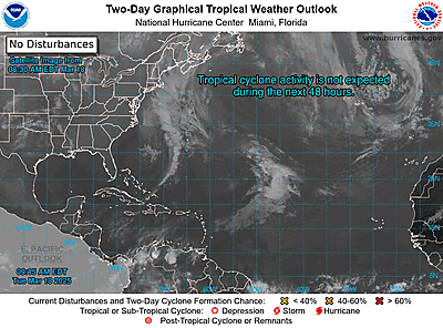
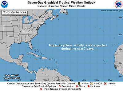
https://www.nhc.noaa.gov/gtwo.php?basin=atlc
date: 2024-11-10, from: Eastern Pacific Basin Tropical Cyclones
000
ABPZ20 KNHC 101714
TWOEP
Tropical
Weather Outlook
NWS National Hurricane Center Miami FL
1000 AM
PST Sun Nov 10 2024
For the eastern North Pacific…east of 140
degrees west longitude:
Tropical cyclone formation is not
expected during the next 7 days.
$$
Forecaster
Hagen
https://www.nhc.noaa.gov/gtwo.php?basin=epac
date: 2024-11-10, from: NOAA tornado/severe thunderstorm watches, mesoscale discussions, convective outlooks, fire weather outlooks

Day 1 Convective Outlook CORR 1
NWS Storm Prediction Center Norman OK
1039 AM CST Sun Nov 10 2024

Valid 101630Z - 111200Z

...NO SEVERE THUNDERSTORM AREAS FORECAST...

CORRECTED TO CHANGE SUNDAY TO MONDAY

...SUMMARY...
The risk for severe thunderstorms appears minimal through tonight.

...Discussion...
An upper low now crossing the Upper Mississippi Valley is forecast
to gradually devolve into an open wave, as it crosses the Upper
Great Lakes region and shifts across the Ottawa River and St.
Lawrence Valleys, and Lower Great Lakes through the end of the
period.  As this occurs, a surface cold front will similarly
progress eastward across the Upper Great Lakes and Midwest region
today, reaching the central and southern Appalachians by 11/12Z
(Monday morning).

Ahead of the front, a relatively moist boundary layer but weak lapse
rates aloft will permit only weak warm-sector instability.  While a
more tropical low-level airmass will reside in the vicinity of the
Lower Mississippi Valley, in part due to east-southeasterly
advection associated with the presence of Tropical Storm Rafael
sitting nearly stationary over the central Gulf, weak shear
precludes appreciable severe potential.  Farther north, stronger
flow aloft will be offset by lower theta-e/weak CAPE as compared to
areas farther south.  As such, severe weather is not anticipated.

..Goss/Lyons.. 11/10/2024
https://www.spc.noaa.gov/products/outlook/day1otlk_1630.html
date: 2024-11-10, from: NOAA tornado/severe thunderstorm watches, mesoscale discussions, convective outlooks, fire weather outlooks

Day 1 Fire Weather Outlook
NWS Storm Prediction Center Norman OK
0929 AM CST Sun Nov 10 2024

Valid 101700Z - 111200Z

Elevated conditions are likely from northern New Jersey and far
northeast Pennsylvania to southern New England late this morning
into the afternoon before showers arrive as a warm front lifts
northward through the Northeast. Locally elevated conditions are
already developing in parts of Upstate New York and northeast
Pennsylvania ahead of the increasing cloud cover and showers. While
marginally elevated conditions are expected in a relatively narrow
temporal window, the ongoing drought and record high fire danger in
the region led to the issuance.

..Nauslar.. 11/10/2024

.PREV DISCUSSION... /ISSUED 1218 AM CST Sun Nov 10 2024/

...Synopsis...
Fire weather concerns are expected to be minimal today across the
CONUS. A trough will traverse the Great Lakes region, with cooler
and wetter conditions extending from the Upper Midwest into the Ohio
River Valley and up to the Northeast. Cooler post-frontal conditions
will extend across much of the Plains. Some briefly Elevated
conditions are possible in the Northeast ahead of the approaching
front, but wetting rainfall will be expected by the afternoon.
Lingering dry conditions will be possible across southern
California, but generally light winds will keep fire concerns low.

...Please see www.spc.noaa.gov/fire for graphic product...
https://www.spc.noaa.gov/products/fire_wx/fwdy1.html
date: 2024-11-08, from: NOAA tornado/severe thunderstorm watches, mesoscale discussions, convective outlooks, fire weather outlooks
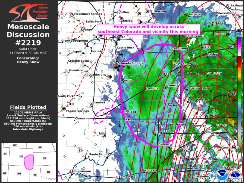
Mesoscale Discussion 2219
NWS Storm Prediction Center Norman OK
0623 AM CST Fri Nov 08 2024

Areas affected...southeast Colorado...far northeast New Mexico...and
the western OK Panhandle.

Concerning...Heavy snow

Valid 081223Z - 081630Z

SUMMARY...Heavy snow will develop across southeast Colorado and
vicinity this morning.

DISCUSSION...An upper-level low across New Mexico has started to
become negatively tilted this morning. As this has occurred, a broad
region of ascent has overspread the southern Plains, evidenced by
widespread lightning activity. In addition, strong frontogenesis
across the Texas Panhandle has resulted in a more focused region of
ascent. The heavier precipitation associated with this enhanced area
of UVV will migrate northwestward into the cold airmass across
southeast Colorado over the next few hours. In addition, a easterly
low-level jet, currently around 35 knots (per DDC VWP) and expected
to strengthen to around 45 knots, will result in strengthening
isentropic ascent. The combination of these factors will result in a
favorable region across southeast Colorado and vicinity with
snowfall rates of 1 to 2 inches per hour, likely starting between
13Z and 14Z.

..Bentley.. 11/08/2024

...Please see www.spc.noaa.gov for graphic product...

ATTN...WFO...DDC...GLD...AMA...PUB...BOU...ABQ...

LAT...LON   36440403 37140450 38360471 38920453 39550311 39530235
            39220194 38040196 36830208 36290236 36020315 36440403
https://www.spc.noaa.gov/products/md/md2219.html
date: 2024-11-08, from: NOAA tornado/severe thunderstorm watches, mesoscale discussions, convective outlooks, fire weather outlooks

Day 1 Convective Outlook
NWS Storm Prediction Center Norman OK
0652 AM CST Fri Nov 08 2024

Valid 081300Z - 091200Z

...THERE IS A SLIGHT RISK OF SEVERE THUNDERSTORMS OVER NORTH-CENTRAL
TEXAS...

...SUMMARY...
Severe-thunderstorm threat exists from north Texas to the Hill
Country and parts of central/east Texas through this evening.  The
most focused tornado, damaging-wind and hail potential appears to be
over north-central Texas.

...Synopsis...
The mid/upper-level pattern features a closed, temporarily cut-off,
synoptic-scale cyclone, initially centered over central NM.  As a
strong, basal shortwave trough pivots northeastward across eastern
NM and the TX Panhandle today, the 500-mb low will shift east-
northeastward toward CAO by 00Z.  Overnight, the low should track
north-northeastward, reaching the GLD vicinity by 12Z.  Height falls
should occur over central/north TX today, then becoming neutral to
slightly rising overnight.

The 11Z surface analysis showed a frontal-wave low near SWW, with a
cold front south-southwestward between DRT-6R6.  A warm front was
drawn from the low through some rain-cooled air to near MWL, then
east-southeastward over southern fringes of the Metroplex to between
LFK-ESF.  The low is expected to move northward to near the
northeastern corner of the TX Panhandle by 00Z and occlude, while
the occluded/cold front reaches western OK, north-central/central
TX, to near LRD.  The warm front should drift northward over north-
central/northeast TX, with its progress slowed by increasing
precip/convection to its north.  By 12Z tomorrow, the low should get
stacked with the 500-mb center over northwestern KS, with the cold
front reaching east TX and the shelf waters off the TX Gulf Coast.

Meanwhile, Hurricane Rafael is forecast to remain well-removed from
land this period, moving generally westward over the central to
west-central Gulf then slowing/meandering after this period.  See
NHC advisories for latest forecast track/intensity info on Rafael.

...North to central TX...
An ongoing area of convection over parts of north TX and southern OK
is expected to shift northward over increasingly elevated and less-
unstable inflow parcels and weaken through midday.  Meanwhile,
closer to the cold front, scattered thunderstorms are expected to
develop over the next several hours through early afternoon,
evolving into a nearly solid convective band with embedded
supercells and bow/LEWP formations possible.  This activity should
shift eastward over central and north TX through early evening,
offering at least marginal potential for all severe hazards.

Meanwhile, isolated to scattered thunderstorms are possible in the
warm sector and along/north of the warm front.  This activity should
move northward to northeastward.  Any sustained, relatively discrete
cells with prolonged access to surface-based parcels in the warm
sector, and especially interacting with the warm front, may rotate
with a threat for all hazards (hail, damaging to severe gusts and
mesoscale peak in tornado potential) also present.  The associated
theta-e/instability gradient is expected to align northwest/
southeast very near or even across the DFW Metroplex.  This will
yield an increased severe threat from north to south into more-
unstable inflow air, and within the southern part of the relatively
high-vorticity gradient itself.  Given the superposition of these
foci and the expected favorable parameter space, the north-central
TX part of the outlook is being upgraded for all hazards this cycle.

Upper 60s to low 70s F surface dewpoints already are present in the
warm sector, and will shift north slowly, in step with the warm
front, before the main north-south band overtakes the region.  This
should occur during the afternoon when low-level, warm-sector
instability is maximized away from convection.  Despite modest lapse
rates aloft (manifest in mid/upper-level stable layers sampled by
the 12Z FWD sounding), a northwestward-narrowing, triangular
corridor of 1000-1500 J/kg peak MLCAPE is expected.  Veering winds
with height are forecast to continue, with hodograph curvature/size
largest along the warm front, and enough deep shear (effective-shear
magnitudes 35-45 kt in central/north TX, weakening southward and
eastward) to support occasional supercell structures.  Overnight,
supportive large-scale ascent and the elevated LLJ each should shift
northward away from the area, while the main band of convective-
scale forcing shifts into east TX and weakens.

..Edwards/Bentley.. 11/08/2024
https://www.spc.noaa.gov/products/outlook/day1otlk_1300.html
date: 2024-11-08, from: NOAA Weather Forecasts
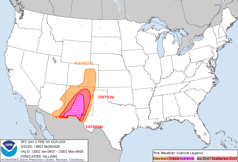
Day 2 Fire Weather Outlook
NWS Storm Prediction Center Norman OK
0143 AM CST Fri Nov 08 2024

Valid 091200Z - 101200Z

...NO CRITICAL AREAS...

...Synopsis...
Fire weather concerns will be low across the CONUS on Saturday. A
deepening trough will bring widespread rain across much of the
central/southern Plains. Elsewhere, dry conditions will continue
across southern California and across portions of New England. Both
of these regions will be under building high pressure, keeping winds
mostly light and fire concerns low.

..Thornton.. 11/08/2024

...Please see www.spc.noaa.gov/fire for graphic product...
https://www.spc.noaa.gov/products/fire_wx/fwdy2.html
date: 2024-11-07, from: NOAA tornado/severe thunderstorm watches, mesoscale discussions, convective outlooks, fire weather outlooks

Mesoscale Discussion 2215
NWS Storm Prediction Center Norman OK
0706 AM CST Thu Nov 07 2024

Areas affected...Northeast NM...Extreme Northwest TX Panhandle...Far
Western OK Panhandle...Southeast CO

Concerning...Heavy snow

Valid 071306Z - 071700Z

SUMMARY...Moderate to occasionally heavy snowfall (i.e. rates
exceeding 1"/hr.) are expected to persist across northeastern NM and
eastern CO, and into adjacent portions of western KS and the western
TX/OK Panhandle through the morning.

DISCUSSION...Recent satellite imagery shows a notable baroclinic
leaf across northeast NM and eastern CO, downstream of a deep upper
low centered over AZ. This synoptic pattern is favoring strong
mid-level warm-air advection across the warm sector of this cyclone,
contributing to a broad area of precipitation across much of
central/eastern NM and eastern CO, and into adjacent portions of
western KS and the western TX/OK Panhandles. Thermodynamic profiles
from east-central NM northward are cold enough for snow, and recent
observations suggest moderate to occasionally heavy snow is ongoing
across the region. The upper low is expected to drift slowly
eastward throughout the day. With the slow motion of will keep much
of this region in a favorable location for continued moderate to
heavy snow, with snowfall rates occasionally topping 1" per hour
across the lower elevations. The mid-level warm-air advection is
currently maximized across northeast NM, suggesting the heaviest
snowfall is most likely across southeast CO for the next few hours.

..Mosier.. 11/07/2024

...Please see www.spc.noaa.gov for graphic product...

ATTN...WFO...GLD...AMA...PUB...BOU...ABQ...

LAT...LON   37950413 39090394 39290264 38250206 36540236 35730337
            35760453 37950413
https://www.spc.noaa.gov/products/md/md2215.html
date: 2024-11-07, from: Eastern Pacific Basin GIS Data
Shapefile last updated Thu, 07 Nov 2024 15:23:31 GMT
https://www.nhc.noaa.gov/gis/forecast/archive/wsp_120hrhalfDeg_latest.zip
date: 2024-11-07, from: Eastern Pacific Basin GIS Data
KMZ last updated Thu, 07 Nov 2024 14:51:42 GMT
https://www.nhc.noaa.gov/storm_graphics/api/EP142024_005adv_TRACK.kmz
date: 2024-11-07, from: Eastern Pacific Basin GIS Data
Initial and Forecast Surface Winds. Shapefile last updated Thu, 07 Nov 2024 14:51:16 GMT
https://www.nhc.noaa.gov/gis/forecast/archive/ep142024_fcst_005.zip
date: 2024-11-07, from: Eastern Pacific Basin GIS Data
Track, Points, and Wind Swath. Shapefile last updated Thu, 07 Nov 2024 14:51:07 GMT
https://www.nhc.noaa.gov/gis/best_track/ep142024_best_track.zip
date: 2024-11-07, from: Eastern Pacific Basin GIS Data
KMZ last updated Thu, 07 Nov 2024 14:51:07 GMT
https://www.nhc.noaa.gov/gis/best_track/ep142024_best_track.kmz
date: 2024-11-07, from: Eastern Pacific Basin GIS Data
KMZ last updated Thu, 07 Nov 2024 14:51:06 GMT
https://www.nhc.noaa.gov/storm_graphics/api/EP142024_005adv_CONE.kmz
date: 2024-11-07, from: Eastern Pacific Basin GIS Data
Forecast Track, Cone of Uncertainty, Watches/Warnings. Shapefile last updated Thu, 07 Nov 2024 14:50:58 GMT
https://www.nhc.noaa.gov/gis/forecast/archive/ep142024_5day_005.zip
date: 2024-11-07, from: Eastern Pacific Basin Tropical Cyclones
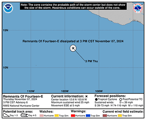
5-Day Uncertainty Track last
updated Thu, 07 Nov 2024 14:50:32 GMT
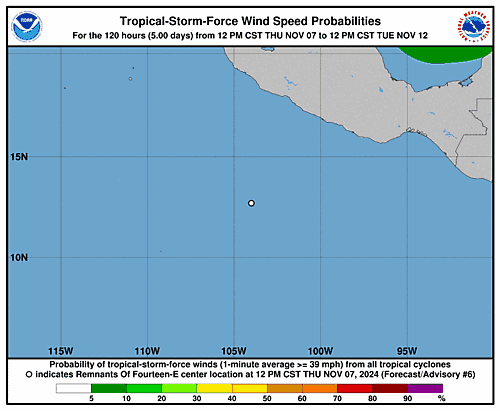
Wind Speed Probabilities last
updated Thu, 07 Nov 2024 15:28:57 GMT
https://www.nhc.noaa.gov/refresh/graphics_ep4+shtml/145032.shtml?cone
date: 2024-11-07, from: Eastern Pacific Basin Tropical Cyclones
000
WTPZ44 KNHC 071449
TCDEP4

Tropical Depression Fourteen-E Discussion Number   5
NWS National Hurricane Center Miami FL       EP142024
900 AM CST Thu Nov 07 2024

The depression is once again struggling to produce deep organized
convection.  Thunderstorms from the diurnal maximum overnight have
dissipated, and the low-level center is nearing an area of
convection not associated with the depression.  Furthermore, the
outflow boundaries from the adjacent thunderstorms seem to be
disrupting the low-level circulation.  The TAFB Dvorak Final-T has
also trended downward to T1.5, reflecting the decaying convective
organization. The initial intensity is held at a possibly generous
25 kt for this advisory.

Environmental conditions should remain marginal to hostile and
prevent further strengthening.  Global models continue to predict
that the depression should open into a trough within a day, though
it is possible this has already occurred.  The latest official
intensity forecast still shows dissipation occurring by Friday.

The depression is moving at an uncertain 110/4 kt.  The low-level
flow is expected to turn the depression to the southeast soon.  The
NHC track position is near the corrected consensus aid, HCCA.


FORECAST POSITIONS AND MAX WINDS

INIT  07/1500Z 13.2N 104.4W   25 KT  30 MPH
 12H  08/0000Z 12.3N 103.7W   25 KT  30 MPH
 24H  08/1200Z...DISSIPATED

$$
Forecaster Bucci
https://www.nhc.noaa.gov/text/refresh/MIATCDEP4+shtml/071449.shtml
date: 2024-11-07, from: Eastern Pacific Basin Tropical Cyclones
000
WTPZ34 KNHC 071448
TCPEP4

BULLETIN
Tropical Depression Fourteen-E Advisory Number   5
NWS National Hurricane Center Miami FL       EP142024
900 AM CST Thu Nov 07 2024

...DEPRESSION UNRAVELING...


SUMMARY OF 900 AM CST...1500 UTC...INFORMATION
----------------------------------------------
LOCATION...13.2N 104.4W
ABOUT 395 MI...635 KM SW OF ACAPULCO MEXICO
MAXIMUM SUSTAINED WINDS...30 MPH...45 KM/H
PRESENT MOVEMENT...ESE OR 110 DEGREES AT 5 MPH...7 KM/H
MINIMUM CENTRAL PRESSURE...1007 MB...29.74 INCHES


WATCHES AND WARNINGS
--------------------
There are no coastal watches or warnings in effect.


DISCUSSION AND OUTLOOK
----------------------
At 900 AM CST (1500 UTC), the center of Tropical Depression
Fourteen-E was located near latitude 13.2 North, longitude 104.4
West. The depression is moving toward the east-southeast near 5 mph
(7 km/h). A slightly faster southeastward motion is expected later
today.

Maximum sustained winds are near 30 mph (45 km/h) with higher gusts.
The depression is forecast to dissipate on Friday, although that
could occur sooner.

The estimated minimum central pressure is 1007 mb (29.74 inches).


HAZARDS AFFECTING LAND
----------------------
None.


NEXT ADVISORY
-------------
Next complete advisory at 300 PM CST.

$$
Forecaster Bucci
https://www.nhc.noaa.gov/text/refresh/MIATCPEP4+shtml/071448.shtml
date: 2024-11-07, from: Eastern Pacific Basin Tropical Cyclones
000
FOPZ14 KNHC 071448
PWSEP4

TROPICAL DEPRESSION FOURTEEN-E WIND SPEED PROBABILITIES NUMBER   5
NWS NATIONAL HURRICANE CENTER MIAMI FL       EP142024
1500 UTC THU NOV 07 2024

AT 1500Z THE CENTER OF TROPICAL DEPRESSION FOURTEEN-E WAS LOCATED
NEAR LATITUDE 13.2 NORTH...LONGITUDE 104.4 WEST WITH MAXIMUM
SUSTAINED WINDS NEAR 25 KTS...30 MPH...45 KM/H.

Z INDICATES COORDINATED UNIVERSAL TIME (GREENWICH)
   PACIFIC  STANDARD TIME (PST)...SUBTRACT 8 HOURS FROM Z TIME
   HAWAIIAN STANDARD TIME (HST)...SUBTRACT 10 HOURS FROM Z TIME

WIND SPEED PROBABILITY TABLE FOR SPECIFIC LOCATIONS

CHANCES OF SUSTAINED (1-MINUTE AVERAGE) WIND SPEEDS OF AT LEAST
   ...34 KT (39 MPH... 63 KM/H)...
   ...50 KT (58 MPH... 93 KM/H)...
   ...64 KT (74 MPH...119 KM/H)...
FOR LOCATIONS AND TIME PERIODS DURING THE NEXT 5 DAYS

PROBABILITIES FOR LOCATIONS ARE GIVEN AS OP(CP) WHERE
    OP  IS THE PROBABILITY OF THE EVENT BEGINNING DURING
        AN INDIVIDUAL TIME PERIOD (ONSET PROBABILITY)
   (CP) IS THE PROBABILITY OF THE EVENT OCCURRING BETWEEN
        12Z THU AND THE FORECAST HOUR (CUMULATIVE PROBABILITY)

PROBABILITIES ARE GIVEN IN PERCENT
X INDICATES PROBABILITIES LESS THAN 1 PERCENT
PROBABILITIES FOR 34 KT AND 50 KT ARE SHOWN AT A GIVEN LOCATION WHEN
THE 5-DAY CUMULATIVE PROBABILITY IS AT LEAST 3 PERCENT.
PROBABILITIES FOR 34...50...64 KT SHOWN WHEN THE 5-DAY
64-KT CUMULATIVE PROBABILITY IS AT LEAST 1 PERCENT.


  - - - - WIND SPEED PROBABILITIES FOR SELECTED LOCATIONS - - - -

               FROM    FROM    FROM    FROM    FROM    FROM    FROM
  TIME       12Z THU 00Z FRI 12Z FRI 00Z SAT 12Z SAT 12Z SUN 12Z MON
PERIODS         TO      TO      TO      TO      TO      TO      TO
             00Z FRI 12Z FRI 00Z SAT 12Z SAT 12Z SUN 12Z MON 12Z TUE

FORECAST HOUR    (12)   (24)    (36)    (48)    (72)    (96)   (120)
- - - - - - - - - - - - - - - - - - - - - - - - - - - - - - - - - -
LOCATION       KT

$$
FORECASTER BUCCI
https://www.nhc.noaa.gov/text/refresh/MIAPWSEP4+shtml/071448.shtml
date: 2024-11-07, from: Eastern Pacific Basin Tropical Cyclones
000
WTPZ24 KNHC 071448
TCMEP4

TROPICAL DEPRESSION FOURTEEN-E FORECAST/ADVISORY NUMBER   5
NWS NATIONAL HURRICANE CENTER MIAMI FL       EP142024
1500 UTC THU NOV 07 2024

TROPICAL DEPRESSION CENTER LOCATED NEAR 13.2N 104.4W AT 07/1500Z
POSITION ACCURATE WITHIN  20 NM

PRESENT MOVEMENT TOWARD THE EAST-SOUTHEAST OR 110 DEGREES AT   4 KT

ESTIMATED MINIMUM CENTRAL PRESSURE 1007 MB
MAX SUSTAINED WINDS  25 KT WITH GUSTS TO  35 KT.
WINDS AND SEAS VARY GREATLY IN EACH QUADRANT.  RADII IN NAUTICAL
MILES ARE THE LARGEST RADII EXPECTED ANYWHERE IN THAT QUADRANT.

REPEAT...CENTER LOCATED NEAR 13.2N 104.4W AT 07/1500Z
AT 07/1200Z CENTER WAS LOCATED NEAR 13.4N 104.6W

FORECAST VALID 08/0000Z 12.3N 103.7W
MAX WIND  25 KT...GUSTS  35 KT.

FORECAST VALID 08/1200Z...DISSIPATED

REQUEST FOR 3 HOURLY SHIP REPORTS WITHIN 300 MILES OF 13.2N 104.4W

NEXT ADVISORY AT 07/2100Z

$$
FORECASTER BUCCI
https://www.nhc.noaa.gov/text/refresh/MIATCMEP4+shtml/071448.shtml
date: 2024-11-07, from: Eastern Pacific Basin GIS Data
Issued at Thu, 07 Nov 2024 14:48:16 GMT. This is only a prototype and the file format may change without notice.
https://www.nhc.noaa.gov/storm_graphics/EP14/atcf-ep142024.xml
date: 2024-11-06, from: Eastern Pacific Basin GIS Data
KMZ last updated Wed, 06 Nov 2024 14:58:48 GMT
https://www.nhc.noaa.gov/storm_graphics/api/EP142024_001adv_TRACK.kmz
date: 2024-11-06, from: Eastern Pacific Basin GIS Data
Initial and Forecast Surface Winds. Shapefile last updated Wed, 06 Nov 2024 14:58:32 GMT
https://www.nhc.noaa.gov/gis/forecast/archive/ep142024_fcst_001.zip
date: 2024-11-06, from: Eastern Pacific Basin GIS Data
KMZ last updated Wed, 06 Nov 2024 14:58:16 GMT
https://www.nhc.noaa.gov/storm_graphics/api/EP142024_001adv_CONE.kmz
date: 2024-11-06, from: Eastern Pacific Basin GIS Data
Forecast Track, Cone of Uncertainty, Watches/Warnings. Shapefile last updated Wed, 06 Nov 2024 14:58:09 GMT
https://www.nhc.noaa.gov/gis/forecast/archive/ep142024_5day_001.zip
date: 2024-11-06, from: Eastern Pacific Basin Tropical Cyclones

5-Day Uncertainty Track last
updated Wed, 06 Nov 2024 14:57:45 GMT

Wind Speed Probabilities last
updated Wed, 06 Nov 2024 15:30:25 GMT
https://www.nhc.noaa.gov/refresh/graphics_ep4+shtml/145745.shtml?cone
date: 2024-11-06, from: Eastern Pacific Basin Tropical Cyclones
000
WTPZ44 KNHC 061453
TCDEP4

Tropical Depression Fourteen-E Discussion Number   1
NWS National Hurricane Center Miami FL       EP142024
800 AM MST Wed Nov 06 2024

The National Hurricane Center has been tracking a well-defined low
pressure system located several hundred miles southwest of the
southwestern Mexican coast.  Beginning around 2300 UTC on Tuesday,
deep convection formed over the low-level circulation and cold cloud
tops have persisted for over 15 hours.  TAFB has classified this
system with a T2.0, indicating that is has reached the necessary
requirements of maintaining deep, organized convection.  Therefore,
the system is being designated as Tropical Depression Fourteen-E and
the initial intensity is set to 30 kt.  Scatterometer data is
expected later today which should provide a better intensity
estimate.

The depression is drifting northeastward at 3 kt.  A narrow
mid-level ridge is building to the north of the cyclone and expected
to turn the depression eastward later today.  The system should
briefly accelerate and turn more east-southeastward to southeastward
on Thursday before drifting back to the east-southeast on Friday in
the low-level flow.  The NHC track forecast lies between the simple
and corrected consensus aids.

Surrounding dry mid-level humidities and moderate vertical wind
shear seem to be the limiting factors preventing the depression from
any significant strengthening.  Global models indicate there should
be a brief period in about day or so that the deep-layer vertical
wind shear should relax slightly and possibly allow for a little
strengthening.  The depression is expected to lose its organized
deep convection over the weekend and open into a trough.  However,
there is a possibility this occurs sooner.


FORECAST POSITIONS AND MAX WINDS

INIT  06/1500Z 13.1N 106.1W   30 KT  35 MPH
 12H  07/0000Z 13.1N 105.4W   30 KT  35 MPH
 24H  07/1200Z 12.5N 104.4W   35 KT  40 MPH
 36H  08/0000Z 11.3N 103.7W   35 KT  40 MPH
 48H  08/1200Z 10.6N 103.2W   30 KT  35 MPH
 60H  09/0000Z 10.2N 102.6W   30 KT  35 MPH
 72H  09/1200Z 10.1N 102.1W   25 KT  30 MPH...POST-TROPICAL
 96H  10/1200Z...DISSIPATED

$$
Forecaster Bucci
https://www.nhc.noaa.gov/text/refresh/MIATCDEP4+shtml/061453.shtml
date: 2024-11-06, from: Eastern Pacific Basin Tropical Cyclones
000
FOPZ14 KNHC 061452
PWSEP4

TROPICAL DEPRESSION FOURTEEN-E WIND SPEED PROBABILITIES NUMBER   1
NWS NATIONAL HURRICANE CENTER MIAMI FL       EP142024
1500 UTC WED NOV 06 2024

AT 1500Z THE CENTER OF TROPICAL DEPRESSION FOURTEEN-E WAS LOCATED
NEAR LATITUDE 13.1 NORTH...LONGITUDE 106.1 WEST WITH MAXIMUM
SUSTAINED WINDS NEAR 30 KTS...35 MPH...55 KM/H.

Z INDICATES COORDINATED UNIVERSAL TIME (GREENWICH)
   PACIFIC  STANDARD TIME (PST)...SUBTRACT 8 HOURS FROM Z TIME
   HAWAIIAN STANDARD TIME (HST)...SUBTRACT 10 HOURS FROM Z TIME

WIND SPEED PROBABILITY TABLE FOR SPECIFIC LOCATIONS

CHANCES OF SUSTAINED (1-MINUTE AVERAGE) WIND SPEEDS OF AT LEAST
   ...34 KT (39 MPH... 63 KM/H)...
   ...50 KT (58 MPH... 93 KM/H)...
   ...64 KT (74 MPH...119 KM/H)...
FOR LOCATIONS AND TIME PERIODS DURING THE NEXT 5 DAYS

PROBABILITIES FOR LOCATIONS ARE GIVEN AS OP(CP) WHERE
    OP  IS THE PROBABILITY OF THE EVENT BEGINNING DURING
        AN INDIVIDUAL TIME PERIOD (ONSET PROBABILITY)
   (CP) IS THE PROBABILITY OF THE EVENT OCCURRING BETWEEN
        12Z WED AND THE FORECAST HOUR (CUMULATIVE PROBABILITY)

PROBABILITIES ARE GIVEN IN PERCENT
X INDICATES PROBABILITIES LESS THAN 1 PERCENT
PROBABILITIES FOR 34 KT AND 50 KT ARE SHOWN AT A GIVEN LOCATION WHEN
THE 5-DAY CUMULATIVE PROBABILITY IS AT LEAST 3 PERCENT.
PROBABILITIES FOR 34...50...64 KT SHOWN WHEN THE 5-DAY
64-KT CUMULATIVE PROBABILITY IS AT LEAST 1 PERCENT.


  - - - - WIND SPEED PROBABILITIES FOR SELECTED LOCATIONS - - - -

               FROM    FROM    FROM    FROM    FROM    FROM    FROM
  TIME       12Z WED 00Z THU 12Z THU 00Z FRI 12Z FRI 12Z SAT 12Z SUN
PERIODS         TO      TO      TO      TO      TO      TO      TO
             00Z THU 12Z THU 00Z FRI 12Z FRI 12Z SAT 12Z SUN 12Z MON

FORECAST HOUR    (12)   (24)    (36)    (48)    (72)    (96)   (120)
- - - - - - - - - - - - - - - - - - - - - - - - - - - - - - - - - -
LOCATION       KT

10N 105W       34  X   1( 1)   3( 4)   1( 5)   1( 6)   X( 6)   X( 6)

$$
FORECASTER BUCCI
https://www.nhc.noaa.gov/text/refresh/MIAPWSEP4+shtml/061452.shtml
date: 2024-11-06, from: Eastern Pacific Basin GIS Data
…TROPICAL DEPRESSION FORMS OVER THE EASTERN PACIFIC… As of 8:00 AM MST Wed Nov 6 the center of Fourteen-E was located near 13.1, -106.1 with movement NE at 3 mph. The minimum central pressure was 1006 mb with maximum sustained winds of about 35 mph.
https://www.nhc.noaa.gov/text/refresh/MIATCPEP4+shtml/061452.shtml
date: 2024-11-06, from: Eastern Pacific Basin Tropical Cyclones
000
WTPZ24 KNHC 061452
TCMEP4

TROPICAL DEPRESSION FOURTEEN-E FORECAST/ADVISORY NUMBER   1
NWS NATIONAL HURRICANE CENTER MIAMI FL       EP142024
1500 UTC WED NOV 06 2024

TROPICAL DEPRESSION CENTER LOCATED NEAR 13.1N 106.1W AT 06/1500Z
POSITION ACCURATE WITHIN  30 NM

PRESENT MOVEMENT TOWARD THE NORTHEAST OR  45 DEGREES AT   3 KT

ESTIMATED MINIMUM CENTRAL PRESSURE 1006 MB
MAX SUSTAINED WINDS  30 KT WITH GUSTS TO  40 KT.
WINDS AND SEAS VARY GREATLY IN EACH QUADRANT.  RADII IN NAUTICAL
MILES ARE THE LARGEST RADII EXPECTED ANYWHERE IN THAT QUADRANT.

REPEAT...CENTER LOCATED NEAR 13.1N 106.1W AT 06/1500Z
AT 06/1200Z CENTER WAS LOCATED NEAR 13.1N 106.4W

FORECAST VALID 07/0000Z 13.1N 105.4W
MAX WIND  30 KT...GUSTS  40 KT.

FORECAST VALID 07/1200Z 12.5N 104.4W
MAX WIND  35 KT...GUSTS  45 KT.
34 KT...  0NE  50SE   0SW   0NW.

FORECAST VALID 08/0000Z 11.3N 103.7W
MAX WIND  35 KT...GUSTS  45 KT.
34 KT...  0NE  50SE   0SW   0NW.

FORECAST VALID 08/1200Z 10.6N 103.2W
MAX WIND  30 KT...GUSTS  40 KT.

FORECAST VALID 09/0000Z 10.2N 102.6W
MAX WIND  30 KT...GUSTS  40 KT.

FORECAST VALID 09/1200Z 10.1N 102.1W...POST-TROPICAL
MAX WIND  25 KT...GUSTS  35 KT.

EXTENDED OUTLOOK. NOTE...ERRORS FOR TRACK HAVE AVERAGED NEAR 100 NM
ON DAY 4 AND 125 NM ON DAY 5...AND FOR INTENSITY NEAR 15 KT EACH DAY

OUTLOOK VALID 10/1200Z...DISSIPATED

REQUEST FOR 3 HOURLY SHIP REPORTS WITHIN 300 MILES OF 13.1N 106.1W

NEXT ADVISORY AT 06/2100Z

$$
FORECASTER BUCCI
https://www.nhc.noaa.gov/text/refresh/MIATCMEP4+shtml/061452.shtml
date: 2024-11-05, from: NOAA tornado/severe thunderstorm watches, mesoscale discussions, convective outlooks, fire weather outlooks
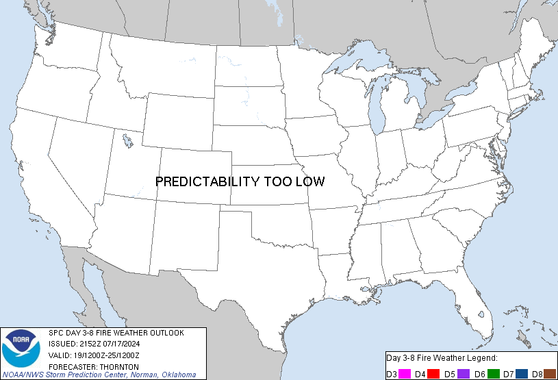
Day 3-8 Fire Weather Outlook
NWS Storm Prediction Center Norman OK
0354 PM CST Tue Nov 05 2024

Valid 071200Z - 131200Z

An active mid-level flow regime is likely to continue over the CONUS
through the extended forecast period. Strong troughing over the
western US will gradually shift eastward this weekend, followed by
shortwave ridging. By early next week, the upper ridge will break
down, allowing stronger jet energy to move back over the West ahead
of a deepening Pacific trough. This active and progressive flow
pattern will continue through the end of the period, supporting the
potential for critical fire-weather over parts of California.

...Southern California...
On the backside of the strong trough, northerly flow will linger
over southern California D3/Thursday into early D4/Friday. Offshore
winds will remain fairly strong early in the period before weakening
rapidly into this weekend. As the winds gradually fade, very low
humidity should persist into the first part of the weekend. This may
keep some risk for localized fire-weather concerns through D6/Sunday
across parts of southern California.

Later in the weekend and into early next week,  onshore flow will
return, increasing RH as a progressive, low-latitude flow regime
persists. Fire-weather concerns will lessen temporarily before
potentially returning ahead of another deepening trough midweek next
week. Medium-range guidance shows the potential for a period of
offshore winds behind the large Pacific trough into week 2. Strong
winds and very low relative humidity could overlap with very dry and
dense fuels across much of southern California. Model guidance
varies enough on the magnitude and timing of the onset of offshore
winds that probabilities will be withheld for the time being.
However, significant fire-weather concerns are possible at the end
of the extended forecast period and through next week.

..Lyons.. 11/05/2024

...Please see www.spc.noaa.gov/fire for graphic product...
https://www.spc.noaa.gov/products/exper/fire_wx/
date: 2024-11-05, from: NOAA tornado/severe thunderstorm watches, mesoscale discussions, convective outlooks, fire weather outlooks

Day 1 Convective Outlook
NWS Storm Prediction Center Norman OK
0157 PM CST Tue Nov 05 2024

Valid 052000Z - 061200Z

...THERE IS A MARGINAL RISK OF SEVERE THUNDERSTORMS IN PORTIONS OF
SOUTHERN WISCONSIN AND FROM THE LOWER OHIO VALLEY INTO THE LOWER
MISSISSIPPI VALLEY...

...SUMMARY...
Locally damaging winds and perhaps a tornado or two may occur across
a portion of the Lower and Mid Mississippi Valleys, and central to
southern Wisconsin.

...20Z Update...
With the primary mid-level forcing moving away from the ArkLaMiss,
storm coverage should generally remain more isolated through the
remainder of the afternoon. Furthermore, regional VAD profiles
suggest low-level shear have been decreasing with time. Given these
observational trends, tornado probabilities have been reduced in the
region.

The marginal risk across Wisconsin has been adjusted based on
surface observations. A line of shallow convection moving east
through western Wisconsin may produce isolated strong/damaging winds
as it moves into areas where at least muted heating has occurred.
KMKX VAD suggests strong enough flow in the lowest 1-2 km to support
this risk.

..Wendt.. 11/05/2024

.PREV DISCUSSION... /ISSUED 1019 AM CST Tue Nov 05 2024/

...LA/MS...
A large upper trough is present today over the central US, with the
primary surface boundary extending from eastern AR southward into
central LA.  Scattered thunderstorms have been occurring along and
ahead of this boundary, including several storms exhibiting low and
mid level rotation.  Winds aloft are expected to weaken through the
day, but there is a continued chance of isolated tornadoes for a few
hours late this morning and early afternoon.  Therefore have added a
small SLGT risk area.  Please refer to MCD #2213 for further details
on this environment.

...AR/TN/KY/IN...
A narrow line of thunderstorms is noted along the boundary across
eastern AR.  Several morning CAM solutions suggest this line may
maintain some character through the afternoon and it tracks
northeastward across parts of the mid MS Valley.  Visible satellite
imagery shows breaks in the clouds across this region, providing
some heating and destabilization.  Also, low level wind fields will
remain rather strong ahead of the convection.  This may be
sufficient for locally gusty/damaging wind gusts this afternoon.

....WI...
A few low-topped showers and thunderstorms will likely form later
this afternoon near a deepening surface low over WI.  Widespread
clouds will limit destabilization, but there is some potential for
locally gusty/damaging winds during the peak-heating period.
https://www.spc.noaa.gov/products/outlook/day1otlk_2000.html
date: 2024-11-05, from: NOAA tornado/severe thunderstorm watches, mesoscale discussions, convective outlooks, fire weather outlooks

Day 3 Convective Outlook
NWS Storm Prediction Center Norman OK
0125 PM CST Tue Nov 05 2024

Valid 071200Z - 081200Z

...THERE IS A MARGINAL RISK OF SEVERE THUNDERSTORMS IN PARTS OF
CENTRAL/WEST-CENTRAL TEXAS...

...SUMMARY...
Isolated severe thunderstorms are possible, beginning Thursday
afternoon across central/west-central parts of Texas.

...TX...
A mid- to upper-level low will meander slowly east across the Desert
Southwest during the period.  In between a surface high centered
over the central High Plains and TC Rafael in the Gulf of Mexico,
easterly low-level flow in the western Gulf Basin and TX will favor
a gradual westward push of modified moisture return into
west-central TX.  A surface trough will likely serve as the western
delimiter of moisture/instability.  Models indicate at least weak to
moderate buoyancy developing by mid-late afternoon in the Concho
Valley.  Shear profiles will support storm organization, including
the possibility for supercells.  Have made a small westward
adjustment to low-severe probabilities over west-central TX based on
the latest model guidance.  Large hail appears to be the primary
threat, although a confined zone may exhibit a short-duration threat
for a tornado.  A hail/wind risk could linger well into the evening
and perhaps early overnight depending on storm-scale details
unknown/not resolvable at this time.

..Smith.. 11/05/2024
https://www.spc.noaa.gov/products/outlook/day3otlk_1930.html
date: 2024-11-04, from: NOAA tornado/severe thunderstorm watches, mesoscale discussions, convective outlooks, fire weather outlooks
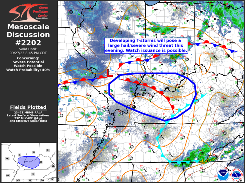
Mesoscale Discussion 2202
NWS Storm Prediction Center Norman OK
0837 AM CST Mon Nov 04 2024

Areas affected...central/eastern Oklahoma and north Texas

Concerning...Severe potential...Tornado Watch likely

Valid 041437Z - 041700Z

Probability of Watch Issuance...80 percent

SUMMARY...The severe/tornado threat is likely to increase by late
morning.

DISCUSSION...A very moist airmass is present from north Texas to
much of eastern Oklahoma with dewpoints in the upper 60s. This has
already yielded 1000 to 1500 J/kg MLCAPE with minimal surface
heating. Given the minimal inhibition (per SPC mesoanalysis and
regional 12Z RAOBs), expect widespread thunderstorm development by
late morning to early afternoon. Moderate instability and strong
shear will support supercells capable of all hazards. Parts of
central and south-central Oklahoma (near the I-35 corridor) have the
greatest uncertainty. Outflow from this mornings storms has advanced
east of I-35 with low 60s dewpoints and northerly/westerly flow.
However, strong, southerly flow is trying to stall this boundary and
lead to northward/westward airmass recovery within this corridor.

A tornado watch will eventually be needed, but it is unclear whether
the threat will start to increase in the next 1 to 2 hours or closer
to mid-day when the primary ascent overspreads the region. Trends
will be monitored and a watch will be issued when an organized
severe threat appears imminent.

..Bentley/Hart.. 11/04/2024

...Please see www.spc.noaa.gov for graphic product...

ATTN...WFO...TSA...FWD...OUN...

LAT...LON   33889847 34679833 35399776 36279652 36399579 36329531
            35929498 34839505 34099554 33789591 33519652 33349771
            33369825 33489886 33889847
https://www.spc.noaa.gov/products/md/md2202.html
date: 2024-11-03, from: NOAA tornado/severe thunderstorm watches, mesoscale discussions, convective outlooks, fire weather outlooks

Day 1 Convective Outlook
NWS Storm Prediction Center Norman OK
0741 PM CDT Sat Nov 02 2024

Valid 030100Z - 031200Z

...THERE IS A SLIGHT RISK OF SEVERE THUNDERSTORMS FROM PARTS OF
SOUTHWEST TEXAS INTO CENTRAL OKLAHOMA...

...SUMMARY...
Scattered strong to severe storms will be possible through tonight,
primarily from the Permian Basin and South Plains into Oklahoma.

...Northwest TX into OK...
Scattered clusters of rain and storms persist this evening from
extreme southeast NM across the South Plains and into central OK.
The large-scale instability gradient currently extends south of the
aggregate outflow, roughly from Midland TX to Ardmore OK, with
1000-1500 J/kg MUCAPE to the south.

Given the persistent southerly flow regime through tonight, a moist
and unstable air mass will likely spread north, with elevated
instability increasing over currently rain-cooled areas from
northwest TX into OK.

In the near term, the greatest supercell threat will remain over the
Permian Basin, in closer proximity to the most unstable air, with
hail or brief tornado risk. With time, storms may tend to
consolidate just north of the instability gradient, with an
increasing low-level jet supporting locally damaging gusts. Ambient
SRH over 200 m2/s2 may also favor embedded circulations at times,
especially if the activity can consolidate into a squall line as
indicated by some models.

..Jewell.. 11/03/2024
https://www.spc.noaa.gov/products/outlook/day1otlk_0100.html
date: 2024-11-03, from: NOAA tornado/severe thunderstorm watches, mesoscale discussions, convective outlooks, fire weather outlooks

URGENT - IMMEDIATE BROADCAST REQUESTED
Tornado Watch Number 698
NWS Storm Prediction Center Norman OK
230 PM CDT Sat Nov 2 2024

The NWS Storm Prediction Center has issued a

* Tornado Watch for portions of
  Southeast New Mexico
  West Texas

* Effective this Saturday afternoon and evening from 230 PM until
  900 PM CDT.

* Primary threats include...
  A couple tornadoes possible
  Scattered large hail and isolated very large hail events to 2.5
    inches in diameter possible
  Isolated damaging wind gusts to 70 mph possible

SUMMARY...Isolated to scattered severe thunderstorms are forecast
this afternoon into the evening across the Permian Basin.  A few
supercells capable of large to very large hail (1 to 2.5 inches in
diameter) and severe gusts (60-70 mph) are expected.  As the
low-level winds strengthen late this afternoon into the early
evening, a risk for a couple of tornadoes may develop with the more
intense supercells to the south of and immediately near an outflow
boundary draped from west to east across the area.  Storms will
likely grow upscale into one or more small clusters later this
evening with severe wind and hail becoming the primary hazards.

The tornado watch area is approximately along and 50 statute miles
north and south of a line from 10 miles southwest of Carlsbad NM to
40 miles northeast of Midland TX. For a complete depiction of the
watch see the associated watch outline update (WOUS64 KWNS WOU8).

PRECAUTIONARY/PREPAREDNESS ACTIONS...

REMEMBER...A Tornado Watch means conditions are favorable for
tornadoes and severe thunderstorms in and close to the watch
area. Persons in these areas should be on the lookout for
threatening weather conditions and listen for later statements
and possible warnings.

&&

AVIATION...Tornadoes and a few severe thunderstorms with hail
surface and aloft to 2.5 inches. Extreme turbulence and surface wind
gusts to 60 knots. A few cumulonimbi with maximum tops to 500. Mean
storm motion vector 23025.

...Smith
https://www.spc.noaa.gov/products/watch/ww0698.html
date: 2024-11-03, from: NOAA tornado/severe thunderstorm watches, mesoscale discussions, convective outlooks, fire weather outlooks

STATUS REPORT ON WW 698

SEVERE WEATHER THREAT CONTINUES RIGHT OF A LINE FROM 55 N MRF TO
55 SSE CVS.

..WEINMAN..11/03/24

ATTN...WFO...MAF...


STATUS REPORT FOR WT 698

SEVERE WEATHER THREAT CONTINUES FOR THE FOLLOWING AREAS

TXC003-115-135-165-301-317-329-389-475-495-030140-

TX
.    TEXAS COUNTIES INCLUDED ARE

ANDREWS              DAWSON              ECTOR
GAINES               LOVING              MARTIN
MIDLAND              REEVES              WARD
WINKLER


THE WATCH STATUS MESSAGE IS FOR GUIDANCE PURPOSES ONLY.  PLEASE
REFER TO WATCH COUNTY NOTIFICATION STATEMENTS FOR OFFICIAL
INFORMATION ON COUNTIES...INDEPENDENT CITIES AND MARINE ZONES
CLEARED FROM SEVERE THUNDERSTORM AND TORNADO WATCHES.