
(date: 2025-04-06 06:07:17)
date: 2025-04-06, from: Eastern Pacific Basin GIS Data
The Eastern North Pacific hurricane season runs from May 15th through November 30th.
date: 2025-04-06, from: NOAA tornado/severe thunderstorm watches, mesoscale discussions, convective outlooks, fire weather outlooks

Mesoscale Discussion 0425
NWS Storm Prediction Center Norman OK
0734 AM CDT Sun Apr 06 2025

Areas affected...parts of sern MS through cntrl AL

Concerning...Tornado Watch 131...

Valid 061234Z - 061430Z

The severe weather threat for Tornado Watch 131 continues.

SUMMARY...Convection may continue to undergo further organization
and intensification through 9-10 AM CDT, accompanied by increasing
risk for strong surface gusts, and a continuing risk for tornadoes.

DISCUSSION...At least a bit broader, lower/mid-tropospheric cyclonic
circulation appears to be evolving, perhaps including a surface
meso-low now migrating east-northeastward into/across the Demopolis
AL vicinity.  Latest Rapid Refresh now indicates a more prominent
south-southwesterly speed maximum associated with this feature,
including 50+ kt in the 850-700 mb layer.  Although moisture
characterized by mid 60s+ surface dew points across central Alabama,
between Montgomery and Birmingham still appear to supporting only
modest CAPE (around 500 J/kg sampled in 12Z BMX sounding), low-level
moisture advection and at least some boundary layer warming are
likely to contribute to further destabilization in advance of the
convection during the next few hours.  Inflow of this air mass may
be sufficient to support at least a gradual further intensification
of activity during the next few hours, accompanied by increasing
potential for strong surface gusts and a few tornadoes.

Discrete thunderstorm development is also being maintained near/just
ahead of the southern flank of the evolving convective system, and
the occasional intensification of these cells, before merging into
the line, may also be accompanied by increasing potential for a
tornado near the Selma/Montgomery vicinities through mid morning.

..Kerr.. 04/06/2025

...Please see www.spc.noaa.gov for graphic product...

ATTN...WFO...BMX...MOB...JAN...

LAT...LON   33198688 33358539 32058702 31338798 31068892 32338827
            33198688

MOST PROBABLE PEAK TORNADO INTENSITY...100-130 MPH
MOST PROBABLE PEAK WIND GUST...55-70 MPH
MOST PROBABLE PEAK HAIL SIZE...1.00-1.75 IN
https://www.spc.noaa.gov/products/md/md0425.html
date: 2025-04-06, from: NOAA tornado/severe thunderstorm watches, mesoscale discussions, convective outlooks, fire weather outlooks

Day 1 Convective Outlook
NWS Storm Prediction Center Norman OK
0739 AM CDT Sun Apr 06 2025

Valid 061300Z - 071200Z

...THERE IS A SLIGHT RISK OF SEVERE THUNDERSTORMS ACROSS PORTIONS OF
SOUTHERN MISSISSIPPI...CENTRAL AND SOUTHERN ALABAMA...WESTERN
GEORGIA...AND THE FLORIDA PANHANDLE...

...SUMMARY...
A wind-damage and isolated tornado threat is possible today across
parts of the Southeast. Marginally severe wind gusts will also be
possible in parts of the southern Appalachians into southern
Virginia.

...Synopsis...
Elongated upper troughing currently extends from the central Plains
southwestward through northern Mexico. A shortwave trough embedded
within this larger upper troughing is currently moving northeastward
through OK, while another embedded shortwave trough exists farther
west over northwest Mexico. The surface pattern features a modest
low over east-central MS, with a cold front extending southwestward
through southeast LA. An outflow boundary also intersects this low,
extending northeastward into northern GA. An extensive line of
thunderstorms exists along these boundaries in relatively continuous
line from south-central MS into northeast AL.

The parent upper trough is forecast to gradually move eastward
throughout the day, likely ending the period extended from the Ozark
Plateau into central Mexico, with the embedded shortwaves making
farther eastward/northeastward progression as well. The surface low
is also expected to move gradually northeastward, with the cold
front and associated convective line moving eastward throughout the
day.

...Southeast...
The airmass downstream of the ongoing convective line mentioned in
the synopsis is characterized by dewpoints in the mid to upper 60s.
Thermodynamic profiles are expected to remain relatively warm
throughout the day, but the low-level moisture already in place
should still support at least modest buoyancy ahead of the line as
it progresses eastward. Though the strongest upper-level winds will
be behind the front, sufficient mid-level flow parallel to the
boundary combined with the modest buoyancy should maintain
convective organization. Primary severe risk with this linear
convection will be damaging gusts. Moderate to strong low-level flow
is expected to persist along and ahead of the convective line as
well, resulting in veering low-level wind profiles and enough
low-level shear to support embedded supercells capable of wind
damage and tornadoes.

As mentioned in MCD #425, some near-term (i.e. through mid-morning)
increase in convective organization is possible, due to a
persistence of the strong low-level flow and deepening meso-low.
This increased organization would resultant in a greater potential
for strong gusts and/or tornadoes.

...Southern Appalachians/Piedmont...
Warmer air aloft is expected to have a greater influence over these
regions. With less buoyancy anticipated through the
morning/afternoon, convective intensity should remain muted. Given
the strong shear across these areas, a few strong to severe storms
may produce wind damage.

..Mosier/Kerr.. 04/06/2025
https://www.spc.noaa.gov/products/outlook/day1otlk_1300.html
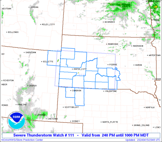
date: 2025-04-06, from: NOAA tornado/severe thunderstorm watches, mesoscale discussions, convective outlooks, fire weather outlooks

URGENT - IMMEDIATE BROADCAST REQUESTED
Tornado Watch Number 131
NWS Storm Prediction Center Norman OK
245 AM CDT Sun Apr 6 2025

The NWS Storm Prediction Center has issued a

* Tornado Watch for portions of
  Central and Southwest Alabama
  Northwest Georgia
  Far Southeast Mississippi

* Effective this Sunday morning from 245 AM until 1000 AM CDT.

* Primary threats include...
  A couple tornadoes possible
  Scattered damaging wind gusts to 70 mph possible

SUMMARY...Thunderstorms continue to gradually move southeastward
across the Southeast States. Low-level wind fields remain strong,
supporting the potential for damaging gusts and line-embedded
tornadoes. Additionally, there is also some chance for a few storms
ahead of the main line. Environmental conditions suggest that any
persistent discrete storms could become supercellular and capable of
producing damaging gusts and tornadoes.

The tornado watch area is approximately along and 45 statute miles
north and south of a line from 135 miles southwest of Birmingham AL
to 15 miles southeast of Rome GA. For a complete depiction of the
watch see the associated watch outline update (WOUS64 KWNS WOU1).

PRECAUTIONARY/PREPAREDNESS ACTIONS...

REMEMBER...A Tornado Watch means conditions are favorable for
tornadoes and severe thunderstorms in and close to the watch
area. Persons in these areas should be on the lookout for
threatening weather conditions and listen for later statements
and possible warnings.

&&

OTHER WATCH INFORMATION...CONTINUE...WW 128...WW 129...WW 130...

AVIATION...Tornadoes and a few severe thunderstorms with hail
surface and aloft to 1.5 inches. Extreme turbulence and surface wind
gusts to 60 knots. A few cumulonimbi with maximum tops to 500. Mean
storm motion vector 24035.

...Mosier
https://www.spc.noaa.gov/products/watch/ww0131.html
date: 2025-04-06, from: NOAA tornado/severe thunderstorm watches, mesoscale discussions, convective outlooks, fire weather outlooks
STATUS REPORT ON WW 131

THE SEVERE WEATHER THREAT CONTINUES ACROSS THE ENTIRE WATCH AREA.

..KERR..04/06/25

ATTN...WFO...BMX...MOB...FFC...


STATUS REPORT FOR WT 131

SEVERE WEATHER THREAT CONTINUES FOR THE FOLLOWING AREAS

ALC001-007-009-015-019-021-023-025-027-029-037-047-051-055-063-
065-073-091-099-105-111-115-117-119-121-123-125-129-131-
061240-

AL
.    ALABAMA COUNTIES INCLUDED ARE

AUTAUGA              BIBB                BLOUNT
CALHOUN              CHEROKEE            CHILTON
CHOCTAW              CLARKE              CLAY
CLEBURNE             COOSA               DALLAS
ELMORE               ETOWAH              GREENE
HALE                 JEFFERSON           MARENGO
MONROE               PERRY               RANDOLPH
ST. CLAIR            SHELBY              SUMTER
TALLADEGA            TALLAPOOSA          TUSCALOOSA
WASHINGTON           WILCOX


GAC015-045-047-055-097-115-129-143-149-213-223-233-295-313-
061240-

GA
.    GEORGIA COUNTIES INCLUDED ARE

BARTOW               CARROLL             CATOOSA
https://www.spc.noaa.gov/products/watch/ws0131.html
date: 2025-04-06, from: NOAA tornado/severe thunderstorm watches, mesoscale discussions, convective outlooks, fire weather outlooks
STATUS REPORT ON WW 129

SEVERE WEATHER THREAT CONTINUES RIGHT OF A LINE FROM 20 WSW PIB
TO 20 NE MCB TO 40 WNW MEI TO 5 E CBM TO 20 E CBM.

PARTS OF REMAINING VALID PORTION OF WW 129 MAY BE LOCALLY EXTENDED
IN TIME, A COUPLE OF HOURS BEYOND PREVIOUSLY SCHEDULED 10Z
EXPIRATION.

..KERR..04/06/25

ATTN...WFO...LIX...JAN...MEG...


STATUS REPORT FOR WT 129

SEVERE WEATHER THREAT CONTINUES FOR THE FOLLOWING AREAS

MSC023-031-035-061-065-067-069-073-075-077-087-091-099-101-103-
121-123-127-129-061000-

MS
.    MISSISSIPPI COUNTIES INCLUDED ARE

CLARKE               COVINGTON           FORREST
JASPER               JEFFERSON DAVIS     JONES
KEMPER               LAMAR               LAUDERDALE
LAWRENCE             LOWNDES             MARION
NESHOBA              NEWTON              NOXUBEE
RANKIN               SCOTT               SIMPSON
SMITH


THE WATCH STATUS MESSAGE IS FOR GUIDANCE PURPOSES ONLY.  PLEASE
REFER TO WATCH COUNTY NOTIFICATION STATEMENTS FOR OFFICIAL
INFORMATION ON COUNTIES...INDEPENDENT CITIES AND MARINE ZONES
CLEARED FROM SEVERE THUNDERSTORM AND TORNADO WATCHES.
https://www.spc.noaa.gov/products/watch/ws0129.html
date: 2025-04-06, from: NOAA tornado/severe thunderstorm watches, mesoscale discussions, convective outlooks, fire weather outlooks
STATUS REPORT ON WW 130

SEVERE WEATHER THREAT CONTINUES RIGHT OF A LINE FROM 50 S TYS TO
40 SSE TYS.

..KERR..04/06/25

ATTN...WFO...MRX...GSP...


STATUS REPORT FOR WT 130

SEVERE WEATHER THREAT CONTINUES FOR THE FOLLOWING AREAS

NCC043-113-061040-

NC
.    NORTH CAROLINA COUNTIES INCLUDED ARE

CLAY                 MACON


THE WATCH STATUS MESSAGE IS FOR GUIDANCE PURPOSES ONLY.  PLEASE
REFER TO WATCH COUNTY NOTIFICATION STATEMENTS FOR OFFICIAL
INFORMATION ON COUNTIES...INDEPENDENT CITIES AND MARINE ZONES
CLEARED FROM SEVERE THUNDERSTORM AND TORNADO WATCHES.
https://www.spc.noaa.gov/products/watch/ws0130.html
date: 2025-04-06, from: NOAA tornado/severe thunderstorm watches, mesoscale discussions, convective outlooks, fire weather outlooks

Day 4-8 Convective Outlook
NWS Storm Prediction Center Norman OK
0352 AM CDT Sun Apr 06 2025

Valid 091200Z - 141200Z

...DISCUSSION...
...Wednesday/Day 4 to Friday/Day 6...
During the mid to late week, a mid-level shortwave trough is
forecast to amplify and move southeastward from the north-central
states into the eastern U.S. Low-level moisture return ahead of the
trough is expected to be slow, which should result in only weak
instability ahead of the system. As the trough progresses
southeastward, isolated strong thunderstorms will be possible
Wednesday night in parts of the central Plains. On Thursday, an
isolated severe threat may develop in parts of the Ozarks and
Ark-La-Tex. By Friday, the system is forecast to be in the
Southeast, where isolated severe storms will be possible in parts of
Georgia and the Carolinas. Any severe threat that develops from
Wednesday to Friday is expected to be marginal, mainly due to issues
with poor moisture return and relatively weak instability.

...Saturday/Day 7 and Sunday/Day 8...
On Saturday, a mid-level ridge is forecast to move eastward across
the central U.S. Some low-level moisture is expected to return
northward into the Great Plains, where instability may become strong
enough for a severe threat. However, subsidence in the vicinity of
the ridge is expected to keep any threat that develops very
isolated.

On Sunday, model forecasts suggest that a long fetch of
west-northwest mid-level flow becomes established over much of the
U.S. Although isolated thunderstorms may form within a somewhat
moist airmass over parts of the south-central states Sunday
afternoon, large-scale ascent is forecast to remain weak. This,
combined with uncertainties at this extended range, suggest that
predictability is low.
https://www.spc.noaa.gov/products/exper/day4-8/
date: 2025-04-05, from: NOAA tornado/severe thunderstorm watches, mesoscale discussions, convective outlooks, fire weather outlooks
Mesoscale Discussion 0416
NWS Storm Prediction Center Norman OK
0314 PM CDT Sat Apr 05 2025

Areas affected...far northeast Louisiana...northern Mississippi and
northwest Alabama.

Concerning...Tornado Watch 122...

Valid 052014Z - 052215Z

The severe weather threat for Tornado Watch 122 continues.

SUMMARY...A line of storms with embedded supercells continues across
eastern portions of watch 122. A downstream tornado watch will
eventually be needed across northeast Louisiana, northern/central
Mississippi and northwest Alabama.

DISCUSSION...A line of storms with embedded supercells is slowly
drifting east near the Arkansas/Mississippi border. SPC mesoanalysis
shows 2500 J/kg MLCAPE ahead of this activity with 50 to 60 knots of
effective shear. This will support a continued threat for supercells
capable of all severe weather hazards. The JAN VWP currently shows a
relatively straight low-level hodograph where deeper mixing has
occurred. However, winds have remained more backed across northern
Mississippi where some sheltering from upper-level clouds has
occurred. Expect low-level shear to strengthen later this evening as
the low-level jet intensifies closer to 00Z. This cluster of
supercells across southeast Arkansas may eventually congeal into
another bowing segment across northern Mississippi with an increased
severe wind threat this afternoon.

In addition, scattered showers have developed across central
Mississippi within the unstable, uncapped airmass. Most of the
activity has not had any lightning, indicating it is relatively
shallow within the deep moist layer shown by the 12Z JAN RAOB.
Recently some lightning has been observed with the deeper storms
across eastern Mississippi. It is still unclear whether this
activity will congeal into one more more supercells this
afternoon/evening. If a mature supercell can develop, the
environment would support all severe weather hazards including the
potential for a strong tornado.

A tornado watch will eventually be needed for this region by late
this afternoon to early evening for the storms moving out of
northern Louisiana and eastern Arkansas. However, if the storms
across central/eastern Mississippi continue to deepen/mature, a
tornado watch may be needed sooner.

..Bentley/Guyer.. 04/05/2025

...Please see www.spc.noaa.gov for graphic product...

ATTN...WFO...BMX...HUN...MEG...JAN...LZK...

LAT...LON   32989155 34179118 34829040 35038964 34988798 34688746
            33498739 32758785 32288895 32288989 32209110 32399163
            32989155

MOST PROBABLE PEAK TORNADO INTENSITY...120-150 MPH
MOST PROBABLE PEAK WIND GUST...65-80 MPH
MOST PROBABLE PEAK HAIL SIZE...1.50-2.50 IN
https://www.spc.noaa.gov/products/md/md0416.html
date: 2025-04-05, from: NOAA tornado/severe thunderstorm watches, mesoscale discussions, convective outlooks, fire weather outlooks

Mesoscale Discussion 0414
NWS Storm Prediction Center Norman OK
0234 PM CDT Sat Apr 05 2025

Areas affected...western Tennessee to far southern Kentucky

Concerning...Tornado Watch 122...124...

Valid 051934Z - 052130Z

The severe weather threat for Tornado Watch 122, 124 continues.

SUMMARY...A damaging wind and tornado threat is expected to persist
through the afternoon.

DISCUSSION...A well-developed squall line continues across western
Tennessee. Measured wind gusts have been mostly in the 35 to 45 knot
range recently as the apex of the bow weakened somewhat as it moved
into an airmass featuring low 50s temperatures. The only exception
was a measured 51 kt gust at KHKA at 1917Z on the northern end of
the bow.  Some enhancement of this bow is possible over the next 1
to 2 hours as it interacts with a more unstable surface airmass
along the front across southern Tennessee with temperatures in the
low 80s and dewpoints in the mid 60s. In addition, some enhancement
of the low-level jet (between 1 and 2 km) has been sampled by the
KOHX VWP. This will further support maintenance of the MCS and its
associated wind threat, and will also aid in the low-level shear
favorable for some embedded tornado threat. Expect the apex of this
bow to continue to orient along the instability gradient, along and
slightly south of I-40 between Memphis and Nashville, TN.

..Bentley.. 04/05/2025

...Please see www.spc.noaa.gov for graphic product...

ATTN...WFO...LMK...OHX...HUN...PAH...MEG...

LAT...LON   35328971 35708947 36128941 36798795 37188678 36988598
            36058563 35078624 34868817 34808923 34909022 35328971

MOST PROBABLE PEAK TORNADO INTENSITY...UP TO 95 MPH
MOST PROBABLE PEAK WIND GUST...65-80 MPH
MOST PROBABLE PEAK HAIL SIZE...UP TO 1.25 IN
https://www.spc.noaa.gov/products/md/md0414.html
date: 2025-04-05, from: NOAA tornado/severe thunderstorm watches, mesoscale discussions, convective outlooks, fire weather outlooks

URGENT - IMMEDIATE BROADCAST REQUESTED
Tornado Watch Number 122
NWS Storm Prediction Center Norman OK
955 AM CDT Sat Apr 5 2025

The NWS Storm Prediction Center has issued a

* Tornado Watch for portions of
  Southern and Eastern Arkansas
  Northern Louisiana
  Northern Mississippi
  Western Tennessee
  Northeast Texas

* Effective this Saturday morning and evening from 955 AM until
  700 PM CDT.

* Primary threats include...
  A few tornadoes likely with a couple intense tornadoes possible
  Scattered damaging wind gusts to 70 mph likely
  Scattered large hail and isolated very large hail events to 2
    inches in diameter possible

SUMMARY...Severe storms including supercells are expected to
increase through late morning into the afternoon, with tornadoes,
damaging winds, and hail all possible. See Mesoscale Discussion 409
for additional meteorological details.

The tornado watch area is approximately along and 65 statute miles
north and south of a line from 20 miles south of Longview TX to 35
miles east northeast of Jackson TN. For a complete depiction of the
watch see the associated watch outline update (WOUS64 KWNS WOU2).

PRECAUTIONARY/PREPAREDNESS ACTIONS...

REMEMBER...A Tornado Watch means conditions are favorable for
tornadoes and severe thunderstorms in and close to the watch
area. Persons in these areas should be on the lookout for
threatening weather conditions and listen for later statements
and possible warnings.

&&

AVIATION...Tornadoes and a few severe thunderstorms with hail
surface and aloft to 2 inches. Extreme turbulence and surface wind
gusts to 60 knots. A few cumulonimbi with maximum tops to 550. Mean
storm motion vector 23035.

...Guyer
https://www.spc.noaa.gov/products/watch/ww0122.html
date: 2025-04-05, from: NOAA tornado/severe thunderstorm watches, mesoscale discussions, convective outlooks, fire weather outlooks
STATUS REPORT ON WW 122

SEVERE WEATHER THREAT CONTINUES RIGHT OF A LINE FROM 25 NNW LFK
TO 10 SE SHV TO 25 SE ELD TO 25 ENE LLQ TO 55 SW MEM TO 30 WSW
MKL TO 10 N MKL TO 35 NNE MKL TO 40 SSW PAH.

..BENTLEY..04/05/25

ATTN...WFO...LZK...JAN...SHV...MEG...


STATUS REPORT FOR WT 122

SEVERE WEATHER THREAT CONTINUES FOR THE FOLLOWING AREAS

ARC003-017-041-043-107-052140-

AR
.    ARKANSAS COUNTIES INCLUDED ARE

ASHLEY               CHICOT              DESHA
DREW                 PHILLIPS


LAC013-027-031-049-061-067-069-073-081-085-111-127-052140-

LA
.    LOUISIANA PARISHES INCLUDED ARE

BIENVILLE            CLAIBORNE           DE SOTO
JACKSON              LINCOLN             MOREHOUSE
NATCHITOCHES         OUACHITA            RED RIVER
SABINE               UNION               WINN


MSC003-009-011-027-033-071-083-093-107-117-119-133-135-137-139-
141-143-145-151-161-052140-

MS
https://www.spc.noaa.gov/products/watch/ws0122.html
date: 2025-04-05, from: NOAA tornado/severe thunderstorm watches, mesoscale discussions, convective outlooks, fire weather outlooks
URGENT - IMMEDIATE BROADCAST REQUESTED
Tornado Watch Number 123
NWS Storm Prediction Center Norman OK
1235 PM CDT Sat Apr 5 2025

The NWS Storm Prediction Center has issued a

* Tornado Watch for portions of
  Southwest Louisiana
  Southeast Texas
  Coastal Waters

* Effective this Saturday afternoon and evening from 1235 PM
  until 900 PM CDT.

* Primary threats include...
  A few tornadoes possible
  Scattered damaging wind gusts to 70 mph possible
  Scattered large hail events to 1.5 inches in diameter possible

SUMMARY...Severe storms are expected to develop this afternoon
initially across southeast Texas, before progressing into southwest
Louisiana late this afternoon and evening. A moist/unstable
environment will support the potential for all severe hazards,
including tornadoes.

The tornado watch area is approximately along and 70 statute miles
east and west of a line from 75 miles north of Port Arthur TX to 25
miles south of Houston TX. For a complete depiction of the watch see
the associated watch outline update (WOUS64 KWNS WOU3).

PRECAUTIONARY/PREPAREDNESS ACTIONS...

REMEMBER...A Tornado Watch means conditions are favorable for
tornadoes and severe thunderstorms in and close to the watch
area. Persons in these areas should be on the lookout for
threatening weather conditions and listen for later statements
and possible warnings.

&&

OTHER WATCH INFORMATION...CONTINUE...WW 122...

AVIATION...Tornadoes and a few severe thunderstorms with hail
surface and aloft to 1.5 inches. Extreme turbulence and surface wind
gusts to 60 knots. A few cumulonimbi with maximum tops to 550. Mean
storm motion vector 24025.

...Guyer
https://www.spc.noaa.gov/products/watch/ww0123.html
date: 2025-04-05, from: NOAA tornado/severe thunderstorm watches, mesoscale discussions, convective outlooks, fire weather outlooks
STATUS REPORT ON WW 123

SEVERE WEATHER THREAT CONTINUES RIGHT OF A LINE FROM 30 WSW LFK
TO 30 N PSX.

FOR ADDITIONAL INFORMATION SEE MESOSCALE DISCUSSION 0415

..LYONS..04/05/25

ATTN...WFO...LCH...HGX...


STATUS REPORT FOR WT 123

SEVERE WEATHER THREAT CONTINUES FOR THE FOLLOWING AREAS

LAC011-115-052140-

LA
.    LOUISIANA PARISHES INCLUDED ARE

BEAUREGARD           VERNON


TXC039-071-157-167-199-201-241-245-291-339-351-361-373-407-457-
052140-

TX
.    TEXAS COUNTIES INCLUDED ARE

BRAZORIA             CHAMBERS            FORT BEND
GALVESTON            HARDIN              HARRIS
JASPER               JEFFERSON           LIBERTY
MONTGOMERY           NEWTON              ORANGE
POLK                 SAN JACINTO         TYLER


GMZ335-430-052140-
https://www.spc.noaa.gov/products/watch/ws0123.html
date: 2025-04-05, from: NOAA tornado/severe thunderstorm watches, mesoscale discussions, convective outlooks, fire weather outlooks
Day 1 Convective Outlook
NWS Storm Prediction Center Norman OK
0259 PM CDT Sat Apr 05 2025

Valid 052000Z - 061200Z

...THERE IS A MODERATE RISK OF SEVERE THUNDERSTORMS FOR NORTHERN
MISSISSIPPI INTO WESTERN TENNESSEE...

...SUMMARY...
Severe storms, capable of producing damaging wind gusts, large hail
and several tornadoes are still expected from the Sabine River
Valley northeastward into the Mid-South and lower Mississippi and
Ohio Valleys. Strong tornadoes, very large hail, and severe wind
gusts are all possible.

...20Z Update...
The primary changes made to the 20Z Convective Outlook Update were
to trim severe probabilities from the west to account for the
passage of the ongoing QLCS over the Mid-South into the Lower MS
Valley region. Severe hail may still accompany the stronger storms
along southern extent of or immediately ahead of the QLCS.
Otherwise, strong to severe surface gusts and tornadoes (a couple of
which may be strong) may occur with embedded mesovortices and LEWPs
within the QLCS, as well as with any storms ahead of the line. See
the previous outlook (below) for more details.

..Squitieri.. 04/05/2025

.PREV DISCUSSION... /ISSUED 1140 AM CDT Sat Apr 05 2025/

...East TX/ArkLaTex to Lower Mississippi Valley...
Severe storms continue to increase through late morning into midday
especially across parts of Arkansas, with the upscale-growing
MCS/bow echo near/northeast of the Little Rock area as of 1130 CDT.
A 60 kt wind gust was recently measured at KLRF/North Little Rock.
This bowing MCS should continue to favor the zone near/immediately
north of the effective boundary that precedes it (roughly parallel
to I-40), likely taking it into western Tennessee this afternoon,
potentially near the Memphis metro vicinity. See Mesoscale
Discussion 411 for additional details. A Moderate Risk upgrade has
been introduced for this scenario, as well as potential
semi-discrete warm-sector development later this afternoon to its
south.

Within the axis of a strong low-level jet (south-southwesterly 50-60
kt across the ArkLaTex and ArkLaMiss), supercell longevity/tornado
potential will be maximized with any diurnal warm-sector development
that occurs away from (east-southeast of) the outflow-reinforced
effective front, although the extent of that my tend to be somewhat
curbed by persistent cloud cover and semi-mild mid-level
temperatures (-9 or -10C at 500mb) into the warm sector.
Additionally, deep-layer shear vectors will be largely parallel to
the effective front regionally, suggestive of a mixed convective
mode including HP supercells/smaller-scale bows in close proximity
to the convectively modified effective front. The front will become
more east/southeastward-progressive later this afternoon and tonight
across east/southeast Texas, southern Arkansas, and Louisiana.
Overall, some tornadoes are expected regionally, a few of which
could be strong, aside from damaging winds and isolated large hail.

...Mid-South into the TN/OH Valleys...
Farther north, the boundary will be less progressive throughout the
morning/early afternoon, particularly north of a weak low currently
over northeast Texas. The boundary will likely sharpen during this
time, before then becoming more progressive once again as the
convectively augmented shortwave trough currently moving into
western Oklahoma progresses into the region. This will likely result
in a bowing line segment with damaging gusts as the primary severe
risk. However, given the strength of the low-level flow, some
embedded tornado potential exists as well.
https://www.spc.noaa.gov/products/outlook/day1otlk_2000.html
date: 2025-04-05, from: NOAA tornado/severe thunderstorm watches, mesoscale discussions, convective outlooks, fire weather outlooks

Day 3 Convective Outlook
NWS Storm Prediction Center Norman OK
0155 PM CDT Sat Apr 05 2025

Valid 071200Z - 081200Z

...THERE IS A MARGINAL RISK OF SEVERE THUNDERSTORMS FROM NORTHERN
FLORIDA AND SOUTHERN GEORGIA INTO THE EASTERN CAROLINAS...

...SUMMARY...
A marginal wind-damage threat is possible on Monday across parts of
the southern Atlantic Seaboard into northern Florida.

...Synopsis and Discussion...
A positive-tilt upper trough will sweep across the Southeast and Mid
Atlantic on Monday with a cold front rapidly moving to the East
Coast by 00Z. Widespread rain and thunderstorms will be ongoing
throughout the period along the front, and a few strong gusts cannot
be ruled out. Forecast soundings depict poor mid/upper lapse rates
and weak instability ahead of the front. However, the combination of
steepening low-level lapse rates/favorable time of day and moderate
deep-layer mean winds may support sporadic strong wind gusts.

..Jewell.. 04/05/2025
https://www.spc.noaa.gov/products/outlook/day3otlk_1930.html
date: 2025-04-05, from: NOAA tornado/severe thunderstorm watches, mesoscale discussions, convective outlooks, fire weather outlooks
STATUS FOR WATCH 0124 HAS NOT BEEN ISSUED YET
https://www.spc.noaa.gov/products/watch/ws0124.html
date: 2025-04-05, from: NOAA tornado/severe thunderstorm watches, mesoscale discussions, convective outlooks, fire weather outlooks
URGENT - IMMEDIATE BROADCAST REQUESTED
Tornado Watch Number 124
NWS Storm Prediction Center Norman OK
145 PM CDT Sat Apr 5 2025

The NWS Storm Prediction Center has issued a

* Tornado Watch for portions of
  Northwest Alabama
  Southern Kentucky
  Western and Middle Tennessee

* Effective this Saturday afternoon and evening from 145 PM until
  900 PM CDT.

* Primary threats include...
  A few tornadoes and a couple intense tornadoes possible
  Widespread damaging winds likely with isolated significant gusts
    to 75 mph possible
  Isolated large hail events to 1.5 inches in diameter possible

SUMMARY...A well-organized bow echo will continue east-northeastward
this afternoon, while other semi-discrete supercells may develop
ahead of it, and southward into the warm sector.

The tornado watch area is approximately along and 80 statute miles
north and south of a line from 65 miles north northwest of Muscle
Shoals AL to 55 miles east of Nashville TN. For a complete depiction
of the watch see the associated watch outline update (WOUS64 KWNS
WOU4).

PRECAUTIONARY/PREPAREDNESS ACTIONS...

REMEMBER...A Tornado Watch means conditions are favorable for
tornadoes and severe thunderstorms in and close to the watch
area. Persons in these areas should be on the lookout for
threatening weather conditions and listen for later statements
and possible warnings.

&&

OTHER WATCH INFORMATION...CONTINUE...WW 122...WW 123...

AVIATION...Tornadoes and a few severe thunderstorms with hail
surface and aloft to 1.5 inches. Extreme turbulence and surface wind
gusts to 65 knots. A few cumulonimbi with maximum tops to 500. Mean
storm motion vector 23040.

...Guyer
https://www.spc.noaa.gov/products/watch/ww0124.html
date: 2025-04-05, from: NOAA tornado/severe thunderstorm watches, mesoscale discussions, convective outlooks, fire weather outlooks

Day 2 Fire Weather Outlook
NWS Storm Prediction Center Norman OK
0100 PM CDT Sat Apr 05 2025

Valid 061200Z - 071200Z

The Elevated area was expanded slightly based on the latest
high-resolution forecast guidance as minimum RH is forecast to be
30-40% with winds of 10-15 mph and temperatures in the mid 80s to
low 90s. Temperatures will be 5-20F above normal from Florida into
the Carolinas ahead of the approaching cold front. Winds will be
stronger (sustained around 15 mph gusting 20-25 mph) farther north
in portions of southern Georgia and the eastern Carolinas where
locally elevated conditions remain possible in the pre-frontal
environment, but RH is likely to be higher (35-50%) with fuels not
quite as dry.

..Nauslar.. 04/05/2025

.PREV DISCUSSION... /ISSUED 0150 AM CDT Sat Apr 05 2025/

...Synopsis...
A deep mid-level shortwave trough over the southern Plains will move
eastward throughout the day on Sunday, inducing a surface low across
portions of the southeast US. This will advect a relatively dry air
mass inland on the Florida peninsula, where mixing may decrease the
RH to near-critical values across parts of the region while bringing
down some higher momentum from aloft. The fuels in the region should
continue to dry through the period and are expected to be near the
90th percentile ERCs. For these reasons, have introduced an Elevated
highlight across portions of the Florida peninsula for Sunday. This
area may need to be expanded northward into north Florida and
southeast Georgia in subsequent outlooks. However, uncertainty on
exactly how low the RH will be in these regions as well as
uncertainties on fuel dryness preclude highlighting these regions at
this time.

...Please see www.spc.noaa.gov/fire for graphic product...
https://www.spc.noaa.gov/products/fire_wx/fwdy2.html
date: 2025-04-05, from: NOAA tornado/severe thunderstorm watches, mesoscale discussions, convective outlooks, fire weather outlooks

Day 2 Convective Outlook
NWS Storm Prediction Center Norman OK
1203 PM CDT Sat Apr 05 2025

Valid 061200Z - 071200Z

...THERE IS A SLIGHT RISK OF SEVERE THUNDERSTORMS CENTERED OVER
ALABAMA AND INTO PARTS OF ADJACENT STATES...

...SUMMARY...
A wind-damage and isolated tornado threat is possible on Sunday
across parts of the Southeast. Marginally severe wind gusts will
also be possible in parts of the southern Appalachians.

...Synopsis...
On Sunday, a positive-tilt trough will move slowly east out of the
southern Plains and across the lower to mid MS Valley, with
gradually increasing southwesterlies aloft across the Gulf Coast
states. A weak surface low will move out of MS and across northern
AL during the day, then northeastward across the western Carolinas
overnight. A rain-reinforced front will extend south from the low,
from northern AL into eastern MS and LA, with another boundary
extending from TN into VA. A very moist air mass will exist across
the warm sector, with moderate shear supporting scattered severe
storms.

...Eastern MS and LA...AL...
A line of thunderstorms will be ongoing along the cold front early
on Sunday where MUCAPE will be on the order of 1000-1500 J/kg.
Severe potential will be mitigated somewhat due to the relatively
warm profiles aloft, however, veering winds with height and around
50 kt at 850 mb may support embedded supercells within the line,
with both wind and brief tornado potential. Depending on the degree
of outflow/convective contamination early in the day, a slightly
better corridor of tornado threat could materialize.

..Jewell.. 04/05/2025
https://www.spc.noaa.gov/products/outlook/day2otlk_1730.html
date: 2025-04-05, from: NOAA tornado/severe thunderstorm watches, mesoscale discussions, convective outlooks, fire weather outlooks
PUBLIC SEVERE WEATHER OUTLOOK CORR 1
NWS STORM PREDICTION CENTER NORMAN OK
1148 AM CDT SAT APR 05 2025

CORRECTED FOR AREA

...Severe thunderstorms expected over parts of the Mid-South and
Lower Mississippi Valley this afternoon and evening...

* LOCATIONS...
  Western Tennessee
  Eastern Arkansas
  Northern Mississippi
  Northwest Alabama
  Louisiana
  East Texas

* HAZARDS...
  Widespread damaging winds, some hurricane force
  Several tornadoes, a few intense
  Scattered large hail, some baseball size

* SUMMARY...
  Severe storms, capable of producing damaging wind gusts, large
  hail and several tornadoes are expected from the Sabine River
  Valley northeastward into the Mid-South and lower Mississippi
  and Ohio Valleys. Strong tornadoes, very large hail, and severe
  wind gusts are all possible.

Preparedness actions...

Review your severe weather safety procedures for the possibility
of dangerous weather today. Stay tuned to NOAA Weather Radio,
weather.gov, or other media for watches and warnings. A watch
means that conditions are favorable for severe thunderstorms
over the next several hours. If a severe thunderstorm warning is
issued for your area, move to a place of safety, ideally in an
https://www.spc.noaa.gov/products/outlook/pwo.html
date: 2025-04-05, from: NOAA tornado/severe thunderstorm watches, mesoscale discussions, convective outlooks, fire weather outlooks
Day 1 Convective Outlook
NWS Storm Prediction Center Norman OK
1140 AM CDT Sat Apr 05 2025

Valid 051630Z - 061200Z

...THERE IS A MODERATE RISK OF SEVERE THUNDERSTORMS ACROSS PARTS OF
EASTERN ARKANSAS...WESTERN TENNESSEE...AND NORTHERN MISSISSIPPI...

...SUMMARY...
Severe storms, capable of producing damaging wind gusts, large hail
and several tornadoes are expected from the Sabine River Valley
northeastward into the Mid-South and lower Mississippi and Ohio
Valleys. Strong tornadoes, very large hail, and severe wind gusts
are all possible.

...East TX/ArkLaTex to Lower Mississippi Valley...
Severe storms continue to increase through late morning into midday
especially across parts of Arkansas, with the upscale-growing
MCS/bow echo near/northeast of the Little Rock area as of 1130 CDT.
A 60 kt wind gust was recently measured at KLRF/North Little Rock.
This bowing MCS should continue to favor the zone near/immediately
north of the effective boundary that precedes it (roughly parallel
to I-40), likely taking it into western Tennessee this afternoon,
potentially near the Memphis metro vicinity. See Mesoscale
Discussion 411 for additional details. A Moderate Risk upgrade has
been introduced for this scenario, as well as potential
semi-discrete warm-sector development later this afternoon to its
south.

Within the axis of a strong low-level jet (south-southwesterly 50-60
kt across the ArkLaTex and ArkLaMiss), supercell longevity/tornado
potential will be maximized with any diurnal warm-sector development
that occurs away from (east-southeast of) the outflow-reinforced
effective front, although the extent of that my tend to be somewhat
curbed by persistent cloud cover and semi-mild mid-level
temperatures (-9 or -10C at 500mb) into the warm sector.
Additionally, deep-layer shear vectors will be largely parallel to
the effective front regionally, suggestive of a mixed convective
mode including HP supercells/smaller-scale bows in close proximity
to the convectively modified effective front. The front will become
more east/southeastward-progressive later this afternoon and tonight
across east/southeast Texas, southern Arkansas, and Louisiana.
Overall, some tornadoes are expected regionally, a few of which
could be strong, aside from damaging winds and isolated large hail.

...Mid-South into the TN/OH Valleys...
Farther north, the boundary will be less progressive throughout the
morning/early afternoon, particularly north of a weak low currently
over northeast Texas. The boundary will likely sharpen during this
time, before then becoming more progressive once again as the
convectively augmented shortwave trough currently moving into
western Oklahoma progresses into the region. This will likely result
in a bowing line segment with damaging gusts as the primary severe
risk. However, given the strength of the low-level flow, some
embedded tornado potential exists as well.

..Guyer/Lyons.. 04/05/2025
https://www.spc.noaa.gov/products/outlook/day1otlk_1630.html
date: 2025-04-05, from: NOAA tornado/severe thunderstorm watches, mesoscale discussions, convective outlooks, fire weather outlooks
No watches are valid as of Sat Apr 5 12:34:01 UTC 2025.
https://www.spc.noaa.gov/products/watch/
date: 2025-04-05, from: NOAA tornado/severe thunderstorm watches, mesoscale discussions, convective outlooks, fire weather outlooks
No Mesoscale Discussions are in effect as of Sat Apr 5 12:34:01 UTC 2025.
https://www.spc.noaa.gov/products/md/
date: 2025-04-04, from: NOAA tornado/severe thunderstorm watches, mesoscale discussions, convective outlooks, fire weather outlooks
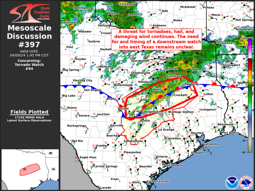
Mesoscale Discussion 0397
NWS Storm Prediction Center Norman OK
0333 PM CDT Fri Apr 04 2025

Areas affected...Northeast TX...southeast OK...western AR

Concerning...Tornado Watch 113...114...

Valid 042033Z - 042200Z

The severe weather threat for Tornado Watch 113, 114 continues.

SUMMARY...Maturing supercells will pose an increasing tornado threat
this afternoon.

DISCUSSION...Multiple supercells have developed over the last hour
across northeast TX, in the immediate vicinity of a slow-moving cold
front that extends from southeast OK into central TX. The 18Z SHV
sounding is representative of the environment across the region,
with very rich low-level moisture, large to extreme MLCAPE,
deep-layer shear sufficient for supercells, and a rather strong
low-level jet.

A corridor of increasing short-term tornado threat is evident from
northeast TX into far southeast OK and western AR, where locally
backed surface winds are resulting in 0-1 km SRH of 150-250 m2/s2.
This combination of favorable buoyancy, boundary-layer moisture, and
relatively strong low-level shear/SRH will support an increasing
tornado threat with any sustained supercells, including significant
(EF2+) tornado potential. Large hail and damaging winds could also
accompany the strongest cells.

..Dean.. 04/04/2025

...Please see www.spc.noaa.gov for graphic product...

ATTN...WFO...LZK...SHV...TSA...FWD...

LAT...LON   31889648 32739620 33549548 34629455 35499358 35179295
            34369299 32779455 31879567 31889648

MOST PROBABLE PEAK TORNADO INTENSITY...120-150 MPH
MOST PROBABLE PEAK WIND GUST...55-70 MPH
MOST PROBABLE PEAK HAIL SIZE...2.00-3.50 IN
https://www.spc.noaa.gov/products/md/md0397.html
date: 2025-04-04, from: NOAA tornado/severe thunderstorm watches, mesoscale discussions, convective outlooks, fire weather outlooks

Mesoscale Discussion 0396
NWS Storm Prediction Center Norman OK
0329 PM CDT Fri Apr 04 2025

Areas affected...southern Kentucky and northern Tennessee

Concerning...Severe potential...Watch possible

Valid 042029Z - 042300Z

Probability of Watch Issuance...60 percent

SUMMARY...Thunderstorms are expected to increase in coverage and
intensity through the afternoon across the area.  Convective trends
will be monitored for the possibility of a watch.

DISCUSSION...Warm sector convection has slowly deepened with time
with some intensification of cells as they cross over the stationary
front in southeastern Kentucky.  Updraft intensity so far has been
muted by a warm layer around 700 mb, but additional destabilization
and subtle height falls into the evening should result in more
robust updraft development over the next few hours.  Modest
low-level shear (per local VWPs) should support some tornado
potential, especially along the surface boundary, but damaging winds
and hail should be the primary threats with the strongest storms.
With storm motion predominantly to the northeast, storms will
eventually cross to the cool side of the boundary, resulting in hail
being the primary threat and eventual weakening of storms.  The
coverage and intensity of storms will be monitored regarding the
need for a watch.

..Jirak/Thompson.. 04/04/2025

...Please see www.spc.noaa.gov for graphic product...

ATTN...WFO...MRX...JKL...LMK...OHX...PAH...

LAT...LON   37248698 37718627 37888512 37818426 37738321 37458279
            36968283 36528334 36298384 36118467 36038531 36018635
            36118697 36148701 36438723 37248698

MOST PROBABLE PEAK TORNADO INTENSITY...85-115 MPH
MOST PROBABLE PEAK WIND GUST...55-70 MPH
MOST PROBABLE PEAK HAIL SIZE...1.00-1.75 IN
https://www.spc.noaa.gov/products/md/md0396.html
date: 2025-04-04, from: NOAA tornado/severe thunderstorm watches, mesoscale discussions, convective outlooks, fire weather outlooks
STATUS FOR WATCH 0117 HAS NOT BEEN ISSUED YET
https://www.spc.noaa.gov/products/watch/ws0117.html
date: 2025-04-04, from: NOAA tornado/severe thunderstorm watches, mesoscale discussions, convective outlooks, fire weather outlooks
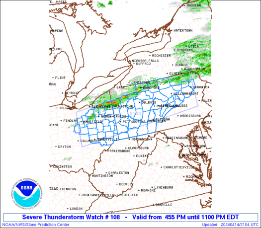
URGENT - IMMEDIATE BROADCAST REQUESTED
Severe Thunderstorm Watch Number 117
NWS Storm Prediction Center Norman OK
500 PM EDT Fri Apr 4 2025

The NWS Storm Prediction Center has issued a

* Severe Thunderstorm Watch for portions of
  South central and southeast Kentucky

* Effective this Friday afternoon and evening from 500 PM until
  1000 PM EDT.

* Primary threats include...
  Scattered large hail and isolated very large hail events to 2
    inches in diameter possible
  Scattered damaging wind gusts to 70 mph possible

SUMMARY...Isolated warm sector supercells will persist through the
afternoon/evening with the potential to produce large hail of 1-2
inches in diameter and isolated damaging gusts of 60-70 mph.

The severe thunderstorm watch area is approximately along and 40
statute miles north and south of a line from 35 miles west northwest
of Bowling Green KY to 25 miles south southeast of Jackson KY. For a
complete depiction of the watch see the associated watch outline
update (WOUS64 KWNS WOU7).

PRECAUTIONARY/PREPAREDNESS ACTIONS...

REMEMBER...A Severe Thunderstorm Watch means conditions are
favorable for severe thunderstorms in and close to the watch area.
Persons in these areas should be on the lookout for threatening
weather conditions and listen for later statements and possible
warnings. Severe thunderstorms can and occasionally do produce
tornadoes.

&&

OTHER WATCH INFORMATION...CONTINUE...WW 113...WW 114...WW
115...WW 116...

AVIATION...A few severe thunderstorms with hail surface and aloft to
2 inches. Extreme turbulence and surface wind gusts to 60 knots. A
few cumulonimbi with maximum tops to 500. Mean storm motion vector
25025.

...Thompson
https://www.spc.noaa.gov/products/watch/ww0117.html
date: 2025-04-04, from: NOAA tornado/severe thunderstorm watches, mesoscale discussions, convective outlooks, fire weather outlooks

URGENT - IMMEDIATE BROADCAST REQUESTED
Tornado Watch Number 113
NWS Storm Prediction Center Norman OK
1255 PM CDT Fri Apr 4 2025

The NWS Storm Prediction Center has issued a

* Tornado Watch for portions of
  Southwest, central and northern Arkansas
  Extreme northwest Louisiana
  Extreme southeast Oklahoma
  Northeast Texas

* Effective this Friday afternoon and evening from 1255 PM until
  900 PM CDT.

* Primary threats include...
  Several tornadoes and a couple intense tornadoes likely
  Widespread large hail and scattered very large hail events to
    2.5 inches in diameter likely
  Scattered damaging winds likely with isolated significant gusts
    to 75 mph possible

SUMMARY...Supercell development is expected along a surface front
and into the warm sector this afternoon from northeast Texas
northeastward into Arkansas.  The storm environment will support the
potential for a few strong (EF2-EF3) tornadoes, very large hail to
2.5 inches in diameter, and damaging gusts up to 75 mph as storms
congeal into multiple clusters later this afternoon.

The tornado watch area is approximately along and 75 statute miles
east and west of a line from 50 miles east northeast of Flippin AR
to 60 miles south southwest of Texarkana AR. For a complete
depiction of the watch see the associated watch outline update
(WOUS64 KWNS WOU3).

PRECAUTIONARY/PREPAREDNESS ACTIONS...

REMEMBER...A Tornado Watch means conditions are favorable for
tornadoes and severe thunderstorms in and close to the watch
area. Persons in these areas should be on the lookout for
threatening weather conditions and listen for later statements
and possible warnings.

&&

AVIATION...Tornadoes and a few severe thunderstorms with hail
surface and aloft to 2.5 inches. Extreme turbulence and surface wind
gusts to 65 knots. A few cumulonimbi with maximum tops to 550. Mean
storm motion vector 23035.

...Thompson
https://www.spc.noaa.gov/products/watch/ww0113.html
date: 2025-04-04, from: NOAA tornado/severe thunderstorm watches, mesoscale discussions, convective outlooks, fire weather outlooks
STATUS REPORT ON WW 113

THE SEVERE WEATHER THREAT CONTINUES ACROSS THE ENTIRE WATCH AREA.

..LYONS..04/04/25

ATTN...WFO...LZK...SHV...


STATUS REPORT FOR WT 113

SEVERE WEATHER THREAT CONTINUES FOR THE FOLLOWING AREAS

ARC005-009-013-019-023-025-027-029-039-045-049-051-053-057-059-
061-063-065-067-069-071-073-075-081-083-085-089-091-097-099-101-
103-105-109-113-115-117-119-121-125-127-129-133-135-137-141-145-
147-149-042140-

AR
.    ARKANSAS COUNTIES INCLUDED ARE

BAXTER               BOONE               CALHOUN
CLARK                CLEBURNE            CLEVELAND
COLUMBIA             CONWAY              DALLAS
FAULKNER             FULTON              GARLAND
GRANT                HEMPSTEAD           HOT SPRING
HOWARD               INDEPENDENCE        IZARD
JACKSON              JEFFERSON           JOHNSON
LAFAYETTE            LAWRENCE            LITTLE RIVER
LOGAN                LONOKE              MARION
MILLER               MONTGOMERY          NEVADA
NEWTON               OUACHITA            PERRY
PIKE                 POLK                POPE
PRAIRIE              PULASKI             RANDOLPH
SALINE               SCOTT               SEARCY
SEVIER               SHARP               STONE
VAN BUREN            WHITE               WOODRUFF
YELL
https://www.spc.noaa.gov/products/watch/ws0113.html
date: 2025-04-04, from: NOAA tornado/severe thunderstorm watches, mesoscale discussions, convective outlooks, fire weather outlooks
STATUS REPORT ON WW 114

THE SEVERE WEATHER THREAT CONTINUES ACROSS THE ENTIRE WATCH AREA.

..LYONS..04/04/25

ATTN...WFO...FWD...HGX...


STATUS REPORT FOR WT 114

SEVERE WEATHER THREAT CONTINUES FOR THE FOLLOWING AREAS

TXC001-041-051-145-161-185-213-225-289-293-313-331-349-395-455-
467-471-042140-

TX
.    TEXAS COUNTIES INCLUDED ARE

ANDERSON             BRAZOS              BURLESON
FALLS                FREESTONE           GRIMES
HENDERSON            HOUSTON             LEON
LIMESTONE            MADISON             MILAM
NAVARRO              ROBERTSON           TRINITY
VAN ZANDT            WALKER


THE WATCH STATUS MESSAGE IS FOR GUIDANCE PURPOSES ONLY.  PLEASE
REFER TO WATCH COUNTY NOTIFICATION STATEMENTS FOR OFFICIAL
INFORMATION ON COUNTIES...INDEPENDENT CITIES AND MARINE ZONES
CLEARED FROM SEVERE THUNDERSTORM AND TORNADO WATCHES.
https://www.spc.noaa.gov/products/watch/ws0114.html
date: 2025-04-04, from: NOAA tornado/severe thunderstorm watches, mesoscale discussions, convective outlooks, fire weather outlooks

URGENT - IMMEDIATE BROADCAST REQUESTED
Tornado Watch Number 115
NWS Storm Prediction Center Norman OK
255 PM CDT Fri Apr 4 2025

The NWS Storm Prediction Center has issued a

* Tornado Watch for portions of
  Northeast Arkansas
  Extreme southern Illinois
  Western Kentucky
  Southeast Missouri
  Norhern Mississippi
  Western and Middle Tennessee

* Effective this Friday afternoon and evening from 255 PM until
  1000 PM CDT.

* Primary threats include...
  A few tornadoes likely with a couple intense tornadoes possible
  Scattered damaging winds likely with isolated significant gusts
    to 75 mph possible
  Scattered large hail likely with isolated very large hail events
    to 2 inches in diameter possible

SUMMARY...Widely scattered supercell development is expected this
afternoon from northern Mississippi across western/Middle Tennessee
into western Kentucky.  The storm environment supports the potential
for several tornadoes (including an isolated strong tornado), large
hail up to 2 inches in diameter, and isolated damaging gusts.  The
potential for damaging winds up to 75 mph will increase later this
evening into early tonight as storm clusters spread into southeast
Missouri from Arkansas.

The tornado watch area is approximately along and 80 statute miles
east and west of a line from 30 miles east northeast of Paducah KY
to 25 miles south southwest of Memphis TN. For a complete depiction
of the watch see the associated watch outline update (WOUS64 KWNS
WOU5).

PRECAUTIONARY/PREPAREDNESS ACTIONS...

REMEMBER...A Tornado Watch means conditions are favorable for
tornadoes and severe thunderstorms in and close to the watch
area. Persons in these areas should be on the lookout for
threatening weather conditions and listen for later statements
and possible warnings.

&&

OTHER WATCH INFORMATION...CONTINUE...WW 113...WW 114...

AVIATION...Tornadoes and a few severe thunderstorms with hail
surface and aloft to 2 inches. Extreme turbulence and surface wind
gusts to 65 knots. A few cumulonimbi with maximum tops to 550. Mean
storm motion vector 24025.

...Thompson
https://www.spc.noaa.gov/products/watch/ww0115.html
date: 2025-04-04, from: NOAA tornado/severe thunderstorm watches, mesoscale discussions, convective outlooks, fire weather outlooks
URGENT - IMMEDIATE BROADCAST REQUESTED
Tornado Watch Number 114
NWS Storm Prediction Center Norman OK
225 PM CDT Fri Apr 4 2025

The NWS Storm Prediction Center has issued a

* Tornado Watch for portions of
  East central and southeast Texas

* Effective this Friday afternoon and evening from 225 PM until
  900 PM CDT.

* Primary threats include...
  A few tornadoes possible
  Scattered large hail and isolated very large hail events to 2.5
    inches in diameter likely
  Scattered damaging wind gusts to 70 mph possible

SUMMARY...Thunderstorms will intensify along and east of a
slow-moving front across east and southeast Texas through the
afternoon/evening.  The storm environment will favor supercells
capable of producing isolated very large hail (up to 2.5 inches in
diameter), damaging gusts of 60-70 mph, and a few tornadoes.

The tornado watch area is approximately along and 60 statute miles
east and west of a line from 20 miles north northeast of Longview TX
to 35 miles west southwest of College Station TX. For a complete
depiction of the watch see the associated watch outline update
(WOUS64 KWNS WOU4).

PRECAUTIONARY/PREPAREDNESS ACTIONS...

REMEMBER...A Tornado Watch means conditions are favorable for
tornadoes and severe thunderstorms in and close to the watch
area. Persons in these areas should be on the lookout for
threatening weather conditions and listen for later statements
and possible warnings.

&&

OTHER WATCH INFORMATION...CONTINUE...WW 113...

AVIATION...Tornadoes and a few severe thunderstorms with hail
surface and aloft to 2.5 inches. Extreme turbulence and surface wind
gusts to 60 knots. A few cumulonimbi with maximum tops to 600. Mean
storm motion vector 22030.

...Thompson
https://www.spc.noaa.gov/products/watch/ww0114.html
date: 2025-04-04, from: NOAA tornado/severe thunderstorm watches, mesoscale discussions, convective outlooks, fire weather outlooks
STATUS REPORT ON WW 115

THE SEVERE WEATHER THREAT CONTINUES ACROSS THE ENTIRE WATCH AREA.

..LYONS..04/04/25

ATTN...WFO...MEG...PAH...OHX...


STATUS REPORT FOR WT 115

SEVERE WEATHER THREAT CONTINUES FOR THE FOLLOWING AREAS

ARC021-031-035-037-055-077-093-107-111-123-042140-

AR
.    ARKANSAS COUNTIES INCLUDED ARE

CLAY                 CRAIGHEAD           CRITTENDEN
CROSS                GREENE              LEE
MISSISSIPPI          PHILLIPS            POINSETT
ST. FRANCIS


ILC003-069-087-127-151-153-181-042140-

IL
.    ILLINOIS COUNTIES INCLUDED ARE

ALEXANDER            HARDIN              JOHNSON
MASSAC               POPE                PULASKI
UNION


KYC007-033-035-039-047-055-075-083-105-107-139-143-145-157-177-
219-221-042140-

KY
.    KENTUCKY COUNTIES INCLUDED ARE
https://www.spc.noaa.gov/products/watch/ws0115.html
date: 2025-04-04, from: NOAA tornado/severe thunderstorm watches, mesoscale discussions, convective outlooks, fire weather outlooks
URGENT - IMMEDIATE BROADCAST REQUESTED
Tornado Watch Number 116
NWS Storm Prediction Center Norman OK
345 PM CDT Fri Apr 4 2025

The NWS Storm Prediction Center has issued a

* Tornado Watch for portions of
  Exteme west central Arkansas
  Extreme east central Oklahoma

* Effective this Friday afternoon and evening from 345 PM until
  900 PM CDT.

* Primary threats include...
  A few tornadoes and a couple intense tornadoes possible
  Scattered large hail and isolated very large hail events to 2
    inches in diameter possible
  Scattered damaging wind gusts to 70 mph possible

SUMMARY...Supercells along a stalled front will move into the area
of east central Oklahoma and west central Arkansas (close to Fort
Smith) just to the west of the earlier tornado watch to the east in
Arkansas.  A couple of tornadoes, including the chance for a strong
tornado, large hail and wind damage will all be possible this
afternoon/evening before the storms shift farther east into
Arkansas.

The tornado watch area is approximately along and 20 statute miles
east and west of a line from 40 miles northeast of Fort Smith AR to
40 miles south southwest of Poteau OK. For a complete depiction of
the watch see the associated watch outline update (WOUS64 KWNS
WOU6).

PRECAUTIONARY/PREPAREDNESS ACTIONS...

REMEMBER...A Tornado Watch means conditions are favorable for
tornadoes and severe thunderstorms in and close to the watch
area. Persons in these areas should be on the lookout for
threatening weather conditions and listen for later statements
and possible warnings.

&&

OTHER WATCH INFORMATION...CONTINUE...WW 113...WW 114...WW 115...

AVIATION...Tornadoes and a few severe thunderstorms with hail
surface and aloft to 2 inches. Extreme turbulence and surface wind
gusts to 60 knots. A few cumulonimbi with maximum tops to 550. Mean
storm motion vector 22040.

...Thompson
https://www.spc.noaa.gov/products/watch/ww0116.html
date: 2025-04-04, from: NOAA tornado/severe thunderstorm watches, mesoscale discussions, convective outlooks, fire weather outlooks
STATUS REPORT ON WW 116

THE SEVERE WEATHER THREAT CONTINUES ACROSS THE ENTIRE WATCH AREA.

..LYONS..04/04/25

ATTN...WFO...TSA...


STATUS REPORT FOR WT 116

SEVERE WEATHER THREAT CONTINUES FOR THE FOLLOWING AREAS

ARC047-131-042140-

AR
.    ARKANSAS COUNTIES INCLUDED ARE

FRANKLIN             SEBASTIAN


OKC079-042140-

OK
.    OKLAHOMA COUNTIES INCLUDED ARE

LE FLORE


THE WATCH STATUS MESSAGE IS FOR GUIDANCE PURPOSES ONLY.  PLEASE
REFER TO WATCH COUNTY NOTIFICATION STATEMENTS FOR OFFICIAL
INFORMATION ON COUNTIES...INDEPENDENT CITIES AND MARINE ZONES
CLEARED FROM SEVERE THUNDERSTORM AND TORNADO WATCHES.
https://www.spc.noaa.gov/products/watch/ws0116.html
date: 2025-04-04, from: NOAA tornado/severe thunderstorm watches, mesoscale discussions, convective outlooks, fire weather outlooks
Mesoscale Discussion 0392
NWS Storm Prediction Center Norman OK
0706 AM CDT Fri Apr 04 2025

Areas affected...parts of nern OK...nrn AR...sern KS...srn and cntrl
MO

Concerning...Severe Thunderstorm Watch 112...

Valid 041206Z - 041400Z

The severe weather threat for Severe Thunderstorm Watch 112
continues.

SUMMARY...The risk for severe hail is expected to lessen with time
as an evolving cluster of thunderstorms overspreads southern into
central Missouri through 9-11 AM CDT.  A new severe weather watch
probably will not be needed, but trends will continue to be
monitored.

DISCUSSION...Rapid east-northeastward progression of the
lower/mid-tropospheric forcing for ascent and associated stronger
convective development, near the leading edge of northward returning
plume of elevated mixed layer air, continues.  Through 14-16Z, the
primary clustering of thunderstorm activity appears likely to
overspread areas near and south of the Missouri Interstate 44
corridor, toward the Greater St. Louis vicinity.  This is getting
further removed from the stalled, sharp surface frontal zone now
across/just south of the Memphis through Texarkana vicinities.
However, models suggest that moisture return above the cold
surface-based air is maintaining inflow of air characterized by CAPE
in excess of 1000 J/kg.

With convection continuing to consolidate into less discrete
elements the risk for severe hail seems likely to lessen with
northeastward progression.  A few gusts approaching severe limits
have recently been observed to the southeast of Tulsa.  However,
barring the development of a more substantive surface pressure
perturbation, which may not be out of the question, but seems low in
probability, the risk for severe surface gusts probably will not
increase.

..Kerr.. 04/04/2025

...Please see www.spc.noaa.gov for graphic product...

ATTN...WFO...PAH...LSX...LZK...SGF...TSA...ICT...

LAT...LON   37649399 38629106 37089000 35799179 35249316 35079423
            36649578 37649399

MOST PROBABLE PEAK HAIL SIZE...1.00-1.75 IN
https://www.spc.noaa.gov/products/md/md0392.html
date: 2025-04-04, from: NOAA tornado/severe thunderstorm watches, mesoscale discussions, convective outlooks, fire weather outlooks
STATUS REPORT ON WW 112

SEVERE WEATHER THREAT CONTINUES RIGHT OF A LINE FROM 25 N PRX TO
35 SSW MLC TO 15 SW MKO TO 25 S TUL.

..KERR..04/04/25

ATTN...WFO...TSA...LZK...SGF...SHV...


STATUS REPORT FOR WS 112

SEVERE WEATHER THREAT CONTINUES FOR THE FOLLOWING AREAS

ARC007-009-015-033-047-071-083-087-097-101-113-115-127-131-143-
149-041340-

AR
.    ARKANSAS COUNTIES INCLUDED ARE

BENTON               BOONE               CARROLL
CRAWFORD             FRANKLIN            JOHNSON
LOGAN                MADISON             MONTGOMERY
NEWTON               POLK                POPE
SCOTT                SEBASTIAN           WASHINGTON
YELL


KSC021-041340-

KS
.    KANSAS COUNTIES INCLUDED ARE

CHEROKEE


MOC009-043-077-097-109-119-145-209-213-041340-

MO
https://www.spc.noaa.gov/products/watch/ws0112.html
date: 2025-04-04, from: NOAA tornado/severe thunderstorm watches, mesoscale discussions, convective outlooks, fire weather outlooks
URGENT - IMMEDIATE BROADCAST REQUESTED
Severe Thunderstorm Watch Number 112
NWS Storm Prediction Center Norman OK
445 AM CDT Fri Apr 4 2025

The NWS Storm Prediction Center has issued a

* Severe Thunderstorm Watch for portions of
  Northwest Arkansas
  Far Southwest Missouri
  Eastern/Northeastern Oklahoma

* Effective this Friday morning from 445 AM until 1100 AM CDT.

* Primary threats include...
  Scattered large hail and isolated very large hail events to 2
    inches in diameter possible
  Isolated damaging wind gusts to 70 mph possible

SUMMARY...Thunderstorm coverage is expected to increase across
eastern/northeastern OK, northwestern AR, and southwestern MO over
the next several hours. Environmental conditions support cellular
storms capable of producing large hail. A few damaging gusts are
possible as well.

The severe thunderstorm watch area is approximately along and 65
statute miles north and south of a line from 15 miles southwest of
Mcalester OK to 50 miles east of Fayetteville AR. For a complete
depiction of the watch see the associated watch outline update
(WOUS64 KWNS WOU2).

PRECAUTIONARY/PREPAREDNESS ACTIONS...

REMEMBER...A Severe Thunderstorm Watch means conditions are
favorable for severe thunderstorms in and close to the watch area.
Persons in these areas should be on the lookout for threatening
weather conditions and listen for later statements and possible
warnings. Severe thunderstorms can and occasionally do produce
tornadoes.

&&

OTHER WATCH INFORMATION...CONTINUE...WW 110...WW 111...

AVIATION...A few severe thunderstorms with hail surface and aloft to
2 inches. Extreme turbulence and surface wind gusts to 60 knots. A
few cumulonimbi with maximum tops to 500. Mean storm motion vector
24035.

...Mosier
https://www.spc.noaa.gov/products/watch/ww0112.html
date: 2025-04-04, from: NOAA tornado/severe thunderstorm watches, mesoscale discussions, convective outlooks, fire weather outlooks
STATUS REPORT ON WW 111

SEVERE WEATHER THREAT CONTINUES RIGHT OF A LINE FROM 30 ENE DUA
TO 30 ENE ADM TO 35 NNW ADM.

..KERR..04/04/25

ATTN...WFO...OUN...FWD...


STATUS REPORT FOR WS 111

SEVERE WEATHER THREAT CONTINUES FOR THE FOLLOWING AREAS

OKC005-027-029-063-087-123-125-133-041240-

OK
.    OKLAHOMA COUNTIES INCLUDED ARE

ATOKA                CLEVELAND           COAL
HUGHES               MCCLAIN             PONTOTOC
POTTAWATOMIE         SEMINOLE


THE WATCH STATUS MESSAGE IS FOR GUIDANCE PURPOSES ONLY.  PLEASE
REFER TO WATCH COUNTY NOTIFICATION STATEMENTS FOR OFFICIAL
INFORMATION ON COUNTIES...INDEPENDENT CITIES AND MARINE ZONES
CLEARED FROM SEVERE THUNDERSTORM AND TORNADO WATCHES.
https://www.spc.noaa.gov/products/watch/ws0111.html
date: 2025-04-04, from: NOAA tornado/severe thunderstorm watches, mesoscale discussions, convective outlooks, fire weather outlooks
STATUS REPORT ON WW 110

SEVERE WEATHER THREAT CONTINUES RIGHT OF A LINE FROM 50 W MWL TO
45 WNW SJT TO 25 SSE BGS.

REMAINING VALID PORTION OF WW 110 MAY BE ALLOWED TO EXPIRE AT 04/10Z.

..KERR..04/04/25

ATTN...WFO...SJT...EWX...


STATUS REPORT FOR WS 110

SEVERE WEATHER THREAT CONTINUES FOR THE FOLLOWING AREAS

TXC081-083-151-207-253-353-417-431-441-447-041000-

TX
.    TEXAS COUNTIES INCLUDED ARE

COKE                 COLEMAN             FISHER
HASKELL              JONES               NOLAN
SHACKELFORD          STERLING            TAYLOR
THROCKMORTON


THE WATCH STATUS MESSAGE IS FOR GUIDANCE PURPOSES ONLY.  PLEASE
REFER TO WATCH COUNTY NOTIFICATION STATEMENTS FOR OFFICIAL
INFORMATION ON COUNTIES...INDEPENDENT CITIES AND MARINE ZONES
CLEARED FROM SEVERE THUNDERSTORM AND TORNADO WATCHES.
https://www.spc.noaa.gov/products/watch/ws0110.html
date: 2025-04-03, from: NOAA tornado/severe thunderstorm watches, mesoscale discussions, convective outlooks, fire weather outlooks

Mesoscale Discussion 0382
NWS Storm Prediction Center Norman OK
0343 PM CDT Thu Apr 03 2025

Areas affected...Northeast TX into northwest LA and southern AR

Concerning...Tornado Watch 109...

Valid 032043Z - 032215Z

The severe weather threat for Tornado Watch 109 continues.

SUMMARY...Storm intensification is possible by late afternoon.
Tornadic supercells remain possible near/south of the front, in
addition to a threat of severe hail and wind.

DISCUSSION...Some increase in deep convection has been noted across
northeast TX, along and south/east of an outflow-reinforced surface
front draped from northern MS into southern AR and northeast TX. The
environment remains quite favorable for tornadic supercells within
the warm sector in this region, with the 19Z SHV sounding depicting
MLCAPE in excess of 3000 J/kg, 60 kt of effective shear, and 0-1 km
SRH of greater than 200 m2/s2. However, in the absence of stronger
large-scale ascent, it remains uncertain if any supercells can
mature prior to moving to the cool side of the surface front. Any
sustained surface-based supercells could pose some threat of
significant (EF2+) tornadoes within this environment. Otherwise, a
threat for severe hail (possibly greater than 2 inches in diameter)
and damaging wind will accompany any supercells (surface-based or
elevated) within this regime.

..Dean.. 04/03/2025

...Please see www.spc.noaa.gov for graphic product...

ATTN...WFO...JAN...LZK...SHV...

LAT...LON   32569276 31519396 31329450 31539507 32019522 32349522
            32889512 33549398 34309154 33689144 33229151 33009203
            32939217 32569276

MOST PROBABLE PEAK TORNADO INTENSITY...120-150 MPH
MOST PROBABLE PEAK WIND GUST...55-70 MPH
MOST PROBABLE PEAK HAIL SIZE...2.00-3.50 IN
https://www.spc.noaa.gov/products/md/md0382.html
date: 2025-04-03, from: NOAA tornado/severe thunderstorm watches, mesoscale discussions, convective outlooks, fire weather outlooks

Mesoscale Discussion 0381
NWS Storm Prediction Center Norman OK
0331 PM CDT Thu Apr 03 2025

Areas affected...Portions of West Virginia and northern Virginia

Concerning...Severe potential...Watch unlikely

Valid 032031Z - 032300Z

Probability of Watch Issuance...20 percent

SUMMARY...Storms moving into West Virginia may pose a threat of
severe weather this afternoon and evening.  Convective trends will
continue to be monitored, although a watch appears unlikely at this
time.

DISCUSSION...Despite midlevel height rises across the area,
low-level warm-air advection continues to support thunderstorm
development across eastern Kentucky.  The storms are expected to
continue moving eastward across West Virginia, though high clouds
and poorer boundary-layer moisture (per 18Z RNK sounding) have
limited destabilization.  With low-level flow (and attendant warm
advection) forecast to increase into the evening, there is a threat
for the convection to persist.  Given the sufficient low-level and
deep-layer shear across the area, these storms will have the
potential to produce damaging winds, hail, and a tornado. Trends
will be monitored through the evening, but a watch appears to be
unlikely at this time.

..Jirak/Guyer.. 04/03/2025

...Please see www.spc.noaa.gov for graphic product...

ATTN...WFO...AKQ...LWX...RNK...RLX...JKL...

LAT...LON   37968246 38258201 38258094 38437951 39007785 38357744
            37577755 37427861 37207996 37208091 37158158 37408235
            37968246

MOST PROBABLE PEAK TORNADO INTENSITY...85-115 MPH
MOST PROBABLE PEAK WIND GUST...55-70 MPH
MOST PROBABLE PEAK HAIL SIZE...1.00-1.75 IN
https://www.spc.noaa.gov/products/md/md0381.html
date: 2025-04-03, from: NOAA tornado/severe thunderstorm watches, mesoscale discussions, convective outlooks, fire weather outlooks

Mesoscale Discussion 0379
NWS Storm Prediction Center Norman OK
0211 PM CDT Thu Apr 03 2025

Areas affected...eastern Kentucky

Concerning...Tornado Watch 107...

Valid 031911Z - 032115Z

The severe weather threat for Tornado Watch 107 continues.

SUMMARY...Storms across eastern Kentucky continue to pose a threat
of damaging winds, hail, and tornadoes this afternoon.

DISCUSSION...Sustained low-level warm-air advection continues to
support thunderstorms across eastern Kentucky.  Afternoon insolation
and a narrow axis of better moisture (upper 60s dewpoints) extending
into eastern Kentucky have resulted in MLCAPE values approaching
1000 J/kg. The deep-layer flow and shear (over 50 kts per
mesoanalysis and local VWPs) are more than sufficient for organized
storm modes.  Currently, the dominant convective mode of north-south
oriented bands along the differential heating zone seems to favor
severe-wind potential at this time; however, the strong low-level
shear would support tornado potential pending a more favorable
convective mode.

..Jirak.. 04/03/2025

...Please see www.spc.noaa.gov for graphic product...

ATTN...WFO...JKL...LMK...

LAT...LON   37058597 37458492 37808397 37838326 37858314 37768271
            37498253 37238280 37158316 37078347 36998401 36778495
            36728558 36728576 37058597

MOST PROBABLE PEAK TORNADO INTENSITY...85-115 MPH
MOST PROBABLE PEAK WIND GUST...55-70 MPH
MOST PROBABLE PEAK HAIL SIZE...1.00-1.75 IN
https://www.spc.noaa.gov/products/md/md0379.html
date: 2025-04-03, from: NOAA tornado/severe thunderstorm watches, mesoscale discussions, convective outlooks, fire weather outlooks
STATUS REPORT ON WW 109

THE SEVERE WEATHER THREAT CONTINUES ACROSS THE ENTIRE WATCH AREA.

FOR ADDITIONAL INFORMATION SEE MESOSCALE DISCUSSION 0382

..DEAN..04/03/25

ATTN...WFO...LZK...JAN...SHV...


STATUS REPORT FOR WT 109

SEVERE WEATHER THREAT CONTINUES FOR THE FOLLOWING AREAS

ARC001-003-011-013-017-025-027-039-041-043-057-069-073-079-081-
091-095-099-103-139-032140-

AR
.    ARKANSAS COUNTIES INCLUDED ARE

ARKANSAS             ASHLEY              BRADLEY
CALHOUN              CHICOT              CLEVELAND
COLUMBIA             DALLAS              DESHA
DREW                 HEMPSTEAD           JEFFERSON
LAFAYETTE            LINCOLN             LITTLE RIVER
MILLER               MONROE              NEVADA
OUACHITA             UNION


LAC015-017-027-111-119-032140-

LA
.    LOUISIANA PARISHES INCLUDED ARE

BOSSIER              CADDO               CLAIBORNE
UNION                WEBSTER
https://www.spc.noaa.gov/products/watch/ws0109.html
date: 2025-04-03, from: NOAA tornado/severe thunderstorm watches, mesoscale discussions, convective outlooks, fire weather outlooks
URGENT - IMMEDIATE BROADCAST REQUESTED
Tornado Watch Number 109
NWS Storm Prediction Center Norman OK
210 PM CDT Thu Apr 3 2025

The NWS Storm Prediction Center has issued a

* Tornado Watch for portions of
  Southern Arkansas
  Northern Louisiana
  Northwest Mississippi
  Northeast Texas

* Effective this Thursday afternoon and evening from 210 PM until
  1000 PM CDT.

* Primary threats include...
  A few tornadoes and a couple intense tornadoes possible
  Scattered large hail and isolated very large hail events to 2
    inches in diameter possible
  Scattered damaging wind gusts to 70 mph possible

SUMMARY...As the atmosphere continues to destabilize, severe storms
including supercells are expected to develop near a frontal boundary
that extends generally southwest-northeast across the region. Any
storms that develop near/south of the boundary could pose a tornado
risk, aside from large hail and damaging winds.

The tornado watch area is approximately along and 50 statute miles
north and south of a line from 10 miles south of Tyler TX to 50
miles north of Greenville MS. For a complete depiction of the watch
see the associated watch outline update (WOUS64 KWNS WOU9).

PRECAUTIONARY/PREPAREDNESS ACTIONS...

REMEMBER...A Tornado Watch means conditions are favorable for
tornadoes and severe thunderstorms in and close to the watch
area. Persons in these areas should be on the lookout for
threatening weather conditions and listen for later statements
and possible warnings.

&&

OTHER WATCH INFORMATION...CONTINUE...WW 107...WW 108...

AVIATION...Tornadoes and a few severe thunderstorms with hail
surface and aloft to 2 inches. Extreme turbulence and surface wind
gusts to 60 knots. A few cumulonimbi with maximum tops to 550. Mean
storm motion vector 23035.

...Guyer
https://www.spc.noaa.gov/products/watch/ww0109.html
date: 2025-04-03, from: NOAA tornado/severe thunderstorm watches, mesoscale discussions, convective outlooks, fire weather outlooks
URGENT - IMMEDIATE BROADCAST REQUESTED
Severe Thunderstorm Watch Number 108
NWS Storm Prediction Center Norman OK
200 PM CDT Thu Apr 3 2025

The NWS Storm Prediction Center has issued a

* Severe Thunderstorm Watch for portions of
  Arkansas
  Southeast Oklahoma
  Northeast Texas

* Effective this Thursday afternoon and evening from 200 PM until
  1000 PM CDT.

* Primary threats include...
  Scattered large hail likely with isolated very large hail events
    to 2 inches in diameter possible
  Isolated damaging wind gusts to 70 mph possible
  A tornado or two possible

SUMMARY...Scattered strong to severe storms will continue to
increase this afternoon to the north of a front, with large hail as
the most common hazard with the more vigorous storms.

The severe thunderstorm watch area is approximately along and 55
statute miles north and south of a line from 45 miles west of De
Queen AR to 35 miles southeast of Batesville AR. For a complete
depiction of the watch see the associated watch outline update
(WOUS64 KWNS WOU8).

PRECAUTIONARY/PREPAREDNESS ACTIONS...

REMEMBER...A Severe Thunderstorm Watch means conditions are
favorable for severe thunderstorms in and close to the watch area.
Persons in these areas should be on the lookout for threatening
weather conditions and listen for later statements and possible
warnings. Severe thunderstorms can and occasionally do produce
tornadoes.

&&

OTHER WATCH INFORMATION...CONTINUE...WW 107...

AVIATION...A few severe thunderstorms with hail surface and aloft to
2 inches. Extreme turbulence and surface wind gusts to 60 knots. A
few cumulonimbi with maximum tops to 500. Mean storm motion vector
23035.

...Guyer
https://www.spc.noaa.gov/products/watch/ww0108.html
date: 2025-04-03, from: NOAA tornado/severe thunderstorm watches, mesoscale discussions, convective outlooks, fire weather outlooks
STATUS REPORT ON WW 108

THE SEVERE WEATHER THREAT CONTINUES ACROSS THE ENTIRE WATCH AREA.

..DEAN..04/03/25

ATTN...WFO...LZK...SHV...


STATUS REPORT FOR WS 108

SEVERE WEATHER THREAT CONTINUES FOR THE FOLLOWING AREAS

ARC019-023-029-045-051-053-059-061-063-067-071-083-085-097-101-
105-109-113-115-117-119-125-127-129-133-137-141-145-147-149-
032140-

AR
.    ARKANSAS COUNTIES INCLUDED ARE

CLARK                CLEBURNE            CONWAY
FAULKNER             GARLAND             GRANT
HOT SPRING           HOWARD              INDEPENDENCE
JACKSON              JOHNSON             LOGAN
LONOKE               MONTGOMERY          NEWTON
PERRY                PIKE                POLK
POPE                 PRAIRIE             PULASKI
SALINE               SCOTT               SEARCY
SEVIER               STONE               VAN BUREN
WHITE                WOODRUFF            YELL


OKC089-032140-

OK
.    OKLAHOMA COUNTIES INCLUDED ARE

MCCURTAIN
https://www.spc.noaa.gov/products/watch/ws0108.html
date: 2025-04-03, from: NOAA tornado/severe thunderstorm watches, mesoscale discussions, convective outlooks, fire weather outlooks
STATUS REPORT ON WW 107

THE SEVERE WEATHER THREAT CONTINUES ACROSS THE ENTIRE WATCH AREA.

FOR ADDITIONAL INFORMATION SEE MESOSCALE DISCUSSION 0380

..DEAN..04/03/25

ATTN...WFO...MEG...LMK...JKL...OHX...MRX...


STATUS REPORT FOR WT 107

SEVERE WEATHER THREAT CONTINUES FOR THE FOLLOWING AREAS

ARC035-077-107-032140-

AR
.    ARKANSAS COUNTIES INCLUDED ARE

CRITTENDEN           LEE                 PHILLIPS


KYC001-003-009-013-025-045-051-053-057-095-109-119-121-125-129-
131-133-137-147-169-171-189-193-199-203-207-213-231-235-
032140-

KY
.    KENTUCKY COUNTIES INCLUDED ARE

ADAIR                ALLEN               BARREN
BELL                 BREATHITT           CASEY
CLAY                 CLINTON             CUMBERLAND
HARLAN               JACKSON             KNOTT
KNOX                 LAUREL              LEE
LESLIE               LETCHER             LINCOLN
MCCREARY             METCALFE            MONROE
OWSLEY               PERRY               PULASKI
ROCKCASTLE           RUSSELL             SIMPSON
https://www.spc.noaa.gov/products/watch/ws0107.html
date: 2025-04-03, from: NOAA tornado/severe thunderstorm watches, mesoscale discussions, convective outlooks, fire weather outlooks
URGENT - IMMEDIATE BROADCAST REQUESTED
Tornado Watch Number 107
NWS Storm Prediction Center Norman OK
1250 PM CDT Thu Apr 3 2025

The NWS Storm Prediction Center has issued a

* Tornado Watch for portions of
  Eastern Arkansas
  South-central and Southeast Kentucky
  Northern Mississippi
  Western and Middle Tennessee

* Effective this Thursday afternoon and evening from 1250 PM
  until 1000 PM CDT.

* Primary threats include...
  A few tornadoes likely with a couple intense tornadoes possible
  Scattered damaging wind gusts to 70 mph likely
  Scattered large hail events to 1.5 inches in diameter possible

SUMMARY...Severe storms including supercells are expected to develop
this afternoon near a boundary that extends generally
southwest-to-northeast across the region. A moist environment and
strong low-level shear will support tornado potential aside from
damaging winds and hail. The severe/tornado risk could persist well
through the evening.

The tornado watch area is approximately along and 50 statute miles
north and south of a line from 65 miles southwest of Memphis TN to
15 miles southeast of Jackson KY. For a complete depiction of the
watch see the associated watch outline update (WOUS64 KWNS WOU7).

PRECAUTIONARY/PREPAREDNESS ACTIONS...

REMEMBER...A Tornado Watch means conditions are favorable for
tornadoes and severe thunderstorms in and close to the watch
area. Persons in these areas should be on the lookout for
threatening weather conditions and listen for later statements
and possible warnings.

&&

AVIATION...Tornadoes and a few severe thunderstorms with hail
surface and aloft to 1.5 inches. Extreme turbulence and surface wind
gusts to 60 knots. A few cumulonimbi with maximum tops to 550. Mean
storm motion vector 23035.

...Guyer
https://www.spc.noaa.gov/products/watch/ww0107.html
date: 2025-04-03, from: NOAA tornado/severe thunderstorm watches, mesoscale discussions, convective outlooks, fire weather outlooks

Day 1 Fire Weather Outlook
NWS Storm Prediction Center Norman OK
1136 AM CDT Thu Apr 03 2025

Valid 031700Z - 041200Z

Eastern extent of Elevated highlights in portions of eastern New
Mexico and the far western Texas Panhandle was trimmed slightly back
to the west. This is to account for recent precipitation and
considerably higher relative humidity, which should continue to
overspread far eastern New Mexico from portions northwestern Texas
through the day. Otherwise, the previous forecast (see below)
remains on track.

..Squitieri/Williams.. 04/03/2025

.PREV DISCUSSION... /ISSUED 0151 AM CDT Thu Apr 03 2025/

...Synopsis...
Within the base of a highly amplified large-scale trough over the
West, a 70-80-kt midlevel southwesterly speed maximum will emerge
over the southern High Plains. In response, a weak lee cyclone will
develop over southeast CO, while another broad/weak surface cyclone
forms along the tail end of a front south of the TX Big Bend. Aided
by downslope flow and diurnal heating on the western edge of
increasing cloud coverage, a corridor of 15-20 percent RH will
develop from southern NM northeastward to far southeast CO. Here,
around 15-20 mph sustained southwesterly surface winds will favor
elevated fire-weather conditions. Locally elevated fire-weather
conditions are also possible over the TX Big Bend, where dry/breezy
conditions are expected north of the surface cyclone.

...Please see www.spc.noaa.gov/fire for graphic product...
https://www.spc.noaa.gov/products/fire_wx/fwdy1.html
date: 2025-04-03, from: NOAA tornado/severe thunderstorm watches, mesoscale discussions, convective outlooks, fire weather outlooks

Mesoscale Discussion 0375
NWS Storm Prediction Center Norman OK
0638 AM CDT Thu Apr 03 2025

Areas affected...north Texas and southeast OK

Concerning...Severe Thunderstorm Watch 106...

Valid 031138Z - 031345Z

The severe weather threat for Severe Thunderstorm Watch 106
continues.

SUMMARY...Elevated cells will continue to pose a large hail risk
this morning across portions of north Texas into southeast Oklahoma.

DISCUSSION...A couple of strong, elevated supercells across western
north TX will continue to shift east through the morning. This
activity is occurring in a warm advection regime atop a stalled
surface boundary draped across north/north-central Texas eastward to
the AR/LA border. Steep midlevel lapse rates are contributing to
modest elevated instability, with MUCAPE values around 1000-2000
J/kg noted in latest mesoanalysis. Additional cells may develop
within this regime through the morning hours and large hail
potential may persist beyond the 13z expiration time of Severe
Thunderstorm Watch 106. Some severe potential also could persist
downstream of the current watch, though north and east extent is
somewhat uncertain. A new watch, or a local watch extension will
likely be needed in the next hour or so.

..Leitman.. 04/03/2025

...Please see www.spc.noaa.gov for graphic product...

ATTN...WFO...SHV...TSA...FWD...OUN...SJT...

LAT...LON   33859877 34489576 34399464 33889441 32979495 32419639
            32189815 32349875 32749908 33369911 33859877

MOST PROBABLE PEAK WIND GUST...55-70 MPH
MOST PROBABLE PEAK HAIL SIZE...2.00-3.50 IN
https://www.spc.noaa.gov/products/md/md0375.html
date: 2025-04-02, from: NOAA tornado/severe thunderstorm watches, mesoscale discussions, convective outlooks, fire weather outlooks

Mesoscale Discussion 0350
NWS Storm Prediction Center Norman OK
0717 AM CDT Wed Apr 02 2025

Areas affected...portions of western to east-central MO

Concerning...Tornado Watch 94...96...

Valid 021217Z - 021415Z

The severe weather threat for Tornado Watch 94, 96 continues.

SUMMARY...Strong/damaging gusts and a couple of tornadoes remain
possible across WW 94 and 96 over west-central MO. A downstream
watch may be needed later this morning, though timing is uncertain.

DISCUSSION...Strong to severe thunderstorms continue near a surface
cold front across western MO this morning. Boundary layer moistening
is slowly occurring as an intense low-level jet streams over the
area, contributing to enlarged, looping hodographs. Some rotation
has been noted amid the somewhat messy storm mode early this
morning. Capping and weaker instability with eastward extent likely
is tempering severe potential somewhat, but isolated strong gusts, a
couple of tornadoes and sporadic large hail remain possible. This
convection will continue to propagate eastward through the morning
and some potential for a downstream watch into east-central MO
exists. However, timing is uncertain as destabilization is expected
to be more modest across eastern MO through the morning hours.
Trends will continue to be monitored.

..Leitman/Gleason.. 04/02/2025

...Please see www.spc.noaa.gov for graphic product...

ATTN...WFO...LSX...SGF...EAX...

LAT...LON   37939104 37849188 37919307 38159412 38449427 38779406
            39179347 39429184 39299092 38789054 38249070 37939104

MOST PROBABLE PEAK TORNADO INTENSITY...100-130 MPH
MOST PROBABLE PEAK WIND GUST...55-70 MPH
MOST PROBABLE PEAK HAIL SIZE...1.50-2.50 IN
https://www.spc.noaa.gov/products/md/md0350.html
date: 2025-04-02, from: NOAA tornado/severe thunderstorm watches, mesoscale discussions, convective outlooks, fire weather outlooks

Mesoscale Discussion 0349
NWS Storm Prediction Center Norman OK
0657 AM CDT Wed Apr 02 2025

Areas affected...northeast OK into extreme southwest MO/northwest AR

Concerning...Tornado Watch 95...96...

Valid 021157Z - 021400Z

The severe weather threat for Tornado Watch 95, 96 continues.

SUMMARY...Damaging wind and tornado potential may be maximized
across northeast Oklahoma into extreme southwest Missouri/northwest
Arkansas over the next couple of hours.

DISCUSSION...Recent radar trends have shows some propensity for
linear convection to become more supercellular. This activity is
moving across the max STP corridor (effective layer STP around 5-7)
amid strong vertical shear and moderate instability. While some
rotation has been occurring, and even a brief TDS was noted over
Tulsa and Rogers Counties in northeast OK, capping and storm motion
parallel to the surface front is likely limiting the longevity of
stronger/better organized cells within the broader line of
convection. Nevertheless, a couple of tornadoes, damaging gusts and
isolated large hail remain possible this morning.

..Leitman.. 04/02/2025

...Please see www.spc.noaa.gov for graphic product...

ATTN...WFO...SGF...TSA...OUN...

LAT...LON   36889542 37099478 36869430 36399415 36069438 35629512
            35449595 35509663 35979656 36809577 36889542

MOST PROBABLE PEAK TORNADO INTENSITY...120-150 MPH
MOST PROBABLE PEAK WIND GUST...55-70 MPH
MOST PROBABLE PEAK HAIL SIZE...1.50-2.50 IN
https://www.spc.noaa.gov/products/md/md0349.html
date: 2025-04-02, from: NOAA tornado/severe thunderstorm watches, mesoscale discussions, convective outlooks, fire weather outlooks

Mesoscale Discussion 0348
NWS Storm Prediction Center Norman OK
0615 AM CDT Wed Apr 02 2025

Areas affected...portions of North Texas

Concerning...Severe potential...Watch unlikely

Valid 021115Z - 021315Z

Probability of Watch Issuance...20 percent

SUMMARY...Isolated gusty winds and marginal hail to near 1 inch
possible this morning. Overall risk is expected to remain low and a
watch is not expected.

DISCUSSION...Elevated convection has developed along an
eastward-advancing cold front across western north Texas this
morning. Mid-60s dewpoints beneath steep midlevel lapse rates are
contributing to strong MLCAPE amid intense vertical shear. Capping
and modest linear forcing associated with the cold front will likely
preclude greater severe potential despite the favorable
thermodynamic and kinematic parameter space. Nevertheless, isolated
gusty winds and perhaps hail to near 1 inch diameter will be
possible. Watch issuance is not currently expected, but radar trends
will continue to be monitored through the morning.

..Leitman/Gleason.. 04/02/2025

...Please see www.spc.noaa.gov for graphic product...

ATTN...WFO...FWD...OUN...SJT...

LAT...LON   34059861 33029973 32549963 32369846 32579722 32849675
            33279648 33709658 33809686 34059861

MOST PROBABLE PEAK TORNADO INTENSITY...UP TO 95 MPH
MOST PROBABLE PEAK WIND GUST...UP TO 60 MPH
MOST PROBABLE PEAK HAIL SIZE...1.00-1.75 IN
https://www.spc.noaa.gov/products/md/md0348.html
date: 2025-04-02, from: NOAA tornado/severe thunderstorm watches, mesoscale discussions, convective outlooks, fire weather outlooks
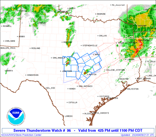
STATUS REPORT ON WW 96

THE SEVERE WEATHER THREAT CONTINUES ACROSS THE ENTIRE WATCH AREA.

..LEITMAN..04/02/25

ATTN...WFO...TSA...SGF...


STATUS REPORT FOR WT 96

SEVERE WEATHER THREAT CONTINUES FOR THE FOLLOWING AREAS

ARC007-015-033-047-087-131-143-021340-

AR
.    ARKANSAS COUNTIES INCLUDED ARE

BENTON               CARROLL             CRAWFORD
FRANKLIN             MADISON             SEBASTIAN
WASHINGTON


KSC011-021-037-021340-

KS
.    KANSAS COUNTIES INCLUDED ARE

BOURBON              CHEROKEE            CRAWFORD


MOC009-011-015-029-039-043-057-059-077-085-097-105-109-119-131-
141-145-167-185-209-213-217-225-021340-

MO
.    MISSOURI COUNTIES INCLUDED ARE

BARRY                BARTON              BENTON
CAMDEN               CEDAR               CHRISTIAN
https://www.spc.noaa.gov/products/watch/ws0096.html
date: 2025-04-02, from: NOAA tornado/severe thunderstorm watches, mesoscale discussions, convective outlooks, fire weather outlooks
URGENT - IMMEDIATE BROADCAST REQUESTED
Tornado Watch Number 96
NWS Storm Prediction Center Norman OK
520 AM CDT Wed Apr 2 2025

The NWS Storm Prediction Center has issued a

* Tornado Watch for portions of
  Northwest Arkansas
  Far Southeast Kansas
  Southwest and Central Missouri
  Eastern Oklahoma

* Effective this Wednesday morning from 520 AM until NOON CDT.

* Primary threats include...
  A few tornadoes and a couple intense tornadoes possible
  Scattered damaging winds likely with isolated significant gusts
    to 75 mph possible
  Scattered large hail and isolated very large hail events to 2
    inches in diameter possible

SUMMARY...A line of thunderstorms will continue to pose a threat of
scattered severe/damaging winds through the morning, with peak gusts
up to 65-75 mph. Embedded supercells should also have a tornado and
large hail risk, with a strong tornado possible.

The tornado watch area is approximately along and 55 statute miles
east and west of a line from 75 miles north of Springfield MO to 30
miles south southwest of Poteau OK. For a complete depiction of the
watch see the associated watch outline update (WOUS64 KWNS WOU6).

PRECAUTIONARY/PREPAREDNESS ACTIONS...

REMEMBER...A Tornado Watch means conditions are favorable for
tornadoes and severe thunderstorms in and close to the watch
area. Persons in these areas should be on the lookout for
threatening weather conditions and listen for later statements
and possible warnings.

&&

OTHER WATCH INFORMATION...CONTINUE...WW 93...WW 94...WW 95...

AVIATION...Tornadoes and a few severe thunderstorms with hail
surface and aloft to 2 inches. Extreme turbulence and surface wind
gusts to 65 knots. A few cumulonimbi with maximum tops to 500. Mean
storm motion vector 25045.

...Gleason
https://www.spc.noaa.gov/products/watch/ww0096.html
date: 2025-04-02, from: NOAA tornado/severe thunderstorm watches, mesoscale discussions, convective outlooks, fire weather outlooks
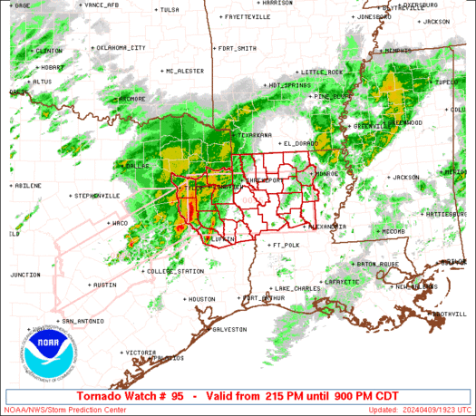
URGENT - IMMEDIATE BROADCAST REQUESTED
Tornado Watch Number 95
NWS Storm Prediction Center Norman OK
245 AM CDT Wed Apr 2 2025

The NWS Storm Prediction Center has issued a

* Tornado Watch for portions of
  Oklahoma

* Effective this Wednesday morning from 245 AM until 1000 AM CDT.

* Primary threats include...
  A few tornadoes and a couple intense tornadoes possible
  Scattered damaging winds likely with isolated significant gusts
    to 75 mph possible
  Scattered large hail and isolated very large hail events to 2.5
    inches in diameter possible

SUMMARY...Thunderstorms are expected to continue developing along a
cold front this morning. This convection should pose a threat for a
few tornadoes, scattered severe/damaging winds, and perhaps large
hail with any embedded supercells. A strong tornado appears
possible.

The tornado watch area is approximately along and 95 statute miles
east and west of a line from 30 miles west northwest of Bartlesville
OK to 50 miles southeast of Chickasha OK. For a complete depiction
of the watch see the associated watch outline update (WOUS64 KWNS
WOU5).

PRECAUTIONARY/PREPAREDNESS ACTIONS...

REMEMBER...A Tornado Watch means conditions are favorable for
tornadoes and severe thunderstorms in and close to the watch
area. Persons in these areas should be on the lookout for
threatening weather conditions and listen for later statements
and possible warnings.

&&

OTHER WATCH INFORMATION...CONTINUE...WW 92...WW 93...WW 94...

AVIATION...Tornadoes and a few severe thunderstorms with hail
surface and aloft to 2.5 inches. Extreme turbulence and surface wind
gusts to 65 knots. A few cumulonimbi with maximum tops to 500. Mean
storm motion vector 24045.

...Gleason
https://www.spc.noaa.gov/products/watch/ww0095.html
date: 2025-04-02, from: NOAA tornado/severe thunderstorm watches, mesoscale discussions, convective outlooks, fire weather outlooks
STATUS REPORT ON WW 95

SEVERE WEATHER THREAT CONTINUES RIGHT OF A LINE FROM 20 W ADM TO
45 WNW MLC TO 20 S TUL TO 40 SSE CNU.

..LEITMAN..04/02/25

ATTN...WFO...OUN...TSA...


STATUS REPORT FOR WT 95

SEVERE WEATHER THREAT CONTINUES FOR THE FOLLOWING AREAS

OKC029-063-099-111-123-131-021340-

OK
.    OKLAHOMA COUNTIES INCLUDED ARE

COAL                 HUGHES              MURRAY
OKMULGEE             PONTOTOC            ROGERS


THE WATCH STATUS MESSAGE IS FOR GUIDANCE PURPOSES ONLY.  PLEASE
REFER TO WATCH COUNTY NOTIFICATION STATEMENTS FOR OFFICIAL
INFORMATION ON COUNTIES...INDEPENDENT CITIES AND MARINE ZONES
CLEARED FROM SEVERE THUNDERSTORM AND TORNADO WATCHES.
https://www.spc.noaa.gov/products/watch/ws0095.html
date: 2025-04-02, from: NOAA tornado/severe thunderstorm watches, mesoscale discussions, convective outlooks, fire weather outlooks
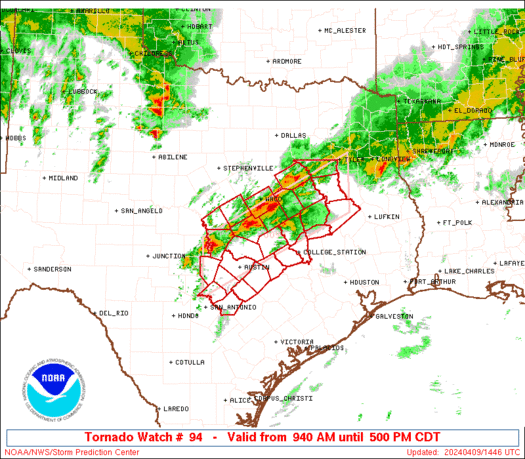
URGENT - IMMEDIATE BROADCAST REQUESTED
Tornado Watch Number 94
NWS Storm Prediction Center Norman OK
230 AM CDT Wed Apr 2 2025

The NWS Storm Prediction Center has issued a

* Tornado Watch for portions of
  Far Eastern Kansas
  Western and Northern Missouri

* Effective this Wednesday morning from 230 AM until 1000 AM CDT.

* Primary threats include...
  A couple tornadoes possible
  Scattered damaging winds likely with isolated significant gusts
    to 75 mph possible
  Isolated very large hail events to 2 inches in diameter possible

SUMMARY...A line of thunderstorms is expected to move quickly east-
northeastward this morning while posing a threat for scattered
severe/damaging winds. Isolated large hail and a couple of tornadoes
may also occur.

The tornado watch area is approximately along and 70 statute miles
east and west of a line from 45 miles south of Olathe KS to 35 miles
north of Chillicothe MO. For a complete depiction of the watch see
the associated watch outline update (WOUS64 KWNS WOU4).

PRECAUTIONARY/PREPAREDNESS ACTIONS...

REMEMBER...A Tornado Watch means conditions are favorable for
tornadoes and severe thunderstorms in and close to the watch
area. Persons in these areas should be on the lookout for
threatening weather conditions and listen for later statements
and possible warnings.

&&

OTHER WATCH INFORMATION...CONTINUE...WW 92...WW 93...

AVIATION...Tornadoes and a few severe thunderstorms with hail
surface and aloft to 2 inches. Extreme turbulence and surface wind
gusts to 65 knots. A few cumulonimbi with maximum tops to 500. Mean
storm motion vector 25045.

...Gleason
https://www.spc.noaa.gov/products/watch/ww0094.html
date: 2025-04-02, from: NOAA tornado/severe thunderstorm watches, mesoscale discussions, convective outlooks, fire weather outlooks
STATUS REPORT ON WW 94

SEVERE WEATHER THREAT CONTINUES RIGHT OF A LINE FROM 50 SSE OJC
TO 20 W SZL TO 30 NE SZL TO 30 N COU.

..LEITMAN..04/02/25

ATTN...WFO...EAX...


STATUS REPORT FOR WT 94

SEVERE WEATHER THREAT CONTINUES FOR THE FOLLOWING AREAS

MOC013-053-083-089-101-159-195-021340-

MO
.    MISSOURI COUNTIES INCLUDED ARE

BATES                COOPER              HENRY
HOWARD               JOHNSON             PETTIS
SALINE


THE WATCH STATUS MESSAGE IS FOR GUIDANCE PURPOSES ONLY.  PLEASE
REFER TO WATCH COUNTY NOTIFICATION STATEMENTS FOR OFFICIAL
INFORMATION ON COUNTIES...INDEPENDENT CITIES AND MARINE ZONES
CLEARED FROM SEVERE THUNDERSTORM AND TORNADO WATCHES.
https://www.spc.noaa.gov/products/watch/ws0094.html
date: 2025-04-02, from: NOAA tornado/severe thunderstorm watches, mesoscale discussions, convective outlooks, fire weather outlooks
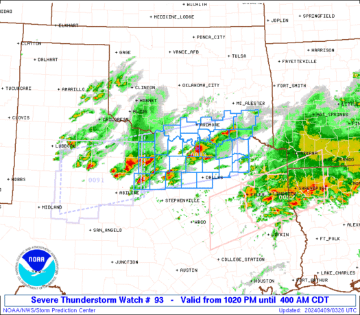
STATUS REPORT ON WW 93

SEVERE WEATHER THREAT CONTINUES RIGHT OF A LINE FROM 30 NE PNC TO
40 W CNU TO 20 E EMP TO 20 WNW OJC.

..LEITMAN..04/02/25

ATTN...WFO...ICT...TOP...


STATUS REPORT FOR WT 93

SEVERE WEATHER THREAT CONTINUES FOR THE FOLLOWING AREAS

KSC001-003-019-031-049-059-099-125-133-205-207-021040-

KS
.    KANSAS COUNTIES INCLUDED ARE

ALLEN                ANDERSON            CHAUTAUQUA
COFFEY               ELK                 FRANKLIN
LABETTE              MONTGOMERY          NEOSHO
WILSON               WOODSON


THE WATCH STATUS MESSAGE IS FOR GUIDANCE PURPOSES ONLY.  PLEASE
REFER TO WATCH COUNTY NOTIFICATION STATEMENTS FOR OFFICIAL
INFORMATION ON COUNTIES...INDEPENDENT CITIES AND MARINE ZONES
CLEARED FROM SEVERE THUNDERSTORM AND TORNADO WATCHES.
https://www.spc.noaa.gov/products/watch/ws0093.html
date: 2025-03-31, from: NOAA tornado/severe thunderstorm watches, mesoscale discussions, convective outlooks, fire weather outlooks
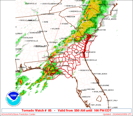
STATUS REPORT ON WW 85

SEVERE WEATHER THREAT CONTINUES RIGHT OF A LINE FROM 25 SSE CBM
TO 40 WNW BHM TO 5 WSW HSV TO 50 W CHA.

..LEITMAN..03/31/25

ATTN...WFO...BMX...HUN...FFC...MEG...


STATUS REPORT FOR WS 85

SEVERE WEATHER THREAT CONTINUES FOR THE FOLLOWING AREAS

ALC001-007-009-011-015-017-019-021-027-029-037-043-047-049-051-
055-063-065-071-073-081-085-087-089-091-095-101-103-105-107-111-
113-115-117-119-121-123-125-127-311340-

AL
.    ALABAMA COUNTIES INCLUDED ARE

AUTAUGA              BIBB                BLOUNT
BULLOCK              CALHOUN             CHAMBERS
CHEROKEE             CHILTON             CLAY
CLEBURNE             COOSA               CULLMAN
DALLAS               DEKALB              ELMORE
ETOWAH               GREENE              HALE
JACKSON              JEFFERSON           LEE
LOWNDES              MACON               MADISON
MARENGO              MARSHALL            MONTGOMERY
MORGAN               PERRY               PICKENS
RANDOLPH             RUSSELL             ST. CLAIR
SHELBY               SUMTER              TALLADEGA
TALLAPOOSA           TUSCALOOSA          WALKER


GAC047-055-083-295-311340-

GA
https://www.spc.noaa.gov/products/watch/ws0085.html
date: 2025-03-31, from: NOAA tornado/severe thunderstorm watches, mesoscale discussions, convective outlooks, fire weather outlooks
URGENT - IMMEDIATE BROADCAST REQUESTED
Severe Thunderstorm Watch Number 85
NWS Storm Prediction Center Norman OK
445 AM CDT Mon Mar 31 2025

The NWS Storm Prediction Center has issued a

* Severe Thunderstorm Watch for portions of
  Northern and Central Alabama
  Far Northwest Georgia
  Northeast Mississippi

* Effective this Monday morning from 445 AM until NOON CDT.

* Primary threats include...
  Scattered damaging wind gusts to 70 mph likely
  Isolated large hail events to 1.5 inches in diameter possible
  A tornado or two possible

SUMMARY...Multiple lines and clusters of thunderstorms are expected
to spread eastward this morning across much of northern/central
Alabama and into far northwest Georgia. Scattered severe/damaging
winds should be the main threat with this activity, although
isolated hail and perhaps a tornado or two may also occur.

The severe thunderstorm watch area is approximately along and 75
statute miles east and west of a line from 25 miles northeast of
Huntsville AL to 20 miles south southwest of Selma AL. For a
complete depiction of the watch see the associated watch outline
update (WOUS64 KWNS WOU5).

PRECAUTIONARY/PREPAREDNESS ACTIONS...

REMEMBER...A Severe Thunderstorm Watch means conditions are
favorable for severe thunderstorms in and close to the watch area.
Persons in these areas should be on the lookout for threatening
weather conditions and listen for later statements and possible
warnings. Severe thunderstorms can and occasionally do produce
tornadoes.

&&

OTHER WATCH INFORMATION...CONTINUE...WW 81...WW 82...WW 83...WW
84...

AVIATION...A few severe thunderstorms with hail surface and aloft to
1.5 inches. Extreme turbulence and surface wind gusts to 60 knots. A
few cumulonimbi with maximum tops to 500. Mean storm motion vector
27035.

...Gleason
https://www.spc.noaa.gov/products/watch/ww0085.html
date: 2025-03-31, from: NOAA tornado/severe thunderstorm watches, mesoscale discussions, convective outlooks, fire weather outlooks
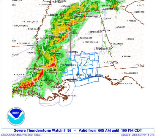
STATUS REPORT ON WW 86

THE SEVERE WEATHER THREAT CONTINUES ACROSS THE ENTIRE WATCH AREA.

..LEITMAN..03/31/25

ATTN...WFO...MOB...


STATUS REPORT FOR WS 86

SEVERE WEATHER THREAT CONTINUES FOR THE FOLLOWING AREAS

ALC003-013-023-025-035-039-041-053-097-099-129-131-311340-

AL
.    ALABAMA COUNTIES INCLUDED ARE

BALDWIN              BUTLER              CHOCTAW
CLARKE               CONECUH             COVINGTON
CRENSHAW             ESCAMBIA            MOBILE
MONROE               WASHINGTON          WILCOX


FLC033-091-113-311340-

FL
.    FLORIDA COUNTIES INCLUDED ARE

ESCAMBIA             OKALOOSA            SANTA ROSA


MSC039-041-111-131-153-311340-

MS
.    MISSISSIPPI COUNTIES INCLUDED ARE

GEORGE               GREENE              PERRY
STONE                WAYNE
https://www.spc.noaa.gov/products/watch/ws0086.html
date: 2025-03-31, from: NOAA tornado/severe thunderstorm watches, mesoscale discussions, convective outlooks, fire weather outlooks
URGENT - IMMEDIATE BROADCAST REQUESTED
Severe Thunderstorm Watch Number 86
NWS Storm Prediction Center Norman OK
605 AM CDT Mon Mar 31 2025

The NWS Storm Prediction Center has issued a

* Severe Thunderstorm Watch for portions of
  Southern Alabama
  The Western Florida Panhandle
  Southeast Mississippi
  Coastal Waters

* Effective this Monday morning and afternoon from 605 AM until
  100 PM CDT.

* Primary threats include...
  Scattered damaging wind gusts to 70 mph likely
  Isolated large hail events to 1.5 inches in diameter possible
  A tornado or two possible

SUMMARY...A line of thunderstorms will move eastward over the next
several hours. Scattered severe/damaging winds with peak gusts up to
60-70 mph should be the main threat, although a tornado or two may
also occur.

The severe thunderstorm watch area is approximately along and 75
statute miles east and west of a line from 45 miles north northwest
of Evergreen AL to 30 miles southeast of Mobile AL. For a complete
depiction of the watch see the associated watch outline update
(WOUS64 KWNS WOU6).

PRECAUTIONARY/PREPAREDNESS ACTIONS...

REMEMBER...A Severe Thunderstorm Watch means conditions are
favorable for severe thunderstorms in and close to the watch area.
Persons in these areas should be on the lookout for threatening
weather conditions and listen for later statements and possible
warnings. Severe thunderstorms can and occasionally do produce
tornadoes.

&&

OTHER WATCH INFORMATION...CONTINUE...WW 83...WW 84...WW 85...

AVIATION...A few severe thunderstorms with hail surface and aloft to
1.5 inches. Extreme turbulence and surface wind gusts to 60 knots. A
few cumulonimbi with maximum tops to 500. Mean storm motion vector
27035.

...Gleason
https://www.spc.noaa.gov/products/watch/ww0086.html
date: 2025-03-31, from: NOAA tornado/severe thunderstorm watches, mesoscale discussions, convective outlooks, fire weather outlooks
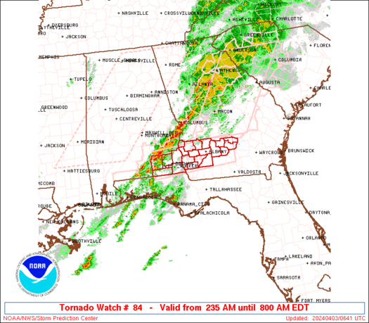
STATUS REPORT ON WW 84

SEVERE WEATHER THREAT CONTINUES RIGHT OF A LINE FROM 35 ESE LFT
TO 35 NW MSY TO 35 NNW ASD TO 15 WSW PIB.

..LEITMAN..03/31/25

ATTN...WFO...LIX...


STATUS REPORT FOR WS 84

SEVERE WEATHER THREAT CONTINUES FOR THE FOLLOWING AREAS

LAC005-007-033-051-057-071-075-087-089-093-095-103-105-109-117-
311340-

LA
.    LOUISIANA PARISHES INCLUDED ARE

ASCENSION            ASSUMPTION          EAST BATON ROUGE
JEFFERSON            LAFOURCHE           ORLEANS
PLAQUEMINES          ST. BERNARD         ST. CHARLES
ST. JAMES            ST. JOHN THE BAPTISTST. TAMMANY
TANGIPAHOA           TERREBONNE          WASHINGTON


MSC045-047-059-109-311340-

MS
.    MISSISSIPPI COUNTIES INCLUDED ARE

HANCOCK              HARRISON            JACKSON
PEARL RIVER


GMZ530-532-534-536-538-550-552-555-557-311340-

CW
https://www.spc.noaa.gov/products/watch/ws0084.html
date: 2025-03-31, from: NOAA tornado/severe thunderstorm watches, mesoscale discussions, convective outlooks, fire weather outlooks
URGENT - IMMEDIATE BROADCAST REQUESTED
Severe Thunderstorm Watch Number 84
NWS Storm Prediction Center Norman OK
345 AM CDT Mon Mar 31 2025

The NWS Storm Prediction Center has issued a

* Severe Thunderstorm Watch for portions of
  Southeast Louisiana
  Southern Mississippi
  Coastal Waters

* Effective this Monday morning from 345 AM until 1100 AM CDT.

* Primary threats include...
  Scattered damaging wind gusts to 70 mph likely
  Isolated very large hail events to 2 inches in diameter possible
  A tornado or two possible

SUMMARY...Thunderstorms are expected to consolidate into a line as
they move east-southeastward this morning. Scattered damaging winds
should be the main threat, with peak gusts potentially up to 60-70
mph. Isolated large hail around 1-2 inches in diameter and a tornado
or two may also occur.

The severe thunderstorm watch area is approximately along and 85
statute miles north and south of a line from 55 miles northwest of
Houma LA to 20 miles south southeast of Slidell LA. For a complete
depiction of the watch see the associated watch outline update
(WOUS64 KWNS WOU4).

PRECAUTIONARY/PREPAREDNESS ACTIONS...

REMEMBER...A Severe Thunderstorm Watch means conditions are
favorable for severe thunderstorms in and close to the watch area.
Persons in these areas should be on the lookout for threatening
weather conditions and listen for later statements and possible
warnings. Severe thunderstorms can and occasionally do produce
tornadoes.

&&

OTHER WATCH INFORMATION...CONTINUE...WW 80...WW 81...WW 82...WW
83...

AVIATION...A few severe thunderstorms with hail surface and aloft to
2 inches. Extreme turbulence and surface wind gusts to 60 knots. A
few cumulonimbi with maximum tops to 500. Mean storm motion vector
28035.

...Gleason
https://www.spc.noaa.gov/products/watch/ww0084.html
date: 2025-03-31, from: NOAA tornado/severe thunderstorm watches, mesoscale discussions, convective outlooks, fire weather outlooks
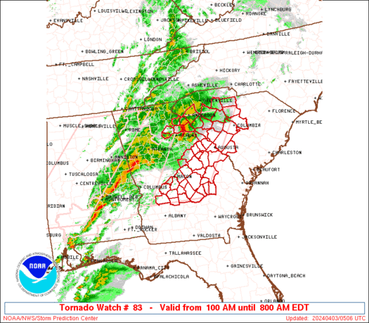
STATUS REPORT ON WW 83

SEVERE WEATHER THREAT CONTINUES RIGHT OF A LINE FROM 5 NNW LCH TO
30 NNE LFT TO 35 NW PIB TO 60 SSE GWO TO 20 SE GWO TO 20 W CBM TO
20 N CBM.

..LEITMAN..03/31/25

ATTN...WFO...JAN...SHV...LCH...


STATUS REPORT FOR WS 83

SEVERE WEATHER THREAT CONTINUES FOR THE FOLLOWING AREAS

LAC001-045-053-055-099-101-113-311240-

LA
.    LOUISIANA PARISHES INCLUDED ARE

ACADIA               IBERIA              JEFFERSON DAVIS
LAFAYETTE            ST. MARTIN          ST. MARY
VERMILION


MSC007-019-023-025-031-035-061-065-067-069-073-075-077-079-085-
087-091-099-101-103-105-123-129-159-311240-

MS
.    MISSISSIPPI COUNTIES INCLUDED ARE

ATTALA               CHOCTAW             CLARKE
CLAY                 COVINGTON           FORREST
JASPER               JEFFERSON DAVIS     JONES
KEMPER               LAMAR               LAUDERDALE
LAWRENCE             LEAKE               LINCOLN
LOWNDES              MARION              NESHOBA
NEWTON               NOXUBEE             OKTIBBEHA
SCOTT                SMITH               WINSTON
https://www.spc.noaa.gov/products/watch/ws0083.html
date: 2025-03-31, from: NOAA tornado/severe thunderstorm watches, mesoscale discussions, convective outlooks, fire weather outlooks
URGENT - IMMEDIATE BROADCAST REQUESTED
Severe Thunderstorm Watch Number 83
NWS Storm Prediction Center Norman OK
135 AM CDT Mon Mar 31 2025

The NWS Storm Prediction Center has issued a

* Severe Thunderstorm Watch for portions of
  Far Southern Arkansas
  Louisiana
  Central Mississippi
  Far East Texas

* Effective this Monday morning from 135 AM until 800 AM CDT.

* Primary threats include...
  Scattered damaging wind gusts to 70 mph likely
  Scattered large hail and isolated very large hail events to 2
    inches in diameter possible
  A tornado or two possible

SUMMARY...Thunderstorms will continue to move east-northeastward
over the next several hours early this morning, while posing a
threat for scattered damaging winds up to 60-70 mph and large hail
around 1-2 inches in diameter. A tornado or two may also occur.

The severe thunderstorm watch area is approximately along and 60
statute miles north and south of a line from 45 miles south of
Columbus MS to 75 miles west of Fort Polk LA. For a complete
depiction of the watch see the associated watch outline update
(WOUS64 KWNS WOU3).

PRECAUTIONARY/PREPAREDNESS ACTIONS...

REMEMBER...A Severe Thunderstorm Watch means conditions are
favorable for severe thunderstorms in and close to the watch area.
Persons in these areas should be on the lookout for threatening
weather conditions and listen for later statements and possible
warnings. Severe thunderstorms can and occasionally do produce
tornadoes.

&&

OTHER WATCH INFORMATION...CONTINUE...WW 77...WW 78...WW 79...WW
80...WW 81...WW 82...

AVIATION...A few severe thunderstorms with hail surface and aloft to
2 inches. Extreme turbulence and surface wind gusts to 60 knots. A
few cumulonimbi with maximum tops to 500. Mean storm motion vector
26035.

...Gleason
https://www.spc.noaa.gov/products/watch/ww0083.html
date: 2025-03-31, from: NOAA tornado/severe thunderstorm watches, mesoscale discussions, convective outlooks, fire weather outlooks
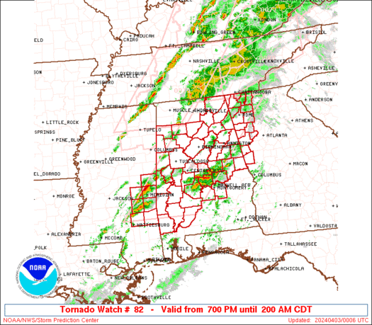
STATUS REPORT ON WW 82

SEVERE WEATHER THREAT CONTINUES RIGHT OF A LINE FROM 35 NW CHA TO
35 WSW TYS TO 5 WNW TYS TO 30 E TYS.

..LEITMAN..03/31/25

ATTN...WFO...MRX...


STATUS REPORT FOR WT 82

SEVERE WEATHER THREAT CONTINUES FOR THE FOLLOWING AREAS

TNC009-011-065-105-107-115-121-123-139-153-311040-

TN
.    TENNESSEE COUNTIES INCLUDED ARE

BLOUNT               BRADLEY             HAMILTON
LOUDON               MCMINN              MARION
MEIGS                MONROE              POLK
SEQUATCHIE


THE WATCH STATUS MESSAGE IS FOR GUIDANCE PURPOSES ONLY.  PLEASE
REFER TO WATCH COUNTY NOTIFICATION STATEMENTS FOR OFFICIAL
INFORMATION ON COUNTIES...INDEPENDENT CITIES AND MARINE ZONES
CLEARED FROM SEVERE THUNDERSTORM AND TORNADO WATCHES.
https://www.spc.noaa.gov/products/watch/ws0082.html
date: 2025-03-31, from: NOAA tornado/severe thunderstorm watches, mesoscale discussions, convective outlooks, fire weather outlooks

STATUS REPORT ON WW 81

SEVERE WEATHER THREAT CONTINUES RIGHT OF A LINE FROM 40 E PBF TO
15 E UOX TO 45 SSE MKL.

..LEITMAN..03/31/25

ATTN...WFO...HUN...BMX...MEG...JAN...


STATUS REPORT FOR WT 81

SEVERE WEATHER THREAT CONTINUES FOR THE FOLLOWING AREAS

ALC033-043-057-059-075-077-079-083-089-093-103-127-133-310940-

AL
.    ALABAMA COUNTIES INCLUDED ARE

COLBERT              CULLMAN             FAYETTE
FRANKLIN             LAMAR               LAUDERDALE
LAWRENCE             LIMESTONE           MADISON
MARION               MORGAN              WALKER
WINSTON


MSC003-013-017-057-071-081-095-115-117-135-139-141-145-161-
310940-

MS
.    MISSISSIPPI COUNTIES INCLUDED ARE

ALCORN               CALHOUN             CHICKASAW
ITAWAMBA             LAFAYETTE           LEE
MONROE               PONTOTOC            PRENTISS
TALLAHATCHIE         TIPPAH              TISHOMINGO
UNION                YALOBUSHA