(date: 2023-11-22 08:43:10)
date: 2023-11-22, from: NOAA Weather Forecasts

Day 1 Fire Weather Outlook
NWS Storm Prediction Center Norman OK
1037 AM CST Wed Nov 22 2023

Valid 221700Z - 231200Z

...NO CRITICAL AREAS...

The current D1 Fire Weather Outlook remains on track with no updates
needed. See previous discussion below.

..Thornton.. 11/22/2023

.PREV DISCUSSION... /ISSUED 0159 AM CST Wed Nov 22 2023/

...Synopsis...
Across the US, fire-weather concerns are low in the wake of broad
precipitation from the departing eastern US trough. Shortwave
ridging over the West Coast will slowly weaken as an upper low moves
south across the Pacific Northwest into the Great Basin. Weak high
pressure will persist over the central US, keeping winds light, with
the exception of some stronger offshore gusts over southern CA early
in the day. At the same time, a cold front and an accompanying
Arctic air mass will being moving south across the northern Rockies
and Plains. Much colder temperatures and snow are forecast to
develop there late into D2/Thursday. The cooler temperatures, weak
winds, moderate RH should keep fire-weather concerns limited across
the CONUS.

...Please see www.spc.noaa.gov/fire for graphic product...
https://www.spc.noaa.gov/products/fire_wx/fwdy1.html
date: 2023-11-22, from: NOAA tornado/severe thunderstorm watches, mesoscale discussions, convective outlooks, fire weather outlooks
No watches are valid as of Wed Nov 22 16:39:01 UTC 2023.
https://www.spc.noaa.gov/products/watch/
date: 2023-11-22, from: NOAA tornado/severe thunderstorm watches, mesoscale discussions, convective outlooks, fire weather outlooks

Day 1 Convective Outlook
NWS Storm Prediction Center Norman OK
1026 AM CST Wed Nov 22 2023

Valid 221630Z - 231200Z

...NO SEVERE THUNDERSTORM AREAS FORECAST...

...SUMMARY...
Organized severe thunderstorms are not expected through tonight.

...Coastal North and South Carolina...
Extensive precipitation continues in the vicinity of a cold front
currently approaching the NC coast as of 16z. Transient areas of
higher reflectivity denoting somewhat stronger updrafts have been
observed earlier this morning in the vicinity of New Bern,
Jacksonville and Morehead City, however overall storm structures
remain disorganized. Large scale ascent will increase in the
vicinity of the cold front and a pre-frontal confluence zone as an
upper-level trough moves steadily towards the mid-Atlantic coast
this afternoon. Weak inland buoyancy (MLCAPE locally 750 J/kg) and
40 kts of westerly shear may prove sufficient for a couple of
stronger storms through early afternoon, especially in the immediate
coastal waters, however the overall severe threat over land appears
to have diminished. As a result, the Marginal Risk has been removed
with this outlook.

Elsewhere, the potential for scattered thunderstorms will exist in
advance of the front over the FL Peninsula, otherwise generally
stable conditions should preclude thunderstorms over most of the
CONUS.

..Bunting/Flournoy.. 11/22/2023
https://www.spc.noaa.gov/products/outlook/day1otlk_1630.html
date: 2023-11-22, from: Eastern Pacific Basin GIS Data
No tropical cyclones as of Wed, 22 Nov 2023 15:37:41 GMT
date: 2023-11-22, from: NOAA tornado/severe thunderstorm watches, mesoscale discussions, convective outlooks, fire weather outlooks
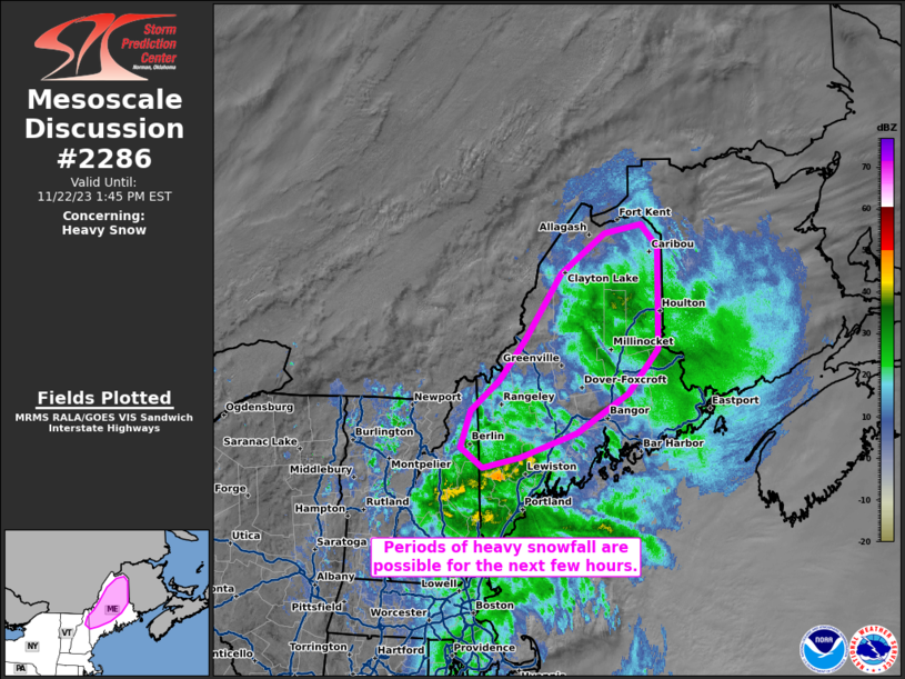
Mesoscale Discussion 2286
NWS Storm Prediction Center Norman OK
0850 AM CST Wed Nov 22 2023

Areas affected...northern Maine and northeastern New Hampshire

Concerning...Heavy snow

Valid 221450Z - 221845Z

SUMMARY...Periods of heavy snowfall, with rates up to 1-1.5 inches
per hour, are possible for the next few hours across northern Maine
and northeastern New Hampshire.

DISCUSSION...Heavy snowfall rates have been observed this morning
across portions of northern Maine. This activity is associated with
a surface cyclone currently analyzed along the southern New England
coast. The cyclone should continue to gradually deepen throughout
the morning due to differential cyclonic vorticity advection (ahead
of a mid-level shortwave trough) and low-level coastal baroclinity
as it moves east-northeastward. 12z GYX/CAR soundings exhibited
strong veering in the lowest ~3 km AGL, indicative of widespread
low-level warm-air advection. Temperatures aloft in the lowest 3 km
AGL are nearly isothermal and below freezing, except nearer to the
coast where surface temperatures rising into the 40s F are observed.
Farther inland, the continued northward moisture flux atop colder
surface conditions could contribute to periods of heavy snowfall
(1-1.5 inches per hour) for the next few hours.

..Flournoy.. 11/22/2023

...Please see www.spc.noaa.gov for graphic product...

ATTN...WFO...CAR...GYX...

LAT...LON   44307029 44606929 45106840 45656787 46916786 47196816
            47096881 46596959 45767021 45257067 44887117 44427133
            44177094 44307029
https://www.spc.noaa.gov/products/md/md2286.html
date: 2023-11-22, from: NOAA tornado/severe thunderstorm watches, mesoscale discussions, convective outlooks, fire weather outlooks

Day 1 Convective Outlook
NWS Storm Prediction Center Norman OK
0647 AM CST Wed Nov 22 2023

Valid 221300Z - 231200Z

...THERE IS A MARGINAL RISK OF SEVERE THUNDERSTORMS PORTIONS OF
EASTERN NORTH CAROLINA AND THE OUTER BANKS...

...SUMMARY...
A brief tornado and localized damaging-gust threat are possible this
morning across portions of eastern North Carolina and the Outer
Banks.

...Synopsis...
A progressive mid/upper-level pattern will remain in place through
the period, except for a split-flow regime around a cut-off low over
northwestern MX.  Farther northeast, a nearly closed 500-mb low was
apparent in moisture-channel imagery over the Mid-South, anchoring
an intense shortwave trough that extended south-southwestward over
parts of LA.  The low and trough are pivoting eastward and should
cross the Tennessee Valley and southern Appalachians today, reaching
the NC/SC Piedmont by 00Z.  The perturbation then should race
offshore.

At the surface, a cold front was analyzed at 11Z from NJ to a
frontal wave over north-central NC, then across central SC, eastern
GA, the FL coastal-bend area, and northeastern Gulf.  The front is
expected to move offshore from NC around 17-18Z, while crossing
parts of north FL.  The front should reach central/southwestern FL
around 00Z, and move off south FL and the Keys by 12Z.

...Eastern NC...
A marginal tornado and severe-wind threat remains over this area for
a few more hours, especially ahead of the front, and perhaps until
convection along the front passes.  See SPC mesoscale discussion
2285 for near-term details.

The approaching shortwave trough and related mass response may
increase both low-level lift and large-scale ascent over the area
through midday, while maintaining somewhat veered but enlarged
low-level hodographs (as seen in the 12Z MHX RAOB), along with
moisture transport/theta-e advection near the coast.  Meanwhile,
strengthening mid/upper winds will help to offset some veering of
surface flow in maintaining favorable deep shear for supercells,
and/or organized line(s) of convection with embedded areas of at
least transient rotation.  Messy convective mode and lack of greater
buoyancy (due to weak deep-layer lapse rates) over land will be
limiting factors for severe potential.

..Edwards/Broyles.. 11/22/2023
https://www.spc.noaa.gov/products/outlook/day1otlk_1300.html
date: 2023-11-22, from: Eastern Pacific Tropical Weather Outlook
000
ABPZ20 KNHC 221150
TWOEP
Tropical Weather Outlook
NWS National Hurricane Center Miami
FL
400 AM PST Wed Nov 22 2023
For the eastern North
Pacific…east of 140 degrees west longitude:
Central East
Pacific (EP94):
Shower and thunderstorm activity associated with
an area of low
pressure located well south-southwest of the
southern tip of the
Baja California peninsula has not become
better organized since
yesterday. Environmental conditions appear
marginally conducive for
some gradual development of this system
during the next few days
while it drifts generally northward.
Environmental conditions are
forecast to become less conducive
for development by this weekend or
early next week.
*
Formation chance through 48 hours…low…30 percent.
* Formation
chance through 7 days…low…30 percent.
$$
Forecaster
Reinhart
https://www.nhc.noaa.gov/gtwo.php?basin=epac
date: 2023-11-22, from: Graphical Tropical Weather Outlooks
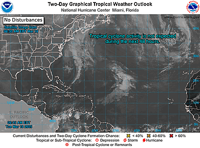
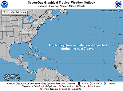
ZCZC MIATWOAT ALL
TTAA00 KNHC DDHHMM
Tropical Weather Outlook
NWS National Hurricane Center Miami
FL
700 AM EST Wed Nov 22 2023
For the North
Atlantic…Caribbean Sea and the Gulf of Mexico:
1. Central
Subtropical Atlantic:
An area of low pressure is expected to
develop along a frontal
boundary over the central subtropical
Atlantic in a day or so. This
non-tropical low is forecast to
move southeastward across the
central subtropical Atlantic over
warmer sea surface temperatures
during the next few days, and
environmental conditions could allow
for this system to gradually
acquire tropical or subtropical
characteristics. A subtropical or
tropical storm could form by the
latter part of this week or this
weekend, as the system turns
northeastward by the weekend.
* Formation chance through 48 hours…low…20 percent.
* Formation
chance through 7 days…medium…50 percent.
Forecaster
Kelly
https://www.nhc.noaa.gov/gtwo.php?basin=atlc
date: 2023-11-22, from: Central Pacific Basin Tropical Cyclones
000
ACPN50 PHFO 221147
TWOCP
Tropical
Weather Outlook
NWS Central Pacific Hurricane Center Honolulu
HI
200 AM HST Wed Nov 22 2023
For the central North
Pacific…between 140W and 180W:
No tropical cyclones are
expected during the next 7 days.
$$
Forecaster
Almanza
https://www.nhc.noaa.gov/gtwo.php?basin=cpac
date: 2023-11-22, from: Central Pacific Basin Tropical Cyclones
No tropical cyclones as of Wed, 22 Nov 2023 15:37:41 GMT
date: 2023-11-21, from: NOAA tornado/severe thunderstorm watches, mesoscale discussions, convective outlooks, fire weather outlooks
No Mesoscale Discussions are in effect as of Tue Nov 21 05:00:25 UTC 2023.
https://www.spc.noaa.gov/products/md/
date: 2023-11-21, from: NOAA tornado/severe thunderstorm watches, mesoscale discussions, convective outlooks, fire weather outlooks

URGENT - IMMEDIATE BROADCAST REQUESTED
Tornado Watch Number 712
NWS Storm Prediction Center Norman OK
350 PM CST Mon Nov 20 2023

The NWS Storm Prediction Center has issued a

* Tornado Watch for portions of
  Southeastern Louisiana
  Southern and Central Mississippi

* Effective this Monday afternoon and evening from 350 PM until
  1100 PM CST.

* Primary threats include...
  A few tornadoes likely with a couple intense tornadoes possible
  Scattered damaging wind gusts to 70 mph likely
  Isolated large hail events to 1.5 inches in diameter possible

SUMMARY...Thunderstorms will move eastward this afternoon and
evening while posing a threat for tornadoes, damaging winds, and
isolated hail. The threat for strong tornadoes will likely persist
with any sustained supercell.

The tornado watch area is approximately along and 90 statute miles
north and south of a line from 30 miles north northwest of Natchez
MS to 45 miles north northeast of Pine Belt MS. For a complete
depiction of the watch see the associated watch outline update
(WOUS64 KWNS WOU2).

PRECAUTIONARY/PREPAREDNESS ACTIONS...

REMEMBER...A Tornado Watch means conditions are favorable for
tornadoes and severe thunderstorms in and close to the watch
area. Persons in these areas should be on the lookout for
threatening weather conditions and listen for later statements
and possible warnings.

&&

OTHER WATCH INFORMATION...CONTINUE...WW 711...

AVIATION...Tornadoes and a few severe thunderstorms with hail
surface and aloft to 1.5 inches. Extreme turbulence and surface wind
gusts to 60 knots. A few cumulonimbi with maximum tops to 450. Mean
storm motion vector 26040.

...Gleason
https://www.spc.noaa.gov/products/watch/ww0712.html
date: 2023-11-21, from: NOAA tornado/severe thunderstorm watches, mesoscale discussions, convective outlooks, fire weather outlooks

STATUS REPORT ON WW 712

SEVERE WEATHER THREAT CONTINUES RIGHT OF A LINE FROM 15 WSW HEZ
TO 55 NNE MCB TO 45 E GWO.

..LYONS..11/21/23

ATTN...WFO...LIX...JAN...


STATUS REPORT FOR WT 712

SEVERE WEATHER THREAT CONTINUES FOR THE FOLLOWING AREAS

LAC033-037-063-077-091-103-105-117-121-125-210340-

LA
.    LOUISIANA PARISHES INCLUDED ARE

EAST BATON ROUGE     EAST FELICIANA      LIVINGSTON
POINTE COUPEE        ST. HELENA          ST. TAMMANY
TANGIPAHOA           WASHINGTON          WEST BATON ROUGE
WEST FELICIANA


MSC001-005-019-023-029-031-035-037-061-065-067-069-073-075-077-
079-085-091-099-101-103-109-113-121-123-127-129-147-157-159-
210340-

MS
.    MISSISSIPPI COUNTIES INCLUDED ARE

ADAMS                AMITE               CHOCTAW
CLARKE               COPIAH              COVINGTON
FORREST              FRANKLIN            JASPER
JEFFERSON DAVIS      JONES               KEMPER
LAMAR                LAUDERDALE          LAWRENCE
LEAKE                LINCOLN             MARION
NESHOBA              NEWTON              NOXUBEE
https://www.spc.noaa.gov/products/watch/ws0712.html
date: 2023-11-21, from: NOAA tornado/severe thunderstorm watches, mesoscale discussions, convective outlooks, fire weather outlooks
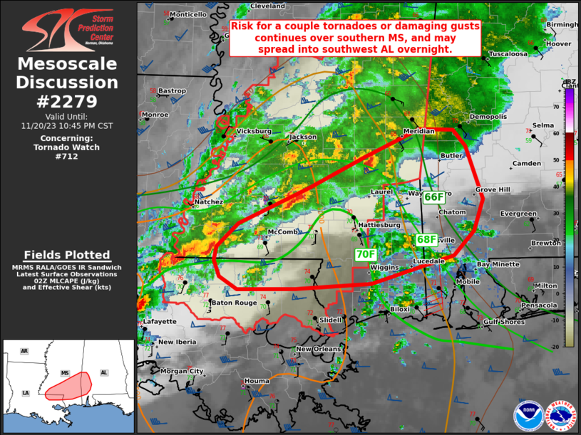
Mesoscale Discussion 2279
NWS Storm Prediction Center Norman OK
0847 PM CST Mon Nov 20 2023

Areas affected...southern Mississippi into southwest Alabama

Concerning...Tornado Watch 712...

Valid 210247Z - 210445Z

The severe weather threat for Tornado Watch 712 continues.

SUMMARY...A tornado or two remains possible this evening over
southern Mississippi, with a few damaging gusts possible as well.
The severe risk may eventually spread into parts of southwest
Alabama later tonight.

DISCUSSION...A broken line of storms including a few supercells
currently stretch east-central MS southwestward into southwest LA.
Deep-layer shear remain favorable to sustain cells this evening,
with effective SRH maximized over central MS currently.

Persistent southerly winds in the lower 2 km will continue to aid
moisture advection, with upper 60s F dewpoints spreading north
across southwest AL ahead of the ongoing MS storms. A somewhat
stable air mass exists east of a batch of warm advection showers now
forming over southwest AL, and this general zone may be as far east
as the main severe risk gets tonight.

As cells continue east across MS and approach the AL state line,
additional watches may be considered.

..Jewell.. 11/21/2023

...Please see www.spc.noaa.gov for graphic product...

ATTN...WFO...BMX...MOB...JAN...LIX...

LAT...LON   31389080 31788989 32128918 32448848 32428803 32258787
            31668765 31318778 31048803 30738909 30669006 30669082
            30809105 30979112 31139108 31389080
https://www.spc.noaa.gov/products/md/md2279.html
date: 2023-11-21, from: NOAA tornado/severe thunderstorm watches, mesoscale discussions, convective outlooks, fire weather outlooks

Day 1 Convective Outlook
NWS Storm Prediction Center Norman OK
0656 PM CST Mon Nov 20 2023

Valid 210100Z - 211200Z

...THERE IS AN ENHANCED RISK OF SEVERE THUNDERSTORMS ACROSS PORTIONS
OF THE LOWER MISSISSIPPI VALLEY...

...SUMMARY...
Tornadoes, a couple of which may be strong, scattered damaging
thunderstorm winds, and isolated large hail remain possible tonight
across portions of the lower Mississippi Valley.

...01z Update...

Primary change to 20z outlook is to lower severe probabilities along
the cool side of the progressive cold front.

Upper low centered over southeast KS continues its slow eastward
progression toward southern MO. As a result, high-level diffluent
flow has strengthened over the Gulf States. This appears partly
responsible for a corridor of severe deep convection that currently
extends from eastern LA into central MS. Within this corridor,
scattered supercells are observed, at least a few of these are
potentially tornadic. 00z sounding from JAN exhibited modest MLCAPE
(~800 J/kg) with very strong surface-6km shear (70kt), and 0-3km SRH
around 350 m2/s2. Some additional air mass recovery is expected
immediately downstream of this activity into western AL as primary
surface low lifts northeast into the OH Valley. While the primary
dynamic forcing will gradually shift north, southern portions of a
strong LLJ will shift east overnight which should allow the
aforementioned corridor of severe to advance across MS into western
AL.

..Darrow.. 11/21/2023
https://www.spc.noaa.gov/products/outlook/day1otlk_0100.html
date: 2023-11-21, from: NOAA tornado/severe thunderstorm watches, mesoscale discussions, convective outlooks, fire weather outlooks

STATUS REPORT ON WW 711

SEVERE WEATHER THREAT CONTINUES RIGHT OF A LINE FROM 25 NNE BPT
TO 15 N POE TO 25 NNW HEZ.

..SQUITIERI..11/20/23

ATTN...WFO...JAN...SHV...LCH...HGX...


STATUS REPORT FOR WT 711

SEVERE WEATHER THREAT CONTINUES FOR THE FOLLOWING AREAS

LAC001-003-009-011-019-025-029-035-039-053-059-065-079-097-107-
210040-

LA
.    LOUISIANA PARISHES INCLUDED ARE

ACADIA               ALLEN               AVOYELLES
BEAUREGARD           CALCASIEU           CATAHOULA
CONCORDIA            EAST CARROLL        EVANGELINE
JEFFERSON DAVIS      LA SALLE            MADISON
RAPIDES              ST. LANDRY          TENSAS


THE WATCH STATUS MESSAGE IS FOR GUIDANCE PURPOSES ONLY.  PLEASE
REFER TO WATCH COUNTY NOTIFICATION STATEMENTS FOR OFFICIAL
INFORMATION ON COUNTIES...INDEPENDENT CITIES AND MARINE ZONES
CLEARED FROM SEVERE THUNDERSTORM AND TORNADO WATCHES.
https://www.spc.noaa.gov/products/watch/ws0711.html
date: 2023-11-20, from: NOAA Weather Forecasts
Day 3-8 Fire Weather Outlook
NWS Storm Prediction Center Norman OK
0341 PM CST Mon Nov 20 2023

Valid 221200Z - 281200Z

Shortwave ridging across the central U.S. will give way to a trough
digging into the Southwest towards the end of this week. Thereafter,
model guidance suggests broad troughing will develop across much of
the CONUS into next weekend. Differences in the upper-level pattern
grow large beginning next week. At the surface, a cold front will
move into the northern/central Plains late this week. A secondary
push of cold air is expected to shove the front farther south by
early next week. High pressure will again become more prominent in
the West this weekend.

...Southern High Plains...
Some dry and windy conditions are possible this Thursday as a weak
surface low develops as the synoptic trough advances eastward. With
temperatures being cooler due to the earlier passage of a cold
front, RH values appear marginally low and winds may not be overly
strong. Coupled with fuels generally being unreceptive, fire weather
concerns are not likely to be more than locally elevated.

...Southern California...
Offshore flow is expected to return to the region this coming
weekend into Monday. Pressure gradient forecasts suggest potential
for near-critical meteorological conditions. Upper-level wind
support appears weak to modest. With dry conditions expected in the
interim, it is possible that some fire weather concerns could
develop. Fuel moisture trends will continue to be monitored.
Confidence in critical fire weather remains too low for highlights
this far in advance.

..Wendt.. 11/20/2023

...Please see www.spc.noaa.gov/fire for graphic product...